Southeast Arabia
Related Events
Filter results
Showing 10 events out of 76 total
Modern humans learn to modulate voice into audible oral speech in the period beginning around 70,000 BCE; this is a development apparently not accomplished by other archaic hominids and one peculiar to our species.
Some also learn at this time to count beyond “one, two, and many.”
The descendants of the immigrants to West Asia who had remained in the south (or taken the southern route) had spread generation by generation around the coast of Arabia and the Iranian plateau until they reached India.
One of the groups that had gone north (east Asians were the second group) had ventured inland and radiated to Europe, eventually displacing the Neanderthals.
They had also radiated to India from Central Asia.
The former group headed along the southeast coast of Asia, reaching Australia between fifty-five thousand and thirty thousand years ago, with most estimates placing it about forty-six thousand to forty-one thousand years ago.
Sea level is much lower during this time, and most of Maritime Southeast Asia is one land mass known as the lost continent of Sunda.
The settlers probably continued on the coastal route southeast until they reached the series of straits between Sunda and Sahul, the continental land mass that was made up of present-day Australia and New Guinea.
The widest gaps are on the Weber Line and are at least ninety kilometers wide, indicating that settlers had knowledge of seafaring skills.
Archaic humans such as Homo erectus never reached Australia.
If these dates are correct, Australia was populated up to ten thousand years before Europe.
This is possible because humans avoided the colder regions of the North favoring the warmer tropical regions to which they were adapted given their African homeland.
Another piece of evidence favoring human occupation in Australia is that about forty-six thousand years ago, all large mammals weighing more than one hundred kilograms suddenly became extinct.
The new settlers were likely to be responsible for this extinction.
Many of the animals may have been accustomed to living without predators and become docile and vulnerable to attack (as will occur later in the Americas).
The small population of moderns had spread from the Near East to South Asia by fifty thousand years ago, and on to Australia by forty thousand years ago, Homo sapiens for the first time colonizing territory never reached by Homo erectus.
It has been estimated that from a population of two thousand to five thousand individuals in Africa, only a small group, possibly as few as one hundred and fifty to one thousand people, crossed the Red Sea.
Of all the lineages present in Africa only the female descendants of one lineage, mtDNA haplogroup L3, are found outside Africa.
Had there been several migrations one would expect descendants of more than one lineage to be found outside Africa.
L3's female descendants, the M and N haplogroup lineages, are found in very low frequencies in Africa (although haplogroup M1 is very ancient and diversified in North and Northeast Africa) and appear to be recent arrivals.
A possible explanation is that these mutations occurred in East Africa shortly before the exodus and, by the founder effect, became the dominant haplogroups after the exodus from Africa.
Alternatively, the mutations may have arisen shortly after the exodus from Africa.
Some genetic evidence points to migrations out of Africa along two routes.
However, other studies suggest that only a few people left Africa in a single migration that went on to populate the rest of the world, based in the fact that only descents of L3 are found outside Africa.
From that settlement, some others point to the possibility of several waves of expansion.
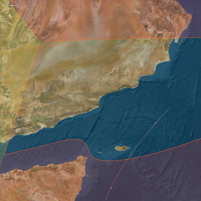
Southeast Arabia (49,293 – 28,578 BCE) Upper Pleistocene I — Monsoon Margins, Highland Refugia, and Desert Shelves
Geographic and Environmental Context
Southeast Arabia covers the southern and eastern margins of the Arabian Peninsula:-
Eastern Yemen (Hadhramaut, eastern Aden interior, al-Mahra).
-
Southern Oman (Dhofar Highlands with the khareef monsoon, al-Wusta gravel plains, Sharqiyah Desert fringes).
-
The Empty Quarter (Rubʿ al-Khālī) margins in adjoining Saudi territory.
-
The offshore island of Socotra in the Arabian Sea.
-
Anchors: Wādī Ḥaḍramawt–Shibam–Tarim, Dhofar escarpments (Ẓafār/Al-Balīd, Mirbat), al-Mahra dunes, al-Wusta plains, Sharqiyah sands, Socotra’s Hagghier Mountains and dragon’s-blood groves.
-
Coastal plains alternated with limestone scarps and gravel plains; the Dhofar escarpments trapped Indian Ocean moisture, creating fog-fed uplands.
-
Socotra lay isolated offshore, its endemic flora (dragon’s-blood trees, frankincense relatives) forming a unique biotic world, probably still uninhabited.
Climate & Environmental Shifts
-
Dansgaard–Oeschger warm interstadials: monsoon strengthened, rains reached inland wadis; ephemeral streams and pasture belts expanded.
-
Heinrich dry stadials: aridity dominated; dunes advanced; only perennial springs in highlands persisted; coastal productivity declined as upwelling weakened.
Subsistence & Settlement
-
Highlands & wadis: Foragers hunted gazelle, ibex, and small game; gathered roots, fruits, and nuts in seasonal flushes.
-
Coastal zones: Shellfish, turtle eggs, mullet, and crabs provided fallback protein in dry seasons.
-
Dry-phase strategy: Mobility focused on spring-fed uplands and the richest coastal embayments.
-
Socotra: no firm evidence for human presence, though transient visits in wet pulses cannot be excluded.
Technology & Material Culture
-
Late Middle Paleolithic flake industries dominated, with emerging microlithic elements in wetter episodes.
-
Chert/quartzite used for points and scrapers; expedient coral limestone tools along the coast.
-
Organic tools (digging sticks, nets, fish traps) likely, but preservation poor.
-
Use of ochre and shell beads attested regionally (Levant, Red Sea), suggesting shared symbolism.
Movement & Interaction Corridors
-
Coastal corridor tied southeastern Arabia to central/eastern Arabia, passable in wetter pulses.
-
Wadis linked coasts to uplands; critical routes to highland pastures.
-
Maritime: Dhofar–Mahra strip may have linked by canoe to the southern Red Sea in interstadials.
Cultural & Symbolic Expressions
-
Symbolism inferred from ochre and ornaments in adjacent regions.
-
Seasonal aggregation likely at highland springs and productive coves.
Environmental Adaptation & Resilience
-
Dual mobility (upland springs + coast) buffered variability.
-
Broad-spectrum diets combining marine and terrestrial foods ensured survival.
Transition
By 28,578 BCE, Southeast Arabian groups had stabilized a coastal–highland adaptive cycle, enabling persistence in one of the world’s driest inhabited frontiers.
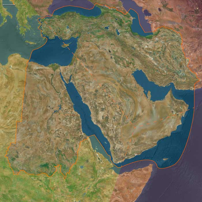
The Near and Middle East (49,293 – 28,578 BCE): Upper Pleistocene I — Glacial Corridors, Desert Shelves, and the First Interlinked Worlds
Geographic and Environmental Context
The Near and Middle East during the late Pleistocene formed a continental hinge between Africa, Eurasia, and the Indian Ocean—a convergence of deserts, mountains, and river valleys where small human bands navigated extreme environmental contrasts.
Yet this “region” was, in reality, three adjacent worlds with distinct climatic engines and survival logics:
-
The Near East, anchored by the Nile corridor, Sinai, and Levant, where riverine and coastal refugia offered year-round resources amid surrounding aridity.
-
The Middle East, stretching from Mesopotamia and the Zagros to the Caucasus uplands and the dry Gulf plain, where loess steppes and cave systems sheltered mobile big-game hunters.
-
The Southeast Arabian and South-Arabian world, dominated by desert basins, fog-fed highlands, and episodic monsoon corridors, where human presence ebbed and returned with the pulse of the Indian Ocean climate.
Across these adjoining zones, people were linked less by proximity than by movement—through rivers, wadis, and coastal shelves that alternately connected and isolated them as the ice advanced and retreated.
Climate and Environmental Shifts
Throughout this epoch, the region oscillated between bitter glacial aridity and brief interstadial moistening.
-
In the Near East, the Sahara and Sinai desiccated, but the Nile remained a green thread nourished by equatorial rains.
During wetter pulses, the Levantine corridor sprouted steppe grasses and gazelle herds; during dry phases, settlement contracted to springs and caves. -
In the Middle East, loess steppes spread across the Zagros piedmont and northern Mesopotamia, with snowfields mantling the Caucasus and Alborz.
The Arabian Gulf stood as a vast inland plain—its rivers and marshes forming a new ecosystem connecting Iran, Mesopotamia, and Arabia. -
In Southeast Arabia, Heinrich-type dry pulses brought dune advance and near-desertion, while interstadials revived fog-belts along Dhofar and Hadhramaut, producing grass and browse for gazelle and ibex.
Overall, a cooler, windier, and more unpredictable climate forced human groups to become specialists in mobility and memory, knowing where water might reappear when the rains returned.
Lifeways and Settlement Patterns
Population density remained low, but continuity endured across shifting ecotones.
Small, kin-based forager bands ranged between upland caves, river terraces, and desert wadis, often revisiting the same localities through generations.
-
Along the Nile and Levant, fish, mollusks, and migratory birds supplemented gazelle, wild cattle, and onager hunting.
Seasonal camps lined ancient channels, with longer stays at delta lagoons and spring oases. -
In the Zagros and Caucasus, hunters followed red deer, goat, and wild sheep along snowline meadows, while lowland groups pursued equids and aurochs across the Euphrates terraces.
Caves such as those of the Zagros foothills show repeated winter occupation and hearth reuse. -
On the Arabian and Oman coasts, transient groups exploited shellfish and turtles; inland foragers converged on perennial springs in Dhofar and Hadhramaut during wet cycles.
Most of the peninsula, however, was uninhabitable during glacial peaks.
Each subregion’s rhythm differed: the Nile anchored, the Zagros alternated, the Arabian deserts blinked in and out of habitability. Together, they embodied the pattern that defines this greater world—a mosaic of refugia and corridors, never a uniform whole.
Technology and Material Culture
A shared Upper Pleistocene adaptive toolkit extended from Africa to Iran but took distinct regional forms:
-
In the Levant and Nile corridor, blade and microlithic industries refined hunting efficiency; bone and antler points, grinding stones, and ochre use signaled complex daily life.
-
Across Mesopotamia and the Zagros, chert microblade and burin technologies flourished, suited to composite hafted tools; cave sites show early use of resins and sinew for binding.
-
In Southeast Arabia, simpler flake industries persisted during dry phases, with bursts of innovation in wetter intervals—evidence of intermittent occupation rather than decline.
Throughout the region, personal ornaments—pierced teeth, shell beads, carved bone—reveal exchange and communication across wide distances. Their presence even in the harshest zones implies networks of symbolic kinship spanning deserts and rivers alike.
Movement and Interaction Corridors
Despite their contrasting ecologies, the three worlds were knitted by movement rather than settlement.
-
The Nile–Sinai–Levant corridor remained the principal conduit between Africa and Eurasia, funneling both genes and ideas northward.
-
The Tigris–Euphrates–Zagros axis linked Anatolia and the Caucasus to the Gulf plain and onward to the Iranian plateau.
-
The Arabian coastal rim—especially during wetter interstadials—offered a tenuous maritime pathway from the Red Sea to the Persian Gulf, bridging African and Asian populations.
At times of extreme aridity, these corridors constricted into isolated refugia; during humid pulses, they reopened, forming vast “cultural floodplains” where foragers re-encountered each other after centuries apart.
Cultural and Symbolic Life
Across all three subregions, symbolic behaviors deepened as adaptive anchors in unstable climates.
Ochre burials, engraved bone fragments, and hearth renewals reflect an expanding sense of continuity and belonging to place.
On the Zagros slopes, patterned bone carvings echo those from the Levant and Caucasus, implying shared mythic language across enormous distances.
Coastal shell beads—some traded hundreds of kilometers inland—testify to communication networks that prefigured the long exchange chains of the early Holocene.
Ritual gatherings likely coincided with resource peaks: Nile flood feasts, gazelle drives on the Levantine steppes, or ibex hunts in Dhofar’s fog forests. These periodic convergences maintained social coherence across landscapes that were otherwise scattered and marginal.
Environmental Adaptation and Resilience
The defining trait of the Near and Middle Eastern worlds in this epoch was ecological intelligence—the capacity to read changing water, wind, and animal patterns and adjust routes accordingly.
People mastered the art of seasonal oscillation:
-
shifting between upland and lowland zones with temperature and rainfall;
-
alternating between riverine anchorage and desert passage;
-
relying on both terrestrial game and aquatic protein to stabilize diets.
Through these habits, they transformed one of the planet’s most unstable climatic mosaics into a livable, remembered geography—an early rehearsal of the human resilience that would later sustain agriculture and urbanism here.
Transition Toward the Last Glacial Maximum
By 28,578 BCE, the Near and Middle East had become a web of refugia and corridors whose diversity belied their geographic continuity.
The Nile, Zagros, and Dhofar realms each operated as semi-independent ecological systems—distinct worlds sharing little but the persistence of life itself.
Yet between them flowed knowledge, pigments, and memory: traces of an expanding human presence that connected Africa’s heart to the heart of Asia.
As the ice advanced elsewhere, this region remained humanity’s crucial bridge—a lattice of shifting coasts, mountains, and deserts that would, in the millennia ahead, seed some of the world’s first enduring civilizations.
The Arrival of Early Modern Humans in Eurasia
Homo sapiens sapiens, the same physical type as modern humans, appeared in various regions by at least 50,000 BCE. These Early European Modern Humans (EEMH), formerly known as Cro-Magnon peoples, represent the first anatomically modern humans in Europe.
Migration into Eurasia
- Early modern humans entered Eurasia via the Arabian Peninsula approximately 60,000 years ago.
- One group rapidly settled coastal areas around the Indian Ocean, expanding into South and Southeast Asia.
- Another group migrated north, reaching the steppes of Central Asia and eventually spreading into Europe.
Coexistence with Neanderthals
- Neanderthals and modern humans coexisted across Europe and western Asia for thousands of years.
- Evidence suggests that interactions may have been peaceful, with possible cultural exchanges.
Interbreeding and Genetic Legacy
- Genetic studies indicate that Neanderthals and modern humans interbred occasionally, with non-African populations today carrying traces of Neanderthal DNA.
- However, there is no strong evidence supporting the existence of true Neanderthal-modern hybrids as a distinct population. Instead, interbreeding events were limited, contributing only small genetic fragments to the modern human genome.
The arrival of modern humans in Eurasia marked a significant turning point, eventually leading to the replacement of Neanderthals, though traces of their genetic legacy remain in human populations today.
The Near and Middle East (28,577 – 7,822 BCE): Late Pleistocene–Early Holocene — Warming Shores, Spring Worlds, and Broad-Spectrum Economies
Geographic & Environmental Context
Across the millennia of deglaciation, the Near and Middle East cohered as a chain of water-anchored landscapes:
-
Southeast Arabia—the Dhofar escarpments with khareef fog-forests, the Ḥaḍramawt–Mahra wadi fans, the al-Wusta/Sharqiyah gravel and dune seas, and Socotra’s Hagghier uplands—turned inward to springs and outward to a retreating Aden–Arabian Sea shoreline.
-
The Middle East—Zagros–Upper Mesopotamia, the Tigris–Euphrates corridors, the Caucasus piedmont, Khuzestan/Fars lowlands, and the advancing Gulf shelf—oscillated between pluvial recovery and steppe stress before stabilizing in the Early Holocene.
-
The Near East—the Nile Valley and Delta, Sinai–Negev–Arabah, the southern Levant, western Anatolia’s Aegean littoral, and the Hejaz–Asir–Tihāma—saw drowned shelves, maturing estuaries, and rejuvenated floodplains.
Rising seas re-shaped coasts (Gulf transgression; Aegean embayments), while thawing headwaters revived perennial flow in the great river systems.
Climate & Environmental Shifts
-
Bølling–Allerød (c. 14.7–12.9 ka): Warmer, wetter conditions expanded Zagros gallery woods and Caucasus belts; Ḥaḍramawt/Dhofar wadis ran strong; Nile floods strengthened; Aegean and Gulf coasts grew more productive.
-
Younger Dryas (12.9–11.7 ka): Cooler, drier snapback: steppe spread across Upper Mesopotamia, wadis intermittently failed in SE Arabia, Nile discharge weakened; foragers pivoted to resilient wetland/coastal patches.
-
Early Holocene (post-11.7 ka): Sustained warmth and more reliable monsoons/westerlies: Zagros springs and Tigris–Euphrates marsh–riparian mosaics stabilized; Dhofar fog-forests rebounded; Nile and Aegean floodplains/estuaries matured as the Gulf flooded landward.
Subsistence & Settlement
A triad of broad-spectrum adaptations converged on semi-sedentary water nodes:
-
Southeast Arabia: Seasonal hamlets clustered at springheads and lagoon margins; diets paired gazelle–oryx–ibex with fish, shellfish, turtles, and mangrove resources. Inland rounds gathered fruits/nuts and hunted in the Mahra/Wusta belts; Socotra remained a wooded outpost likely without permanent settlement.
-
Middle East (Zagros–Upper Mesopotamia–Caucasus–Gulf rim): Spring-terrace camps and riparian hamlets exploited gazelle, onager, boar, riverine fish/mollusks, and seeds, acorns, pistachio/almond. In the Early Holocene, some groups tethered wild caprines, edging toward management on Zagros slopes; marsh fishing/waterfowling intensified in the lower Tigris–Euphrates as the Gulf advanced.
-
Near East (Nile–Levant–Aegean–Hejaz/Tihāma): Nile communities deepened fish–fowl–reed economies; Levantine and Aegean foragers harvested shellfish and nearshore fish alongside deer/boar; Red Sea shorelines with relict mangroves supported intermittent foraging.
Settlement was nodal and recurrent—springs, levees, dune spurs, and lagoon bars accruing hearths, pits, and cemeteries across centuries.
Technology & Material Culture
-
Microlithic bladelet/geometrics dominated hunting kits; hafted composite points and resins common.
-
Grinding stones, mortars/querns for nuts/seeds spread widely; bone harpoons/fish gorges, net weights, basketry, and ropework underpinned marsh/estuary fisheries.
-
Ground-stone tools rose late; incipient pottery appeared by the end of the period on the northern Iranian/Caspian and Anatolian fringes, initially for boiling and storage.
-
Early dugouts/rafts and reed craft likely on Nile backwaters and sheltered lagoons; cabotage along Aegean/Gulf/Arabian rims feasible during stable seasons.
Movement & Interaction Corridors
-
Zagros passes (Kermanshah–Khuzestan) funneled goods/people between uplands and Khuzestan plains; Karkheh–Karun–Shatt al-Arab backwaters linked to the Upper Gulf.
-
Caucasus Kura–Araxes fans connected highlands to Iranian forelands.
-
Ḥaḍramawt–Mahra–Dhofar wadis stitched coast and interior; short maritime hops likely reached the Horn of Africa.
-
The Nile remained the subregion’s master axis; Aegean island-hops and Red Sea shore lanes tied capes and wadi mouths.
These intertwined routes provided redundancy: when wadis failed or steppe widened, marsh, lagoon, and coast supplied calories and salt.
Cultural & Symbolic Expressions
-
Ochre burials and river/spring offerings recur from Zagros to the Nile; house-based ritual—hearth deposits, ancestor interments, stone slab markers—emerged in semi-sedentary camps.
-
Petroglyphs on Dhofar/Haima desert margins and Zagros outcrops (caprids, equids, processions) may root in these horizons.
-
Shell terraces and levee mounds served as feasting grounds and mnemonic landmarks, formalizing access to water and fisheries.
Environmental Adaptation & Resilience
A shared risk-spreading grammar took shape:
-
Dietary breadth + storage (dried meat/fish, nut pastes) buffered Younger Dryas shocks.
-
Flexible rounds (wetland–upland–coast) tracked shifting isohyets and resource pulses.
-
Proximity to springs/marshes anchored overwintering; early caprine tethering and focused seed processing foreshadowed managed food webs.
-
Lagoon/marsh anchoring during arid pulses sustained semi-sedentism without agriculture.
Long-Term Significance
By 7,822 BCE, the Near and Middle East had become a water-anchored, semi-sedentary world: mapped wadi networks in SE Arabia; spring-terrace and marsh hamlets in Zagros–Mesopotamia edging toward herd and seed management; and Nile–Aegean–Red Sea littorals refining wetland and coastal economies.
These intertwined traditions—grinding and storage, spring/levee fidelity, caprine protomanagement, marsh and lagoon fisheries, and seasonal cabotage—constituted the operating code from which the region’s first Neolithic cultivation and herding communities would soon crystallize.
Southeast Arabia (28,577 – 7,822 BCE) Upper Pleistocene II — Deglaciation, Coastal Productivity, and Wadi Networks
Geographic and Environmental Context
Southeast Arabia covers the southern and eastern margins of the Arabian Peninsula:-
Eastern Yemen (Hadhramaut, eastern Aden interior, al-Mahra).
-
Southern Oman (Dhofar Highlands with the khareef monsoon, al-Wusta gravel plains, Sharqiyah Desert fringes).
-
The Empty Quarter (Rubʿ al-Khālī) margins in adjoining Saudi territory.
-
The offshore island of Socotra in the Arabian Sea.
-
Anchors: Wādī Ḥaḍramawt–Shibam–Tarim, Dhofar escarpments (Ẓafār/Al-Balīd, Mirbat), al-Mahra dunes, al-Wusta plains, Sharqiyah sands, Socotra’s Hagghier Mountains and dragon’s-blood groves.
-
As glaciers melted, sea level rose; Gulf of Aden–Arabian Sea coasts retreated inland.
-
Hadhramaut wadis deepened; Dhofar fog-forests fluctuated with monsoon strength.
Climate & Environmental Shifts
-
Bølling–Allerød warming (14,700–12,900 BCE): lush monsoons, wadis flowed, upland belts expanded.
-
Younger Dryas (12,900–11,700 BCE): renewed aridity, wadis dried, dune advance.
-
Early Holocene (after 11,700 BCE): warm stable monsoon, reliable khareef in Dhofar.
Subsistence & Settlement
-
Broad-spectrum foragers: hunting gazelle, oryx, ibex; intensified fishing and shellfish harvests during wet phases.
-
Seasonal hamlets along wadis and coastal terraces, abandoned in dry pulses.
-
Socotra: rich woodlands sustained seabirds and goats, but permanent human settlement is still unlikely.
Technology & Material Culture
-
Bladelet industries matured; ground-stone tools appeared late.
-
Fish gorges, shell scrapers, net weights.
-
Basketry and rope-making inferred from toolkits.
Movement & Interaction Corridors
-
Hadhramaut–Mahra wadis critical wet-phase corridors.
-
Coastal cabotage feasible during stable periods; possible short-haul to Red Sea Horn.
Cultural & Symbolic Expressions
-
Ritual feasting likely at perennial springs.
-
Petroglyphs in Dhofar/Haima desert margins may trace back to these horizons.
Environmental Adaptation & Resilience
-
Flexible settlement and diet shifts buffered against Younger Dryas drought.
Transition
By 7,822 BCE, foragers had mapped wadi networks and sustained a dual economy of coast + upland.