Eastern Southeast Europe
Related Events
Filter results
Showing 10 events out of 2787 total
The Great Crossroads, one of the twelve divisions of the globe, is centered on Eurasia, with its northernmost extent meeting Northern Oceania and The Atlantic World at the North Pole. This vast region excludes the eastern, western, and southern extremities of the Eurasian landmass, which spans a significant portion of the Earth's surface.
The Ural Mountains, running approximately north to south, serve as the traditional boundary between Europe and Asia, as well as between Russia proper and Siberia.
For the purposes of this framework, The Great Crossroads includes Mongolia; western China, including Xinjiang and the Tibetan Plateau; the northern half of the Indian subcontinent; Afghanistan; the Iranian Plateau; Mesopotamia; eastern Arabia; the northern Levant; northeastern Cyprus; western and southwestern Anatolia; the Caucasus; Eastern Europe; Siberia; the Eastern Balkans; Eastern Scandinavia; the Baltic Sea basin; and Middle Europe.
- The southwestern boundary runs diagonally from south-central Germany, through the eastern Alps, the Balkans, and western Asia, terminating in the southern third of the Arabian Peninsula in the vast desert known as the Rub’ al Khali.
- The southern boundary divides South India from North India, following the generally recognized demarcation that includes the Narmada River, and separates the Indian Ocean-facing southeastern Arabian coast from the Persian Gulf-focused eastern Arabia.
- The southeastern boundary runs diagonally from the Bay of Bengal, following India’s border with Myanmar, marking the division between South Asia and both Southeast Asia and Eastern Asia.
Narrow results by searching for a word or phrase or select from one or more of a dozen filters.
The fearsome cave bear (Ursus spelaeus) likely became extinct around 27,800 years ago, according to recent fossil reassessments.
Rather than a single cause, a combination of factors is believed to have led to its extinction. While overhunting by humans has largely been dismissed—since human populations at the time were too small to pose a significant threat—evidence suggests that cave bears and humans may have competed for shelter, particularly in caves.
Mitochondrial DNA research indicates that the cave bear's genetic decline began long before its extinction, ruling out climate change-induced habitat loss as the direct cause. However, a recent DNA study suggests that cave bear populations started declining around 50,000 years ago, coinciding with an increase in human populations.
Unlike its close relative, the brown bear, the cave bear was highly dependent on a vegetarian diet, making it less adaptable to environmental changes. Additionally, evidence suggests that cave bears exclusively used caves for hibernation, unlike brown bears, which could hibernate in thickets or other natural shelters. This specialized hibernation behavior likely contributed to high winter mortality when suitable caves were unavailable.
As human populations gradually expanded, both Neanderthals and anatomically modern humans increasingly occupied caves as living quarters, reducing the availability of essential hibernation sites for cave bears. Over time, this competition for shelter may have contributed to their gradual extinction.
Interestingly, cave bears are rarely depicted in prehistoric cave paintings, leading some researchers to speculate that human hunters may have avoided them, or that their habitat preferences simply did not overlap with early human settlements.
The rapid expansion of anatomically modern humans out of Africa, beginning around 60,000 years ago, appears to coincide with the development of new stone tool-making techniques.
These innovations, which define the Upper Paleolithic period, distinguish the stone tool culture of Homo sapiens sapiens from the previously similar technologies of Neanderthals and other archaic human groups.
Key advancements include:
- The production of long, narrow flake tools, known as blades, which could be fashioned into a variety of specialized tools,
- The emergence of bone and ivory artifacts, and
- The eventual development of clothing, often sewn together and adorned with beads.
These technological advancements likely played a crucial role in the success and adaptability of early modern humans as they spread across new environments.
Cultural practices associated with modern humans—such as the careful burial of the dead, the creation of elaborate cave art, and the decoration of everyday objects—emerge during this period, reflecting an increasing sense of ritual, symbolism, and aesthetic expression.
The development of stone tools appears to have progressed in gradual steps until around 50,000 to 40,000 years ago.
Each successive Homo species—from H. habilis to H. ergaster to H. neanderthalensis—began at a higher technological level than its predecessor. However, once a phase began, further innovation remained slow, reflecting a culturally conservative approach to tool-making.
Around 50,000 BP, however, modern human culture began to evolve at a significantly faster pace. While Neanderthal populations typically displayed little variation in their tool-making techniques, the Cro-Magnon immigrants introduced increasingly refined and specialized flint tools, such as knives, blades, and skimmers.
Additionally, Cro-Magnons expanded beyond stone, pioneering the use of bone tools, marking a major advancement in prehistoric technology.
Modern human culture begins to evolve at an accelerated pace, marking a significant shift in behavior and innovation.
Some anthropologists, notably Jared Diamond, author of The Third Chimpanzee, describe this period as a "Great Leap Forward." During this time, modern humans adopt new cultural and technological practices, including:
- Burying their dead, often with grave goods, suggesting ritual or symbolic thought,
- Crafting clothing from hides, improving survival in colder climates,
- Developing advanced hunting techniques, such as trapping pits or driving animals off cliffs, and
- Creating cave paintings and other forms of artistic expression.
As human culture advances, different populations begin to introduce novelty into existing technologies. Unlike earlier hominins, modern humans show regional variations in artifacts such as fish hooks, buttons, and bone needles, demonstrating a previously unseen diversity of tools and personal items.
Anthropologists identify several key markers of modern human behavior, including:
- Tool specialization,
- Adornment with jewelry and symbolic imagery (such as cave drawings),
- Organized living spaces,
- Elaborate rituals, including burials with grave gifts,
- Exploration of harsh or previously uninhabited environments, and
- The development of barter trade networks.
Debate continues over whether these advancements were the result of a sudden cognitive "revolution"—sometimes called "the big bang of human consciousness"—or whether they emerged through a more gradual evolutionary process.
Migrants from Central Asia and the Middle East are believed to have colonized Europe, moving northwestward over time.
By the time anatomically modern humans first enter Europe, Neanderthals are already well-established in the region. The question of whether these two populations interbred remains a subject of ongoing debate.
Evidence suggests that modern humans and Neanderthals coexisted in various regions, including the Iberian Peninsula and the Middle East, where interbreeding may have contributed Neanderthal genes to early Paleolithic Europeans and, ultimately, to modern European populations.
Regardless of whether interbreeding occurred, it is generally believed that early human populations took refuge in hypothetical Ice Age shelters, later repopulating Europe as the glaciers receded—forming the ancestral foundation of present-day European populations.
An alternative theory proposes that modern Europeans primarily descend from Neolithic populations originating in the Middle East, whose migrations into Europe are well documented.
The debate over the origins of Europeans has often been framed as a question of cultural diffusion versus demic diffusion.
Both archaeological and genetic evidence strongly support demic diffusion—the idea that a population spread from the Middle East over the last 12,000 years, gradually replacing or assimilating earlier groups.
However, some researchers have challenged this view using the genetic concept of Time to Most Recent Common Ancestor (TMRCA). This approach has been used to argue in favor of cultural diffusion, suggesting that technological and cultural advancements spread without significant population movement.
The debate remains ongoing, with scholars examining the complex interplay between migration, gene flow, and cultural exchange in shaping Europe's early populations.
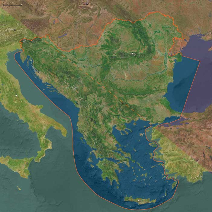
Southeast Europe (49,293 – 28,578 BCE): Upper Pleistocene I — Ice, Karst, and River Corridors at the Crossroads of Continents
Geographic and Environmental Context
During the height of the last glacial cycle, Southeast Europe formed one of the great hinge zones of Eurasia — the meeting ground between the Danubian steppe, the Adriatic–Aegean coastlines, and the mountainous Balkans.
Yet, as elsewhere in The Twelve Worlds, the region was less a single landscape than a set of semi-independent natural worlds, linked more by movement than by unity.
-
To the northeast, Eastern Southeast Europe—the Lower Danube Plain, Iron Gates, and Dobruja uplands—lay exposed to continental winds, forming a periglacial frontier that looked northward toward the loess plains of Central Europe.
-
To the southwest, Western Southeast Europe—the Adriatic–Ionian karst belt of Croatia, Bosnia, Albania, and Greece—was milder, fractured, and coastal: a refuge of caves and cliffs, connected culturally to Italy and the Mediterranean basins.
-
Between them rose the mountain heartland—the Balkans and Rhodopes, dissected by deep valleys that acted alternately as barriers and conduits depending on the severity of the cold.
Across these contrasting worlds, glacial winds, ice-fed rivers, and karstic refuges structured human movement and memory, binding the Danube corridor to the Adriatic shores through a web of seasonal passages and symbolic ties.
Climate and Environmental Shifts
Southeast Europe lay directly in the path of the shifting polar front.
The Last Glacial Maximum brought cold, dry, and windy conditions, with strong seasonality and extensive loess accumulation across northern plains.
-
In Eastern Southeast Europe, steppe–tundra spread across the Danube Plain and the Carpathian forelands, interrupted by gallery forests along meltwater streams.
-
In the Adriatic karst, temperatures were less extreme; precipitation fell as winter snow or spring rain, feeding caves and limestone springs that formed oases in an otherwise barren landscape.
-
Along the Aegean, fluctuating sea level—often 80–100 m lower than today—exposed a vast coastal shelf that joined many of the present islands to the mainland, widening foraging zones but also reshaping coastlines.
Brief interstadials punctuated the long cold: short-lived warm pulses allowed grasses, shrubs, and forests to return, giving temporary abundance to river valleys before the next advance of ice and dust reset the system.
Lifeways and Settlement Patterns
Human presence across these worlds was thin yet persistent, adapted to extreme variability through mobility and ecological flexibility.
-
In Eastern Southeast Europe, small forager bands camped along Danube terraces and loess promontories, targeting migratory herds of horse, reindeer, and bison. The Iron Gates gorges offered ice-free winter refugia where the river cut through the Carpathian front, concentrating fish and game.
-
In Western Southeast Europe, foragers relied on a dual economy of hunting and coastal gathering. Sheltered karst caves and rockshelters in Istria, Dalmatia, and Epirus served as seasonal bases; coastal plains—now submerged—provided shellfish, seabirds, and tunny during warmer intervals.
-
In the interior highlands, upland valleys hosted seasonal hunting camps that followed red deer and ibex herds between lower forest patches and mountain snowline pastures.
These adaptive patterns were neither isolated nor synchronous. Eastern groups followed the rhythms of continental steppe migrations, while western and southern groups synchronized their calendars with Mediterranean currents and the pulse of spring rains. The region as a whole operated as a gradient of survival strategies, not a unified system.
Technology and Material Culture
A broadly shared Upper Paleolithic tradition linked the region’s foragers to the larger European world, yet each subregion expressed it differently.
-
Eastern Southeast Europe developed rich blade and microblade industries, suited to big-game hunting and hide working. Caves and loess sites yielded burins, endscrapers, and bone points, often associated with hearth features and ochre-stained sediments.
-
Western Southeast Europe maintained similar toolkits but diversified them with marine shell ornaments, amber beads, and small engraved stones — signs of symbolic elaboration likely tied to seasonal aggregation in coastal refugia.
-
Across the mountains, tailored clothing, portable fire kits, and hafted composite tools show that people carried both technology and tradition across ecozones.
Ochre use was widespread, and burials — when found — display the same symbolic care evident from the Franco-Cantabrian to the Don: red pigment, ornamentation, and deliberate positioning within the landscape.
Movement and Interaction Corridors
Geography and ice dictated movement.
Three principal corridors connected the subregions and extended the region’s reach:
-
The Danube–Morava–Vardar Axis linked the northern plains to the Aegean world, allowing fauna, people, and ideas to flow between the steppe and the Mediterranean.
-
The Adriatic Shelf—exposed during glacial lowstands—served as a seasonal migration plain and coastal highway, connecting Dalmatia, Apulia, and the Ionian shores.
-
The Carpathian–Balkan Passes provided east–west transit between river and coast, facilitating the diffusion of stone, amber, and ornament styles.
Through these corridors, Southeast Europe remained in dialogue with its neighbors: the Danube steppe with Central Europe, the Adriatic karst with Italy, and the Aegean margin with Anatolia. It was a hinge, not a border.
Cultural and Symbolic Expressions
Symbolic and ritual behaviors reveal both unity and divergence.
Caves from Istria to Thrace bear evidence of ochre use, ornament caches, and ritual hearths. Portable engravings and figurines—sometimes human, sometimes hybrid—echo the mythic grammar shared across the Ice Age world.
The Iron Gates gorges, already by this period, began to serve as persistent aggregation zones, revisited for millennia thereafter.
In coastal karst, burial and habitation often blended: caves doubled as both dwellings and ancestral repositories, rooting communities in cyclical patterns of return.
Environmental Adaptation and Resilience
Survival depended on versatility.
Populations cycled between open steppe hunting in cold phases and riverine or coastal specialization in milder interludes.
Their success rested on mobility across ecozones, knowledge of migratory game and fish cycles, and symbolic practices that sustained social cohesion in times of isolation.
Fire, clothing, and social networks proved as vital as tools.
Transition Toward the Last Glacial Maximum
By 28,578 BCE, Southeast Europe stood poised between two worlds:
to the north, the continental ice; to the south, the emerging temperate refugia of the Mediterranean.
Its three subregions—Danubian steppe, Adriatic karst, and Aegean–Balkan corridor—remained largely independent, yet continually braided by exchange and migration.
In this interplay lay the region’s enduring pattern: a chain of distinct ecological theaters linked more strongly to their counterparts in neighboring regions than to one another.
Southeast Europe thus embodies The Twelve Worlds’ central insight—that regions are not coherent wholes but crossroads of adjacent worlds, each conserving its own rhythm within the shared drama of human persistence at the edge of ice.
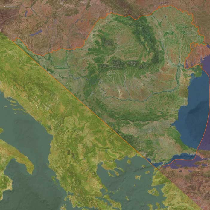
Eastern Southeast Europe (49,293 – 28,578 BCE) Upper Pleistocene I — Ice-Edge Steppes, River Terraces, and Cave Lifeways
Geographic and Environmental Context
Eastern Southeast Europe includes Turkey-in-Europe (Thrace); Greece’s Thrace; Bulgaria (except its southwest); Romania & Moldova; northeastern Serbia; northeastern Croatia; extreme northeastern Bosnia & Herzegovina.
-
Anchors: Lower Danube terraces and loess bluffs, Iron Gates gorges (NE Serbia–Romania), Thracian Plain margins, Dobruja uplands, Carpathian forelands.
-
Periglacial steppe–tundra covered plains; conifer pockets in sheltered valleys; Black Sea level sat far below modern.
Climate & Environmental Shifts
-
Last Glacial Maximum: cold, arid, windy; braided rivers; expanded loess mantles; seasonal ice on the Danube margins.
Subsistence & Settlement
-
Foragers hunted mammoth, bison, horse, reindeer on terrace shoulders; fishing and waterfowl exploited seasonally.
-
Camps in loess promontories and caves/rock shelters; hearths, butchery floors, windbreaks.
Technology & Material Culture
-
Blade–microblade toolkits; burins/scrapers; bone/antler points; eyed needles (tailored furs).
-
Ornaments (pierced teeth, shell); broad ochre use.
Movement & Interaction Corridors
-
Lower Danube trunkway; Iron Gates as winter refugium and crossing; steppe corridors across Dobruja to the Black Sea shelf.
Cultural & Symbolic Expressions
-
Engraved bone/ivory animal imagery; ochred burials imply shared Upper Paleolithic symbolism with the wider Eurasian north.
Environmental Adaptation & Resilience
-
High mobility between river–steppe–shelter niches; layered clothing and fuel caching enabled deep-winter occupation.