Northwest Asia
Related Events
Filter results
Showing 10 events out of 75 total
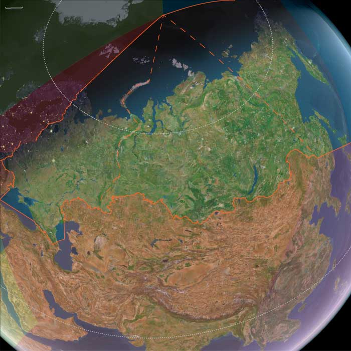
The Great Crossroads, one of the twelve divisions of the globe, is centered on Eurasia, with its northernmost extent meeting Northern Oceania and The Atlantic World at the North Pole. This vast region excludes the eastern, western, and southern extremities of the Eurasian landmass, which spans a significant portion of the Earth's surface.
The Ural Mountains, running approximately north to south, serve as the traditional boundary between Europe and Asia, as well as between Russia proper and Siberia.
For the purposes of this framework, The Great Crossroads includes Mongolia; western China, including Xinjiang and the Tibetan Plateau; the northern half of the Indian subcontinent; Afghanistan; the Iranian Plateau; Mesopotamia; eastern Arabia; the northern Levant; northeastern Cyprus; western and southwestern Anatolia; the Caucasus; Eastern Europe; Siberia; the Eastern Balkans; Eastern Scandinavia; the Baltic Sea basin; and Middle Europe.
- The southwestern boundary runs diagonally from south-central Germany, through the eastern Alps, the Balkans, and western Asia, terminating in the southern third of the Arabian Peninsula in the vast desert known as the Rub’ al Khali.
- The southern boundary divides South India from North India, following the generally recognized demarcation that includes the Narmada River, and separates the Indian Ocean-facing southeastern Arabian coast from the Persian Gulf-focused eastern Arabia.
- The southeastern boundary runs diagonally from the Bay of Bengal, following India’s border with Myanmar, marking the division between South Asia and both Southeast Asia and Eastern Asia.
Narrow results by searching for a word or phrase or select from one or more of a dozen filters.
Northeastern Eurasia (49,293 – 28,578 BCE): Upper Pleistocene I — Steppe, Ice, and the Making of the Northern Corridor
Geographic and Environmental Context
During the late Pleistocene, Northeastern Eurasia extended from the Ural Mountains to the Pacific, encompassing the mammoth-steppe plains of East Europe and Western Siberia, the Altai–Yenisei uplands, and the Amur–Okhotsk–Bering frontier of Northeast Asia.
It was not a single region but a triadic system of worlds:
-
East Europe, the western steppe edge, framed by the Don, Dnieper, and Oka valleys — a land of loess terraces and braided rivers supporting dense megafaunal herds.
-
Northwest Asia, the Siberian interior, from the Urals through the Ob–Irtysh–Yenisei corridor to the Altai, where glacial basins and intermontane valleys served as refugia amid vast permafrost plains.
-
Northeast Asia, the Pacific rim and Beringian shelf, where tundra-steppe met coastal polynyas, bridging the continents long before human migration reached the New World.
Across these subregions, the environment graded from continental aridity in the west to maritime cold along the Pacific — a spectrum of adaptation that tied Eurasia together along its northern rim.
Climate and Environmental Shifts
The interval encompassed alternating Dansgaard–Oeschger warmings and Heinrich cold pulses leading into the Last Glacial Maximum.
-
In East Europe, permafrost advanced to the Dnieper and Don basins; vegetation alternated between steppe grassland and dwarf-shrub tundra.
-
In Northwest Asia, continental cold and aridity dominated; the Ob and Yenisei braided into unstable channels; loess and dust storms swept the forelands of the Urals and Altai.
-
In Northeast Asia, cold was tempered by oceanic moisture. Ice-edge upwellings in the Okhotsk and Bering seas sustained rich marine ecosystems, even as inland basins froze.
Periodic interstadial thaws re-greened the valleys, drawing herds northward and humans with them; stadials drove retreat to riverine refugia.
The result was a dynamic equilibrium of expansion and contraction rather than a single glacial standstill.
Lifeways and Settlement Patterns
All three worlds supported high-latitude foraging economies built on mobility, storage, and memory of place.
-
In East Europe, loess-terrace camps overlooked reindeer and mammoth migration corridors. Semi-recurrent bases at Kostenki, Sungir, and along the Dnieper combined hunting, butchery, and craft production.
-
In Northwest Asia, the Altai foothills and Minusinsk Basin hosted recurrent winter shelters, while open Ob–Yenisei valleys served for summer mammoth and bison hunts.
-
In Northeast Asia, river-mouth camps and coastal flats supported dual economies of inland big-game and maritime sealing and fishing. Seasonal movements linked river confluences, upland passes, and shelf-edge hunting grounds.
Each subregion achieved local stability through broad prey portfolios and cyclical mobility tuned to glacial rhythms.
Technology and Material Culture
A shared Upper Paleolithic technological grammar spanned the entire northern corridor:
-
Blade and microblade industries, adapted to portable composite weapons, formed the technological backbone from the Don to the Anadyr.
-
Bone, antler, and ivory were fashioned into points, awls, harpoons, and eyed needles — evidence for tailored fur clothing and cold-weather dwellings.
-
Obsidian sources in the Altai and Kamchatka and flint quarries in the Don basin anchored far-flung exchange networks.
-
Personal adornment — beads of tooth, ivory, shell, and amber — and ochre burials underscored enduring symbolic systems linking the Eurasian north to the rest of the Upper Paleolithic world.
The breadth of these parallels reveals not isolation but interoperability across extreme distance.
Movement and Interaction Corridors
Northeastern Eurasia was defined by movement — the continual negotiation between ice, water, and wind.
-
The Steppe–River Network: Don–Volga–Ural–Ob–Yenisei channels allowed seasonal following of herds and diffusion of tool types and ornaments.
-
The Altai–Mongolia Crossroads: A mountainous hinge connecting western and eastern populations, where genetic and cultural exchanges mixed Siberian and East Asian lineages.
-
The Amur–Okhotsk–Bering Rim: Shelf and river corridors provided both overland and coastal pathways toward Beringia, the eventual gateway to the Americas.
These arteries made the northern fringe not an end of settlement but a conveyor of innovation and populationbetween continents.
Cultural and Symbolic Expressions
Symbolic behavior mirrored subsistence breadth.
Engraved bones, ivory figurines, and ochred burials appear in all three subregions, expressing a shared spiritual engagement with animals and ancestors.
Altai and Don sites yield portable art and ivory figures, while the Amur and Lena valleys preserve carved bone and antler motifs of reindeer and mammoth.
Fire-ringed hearths and ritual hearth renewals suggest continuity of place and group identity across generations.
In these expressions, the northern peoples joined the global Upper Paleolithic symbolic sphere while imprinting it with an Arctic signature of endurance and cyclical return.
Environmental Adaptation and Resilience
Resilience depended on technological insulation, ecological diversity, and social connectivity.
Fur clothing, hide shelters, and stored fuel allowed wintering at 60–70° N; seasonal migration between coast, river, and plateau distributed risk; and wide alliance networks permitted exchange of mates, materials, and knowledge across immense ranges.
When one valley froze, another thawed — and people already knew the way.
Genetic and Linguistic Legacy
Populations rooted in this corridor carried the genetic foundations of later Arctic and Beringian peoples.
From East Europe through the Altai to the Amur, gene flow linked Eurasia’s west and east, seeding the ancestry of the First Americans and shaping linguistic substrates later echoed in circumpolar families.
Northeastern Eurasia thus became the cradle of the circumpolar continuum — a trans-Beringian cultural ecology that would persist for tens of millennia.
Transition Toward the Last Glacial Maximum
By 28,578 BCE, ice sheets and permafrost deepened, narrowing the habitable band to river valleys and steppe oases.
Yet humans remained throughout, their territories contracting but not vanishing.
The East European plains anchored the west, the Altai–Yenisei belt sustained the interior, and the Amur–Bering coast reached outward toward a new continent.
Northeastern Eurasia therefore stands as a model of The Twelve Worlds principle: its subregions were self-contained in ecology yet outward-looking in connection, bound less by shared geography than by the long, unbroken thread of movement — the first great northern highway of the human story.
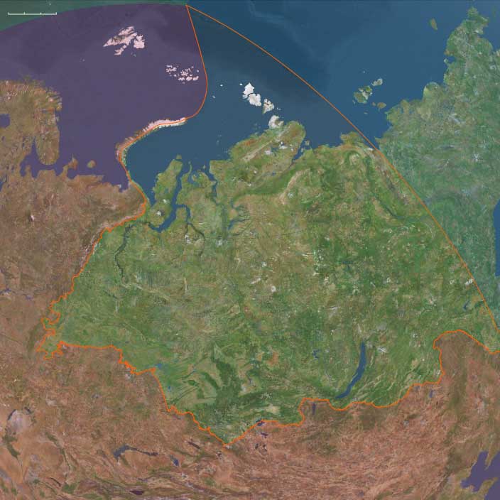
Northwest Asia (49,293 – 28,578 BCE): Upper Pleistocene I — Mammoth-Steppe Foragers and Ural–Altai Corridors
Geographic and Environmental Context
Northwest Asia includes the lands from the Ural Mountains east to ~130°E, encompassing Western and Central Siberia.
-
Anchors: Ob–Irtysh steppe valleys, Altai foothills, Yenisei terraces, Ural forelands.
-
Sea levels lower, steppe–tundra extended widely across western Siberia; glaciers capped the Altai ranges.
Climate & Environmental Shifts
-
Last Glacial Maximum: cold, arid; permafrost deep; loess plains extended; river channels braided, unstable.
-
Steppe–tundra mosaics supported megafauna.
Subsistence & Settlement
-
Foragers hunted mammoth, woolly rhinoceros, bison, horse, and reindeer; riverside camps exploited fish and waterfowl.
-
Rock shelters in Altai and Minusinsk served as recurrent winter bases.
Technology & Material Culture
-
Blade–microblade industries, burins, scrapers; bone/antler points; eyed needles for tailored clothing.
-
Portable ornaments: drilled teeth, ivory beads, ochre.
Movement & Interaction Corridors
-
Ob–Irtysh–Yenisei rivers structured mobility; Altai passes linked to Mongolia; Ural forelands tied to Eastern Europe.
Cultural & Symbolic Expressions
-
Cave art in the Altai (e.g., figurative engravings); ochred burials with personal ornaments; animal figurines.
Environmental Adaptation & Resilience
-
High mobility between steppe–river–shelter zones buffered harsh winters; tailored hide clothing ensured survival.
Siberia has paleontological significance, as it contains bodies of prehistoric animals from the Pleistocene Epoch, preserved in ice or in permafrost.
Specimens of Goldfuss cave lion cubs, Yuka the mammoth and another woolly mammoth from Oymyakon, a woolly rhinoceros from the Kolyma, and bison and horses from Yukagir have been found.
One of the largest-known volcanic events of the last 251 million years of Earth's geological history formed the Siberian Traps.
Volcanic activity continued here for a million years and some scientists consider it a possible cause of the "Great Dying" about 250 million years ago, estimated to have killed 90% of species existing at the time.
Northeastern Eurasia (28,577 – 7,822 BCE): Late Pleistocene–Early Holocene — Beringian Migrations, Salmon Economies, and the First Pottery Traditions
Geographic & Environmental Context
At the end of the Ice Age, Northeastern Eurasia—stretching from the Urals to the Pacific Rim—was a vast, deglaciating world of river corridors, boreal forests, and emerging coasts. It included three key cultural–ecological spheres:
-
Northwest Asia — the Ob–Irtysh–Yenisei heartlands, Altai piedmont lakes, and Minusinsk Basin, bounded by the Ural Mountains to the west. Here, deglaciation produced pluvial lake systems, and forest belts climbed into the Altai foothills.
-
East Europe — from the Dnieper–Don steppe–forest margins to the Upper Volga–Oka and Pripet wetlands, a corridor of interlinked rivers and pluvial basins supporting rich postglacial foraging.
-
Northeast Asia — the Amur and Ussuri basins, the Sea of Okhotsk littoral, Sakhalin and the Kuril–Hokkaidō arc, Kamchatka, and the Chukchi Peninsula—a maritime–riverine realm where early Holocene foragers developed salmon economies and pottery traditions under the warming Pacific westerlies.
Together these subregions formed a continuous arc of adaptation spanning tundra, taiga, and coast—an evolutionary laboratory for the technologies and traditions that would later circle the entire North Pacific.
Climate & Environmental Shifts
-
Bølling–Allerød (14,700–12,900 BCE): Rapid warming and higher precipitation expanded boreal forests and intensified riverine productivity across Eurasia’s north. Salmon runs strengthened in the Amur and Okhotsk drainages; pluvial lakes filled the Altai basins.
-
Younger Dryas (12,900–11,700 BCE): A temporary cold–dry reversal restored steppe and tundra, constraining forests to valleys; lake levels fell; inland mobility increased.
-
Early Holocene (after 11,700 BCE): Stable warmth and sustained moisture drove forest advance (pine, larch, birch) and high lake stands; sea levels rose along the Okhotsk and Bering coasts, flooding older plains and establishing modern shorelines.
These oscillations forged adaptable forager systems able to pivot between large-game mobility and aquatic specialization.
Subsistence & Settlement
Across the northern tier, lifeways diversified and semi-sedentism began to take root:
-
Northwest Asia:
Elk, reindeer, beaver, and fish formed broad-spectrum diets. Lakeside camps in the Altai and Minusinsk basins became seasonal home bases, while Ob–Yenisei channels hosted canoe or raft mobility. Forest nuts and berries expanded plant food options in warm phases. -
East Europe:
Along the Dnieper, Don, and Upper Volga, foragers targeted elk, red deer, horse, and beaver, exploiting riverine fish and waterfowl. Repeated occupations at lake outlets and confluences reflect increasing site permanence and food storage. -
Northeast Asia:
The Amur–Okhotsk region pioneered salmon-based economies, anchoring early Holocene villages at river confluences and estuarine terraces. Coasts provided seal, shellfish, seabirds, and seaweeds, while inland foragers pursued elk and musk deer. Winter sea-ice hunting alternated with summer canoe travel along the Sakhalin–Kuril–Hokkaidō chain.
This mosaic of economies—lake fishers, river hunters, and sealers—reflected the continent’s growing ecological diversity.
Technology & Material Culture
Innovation was continuous and regionally distinctive:
-
Microblade technology persisted across all subregions, with refined hafting systems for composite projectiles.
-
Bone and antler harpoons, toggling points, and gorges evolved for intensive fishing and sealing.
-
Ground-stone adzes and chisels appeared, enabling woodworking and boat construction.
-
Early pottery, first along the Lower Amur and Ussuri basins (c. 15,000–13,000 BCE), spread across the Russian Far East—among the world’s earliest ceramic traditions—used for boiling fish, storing oils, and processing nuts.
-
Slate knives and grindstones at Okhotsk and Amur sites show specialized craft economies.
-
Personal ornaments in amber, shell, and ivory continued, while sewing kits with eyed needles and sinew thread supported tailored, waterproof clothing.
These toolkits established the technological template for later northern and Pacific Rim foragers.
Movement & Interaction Corridors
-
Ob–Irtysh–Yenisei river systems funneled movement north–south, linking the steppe with the taiga and tundra.
-
Altai and Ural passes maintained east–west contact with Central Asia and Europe.
-
Dnieper–Volga–Oka networks merged the European forest-steppe into the greater Eurasian exchange field.
-
In the Far East, the Amur–Sungari–Zeya–Okhotsk corridor unified interior and coast, while the Sakhalin–Kuril–Hokkaidō arc allowed short-hop voyaging.
-
Across the Bering Strait, fluctuating sea levels intermittently connected Chukotka and Alaska, maintaining Beringian gene flow and cultural exchange.
These conduits supported both biological and technological diffusion at a continental scale.
Cultural & Symbolic Expressions
-
Ochre burials with ornamented clothing and ivory or antler goods reflect deep symbolic continuity from the Upper Paleolithic.
-
Petroglyphs and engravings in the Altai and Minusinsk basins, and later in Kamchatka, depict large animals, waterbirds, and solar motifs.
-
Amur basin figurines and carved marine-mammal and fish effigies attest to ritualized relationships with food species.
-
In the Far East, early evidence of first-salmon and bear-rite traditions foreshadows later Ainu and Okhotsk ceremonialism.
Across all subregions, water and game remained the core of spirituality, connecting people to cyclical abundance and ancestral landscapes.
Environmental Adaptation & Resilience
Foragers across Northeastern Eurasia met environmental volatility with creative versatility:
-
Zonal mobility (taiga–tundra–coast) and multi-season storage (dried meat, smoked fish, rendered oils) stabilized food supply.
-
Boat and ice technologies extended reach across seasons.
-
Broad-spectrum diets cushioned against climatic downturns.
-
Flexible dwellings and social alliances allowed fission and fusion as resources shifted.
-
Memory landscapes—engraved rocks, ritual mounds, named rivers—preserved continuity through spatial change.
Genetic and Linguistic Legacy
The Beringian population standstill during the Late Glacial created a deep ancestral pool for both Paleo-Inuit and First American lineages, while reciprocal migration reconnected Chukchi, Kamchatkan, and Amur populations after sea-level rise.
These long-lived networks seeded circum-Pacific cultural parallels in salmon ritual, dog-traction, maritime hunting, and composite toolkits, forming the northern backbone of later trans-Pacific cultural continuity.
Long-Term Significance
By 7,822 BCE, Northeastern Eurasia had become one of the world’s great centers of forager innovation:
-
Northwest Asia’s pluvial lakes fostered early semi-sedentism and the first rock art of Siberia.
-
East Europe’s river–lake foragers stabilized broad-spectrum economies bridging steppe and forest.
-
Northeast Asia’s salmon-rich coasts and early pottery traditions created the technological and ritual matrix that would radiate across the North Pacific.
This continental synthesis of aquatic resource mastery, ceramic innovation, and long-range mobility defined the emerging Holocene north—a zone where people and landscape adapted together through water, ice, and memory.
Northwest Asia (28,577 – 7,822 BCE): Upper Pleistocene II — Deglaciation, Forest Advance, and Lake Highstands
Geographic and Environmental Context
Northwest Asia includes the lands from the Ural Mountains east to ~130°E, encompassing Western and Central Siberia.
-
Anchors: Ob floodplains, Altai piedmont lakes, Yenisei–Minusinsk Basin, Ural passes.
-
Deglaciation created large pluvial lakes in the Altai and Minusinsk depressions.
Climate & Environmental Shifts
-
Bølling–Allerød warming improved rainfall and forest belts; Younger Dryas reversed conditions briefly; Early Holocene warmth stabilized environments.
Subsistence & Settlement
-
Diets diversified: elk, reindeer, beaver, fish, nuts, and berries.
-
Semi-sedentary lakeside camps emerged around pluvial lakes and Ob–Yenisei channels.
Technology & Material Culture
-
Microblade complexes persisted; ground-stone tools for plant processing began; bone harpoons and fishing gear.
-
Ornaments in antler, amber, and imported shells.
Movement & Interaction Corridors
-
Ob–Irtysh trunklines enabled north–south mobility; Altai passes linked into Central Asia; Ural passes tied to European plains.
Cultural & Symbolic Expressions
-
Ritual deposits at lakesides; ochre burials continued; petroglyphs began in Minusinsk–Altai zones.
Environmental Adaptation & Resilience
-
Broad-spectrum foraging buffered climatic reversals; canoe precursors and rafts likely aided mobility on large lakes.
Mitochondrial haplogroups A, B, and G originated fifty thousand years ago, and the bearers subsequently colonized Siberia, Korea and Japan, by thirty five thousand years ago.
Parts of these populations migrate to North America.
The Woolly Rhinoceros: A Survivor of the Ice Age
The woolly rhinoceros (Coelodonta antiquitatis), a dominant species across Europe and Asia during the Pleistocene epoch, was one of the last and most specialized members of the Pleistocene rhinoceros lineage. It thrived throughout the last glacial period, adapted to the frigid landscapes of the steppe-tundra biome that spanned the Palearctic ecozone.
Anatomy and Adaptations
- The woolly rhinoceros maintained a conservative body plan, similar to the earliest rhinoceroses from the late Eocene, while evolving specific adaptations to cold climates.
- Stocky limbs and thick, woolly fur helped it survive the harsh steppe-tundra conditions.
- Size and Build:
- Length: 3 to 3.8 meters (10 to 12.5 feet)
- Weight: 2 to 3 tons on average
- Height: Up to 2 meters (6.5 feet) at the shoulder
- Horns and Skull:
- Two keratin-based horns, with the larger anterior horn measuring up to 2 feet.
- A smaller horn positioned between the eyes.
- Other Features:
- Small ears, short, thick legs, and a robust, stocky body.
- Cave paintings suggest some individuals may have had a dark band across their midsection, though this is not universal.
Fossil Evidence and Artistic Depictions
The external appearance of the woolly rhinoceros is known from:
- Frozen mummified remains recovered from Siberia, providing detailed anatomical information.
- Cave paintings created by early humans, though some depictions remain uncertain in terms of species identification.
Extinction and Discovery of a Complete Specimen
- The woolly rhinoceros went extinct around the end of the Pleistocene, likely due to a combination of climate change and human hunting pressure.
- Until the 20th century, its physical form was known only from prehistoric cave drawings.
- In a remarkable discovery, a completely preserved specimen (missing only fur and hooves) was found in a tar pit in Starunia, Poland.
- This specimen, an adult female, is now housed at the Polish Academy of Sciences' Museum of Natural History in Kraków, offering an invaluable glimpse into the anatomy and preservation of this Ice Age giant.
The woolly rhinoceros remains one of the most iconic Ice Age mammals, demonstrating how megafaunal species adapted to glacial conditions before ultimately succumbing to environmental and ecological pressures.
Northeastern Eurasia (7,821 – 6,094 BCE): Early Holocene — Salmon Rivers, Pottery Frontiers, and Forest–Sea Corridors
Geographic & Environmental Context
From the Upper Volga–Oka and Dnieper–Pripet belts across the Ob–Irtysh–Yenisei to the Amur–Ussuri and the Okhotsk–Bering rim (Sakhalin, Kurils, Kamchatka, Chukchi, northern Hokkaidō), Northeastern Eurasia formed a continuous world of taiga, big rivers, and drowned estuaries. Sea level rise reshaped river mouths into productive bays and tidal flats; inland, lake chains and marshlands multiplied along stabilized watersheds.
Climate & Environmental Shifts
The Holocene thermal optimum brought warmer, wetter, and more even seasonality.
-
Taiga expansion (birch–pine–spruce) advanced north; mixed forests with hazel spread south.
-
Rivers (Volga, Dnieper, Ob, Yenisei, Amur) ran full but steady; estuaries and kelp-lined nearshore waters boomed.
-
Rising seas drowned river mouths, creating ideal passages for anadromous salmon and shellfish-rich flats.
These conditions favored semi-sedentary clustering at confluences, terraces, and tidal margins.
Subsistence & Settlement
A pan-regional broad-spectrum, storage-oriented foraging system matured:
-
East Europe (Upper Volga–Oka, Dnieper, Upper Dvina, Pripet): semi-sedentary river villages with pit-houses focused on sturgeon/pike, elk/boar, hazelnuts, and berries; net-weirs and fish fences anchored seasonal peaks.
-
Northwest Asia (Ob–Irtysh–Yenisei, Altai–Minusinsk): riverine hamlets hunted elk, reindeer, boar; salmon and sturgeon fisheries underwrote wintering; hearth clusters and storage pits marked long occupation.
-
Northeast Asia (Lower/Middle Amur–Ussuri, Okhotsk littoral, Sakhalin–Kurils–Hokkaidō, Kamchatka, Chukchi): salmon-focused semi-sedentism at confluences and tidal flats; smoke-drying and oil rendering produced high-calorie stores; broad-spectrum rounds added elk/reindeer, waterfowl, intertidal shellfish, and seasonal pinnipeds.
Across the span, households returned to the same terraces, bars, and headlands, building place-memory landscapes suited to storage and exchange.
Technology & Material Culture
This was the first great pottery horizon of the north, paired with refined fishing and woodcraft:
-
Early ceramics (7th millennium BCE onward): fiber-/plant- or grit-tempered jars spread in the Upper Volga–Oka, Ob–Yenisei, and Lower Amur, used for boiling fish/meat, fat rendering, and storage; soot-blackened cookpots are typical in the Amur basin.
-
Ground-stone adzes/axes drove canoe- and house-carpentry; composite harpoons, barbed bone hooks, gorges, net sinkers/floats, and stake-weirs scaled mass capture.
-
Personal ornaments of shell, amber, antler, and drilled teeth traveled widely; ochre accompanied burials.
Movement & Interaction Corridors
Waterways made a braided superhighway:
-
Volga–Oka–Dnieper–Dvina canoe circuits linked taiga, marsh, and lake belts; portages stitched watersheds and spread pottery styles.
-
Ob–Irtysh–Yenisei integrated western and central Siberia; the Ural corridor connected taiga foragers with the forest-steppe of Europe.
-
Amur–Sungari tied interior to coast; short-hop voyaging along Sakhalin–Kurils–Hokkaidō moved shell, stone, and ideas; over-ice travel on inner bays persisted in winter.
These lanes provided redundancy—if a salmon run failed locally, neighboring reaches or coastal banks supplied substitutes.
Cultural & Symbolic Expressions
A river-and-animal cosmology left vivid traces:
-
Rock art fields (Minusinsk, Tomsk, Karelia–Alta–Finland) depict elk, fish, boats, hunters, and ritual poses.
-
First-salmon rites are inferred in patterned discard and special hearths; bear and sea-mammal treatments suggest respect for “animal masters.”
-
Cemeteries with ochre, antler and stone grave goods, and—in the northeast—pots in burials formalized ancestry tied to landing places and weirs.
Waterfront mounds and shell/bone-rich zones functioned as ancestral monuments.
Environmental Adaptation & Resilience
Resilience rested on storage + mobility + multi-habitat rounds:
-
Smoke-dried fish, rendered oils, roasted nuts/berries, and cached meats carried camps through winter.
-
River–coast–upland scheduling diversified risk across salmon runs, waterfowl peaks, reindeer/elk migrations, and shellfish seasons.
-
Weir and landing-place tenure, reinforced by ritual, regulated pressure on key stocks and limited conflict.
Long-Term Significance
By 6,094 BCE, Northeastern Eurasia had consolidated into a storage-rich taiga and salmon civilization without agriculture—large, long-lived villages on river terraces and tidal flats; early pottery embedded in daily subsistence; and canoe/ice corridors knitting thousands of kilometers.
These habits—fat economies, ceramic storage, engineered fisheries, and shrine-marked tenure—prepared the ground for larger pit-house villages, denser coastal networks, and, later, steppe–taiga exchanges that would link this northern world to Eurasia at large.
Northwest Asia (7,821 – 6,094 BCE): Early Holocene — Taiga Mosaics and Riverine Foragers
Geographic and Environmental Context
Northwest Asia includes the lands from the Ural Mountains east to ~130°E, encompassing Western and Central Siberia.
-
Anchors: Ob–Tomsk terraces, Altai–Minusinsk Basin, Middle Yenisei, Ural foreland forests.
-
Boreal forests expanded, dominated by birch–pine–spruce.
Climate & Environmental Shifts
-
Early Holocene thermal optimum: warmer, wetter, stable river flows.
Subsistence & Settlement
-
Hunting elk, reindeer, and boar; fishing salmon and sturgeon in the Ob–Yenisei.
-
Seasonal riverine villages with pit-houses and hearth clusters.
Technology & Material Culture
-
Ground-stone adzes, axes; bone harpoons and fish gorges; pottery appears early in Siberia (c. 7th millennium BCE).
-
Nets and weirs for fishing.
Movement & Interaction Corridors
-
Ob–Irtysh–Yenisei integrated taiga foragers; Ural corridor linked to forest-steppe of Europe.
Cultural & Symbolic Expressions
-
First petroglyph traditions (Minusinsk, Tomsk basins) depict elk, fish, hunters.
-
Burials with red ochre, antler, stone tools.
Environmental Adaptation & Resilience
-
Broad-spectrum foraging with early pottery storage stabilized taiga subsistence.