Northeast Europe
Related Events
Filter results
Showing 10 events out of 1564 total
The Great Crossroads, one of the twelve divisions of the globe, is centered on Eurasia, with its northernmost extent meeting Northern Oceania and The Atlantic World at the North Pole. This vast region excludes the eastern, western, and southern extremities of the Eurasian landmass, which spans a significant portion of the Earth's surface.
The Ural Mountains, running approximately north to south, serve as the traditional boundary between Europe and Asia, as well as between Russia proper and Siberia.
For the purposes of this framework, The Great Crossroads includes Mongolia; western China, including Xinjiang and the Tibetan Plateau; the northern half of the Indian subcontinent; Afghanistan; the Iranian Plateau; Mesopotamia; eastern Arabia; the northern Levant; northeastern Cyprus; western and southwestern Anatolia; the Caucasus; Eastern Europe; Siberia; the Eastern Balkans; Eastern Scandinavia; the Baltic Sea basin; and Middle Europe.
- The southwestern boundary runs diagonally from south-central Germany, through the eastern Alps, the Balkans, and western Asia, terminating in the southern third of the Arabian Peninsula in the vast desert known as the Rub’ al Khali.
- The southern boundary divides South India from North India, following the generally recognized demarcation that includes the Narmada River, and separates the Indian Ocean-facing southeastern Arabian coast from the Persian Gulf-focused eastern Arabia.
- The southeastern boundary runs diagonally from the Bay of Bengal, following India’s border with Myanmar, marking the division between South Asia and both Southeast Asia and Eastern Asia.
Narrow results by searching for a word or phrase or select from one or more of a dozen filters.
The Moderns are taller, more slender, and less muscular than the Neanderthals, with whom they share—perhaps uneasily—the Earth.
Though their brains are smaller in overall size, they are heavier in the forebrain, a difference that may allow for more abstract thought and the development of complex speech.
Yet, the inner world of the Neanderthals remains a mystery—no one knows the depths of their thoughts or how they truly expressed them.
During this period, Neanderthals are gradually being displaced as modern humans expand into Europe.
The slow pace of human migration into Europe suggests that Homo sapiens and Neanderthals may have been in continuous competition for territory over an extended period.
Neanderthals, with their larger, more robust frames, were likely physically stronger than modern Homo sapiens. Having inhabited Europe for over 200,000 years, they were also better adapted to cold climates, giving them a potential survival advantage in harsh Ice Age conditions.
North Europe (49,293 – 28,578 BCE): Upper Pleistocene I — Ice Margins, Steppe Corridors, and the Fragmented North
Geographic and Environmental Context
By the late Pleistocene, North Europe stood as the northern hinge of the continent, divided by the reach of the great Fennoscandian Ice Sheet. It was not one region, but two distinct glacial worlds:
-
Northeast Europe, the Baltic–Fennoscandian frontier, stretched from the southern edges of the Scandinavian ice dome through the Baltic States and the Gulf of Finland to the upper Volga and Lake Ladoga basin.
It was a zone of ice, loess, and meltwater—a cold periglacial steppe, where life clung to the southern coastal margins of what would later become the Baltic Sea. -
Northwest Europe, by contrast, encompassed the Atlantic–North Sea plains and the ice-free slopes of western Norway, Denmark, and the British uplands.
This was the world of the Doggerland plains and fjord coasts: broad, wind-swept, seasonally productive, and comparatively mild under Atlantic influence.
Between these worlds lay no continuous population but a moving frontier of life, expanding and contracting with each climatic pulse. What united them was not contiguity, but parallel adaptation to the ice’s edge.
Climate and Environmental Shifts
The climate of North Europe oscillated violently under Dansgaard–Oeschger and Heinrich rhythms.
-
In the northeast, the Fennoscandian ice sheet repeatedly advanced southward, covering most of Scandinavia and suppressing forest growth. South of the ice, tundra–steppe vegetation dominated the Baltic plain, punctuated by short interstadial bursts of birch and pine. Proglacial lakes formed and drained in cycles, carving channels that became the future Daugava, Nemunas, and Vistula systems.
-
In the northwest, the Atlantic moderated extremes but not instability. During interstadials, reindeer, horse, and bison grazed the grasslands of Doggerland and Britain; in stadials, cold desert conditions prevailed, dunes marched eastward, and ice tongues advanced down the Norwegian fjords.
Together these cycles forged a landscape of radical seasonality: half the year locked in permafrost, half a surge of meltwater, light, and migration. Human existence followed those rhythms.
Lifeways and Settlement Patterns
Human occupation was confined to the ice-free southern and western rims, forming two contrasting ecological economies.
-
In Northeast Europe, foragers lived on the margins of the ice, exploiting reindeer and horse herds that migrated along meltwater valleys. Small, mobile bands camped on loess ridges above floodplains, using hearth clusters, windbreaks, and stone pavements to endure the cold. Fish and waterfowl supplemented diets in thaw seasons. Settlement was seasonal and opportunistic, retreating south during harsh stadials.
-
In Northwest Europe, the exposed Doggerland plains and the English–Dutch coasts supported larger, more stable hunting territories. Reindeer and red deer herds were followed across open river valleys, while coastal groups took fish, shellfish, and seals in warmer phases. Western Norway’s fjords and Scottish seaboard provided rich marine refugia for small wintering groups.
Each subregion reflected a different axis of survival: the continental steppe pulse in the northeast, and the coastal–estuarine cycle in the northwest.
Technology and Material Culture
Despite distance and climatic severity, material traditions reveal a common technological ancestry within the European Upper Paleolithic, adapted locally to ice-edge conditions.
-
Blade and microblade toolkits of high-quality flint and chert were dominant; burins, endscrapers, and tanged or backed points typify both regions.
-
Bone and antler industries produced points, harpoons, and eyed needles for fur clothing—essential for Arctic survival.
-
Amber ornaments in the Baltic south and perforated shells and teeth in the Atlantic west suggest shared symbolic vocabularies, even as materials differed.
-
Ochre, used in burials and personal decoration, marked continuity with symbolic practices farther south.
Innovation was not in form but in durability and cold-weather adaptation: composite weapons, insulated clothing, and shelters of hide and bone that allowed habitation closer to the ice than ever before.
Movement and Interaction Corridors
Even under glacial constraint, movement tied both halves of North Europe to larger continental systems.
-
In the northeast, the Daugava–Nemunas–Vistula corridors served as arterial routes for herds and hunters alike, linking the Baltic steppe to Central Europe’s loess plains and the Dnieper frontier beyond.
-
In the northwest, the Doggerland lowlands formed a vast connective plain between Britain and the continent, facilitating seasonal aggregation and the circulation of stone, pigment, and ornament styles.
-
Fjord coasts of Norway and Scotland, intermittently ice-free, provided maritime corridors—perhaps the earliest footholds of a North Atlantic tradition that would re-emerge after the glacial maximum.
These corridors made the North less an isolated periphery than a mobile bridge—its people the edge-dwellers of Europe’s greatest ecological frontier.
Cultural and Symbolic Expressions
Though few sites preserve rich art, what survives suggests enduring symbolic continuity with Upper Paleolithic Europe.
Engraved bone plaquettes and ivory animal motifs—reindeer, elk, mammoth—appear along the Baltic fringe; ochred burials and personal ornaments echo the spiritual grammar of the south.
In the west, decorated antlers, amber beads, and ochre scatters mark ritualized reuse of certain campsites.
These traces imply memory landscapes, where people returned generation after generation to the same terraces or shelters, layering presence with pigment, ornament, and fire.
Environmental Adaptation and Resilience
Adaptation in North Europe meant mastering instability.
-
Northeast populations relied on extraordinary mobility and foresight, tracking migratory prey over hundreds of kilometers and caching tools and fuel along known routes.
-
Northwest populations practiced diversification—alternating terrestrial hunting with aquatic and coastal harvesting when game retreated.
-
Both depended on technological insulation (tailored clothing, deep hearths, semi-subterranean shelters) and social insulation (information and alliance networks across the steppe).
Survival was thus collective, predicated on knowledge exchange and ritual reaffirmation more than any single resource.
Transition Toward the Last Glacial Maximum
By 28,578 BCE, North Europe stood at the threshold of the Last Glacial Maximum:
-
Northeast Europe contracted into a narrow, frozen corridor between ice and steppe, its human populations withdrawing south toward the Dnieper and Carpathian refugia.
-
Northwest Europe persisted longer, its coastal shelves and mild fjords offering intermittent refuges as the North Sea basin froze and permafrost advanced.
The two subregions never coalesced into a single cultural sphere; each looked outward—to Central Europe, to the Atlantic, to the open steppe—for kin and connection.
Thus the northern world epitomized The Twelve Worlds’ central insight: that regions fracture under stress, yet remain coherent through exchange, their strength lying not in unity but in the fluid movement of people and meaning along the shifting edge of ice.
Northeast Europe
(49,293 – 28,578 BCE) Upper Pleistocene I — Ice Sheets, Mammoth-Steppe, and Southern Refuge Zones
Geographic and Environmental Context
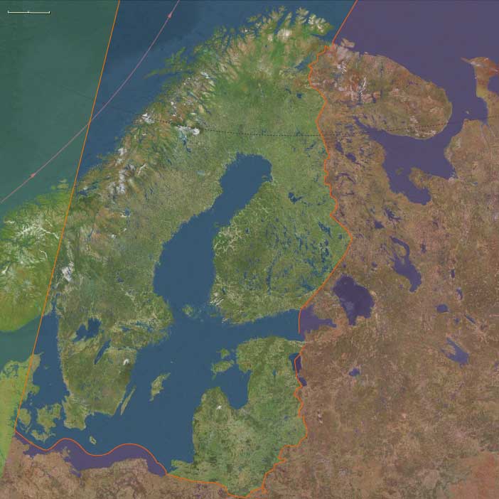
Northeast Europe includes Sweden, Finland, the Baltic States (Estonia, Latvia, Lithuania), eastern Denmark (including Copenhagen, Zealand, Bornholm), eastern Norway (including Oslo), and the Russian enclave of Kalingrad.
-
Anchors: Lake Mälaren–Uppland (Sweden), Lake Vänern–Oslofjord, Aland Islands–Gulf of Bothnia, Lake Ladoga–Karelia–Volga headwaters, Daugava–Nemunas corridors (Baltic States), Kaliningrad–Curonian/Neman delta.
-
Northern Fennoscandia buried under the Fennoscandian ice sheet.
-
Ice-free corridors survived along the southern Baltic coast (Lithuania, Latvia, Kaliningrad) and adjacent Poland.
-
Exposed Baltic shelf plains stretched far north due to sea-level fall.
Climate & Environmental Shifts
-
Last Glacial Maximum: cold, dry, glacial; tundra–steppe south of the ice sheet; sea level ~100 m below modern.
-
Glacial meltwaters carved proglacial channels feeding southward into the Vistula–Daugava systems.
Subsistence & Settlement
-
Human presence restricted to southern refugia: reindeer–horse hunters in Lithuania–Latvia–Kaliningradmargins.
-
Seasonal reindeer drives along ice-edge valleys; fish and waterfowl secondary.
Technology & Material Culture
-
Blade–microblade industries; bone/antler points; personal ornaments (pierced teeth, amber beads); ochre burials persisted.
Movement & Interaction Corridors
-
Daugava–Nemunas–Vistula river systems provided migration corridors; steppe–tundra routes linked to Central/Eastern Europe.
Cultural & Symbolic Expressions
-
Portable engravings of elk, reindeer, mammoth motifs; ochred burials signal continuity with wider European Upper Paleolithic.
North Europe (28,577 – 7,822 BCE): Late Pleistocene–Early Holocene — Deglaciation, Doggerland, and the Rise of the Baltic Seas
Geographic & Environmental Context
During the final millennia of the Ice Age, North Europe was a landscape of retreating glaciers, rising seas, and advancing forests.
Two interdependent subregions defined this transformation:
-
Northeast Europe — the Baltic–Fennoscandian zone, including southern Sweden, Finland, the Baltic States (Estonia, Latvia, Lithuania), eastern Denmark, eastern Norway, and the Ladoga–Karelia–Kaliningrad corridor. Deglaciation sculpted a system of proglacial lakes, notably the Baltic Ice Lake and later the Ancylus Lake, which filled the basins left by retreating ice sheets. Meltwater rivers like the Daugava–Nemunas served as northward corridors for people and animals.
-
Northwest Europe — comprising the British Isles, western Norway, western Denmark, and the exposed North Sea plains known as Doggerland. These connected Britain to the European mainland until sea-level rise in the early Holocene submerged them. River valleys such as the Rhine–Thames–Elbe drained the plains, while the deepening fjords of Norway became centers of emerging coastal productivity.
Together these regions formed a vast transitional world—part tundra, part forest, part floodplain—bridging the glacial and postglacial epochs.
Climate & Environmental Shifts
-
Last Glacial Maximum (26,500–19,000 BCE): Thick ice sheets blanketed Scandinavia and the Baltic basin; tundra–steppe dominated the North Sea lowlands; strong westerlies and low precipitation produced cold, arid conditions.
-
Bølling–Allerød (14,700–12,900 BCE): Rapid warming melted ice and flooded valleys; birch and pine colonized newly deglaciated terrain; reindeer and horse herds moved north.
-
Younger Dryas (12,900–11,700 BCE): A sharp cold relapse restored steppe–tundra in lowlands and slowed forest spread; foragers retreated to coastal and riverine refugia.
-
Early Holocene (after 11,700 BCE): Long-term climatic stability allowed oak, hazel, and elm forests to spread across lowlands; the Baltic Ice Lake evolved into the Ancylus Lake and later the brackish Littorina Sea; Doggerland slowly disappeared beneath rising seas.
Subsistence & Settlement
As the ice withdrew, pioneer foragers followed the meltwater front northward:
-
Northeast Europe: Early camps formed along proglacial lakes and meltwater valleys, initially focused on reindeer hunting. By the Early Holocene, diets diversified to include elk, beaver, fish, and waterfowl, signaling a shift toward broad-spectrum economies. Lakeside and riverside camps became increasingly permanent, especially around Karelia, Lake Ladoga, and the Baltic shore.
-
Northwest Europe: The Doggerland plains supported reindeer, horse, and aurochs hunters during the Late Glacial, who later adapted to riverine and coastal resources as the plains flooded. Norwegian fjord communities developed early specializations in seal, fish, and seabird harvesting, while groups along the Channel and North Sea coasts gathered shellfish and netted migratory fish.
These mobile but regionally anchored foragers balanced inland game rounds with predictable aquatic resources.
Technology & Material Culture
-
Lithic industries: Late Magdalenian and Hamburgian–Ahrensburgian complexes in the west, and Swiderian and Kunda traditions in the east, employed microblades, tanged points, and backed tools suited for reindeer and elk hunting.
-
Fishing and woodworking: Bone and antler harpoons, gorges, and fish weirs show intensified aquatic specialization; woodworking tools like adzes and chisels appear with forest expansion.
-
Early pottery arose by the end of this epoch in the Upper Volga–Karelia region, spreading westward as one of Eurasia’s earliest ceramic traditions.
-
Adornment and art: Amber, tooth, and bone pendants, engraved plaquettes, and ochre burials continued the symbolic practices of Upper Paleolithic Europe.
Movement & Interaction Corridors
-
Daugava–Nemunas–Pregolya waterways connected the Baltic basin to the eastern European plains.
-
The Ladoga–Onega–Karelia–Finnmark chain served as a migration route for both humans and fauna into postglacial Finland and Sweden.
-
The Doggerland river system linked the Rhine, Thames, and Elbe, creating a shared cultural landscape before submergence.
-
Norwegian fjords and North Sea coasts enabled early maritime foraging and the first use of small watercraft.
-
Western Denmark and eastern England served as cross-channel contact zones until the sea finally severed them around 8,000–7,500 BCE.
These routes knitted together a continent of thawing valleys and emergent coasts into a single interactive frontier.
Cultural & Symbolic Expressions
-
Rock engravings on glacial outcrops in Karelia and northern Norway depicted reindeer, elk, fish, and boats, recording both ecological dependence and spiritual continuity.
-
Ochre burials with antler and tooth ornaments across Denmark, Doggerland, and the Baltic reveal shared ritual traditions.
-
Lakeside offerings—antlers, fish bones, ochre, and carved figurines—point to ceremonies honoring water spirits or ancestors tied to place.
-
Portable ornamentation and engraved tools reinforced social identity and long-distance connection across forager bands.
Environmental Adaptation & Resilience
-
Seasonal mobility tracked reindeer herds north in spring and followed fish and waterfowl south in fall.
-
Mixed terrestrial–aquatic diets provided stability as ecosystems transformed.
-
Flexible dwellings, clothing, and watercraft enabled survival in both tundra and forest.
-
Storage and preservation of fish, meat, and nuts reduced risk during winter scarcity.
-
Persistent symbolic marking of key foraging grounds reinforced social memory in shifting environments.
Long-Term Significance
By 7,822 BCE, North Europe had fully transitioned from glacial tundra to a world of forests, rivers, and rising seas:
-
In the northeast, the Baltic basin had become a vast freshwater landscape supporting semi-sedentary fishers and elk hunters.
-
In the northwest, Doggerland was vanishing beneath the sea as its inhabitants migrated to the British Isles and Norwegian fjords, where maritime traditions took root.
These centuries of adaptation forged the ecological intelligence and technological foundations of the European north—mobility paired with memory, foraging fused with water mastery, and landscapes rendered sacred through continuity of use—that would define the Mesolithic and set the stage for later Neolithic expansions.
Northeast Europe (28,577 – 7,822 BCE) Upper Pleistocene II — Deglaciation, Pioneer Foragers, and Baltic Lakes
Geographic and Environmental Context
Northeast Europe includes Sweden, Finland, the Baltic States (Estonia, Latvia, Lithuania), eastern Denmark (including Copenhagen, Zealand, Bornholm), eastern Norway (including Oslo), and the Russian enclave of Kalingrad.
-
Anchors: Southern Baltic coast, Daugava–Nemunas valleys, Latvia–Estonia proglacial lakes, Lake Ladoga basin.
-
Retreating glaciers created vast proglacial lakes (Baltic Ice Lake, Ancylus Lake).
Climate & Environmental Shifts
-
Bølling–Allerød: warmer, moister; birch–pine colonized deglaciated areas.
-
Younger Dryas: return to cold, steppe-like conditions with periglacial dunes.
-
Early Holocene: ice sheet retreat; forests spread.
Subsistence & Settlement
-
Pioneer foragers followed reindeer north as ice retreated; seasonal hunting camps along proglacial lakes.
-
Diets diversified into elk, beaver, fish, and waterfowl by the Early Holocene.
Technology & Material Culture
-
Microblade complexes widespread; early pottery appears in Upper Volga–Karelia, influencing later Northeast Europe.
-
Bone harpoons, fishing gear in lacustrine contexts.
Movement & Interaction Corridors
-
Deglacial corridors via Daugava–Nemunas; Lake Ladoga–Karelia as stepping-stones into Finland–Sweden after ice retreat.
Cultural & Symbolic Expressions
-
Rock engravings on glacial outcrops (Karelia); ritual lakeside deposits with ochre.
The Historical Range and Decline of the European Bison (Wisent)
The lowland European bison (Bison bonasus), also known as the wisent, once roamed extensively across the lowlands of Europe, from the Massif Central in France to the Volga River and the Caucasus. It may have also inhabited parts of Asiatic Russia, though evidence of this remains inconclusive.
Range Decline and Human Impact
- The expansion of human populations led to widespread deforestation, reducing the wisent’s natural habitat.
- As forests were cleared for agriculture and settlements, the bison’s range gradually contracted.
- Hunting pressure further accelerated the species’ decline, as it was prized for meat, hides, and sport.
By the early 20th century, the European bison was on the brink of extinction, surviving only in protected reserves and conservation programs. Today, efforts to reintroduce and conserve the species have been successful in several parts of Europe, though its range remains far more restricted than in prehistoric times.
The culture is named after the village of Ahrensburg, twenty-five kilometers (15.53 miles) northeast of Hamburg in the German state of Schleswig-Holstein, where wooden arrow shafts and clubs have been excavated.
During the ice age, all of Scandinavia was covered by glaciers most of the time, except for the southwestern parts of what we now know as Denmark.
When the ice begins retreating, the barren tundras are soon inhabited by reindeer and elk, and Ahrenburg and Swiderian hunters from the south follow them here to hunt occasionally.
The geography is very different from what we know today.
Sea levels are much lower; the island of Great Britain is connected by a land bridge to mainland Europe and the large area between Great Britain and the Jutlandic peninsula—now beneath the North Sea and known as Doggerland—is inhabited by tribes of hunter-gatherers.