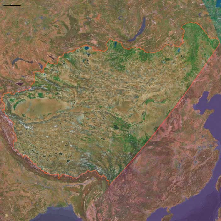
Upper East Asia
Related Events
Filter results
Showing 10 events out of 298 total
The Great Crossroads, one of the twelve divisions of the globe, is centered on Eurasia, with its northernmost extent meeting Northern Oceania and The Atlantic World at the North Pole. This vast region excludes the eastern, western, and southern extremities of the Eurasian landmass, which spans a significant portion of the Earth's surface.
The Ural Mountains, running approximately north to south, serve as the traditional boundary between Europe and Asia, as well as between Russia proper and Siberia.
For the purposes of this framework, The Great Crossroads includes Mongolia; western China, including Xinjiang and the Tibetan Plateau; the northern half of the Indian subcontinent; Afghanistan; the Iranian Plateau; Mesopotamia; eastern Arabia; the northern Levant; northeastern Cyprus; western and southwestern Anatolia; the Caucasus; Eastern Europe; Siberia; the Eastern Balkans; Eastern Scandinavia; the Baltic Sea basin; and Middle Europe.
- The southwestern boundary runs diagonally from south-central Germany, through the eastern Alps, the Balkans, and western Asia, terminating in the southern third of the Arabian Peninsula in the vast desert known as the Rub’ al Khali.
- The southern boundary divides South India from North India, following the generally recognized demarcation that includes the Narmada River, and separates the Indian Ocean-facing southeastern Arabian coast from the Persian Gulf-focused eastern Arabia.
- The southeastern boundary runs diagonally from the Bay of Bengal, following India’s border with Myanmar, marking the division between South Asia and both Southeast Asia and Eastern Asia.
Narrow results by searching for a word or phrase or select from one or more of a dozen filters.
The Moderns are taller, more slender, and less muscular than the Neanderthals, with whom they share—perhaps uneasily—the Earth.
Though their brains are smaller in overall size, they are heavier in the forebrain, a difference that may allow for more abstract thought and the development of complex speech.
Yet, the inner world of the Neanderthals remains a mystery—no one knows the depths of their thoughts or how they truly expressed them.
Upper East Asia (49,293 – 28,578 BCE): Steppe–Taiga Frontiers and Riverine Corridors
Geographic and Environmental Context
-
This region spans high, cold plateaus (Mongolia), riverine lowlands (Amur, Sungari, Liao), and coastal zones along the Sea of Japan/East Sea.
-
During this period, sea levels ~60–90 m lower widened coastal plains in Primorye and narrowed straits between Sakhalin, Hokkaidō, and the mainland.
-
The land bridge between the Korean Peninsula and southwestern Japan was narrower but still a significant barrier, crossed only intermittently.
Climate and Environmental Shifts
-
Dansgaard–Oeschger warm phases brought modest summer warming, allowing expansion of meadow-steppe and scattered forest patches in lowlands.
-
Heinrich stadials were cold and dry, expanding open steppe and tundra across Mongolia and northern Manchuria; permafrost zones advanced southward.
-
Winters were long and severe; summers were short but could support rich grassland growth in river valleys.
-
The Amur basin remained a relatively milder corridor compared to the upland plateaus.
Subsistence and Settlement
-
Steppe foragers hunted wild horse, saiga, gazelle, and red deer; used river valleys for fishing and plant gathering in the warmer months.
-
Forest–edge groups took elk, moose, and boar; collected nuts and berries in interstadials.
-
Seasonal movements followed ungulate migrations, often along river systems.
-
Coastal foragers exploited shellfish, anadromous fish (e.g., salmon runs), and marine mammals in ice-free seasons.
Technology and Material Culture
-
Widespread microblade technology in the north and east, suited to composite hunting weapons for mobile steppe and forest hunting.
-
Larger flake tools persisted in some southern zones alongside blades and scrapers.
-
Stone raw materials included fine-grained chert, jasper, and volcanic rock; obsidian sources in the Russian Far East were already in use.
-
Ochre use is attested in some cave and open-air sites; personal ornaments from bone, tooth, and shell.
Movement and Interaction Corridors
-
Amur and Liao river systems acted as north–south migration and exchange routes, linking taiga and steppe populations.
-
Coastal corridor along the Sea of Japan/East Sea connected Primorye to southern Korea and possibly to the southern Japanese islands during favorable crossings.
-
Mountain passes in the Greater and Lesser Khingan ranges provided east–west movement during milder summers.
Cultural and Symbolic Expressions
-
Beads, pendants, and ochre suggest symbolic life was well developed, possibly linked to group identity and seasonal aggregation.
-
Rock shelters with hearths and artifact scatters indicate repeated occupation during favorable seasons.
Environmental Adaptation and Resilience
-
Seasonal mobility between upland hunting grounds and lowland refugia buffered against extreme winter scarcity.
-
Use of both terrestrial and aquatic resources diversified diets.
-
Clothing and shelter technology adapted to cold conditions was crucial, with microblade points likely used in fur processing.
Toward the Last Glacial Maximum
By 28,578 BCE, Upper East Asian foragers were fully adapted to a cold, highly seasonal environment, combining microblade weaponry, long-distance mobility, and social exchange networks to endure increasingly harsh glacial conditions.
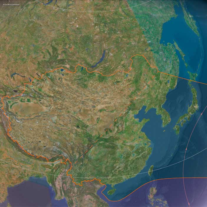
East Asia (49,293 – 28,578 BCE): Upper Pleistocene I — River Plains, Exposed Shelves, and Steppe–Taiga Frontiers
Geographic & Environmental Context
At glacial lowstand (~60–90 m below present), East Asia spanned two interlocking realms that shared people, tools, and seasonal movements:
-
Maritime East Asia: broad exposed shelves along the Yellow Sea, East China Sea, and Taiwan Strait; extended lower courses of the Yangtze, Yellow (Huang He), and Liao formed vast estuarine wetlands far seaward of today’s coasts. Honshu–Shikoku–Kyushu were joined into a single main Japanese island with enlarged lowlands; Taiwan was intermittently land-bridged or separated by narrow straits.
-
Upper East Asia: steppe–taiga mosaics from Mongolia and the Amur–Sungari–Liao basins to Primorye and the Sea of Japan/East Sea rim. Wider coastal plains in Primorye and narrowed straits between Sakhalin–Hokkaidō–the mainland reshaped corridors for game and people.
Together, these lands offered a full spectrum of habitats—river valleys, shelf coasts, temperate forests, taiga, and open steppe—stitched by monsoon rhythms and cold-season winds.
Climate & Environmental Shifts
Glacial climate imposed strong seasonality and pulsed between cooler/drier stadials and warmer/wetter interstadials:
-
Dansgaard–Oeschger warm phases: stronger summer monsoon, broadleaf forest expansion, higher river productivity, and stable estuaries.
-
Heinrich/cold stadials & approach to the LGM: weakened monsoon, steppe and open woodland spread over lowlands; heavier dust flux from inland deserts; longer, colder winters in northern China and Korea.
-
Regional contrast: the Amur basin remained a relatively milder corridor than the Mongolian plateaus; shelf coasts stayed productive even in cool phases.
Subsistence & Settlement
Foragers mastered dual terrestrial–aquatic economies, moving seasonally across coast–river–upland belts:
-
Lowlands & coasts: hunted red deer, sika deer, boar, wild cattle; fished estuaries, tidal flats, and shelf-edge bays; collected shellfish and seaweeds in sheltered embayments.
-
Uplands & interior valleys: pursued sika/red deer, elk/moose, gazelle or wild horse on steppe margins; gathered nuts, fruits, tubers during interstadials.
-
Northern rivers & coasts: targeted anadromous fish (salmon runs) and marine mammals in ice-free seasons.
-
Mobility: regular river-valley⇄upland⇄coastal rounds; winter aggregation near protected river benches or rock shelters; warm-season dispersal to hunt, fish, and collect plant foods.
Technology & Material Culture
Toolkits reflected both cold adaptation and aquatic specialization:
-
Lithics: flake and blade industries across the south; widespread microblade complexes in the north and east for composite weapons suited to mobile hunting. Raw materials ranged from fine chert and quartzite to obsidian in the Russian Far East.
-
Organic tools: bone points, gorges, barbed tips for fish and marine mammals; hide/fiber nets, traps, and probable weirs along major waterways.
-
Processing & craft: grindstones for nuts/seeds, bark- and hide-working; ochre as pigment and adhesive additive; shell and tooth ornaments signaling identity and alliances.
-
Clothing & shelter: tailored furs and layered garments; insulated dwellings and hearths for severe winters.
Movement & Interaction Corridors
-
Shelf-coast routes linked populations along the exposed Yellow/East China Sea margins, easing movement between mainland China, Taiwan, and southern Japan.
-
River corridors—especially the Yangtze and Yellow, and in the north the Amur–Liao—connected interior foragers with estuary fishers and shellfishers, enabling seasonal aggregation and exchange.
-
Strait crossings narrowed between Korea and the Japanese archipelago and between Sakhalin–Hokkaidō–the mainland, allowing occasional maritime passages in favorable windows.
-
Khingan passes and Primorye coast provided east–west and north–south conduits during mild summers.
Cultural & Symbolic Expressions
-
Ornaments: perforated shells and animal teeth, beads, and pendants mark social ties and group identity.
-
Pigment: ochre for body decoration, hide treatment, and ritual.
-
Mark-making: probable early engravings/paint in caves and shelters; structured hearths and curated spaces suggest seasonal aggregation rites tied to monsoon peaks, fish runs, and game migrations.
Environmental Adaptation & Resilience
-
Risk buffering: dual reliance on terrestrial hunting and aquatic foraging mitigated monsoon variability and winter scarcity.
-
Seasonal scheduling: coast/river/upland alternation matched spawning runs, mast pulses, and herd movements.
-
Preservation: drying/smoking of fish and meat, storage of nuts and tubers, and hide processing bridged cold seasons.
-
Habitat flexibility: readiness to pivot between forest refugia, steppe edges, and estuarine flats as climates oscillated.
Toward the Last Glacial Maximum
By 28,578 BCE, East Asian foragers were fully at home in a cold, highly seasonal world—ranging across exposed shelves, great river plains, and steppe–taiga frontiers with microblade weaponry, watercraft-assisted mobility, and wide social networks.
These lifeways—broad-spectrum diets, corridor travel, cold-weather craft, and shared symbolism—formed the durable base from which Early Holocene communities would later develop low-level plant tending (proto-rice in the lower Yangtze, millet in the north) and more permanent coastal settlement as seas rose and forests recovered.
East Asia (28,577 – 7,822 BCE): Late Pleistocene–Early Holocene — Deglaciation, Monsoon Worlds, and the Roots of Cultivation
Geographic & Environmental Context
During the Late Pleistocene and early Holocene, East Asia—stretching from the Yellow Sea and Japanese archipelagos to the Himalayan and Tibetan highlands—underwent one of the most dramatic transformations in the Old World.
At the Last Glacial Maximum (LGM), much of the East China Sea and Yellow Sea were exposed as fertile plains linking the Chinese coast, Korean Peninsula, and parts of southern Japan. Far inland, massive glaciers blanketed the Tibetan Plateau and Altai–Tianshan ranges, feeding pluvial lakes across Mongolia and western China.
As deglaciation advanced, rising seas flooded continental shelves, isolating the Japanese islands, transforming Taiwan into a true island, and creating the estuaries and coastal wetlands that would later anchor early agriculture and fishing communities.
Two major ecological spheres emerged:
-
Maritime East Asia, defined by monsoon-fed rivers, expanding forests, and rich estuarine zones across China, Korea, Japan, and Taiwan.
-
Upper East Asia, encompassing Mongolia, Tibet, Xinjiang, and Qinghai, where grass–steppe mosaics, pluvial lakes, and highland refugia supported resilient forager bands.
Climate & Environmental Shifts
This epoch was marked by alternating climatic pulses that shaped both ecology and human adaptation:
-
Last Glacial Maximum (26,500–19,000 BCE): Cold, dry, and windy; monsoons weakened; northern forests retreated into refugia; grasslands spread across the Loess Plateau and Ordos; glaciers expanded in the Altai and Tibet.
-
Bølling–Allerød Interstadial (14,700–12,900 BCE): Rapid warming; strengthened summer monsoons; forest recovery across East Asia; abundant rainfall filled the Yangtze and Yellow River valleys.
-
Younger Dryas (12,900–11,700 BCE): Return to aridity and cooler temperatures; reduced rainfall and steppe expansion in the north; coastal resource use intensified as inland productivity declined.
-
Early Holocene (after 11,700 BCE): Onset of the modern monsoon regime; rising seas transformed exposed shelves into shallow inland seas (East China, Yellow, and Bohai); lush vegetation and stable hydrology supported population growth and early cultivation.
By 7,800 BCE, climate stability allowed humans to anchor lifeways around dependable wet–dry seasonal cycles—the foundation of later agricultural systems.
Subsistence & Settlement
Maritime East Asia and Upper East Asia pursued parallel but distinct adaptations:
-
Maritime East Asia:
LGM foragers hunted deer, boar, and aurochs, gathered nuts and tubers, and fished rivers and tidal flats. As warming returned, populations expanded into reforested zones and estuarine deltas.
In southern China and the lower Yangtze, low-level food production began—wild rice tending, nut tree management, and millet experimentation in northern river valleys. Along coasts, groups gathered shellfish, seaweed, and crabs, leaving early shell middens in Japan and China.
Cave and rock-shelter settlements—such as Zhoukoudian Upper Cave, Xianrendong, and Okinoshima—mark continuity through climate swings. -
Upper East Asia:
Foragers along the Altai–Gobi and Tibetan margins tracked herds of gazelle, wild horse, yak, and antelope, while exploiting lake-shore fish and reed tubers during interstadial warm phases.
Highland refugia offered stability during glacial pulses, with yak hunting and root-gathering anchoring year-round subsistence. Seasonal camps clustered along Qilian–Kunlun–Hexi Corridor foothills and around Qinghai Lake pluvial basins.
Across the region, mobility combined with familiarity—bands circulated through known landscapes but reoccupied productive locales, a pattern of proto-sedentism tied to rivers and lakes.
Technology & Material Culture
Technological diversification paralleled environmental variety:
-
Stone industries ranged from northern microblades (Mongolia–Manchuria) to southern flake-and-core traditions, both evolving into more specialized forms by the Early Holocene.
-
Grinding stones appeared across the Yellow and Yangtze basins for nut and seed processing.
-
Bone, antler, and shell tools proliferated—fishhooks, harpoons, awls, and ornamental pendants.
-
Early pottery, among the world’s oldest, emerged before 16,000 BCE in southern China and Japan, used for cooking aquatic foods and storage.
-
Ochre pigments, personal ornaments, and incised bone motifs reveal aesthetic continuity and the deepening of ritual expression.
Movement & Interaction Corridors
Changing geography opened and closed human routes:
-
Exposed shelves of the East China and Yellow Seas during the LGM allowed land migration between China, Korea, and Japan.
-
The Yangtze and Yellow River systems acted as major longitudinal corridors for movement, trade, and innovation.
-
The Hexi Corridor connected Central Asia to the Chinese heartlands, while the Altai–Dzungar gates opened toward the Siberian plains.
-
Coastal voyaging likely linked Taiwan, the Ryukyus, and the Chinese mainland, foreshadowing later seafaring cultures.
Together these networks created a continental-maritime exchange field, within which ideas and species circulated long before agriculture.
Cultural & Symbolic Expressions
East Asia’s symbolic life deepened in scale and sophistication:
-
Shell middens and coastal cemeteries in Japan and southern China may represent early territorial markers.
-
Pottery decoration—cord impressions, incisions, and painted motifs—emerged as expressions of identity and ritual belonging.
-
Ochre burials in both coastal and inland zones reflect shared cosmologies of rebirth and continuity.
-
Rock art across the Loess Plateau, Hexi Corridor, and northern steppes depicted animals, hunters, and abstract signs, connecting mountain and plain in shared mythic landscapes.
Environmental Adaptation & Resilience
Resilience arose from mobility, resource diversity, and early niche construction:
-
Alternation between coastal, riverine, and upland habitats allowed for flexible subsistence during climatic instability.
-
Diverse diets—marine, riparian, and forest products—buffered risk.
-
Early plant-tending in the Yangtze and Yellow valleys revealed proto-agricultural adaptation.
-
Seasonal storage, especially in pottery and pits, reduced vulnerability to seasonal shortages.
-
In the highlands, yak and antelope tracking, along with lake fishing, ensured persistence through cold fluctuations.
Long-Term Significance
By 7,822 BCE, East Asia had achieved ecological and cultural equilibrium across its vast range:
-
Maritime East Asia hosted thriving monsoon forests, shell-midden villages, and the first managed cereals.
-
Upper East Asia sustained resilient highland foragers, setting the stage for pastoral and caravan lifeways.
Across both realms, rising seas, stable monsoons, and technological ingenuity forged the pathways to Neolithic transformation.
The foundations of rice and millet cultivation, coastal settlement, and long-distance exchange were already in place—signaling the dawn of East Asia’s enduring agricultural civilizations.
Upper East Asia (28,577–7,822 BCE): Deglaciation, Pluvial Basins, and Highland Refugia
Geographic and Environmental Context
Upper East Asia includes Mongolia, Tibet, and the western highlands of China (Xinjiang, Qinghai, Gansu, Ningxia, NW Sichuan).
Anchors: Altai–Gobi margins, Ordos–Loess Loop, Tarim–Junggar basins, Qinghai–Tibet Plateau (Amdo, Kham), Qilian–Kunlun–Tianshan ranges, Hexi Corridor.
-
Retreat of glaciers in Altai, Qilian, Kunlun; meltwater swelled Tarim, Junggar, Qinghai pluvial lakes.
-
Bølling–Allerød humid surge expanded grass–steppe; Younger Dryas reversed to aridity.
-
Early Holocene warmth and monsoon rebound re-greened basins and plateau margins.
Subsistence & Settlement
-
Foragers occupied lake shores (fish, waterfowl, reed tubers) and steppe fringes (gazelle, wild equids).
-
Plateau refugia provided yak–antelope hunting, marmots, and root-gathering.
-
Rock shelters along Qilian–Kunlun escarpments anchored seasonal camps.
Technology
-
Blade–microblade traditions; bone harpoons; early grindstones.
-
Hide/felt clothing; fire-hearths for winter.
Movement Corridors
-
Hexi Corridor linked Loess to basins.
-
Altai–Dzungar gates opened to Siberia.
-
Koko Nor/Qinghai Lake shores as gathering nodes.
Symbolism
-
Red ochre in burials; stone alignments on ridges; incised bone motifs.
Adaptation
-
Seasonal alternation: pluvial lakes in warm pulses, highland refuges in cold/dry phases.
Transition
By 7,822 BCE, mixed lacustrine–highland strategies underpinned survival, priming pastoral potentials.
Upper East Asia (7,821–6,094 BCE): Early Holocene — Lakefront Hamlets & High-Pasture Hunts
Geographic and Environmental Context
Upper East Asia includes Mongolia, Tibet, and the western highlands of China (Xinjiang, Qinghai, Gansu, Ningxia, NW Sichuan).
Anchors: Altai–Gobi margins, Ordos–Loess Loop, Tarim–Junggar basins, Qinghai–Tibet Plateau (Amdo, Kham), Qilian–Kunlun–Tianshan ranges, Hexi Corridor.
Climate
-
Holocene optimum; Qinghai, Tarim lakes high; alpine meadows verdant
Subsistence & Settlement
-
Semi-sedentary camps on lake terraces; fish, lotus-like rhizomes, antelope.
-
Plateau summer hunts (wild yak, blue sheep); winter in basin shelters.
Technology
-
Ground-stone mortars; microlithic composites; woven mats/nets.
-
Post-built dwellings on lakeshores.
Movement Corridors
-
Hexi–Loess connection; Altai–Dzungar transits; Kukunor pilgrimage/gathering.
Symbolism
-
Petroglyphs of caprids; cairn-offerings at passes; burial mounds with ochre.
Adaptation
-
Stored dried fish; mixed resource portfolios stabilized camps.
Transition
By 6,094 BCE, lakefront “villages” and plateau rounds foreshadowed pastoral–horticultural shifts.
East Asia (7,821 – 6,094 BCE): Early Holocene — Rivers, Seas, and High Pastures in Concert
Geographic & Environmental Context
East Asia in the Early Holocene comprised two interlocking realms:
-
Upper East Asia—the Altai–Gobi margins, Tarim–Junggar basins, Hexi Corridor, and Qinghai–Tibetan Plateau—a highland–basin mosaic of lakefront hamlets and high-pasture hunts.
-
Maritime East Asia—the Yellow and Yangtze lowlands, peninsulas and deltas, Korean south coast, Taiwan, and the Ryukyu arc—a littoral of semi-sedentary villages, shell terraces, and canoe corridors.
Retreating ice and rising seas set both realms into mutually reinforcing stability: lakes high, deltas broad, forests and reefs at maximum Holocene vigor.
Climate & Environmental Shifts
Under the Holocene climatic optimum:
-
Plateau and basin lakes (Qinghai/Kukunor, Tarim, Junggar) were high; alpine meadows were verdant.
-
Monsoons extended north and west, greening the Loess–Ordos rims and feeding mega-deltas downstream.
-
Coastal waters warmed; Kuroshio strengthened along the island arcs.
The result was a continent-to-coast equilibrium that fostered semi-sedentary residence in both upland and littoral zones.
Subsistence & Settlement
A twin-spectrum economy emerged:
-
Uplands and Basins (Upper East Asia): lake-terrace hamlets combined fish, waterfowl, rhizomes, and big-game summer hunts (wild yak, blue sheep), retreating to basin shelters in winter. Ground-stone mortars, microlithic composites, and post-built huts attest to stability and storage (dried fish, cached seeds).
-
Coasts and Deltas (Maritime East Asia): estuary–lagoon villages harvested shellfish, fish, and wetland plants; proto-rice tending and arboriculture began in backswamps; pottery (cord/impressed) spread for boiling and fermenting; dugouts and stake-weirs scaled mass capture.
Across both spheres, settlement was semi-sedentary, clustered at reliable water and provisioning nodes.
Technology & Material Culture
-
Upper East Asia: ground-stone grinders, microlithic weaponry, woven mats and nets; ochre and petroglyph traditions at passes and lakes.
-
Maritime East Asia: ceramics in deltas and islands; ground-stone adzes, bone/shell hooks, net weights; canoe carpentry advances.
Shared elements—cordage, basketry, ornaments—circulated through Hexi–Loess and delta–island exchange belts.
Movement & Interaction Corridors
-
Hexi Corridor & Altai–Dzungar passes linked plateau lake peoples with Loess and northern China, enabling seasonal trade and marriage networks.
-
River highways (Yellow/Yangtze) and island ladders (Taiwan–Ryukyu–Kyushu; Shandong–Korea) tied interior terraces to coasts and coasts to open sea.
Together these corridors formed the first connective tissue between steppe–oasis worlds and maritime lowlands.
Cultural & Symbolic Expressions
-
Uplands: cairn offerings at passes; caprid petroglyphs; burials with ochre on lake margins.
-
Littoral: shell-mound feasts; cave/dune burials with pottery and ornaments; rock art of boats and fish.
Across the macro-region, ancestor veneration anchored rights to water, landing places, and pastures.
Environmental Adaptation & Resilience
Diversified portfolios and seasonal scheduling underwrote resilience:
-
Highland mobility + storage offset winter scarcity.
-
Coastal fermentation/drying and mangrove stabilization buffered storm seasons.
-
Backswamp tending and proto-rice created dependable starch niches; reef–lagoon redundancy ensured protein continuity.
These strategies produced a balanced continental–maritime system, robust against climate pulses.
Long-Term Significance
By 6,094 BCE, East Asia had become two worlds in concert: upland lakefront communities and coastal ceramic villages, connected by corridors of river, pass, and sea.
This dual foundation—pasture–oasis on the heights, estuary–lagoon on the margins—set the stage for subsequent pastoral emergence, rice and millet agriculture, and expanding maritime exchange that would knit East Asia to the wider Pacific and Inner Asia alike.
Regional Variability in the Emergence of the Neolithic
The Neolithic period was marked by the transition from hunter-gatherer societies to farming and permanent settlements, but these developments did not occur simultaneously or in the same order across different regions. Instead, the characteristic elements of the Neolithic—agriculture, animal domestication, pottery, and permanent settlements—emerged at different times and in different sequences around the world.
Divergent Paths to Agriculture and Settlement
- In the Near East, where some of the earliest farming societies developed, pottery was not initially used. Early Neolithic communities practiced cultivation and animal domestication while continuing to rely on stone tools and basketry for food storage.
- In Britain, the extent to which plant domestication played a role in the earliest Neolithic remains uncertain. It is also unclear whether permanently settled communities had fully developed in the initial stages or whether mobility remained a key aspect of life.
Independent Neolithic Developments Beyond Europe and Southwest Asia
While the Near East and Europe were among the first regions to develop agriculture-based societies, other parts of the world experienced independent Neolithic transitions, each following distinct cultural and technological trajectories:
- In Africa, early agricultural systems arose in multiple regions, including the Sahel, the Nile Valley, and Ethiopia, where sorghum and millet were cultivated.
- In South Asia, the Mehrgarh culture (c. 7000 BCE) in present-day Pakistan is one of the earliest known farming communities, practicing wheat and barley cultivation and early forms of cattle domestication.
- In Southeast Asia, rice cultivation developed independently, leading to the formation of distinct Neolithic cultures that spread across the region.
Early Pottery Without Agriculture: The Case of Japan
A striking example of cultural variation in Neolithic development is found in Japan, where early societies produced pottery before adopting agriculture. The Jōmon culture (c. 14,000–300 BCE) crafted some of the earliest known ceramics, used primarily for cooking and storage, long before transitioning to farming practices.
Conclusion: A Complex and Varied Neolithic Transition
The Neolithic transition was not a single, uniform process but rather a series of regionally distinct developments. Some societies adopted agriculture before pottery, while others developed ceramic traditions long before farming. Understanding these regional variations provides deeper insight into the diverse pathways that led to the rise of complex societies across the world.
East Asia (6,093 – 4,366 BCE): Middle Holocene — Rivers, Herds, and the First Corridors of Exchange
Geographic & Environmental Context
During the Middle Holocene, East Asia—from the Huang He (Yellow River) and Yangtze valleys to the Qinghai–Tibetan Plateau and Gobi steppe margins—was a vast mosaic of fertile basins, upland grasslands, and coastal plains.
Two worlds coexisted:
-
The agrarian heartlands of the eastern lowlands, where agriculture, pottery, and village life flourished.
-
The highland and steppe frontiers of Upper East Asia, where herding and transhumance were just beginning to take form.
Between them ran the Hexi Corridor, the first great artery of exchange linking Central Asia’s oases with northern China’s river civilizations. Across this enormous range, diverse ecologies—monsoon plains, loess plateaus, and alpine meadows—were brought into a loose but growing web of contact.
Climate & Environmental Shifts
The epoch coincided with the Holocene Climatic Optimum, when warmth and rainfall peaked across most of East Asia.
-
Monsoons strengthened, spreading moisture deep into the Loess Plateau and northern plains.
-
Glaciers retreated from Tibetan and Altai valleys, leaving open alpine pastures.
-
Rivers swelled and deposited thick alluvium, enriching floodplains that became cradles of early agriculture.
This combination of humidity and stability fostered the dual emergence of wet-rice cultivation in the south and millet farming and proto-herding in the north and west—two complementary subsistence systems that would shape East Asia’s future.
Subsistence & Settlement
A fundamental transformation unfolded as cultivation, foraging, and herding converged.
-
Lowland East (Maritime sphere, Lower Yangtze and Yellow River basins):
Early farmers of the Hemudu and Majiabang traditions cultivated rice, kept pigs and dogs, and fished in lakes and rivers. Settlements with pile houses, granaries, and pottery workshops dotted floodplains and deltas. -
Northern plains and Loess Plateau:
Communities of the Peiligang, Cishan, and Yangshao cultures grew millet and raised small stock, forming the first permanent inland villages of northern China. -
Upper East Asia (Tibet, Mongolia, Xinjiang, Qinghai):
Here, the proto-domestication of sheep and goats occurred along the Gobi and Tarim margins. Lakeside and steppe hamlets practiced mixed economies—hunting, fishing, herding, and wild plant collection—transitioning toward mobile pastoralism.
Together these zones formed a continent-wide continuum of subsistence, from sedentary rice farmers on the coast to semi-nomadic proto-herders on the steppe.
Technology & Material Culture
Material innovation advanced rapidly:
-
Pottery diversified into corded, burnished, and painted styles; fine red and gray wares became markers of cultural identity.
-
Ground-stone adzes, sickles, and grinding slabs proliferated, supporting intensified plant cultivation.
-
Bone needles and early loom weaving appeared in both lowland and steppe contexts.
-
Composite bows, polished stone points, and net weights reflected versatile hunting and fishing economies.
-
In Upper East Asia, ritual cattle and standing stones appeared—precursors to the monumental expressions of later pastoral cultures.
Technological convergence across the region—ceramics, polished tools, animal management—signaled growing contact and shared innovation.
Movement & Interaction Corridors
The Middle Holocene saw the emergence of the first trans-Eurasian corridors.
-
The Hexi Corridor became a vital link between the Chinese interior and Central Asia, channeling obsidian, pottery styles, and herd animals.
-
Altai and Ordos passes connected pastoral and agricultural zones, forming early prototypes of the Silk Road.
-
Along the eastern seaboard, riverine and maritime exchange carried jade, shells, and decorative ceramics between Shandong, Jiangsu, and the Yangtze Delta.
-
Across maritime East Asia, inter-island voyaging between Taiwan, Fujian, and the Ryukyus may already have occurred, prefiguring the later Austronesian expansions.
These routes fostered a dynamic cultural frontier—a fluid meeting ground between farmers, herders, and coastal navigators.
Cultural & Symbolic Expressions
Spiritual and artistic life grew in complexity:
-
Burials with pottery, jade, and painted vessels suggest emerging status distinctions and ancestor veneration.
-
Ritual pits and house-shrines in Yangshao villages indicate the intertwining of domestic and sacred life.
-
In the highlands, standing stones, cairns, and cattle effigies signified early sky-ancestor beliefs and territorial marking.
-
Painted ceramics, often in spiral and solar motifs, reflected cosmological symbolism tied to fertility and cycles of nature.
A shared conceptual world—of earth, ancestor, and sky—was taking root across both agrarian and pastoral settings.
Environmental Adaptation & Resilience
East Asian communities adapted through diversification and integration.
-
Wet-field rice buffered lowlands against drought.
-
Millet and dry-field crops provided insurance in arid zones.
-
Mixed herding and foraging sustained upland populations through variable rainfall.
-
Seasonal mobility—between floodplain and terrace, valley and high pasture—ensured both food security and ecological balance.
The result was a system of reciprocal adaptation: societies learned to bridge environments rather than specialize narrowly within them.
Long-Term Significance
By 4,366 BCE, East Asia had become a continent of converging traditions.
Rice agriculture, millet farming, and animal herding coexisted in complementary zones connected by trade and migration. The Hexi Corridor emerged as a cultural artery linking the Chinese world to the Inner Asian steppe; maritime exchange began to weave the coastal arc from the Yellow Sea to the Pacific islands.
The epoch set the foundations for East Asia’s later Bronze Age civilizations—the agrarian polities of the Central Plains, the pastoral networks of the steppe, and the seafaring communities of the littoral.
This Middle Holocene equilibrium—warm, fertile, and networked—was the first great flowering of the East Asian world: a continent learning to live between river and steppe, field and sea.