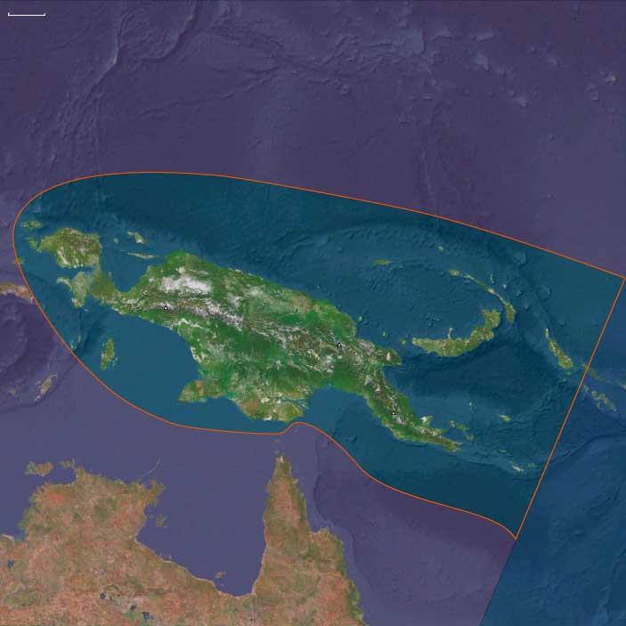
West Melanesia
Related Events
Filter results
Showing 10 events out of 57 total
The Far East, one of the twelve divisions of the Earth, encompasses northern Australia, the entire Indonesian archipelago (excluding Aceh and Sumatra), the Philippines, the island of New Guinea, mainland Southeast Asia, the Malay Peninsula, eastern and southern China (China proper), Taiwan, the Korean Peninsula, the southern portion of the Russian Far East, and most of the Japanese archipelago, except for Hokkaido.
The southeastern boundary runs through Micronesia and Melanesia, dividing these regions into eastern and western subregions.
The northwestern boundary follows a line that separates Mongolia from China and delineates the division between Xinjiang and Tibet from China proper. It extends from its northernmost point, just beyond the northern arc of the Amur River—which marks China’s border with Russia—to its westernmost point, at the tri-border junction of Burma, India, and the Bay of Bengal.
The northeastern boundary distinguishes the extreme southern portion of the Russian Far East from the rest of the district and separates most of Hokkaido from Honshu, Kyushu, and Shikoku.
The southwestern boundary encompasses nearly all of Southeast Asia, with the exception of Aceh, which juts into the Indian Ocean and forms the southern shore of the Strait of Malacca, historically the key maritime gateway to the East.
HistoryAtlas contains 4,553 entries for The Far East from the Paleolithic period to 1899.
Narrow results by searching for a word or phrase or select from one or more of a dozen filters.
Recent genetic studies suggest that Australia and New Guinea were populated by one single migration from Asia as opposed to several waves.
The land bridge connecting New Guinea and Australia became submerged approximately eight thousand years ago, thus isolating the populations of the two landmasses.
West Melanesia (49,293 – 28,578 BCE): Upper Pleistocene I — First Highland Foragers and Sahulian Bridges
Geographic & Environmental Context
West Melanesia includes New Guinea (main island), its adjacent islands (Bismarck Archipelago: New Britain, New Ireland, Manus; Admiralties), and the northern Solomons (Bougainville, Buka).
-
Anchors: the Central Highlands of New Guinea, the Sepik–Ramu basins, Papuan Gulf, Huon Peninsula, Bismarck chain (New Britain, New Ireland, Manus), and the northern Solomons (Bougainville).
-
Sahul connection: lowered sea level (~100 m below modern) joined New Guinea to Australia; Torres Strait was dry land.
-
The Bismarck Archipelago and Bougainville remained separated by open seas but closer than today.
-
Highland valleys were colder, often glaciated, with frost-prone basins.
Climate & Environmental Shifts
-
Last Glacial Maximum: cooler, drier; montane glaciers extended in the Central Highlands.
-
Coastal reefs retreated to shelf edges; intertidal flats expanded.
Subsistence & Settlement
-
Modern humans reached Sahul >45,000 BP; by this epoch, populations occupied New Guinea highlands and lowland coasts.
-
Foragers exploited tubers (wild yam, taro), nuts, small game, and marsupials.
-
Early rock shelter camps (e.g., Ivane Valley) show seasonal hunting.
Technology & Material Culture
-
Flaked stone tools of quartz, chert; ground stone use emerging for woodworking.
-
Early use of plant fibers for nets/bags; shelters adapted to highland frost.
Movement & Interaction Corridors
-
Movement along river valleys (Sepik–Ramu, Strickland, Fly); coast–inland exchange likely limited but present.
-
Occasional crossings into the Bismarcks hinted by obsidian movement.
Cultural & Symbolic Expressions
-
Rock art and ochre use widespread; symbolic burials appear in highland contexts.
Environmental Adaptation & Resilience
-
Flexible coast–inland foraging; fire regimes reshaped highland grasslands, aiding tuber growth and game visibility.
Transition
By 28,578 BCE, highland foragers and coastal groups had established enduring lifeways across New Guinea, part of the wider Sahulian world.
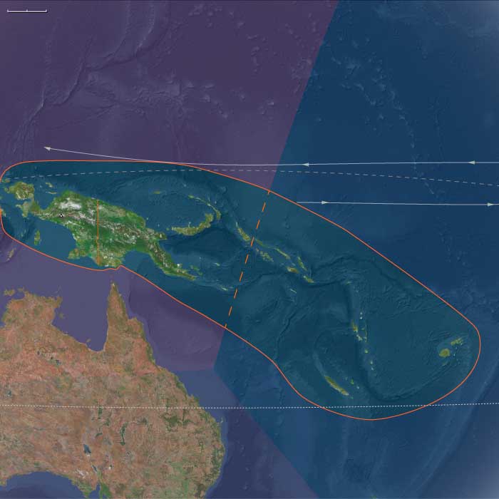
Melanesia (49,293 – 28,578 BCE): Upper Pleistocene I — Sahulian Highlands, Volcanic Arcs, and the Unpeopled Frontiers of Remote Oceania
Geographic & Environmental Context
During the height of the Late Pleistocene glaciation, Melanesia was divided into two very different worlds:
-
The western realm, including New Guinea, the Bismarck Archipelago, and the northern Solomons (Bougainville–Buka)—all part of the larger Sahul continent joined to Australia by the exposed Torres Shelf.
-
The eastern realm, the isolated island chains of Vanuatu, Fiji, New Caledonia, and the central–eastern Solomons (Guadalcanal–Malaita–Makira–Santa Cruz)—the volcanic and coral highlands of Remote Oceania, still uninhabited by humans.
Sea level lay roughly 100 meters below present, exposing broad continental shelves in the west and narrowing reef lagoons in the east. The Sahulian landmass extended north into Arafura–Carpentaria plains, while New Guinea’s central ranges rose into glaciated heights with periglacial basins and frost-prone valleys.
To the east, Vanuatu, Fiji, and New Caledonia stood as isolated volcanic arcs emerging steeply from deep basins—ecologically rich but geographically inaccessible to the foragers of the western coasts.
Climate & Environmental Shifts
-
Glacial World (49–30 ka):
Mean sea-surface temperatures across the Southwest Pacific were 2–3 °C cooler. Trade winds strengthened, intensifying upwelling on leeward coasts and bringing drier conditions to New Guinea’s highlands and valleys. The Central Cordillera supported small alpine glaciers, and montane forests gave way to open grassland and subalpine scrub. -
Toward the LGM (~30–28 ka):
Aridity peaked; coastal mangroves retreated; many lowland rivers cut deeply into exposed continental shelves. Cyclones and volcanic activity persisted episodically across the arc from New Britain to Fiji. -
Regional Contrast:
Western Melanesia retained significant rainfall and river flow, while Remote Oceania remained wetter overall but climatically cooler and more seasonally variable.
Western Melanesia: The Sahulian Heart
By this epoch, modern humans had long been established in New Guinea and the Bismarcks, forming one of the world’s most enduring highland–lowland adaptations.
-
Subsistence & Settlement
Foragers occupied glacial uplands such as the Ivane Valley (Central Highlands) and Kafiavana, where hearths, stone flakes, and grindstones attest to cold-climate resource management—small-game hunting, nut and tuber gathering, and controlled fire use to maintain open ground.
Along the Sepik–Ramu and Papuan Gulf, coastal and riverine communities exploited fish, mollusks, and estuarine mammals; reef flats now stranded high and dry would later become mangrove forests.
Fire regimes reshaped highland grasslands, encouraging regrowth and visibility for marsupial hunts, while wild tubers (precursors of yam and taro) were deliberately managed in cleared patches—the world’s earliest evidence of proto-horticultural systems. -
Technology & Material Culture
Flaked quartz and chert tools dominated; ground-stone axes began to appear for woodworking. Plant-fiber nets and string bags, now perishable, were probably in common use. Ochre and hematite were employed for body painting and symbolic burials.
Shelters—rock overhangs and built windbreaks—were adapted to frost and seasonal cold. -
Movement & Interaction Corridors
River corridors (Strickland, Fly, Sepik, Ramu) served as travel and exchange routes, connecting inland valleys with coastal lowlands. Although full ocean crossings were still rare, obsidian from New Britain occasionally reached New Guinea sites, hinting at incipient seafaring competence along sheltered coasts and straits. -
Cultural & Symbolic Life
Pigment use and ritualized burials reveal social continuity and symbolic depth. Fire—both a practical and ceremonial tool—was central to highland identity and landscape management.
Eastern Melanesia: The Unpeopled Frontier
Beyond the Sahul shelf lay Remote Oceania, a vast Pacific expanse scattered with volcanic arcs and coral plateaus—Vanuatu, Fiji, New Caledonia, and the eastern Solomons—all still empty of human life.
-
Ecosystems and Biota
Dense rainforests and cloud forests cloaked the high islands, nourished by volcanic soils. Reef and lagoon systems were narrower at glacial lowstand but maintained robust coral and fish populations. Seabird colonies, turtles, and flying foxes dominated terrestrial fauna; large reptiles and endemic birds filled ecological niches undisturbed by mammalian predators. -
Environmental Stability
Despite cooler sea-surface temperatures, reef–lagoon productivity remained high, buffering ecosystems through climatic oscillations. Volcanic ash periodically enriched soils, supporting evergreen canopies. These landscapes matured in isolation—an ecological Eden awaiting human discovery.
Environmental Adaptation & Resilience
Across the entire Melanesian domain, resilience stemmed from diversity and isolation:
-
In Western Melanesia, flexible foraging and fire-based ecosystem management allowed human populations to thrive through glacial extremes.
-
In Eastern Melanesia, biological systems maintained equilibrium without human influence—reefs recovered, forests recycled, and volcanoes renewed soils on cyclical timescales.
The contrast between peopled west and empty east defined Melanesia’s enduring duality: one a cradle of continuous habitation and innovation, the other a pristine wilderness preserved by distance.
Transition Toward the Holocene
By 28,578 BCE, Western Melanesian foragers had mastered every ecological zone from alpine valleys to coral flats, forming the cultural base of the later Papuan–Austronesian continuum.
To the east, volcanic and coral islands awaited the rise of sea levels and the eventual emergence of long-range voyagers.
The post-glacial world would soon redraw coastlines, creating new estuaries, lagoons, and archipelagos—the stage on which Lapita seafarers would one day appear.
But for now, Melanesia remained a divided world: the oldest continuously inhabited mountains on Earth facing a still-unpeopled Pacific horizon.
Human beings probably enter New Guinea around 50,000 BCE over a now-vanished land bridge that links the island with Asia.
In a series of migrations beginning more than foty thousand years ago, small groups of the semi-nomadic hunter-gatherers known as the Aborigines reach the Australian continent from Southeast Asia, probably taking advantage of land bridges available during times of low sea level.
West Melanesia (28,577 – 7,822 BCE): Upper Pleistocene II — Deglaciation, Highland Cultivation, and Bismarck Voyagers
Geographic & Environmental Context
West Melanesia includes New Guinea (main island), its adjacent islands (Bismarck Archipelago: New Britain, New Ireland, Manus; Admiralties), and the northern Solomons (Bougainville, Buka).
-
Anchors: the Central Highlands of New Guinea, the Sepik–Ramu basins, Papuan Gulf, Huon Peninsula, Bismarck chain (New Britain, New Ireland, Manus), and the northern Solomons (Bougainville).
-
Rising seas isolated New Guinea from Australia by c. 8,000 BCE, creating modern Torres Strait.
-
Bismarcks became fully separated but visible from New Guinea; Bougainville linked into a northern stepping-stone chain.
Climate & Environmental Shifts
-
Bølling–Allerød warming raised rainfall; glaciers retreated in highlands.
-
Younger Dryas briefly cooled/dried; Early Holocene warmth stabilized forests and streams.
Subsistence & Settlement
-
Early plant management in New Guinea highlands (Kuk Swamp precursors) c. 10,000–9,000 BCE: drainage ditches, taro/banana cultivation.
-
Coastal groups harvested shellfish, reef fish, and tree crops.
-
Bismarcks settled by c. 35–30,000 BP (obsidian evidence); island foragers practiced arboriculture and reef exploitation.
Technology & Material Culture
-
Ground stone axes for forest clearance; flaked tools persisted.
-
Obsidian exchange networks in Bismarcks intensified, linking Manus–New Britain–New Ireland.
-
Plant fiber cordage, nets, and bark containers common.
Movement & Interaction Corridors
-
Regular seafaring between New Guinea ⇄ Bismarcks; canoe precursors used for open-sea hops (visible islands aided navigation).
-
Highland–lowland exchange of forest products and shells.
Cultural & Symbolic Expressions
-
Rock art traditions expanded in highlands and islands; burials with ochre and ornaments continue.
Environmental Adaptation & Resilience
-
Early swamp drainage and plant tending hedged risk in frost-prone valleys; island foragers relied on arboriculture + reef systems.
Transition
By 7,822 BCE, New Guinea was home to some of the earliest horticulturalists globally, while the Bismarcks hosted robust seafaring foragers.
Melanesia (28,577 – 7,822 BCE): Late Pleistocene–Early Holocene — Forests, Gardens, and the First Sea Roads
Geographic & Environmental Context
During the Late Pleistocene and early Holocene, Melanesia—stretching from New Guinea and the Bismarck Archipelago to the Solomon chain, Vanuatu, Fiji, and New Caledonia—underwent a profound ecological and cultural transformation.
At the Last Glacial Maximum, lowered seas fused many islands into larger landmasses. As the ice melted, rising waters fragmented coastal plains, creating the modern archipelagos and isolating highland basins.
-
West Melanesia (New Guinea, Bismarcks, Bougainville): vast valleys, expanding rainforests, and active volcanoes framed by rich reefs and mangrove deltas.
-
East Melanesia (Solomons, Vanuatu, Fiji, New Caledonia): newly separated island chains with widening lagoons and thriving coral platforms.
By 7,800 BCE, the great Sahul–Melanesian bridge had vanished beneath the sea, leaving New Guinea and its eastern satellites distinct but still visible across narrow straits—a geography that would nurture the Pacific’s first sustained voyaging traditions.
Climate & Environmental Shifts
The end of the Pleistocene brought warmer, wetter climates and the full onset of the Holocene monsoon regime:
-
Bølling–Allerød (c. 14,700–12,900 BCE): sharp warming, heavier rainfall, and glacier retreat in the New Guinea highlands; forest expansion in valleys and along coasts.
-
Younger Dryas (12,900–11,700 BCE): brief cooling and drying; temporary contraction of montane forests.
-
Early Holocene (after 11,700 BCE): sustained warmth and humidity; stable rainfall re-established dense lowland and montane forests; coral reefs reached modern vigor.
These oscillations alternately exposed and drowned plains, prompting both adaptation in agriculture and the emergence of maritime corridors.
Subsistence & Settlement
Across Melanesia, lifeways diversified as people adjusted to deglaciation and expanding tropical biomes:
-
Highlands of New Guinea:
The Kuk Swamp system began forming precursors to drainage channels by c. 10,000–9,000 BCE. Here, people managed taro, banana, yam, and sugarcane, creating the world’s earliest known horticultural landscapes. Seasonal settlements along valley margins indicate growing sedentarism. -
Lowlands and coasts (New Guinea & Bismarcks):
Forager–fisher–gardeners exploited shellfish, reef fish, and forest nuts (Canarium, pandanus). Mangroves and estuaries offered stable protein year-round. Arboriculture (tree crop tending) and periodic burning expanded mosaic habitats. -
Island arcs (Solomons to Fiji & New Caledonia):
Communities established semi-sedentary coastal hamlets near lagoons and estuaries, supported by broad-spectrum diets—reef fish, shellfish, bird and reptile meat, and wild roots/tubers. Evidence of nut groves and forest-edge management points to early landscape control.
Population densities remained modest, but communities were increasingly anchored to specific territories defined by reef passes, valleys, and resource-rich bays.
Technology & Material Culture
Technological innovation mirrored this dual terrestrial–marine focus:
-
Ground-stone axes and adzes emerged for forest clearance and woodworking; flaked tools persisted for finer work.
-
Obsidian from the Bismarck volcanic chain (Talasea, Lou) circulated widely—marking one of the earliest systematic exchange networks in human history.
-
Cordage, baskets, and bark containers supported mobility and food storage; shell ornaments and ochre burials continued symbolic traditions.
-
Early canoe forms—likely hollowed logs stabilized with outriggers—enabled short open-sea crossings between visible islands, laying foundations for Oceanic seafaring.
Movement & Interaction Corridors
Melanesia’s fragmented geography became an engine of connection rather than isolation:
-
West Melanesia: regular crossings linked New Guinea ⇄ Bismarcks ⇄ Bougainville, distributing obsidian, shell, and forest products.
-
East Melanesia: expanding inter-island voyaging joined Solomons ⇄ Vanuatu ⇄ Fiji ⇄ New Caledonia, forming a maritime network that prefigured later Remote Oceania circuits.
-
Highland–lowland exchange systems traded salt, stone, and forest goods for marine shells and pigments.
This dynamic flow of goods and knowledge marked the first sustained inter-island navigation in the Pacific realm.
Cultural & Symbolic Expressions
Cultural expression blossomed with environmental security:
-
Rock art traditions flourished in New Guinea valleys and island caves—depicting fauna, geometric patterns, and spirit figures linked to fertility and ancestry.
-
Ochre use in burials, shell jewelry, and carved bone objects reflected ritual continuity.
-
The integration of forest and sea cosmologies—mountain spirits, ancestor shells, water serpents—rooted identity in ecological abundance and exchange.
Environmental Adaptation & Resilience
Resilience derived from diversified subsistence and land–sea integration:
-
Horticulture and arboriculture stabilized food supplies amid shifting rainfall and rising seas.
-
Reef harvesting and lagoon fisheries ensured high protein availability even in climatic downturns.
-
Voyaging alliances between neighboring islands offset local resource failures and cemented social ties.
-
Forest regrowth management through selective clearing and fire maintained balance between cultivation and wild biodiversity.
Long-Term Significance
By 7,822 BCE, Melanesia stood as one of humanity’s most sophisticated forager–horticultural regions:
-
In West Melanesia, the New Guinea highlands had pioneered swamp cultivation and forest management—among the world’s earliest farming systems.
-
In East Melanesia, inter-island voyaging and lagoon-based economies anticipated the maritime adaptations of later Lapita and Polynesian cultures.
Together, they defined a dual legacy—gardens of earth and gardens of sea—rooted in innovation, mobility, and ecological reciprocity that would shape Pacific civilization for the next ten millennia.
Traces of starch from an apparently domesticated variety of the taro plant on flint tools from the Solomon Islands suggests that conscious planting is being done in the Pacific by 28,000 BCE.
Papuans, the earliest people in the Western Melanesia, had occupied the Sahul continent, which later partially submerged to become the island of New Guinea, at least forty thousand years ago.
By thirty thousand years ago, speakers of Papuan languages had occupied the Bismarck Archipelago east of New Guinea.
Human habitation begins in the western Pacific about 28,000 BCE, around the time that humans inhabit Palawan in the Philippines.