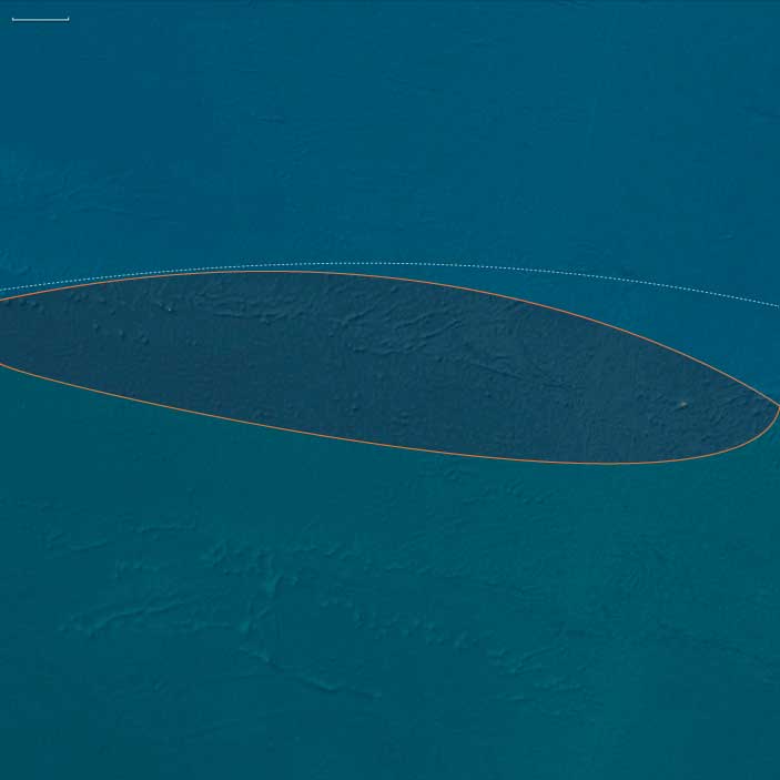
East Polynesia
Related Events
Filter results
Showing 10 events out of 51 total
Polynesia (49,293 – 28,578 BCE): Upper Paleolithic I — Volcanic Arcs, Reef Foundations, and the Architecture of Isolation
Geographic & Environmental Context
During the later Pleistocene, the Polynesian sector of the Pacific was a scattered domain of volcanic peaks, emerging atolls, and widening reef flats—a geography still entirely devoid of humans but already constructing the natural architecture that would one day sustain them.
The region spanned three great arcs of islands:
-
The Hawaiian–Emperor chain in the north, including Oʻahu, Maui, Molokaʻi, Kauaʻi, Niʻihau, and Midway, where high volcanic forms dominated the subtropics.
-
The central–western archipelagos—Tonga, Samoa, the Cook and Society Islands, the Marquesas, Tuvalu, and Tokelau—a mixture of high volcanic islands, raised limestone platforms, and embryonic atolls.
-
The eastern fringe—future Pitcairn and Rapa Nui—where lone volcanic edifices rose from deep ocean basins, linked only by the great South Pacific gyres and currents.
Sea level stood ~100 m lower than today, exposing vast coastal benches and broad shelves around high islands. Many modern lagoons lay dry, their reef rims fossilized in the air; others built episodically with interglacial warm phases. Across the region, reef, volcano, and ocean interacted in long cycles of uplift and subsidence—the slow choreography that would, over tens of millennia, produce the Polynesian Triangle’s intricate geography.
Climate & Environmental Shifts
The epoch was framed by full glacial conditions—cooler sea-surface temperatures, stronger trade winds, and a sharply defined dry season.
-
Atmosphere and Ocean: Strengthened trades drove upwelling along many leeward coasts, favoring cool, nutrient-rich nearshore waters. Seasonal dust episodes and winter surf reworked coastal benches, while the intertropical convergence zone (ITCZ) oscillated northward and southward with orbital rhythms.
-
Late-Glacial Variability: Even within the long glacial, brief mild interstadials brought short-lived reef growth spurts and pulses of vegetation recovery. Cooler phases depressed the coral-algal community but expanded coastal steppe and dry scrub.
-
Volcanic Activity: Continuous effusive volcanism in the Hawaiian Big Island and intermittent eruptions in the Societies, Marquesas, and Cooks rejuvenated landscapes, built fresh lava plains, and created ephemeral crater lakes and ash-fed soils.
Overall, Polynesia’s climate oscillated between cool, windy glacial stability and short warming pulses that allowed the reef crest and forest line to advance and retreat in rhythm with the global climate.
Biota & Baseline Ecology (No Human Presence)
Every island was its own closed laboratory of evolution.
-
Marine Life:
Coral communities fluctuated with sea level and temperature, but even under glacial suppression, shallow fringing reefs persisted. Fish, mollusk, turtle, and seabird populations were immense, their only predators sharks and seals. On outer banks like Midway, Tokelau, and Tuvalu, monk seals and turtles bred in numbers far exceeding modern densities. -
Terrestrial Life:
The higher islands—Hawaiʻi, Tahiti, Samoa, the Marquesas—carried dense montane forests in windward belts and dry woodland or grass steppe on leeward slopes. Cloud forests crowned the summits, capturing mist even under glacial dryness. Each island hosted unique, isolated assemblages of birds, insects, and plants, evolving in splendid isolation. -
Avian Realms:
Seabird supercolonies occupied cliffs and stacks, fertilizing soils with guano and enriching nearshore ecosystems. On atolls and cays, the air was dense with terns, boobies, and petrels—an avian kingdom uninterrupted by human disturbance.
Environmental Processes & Dynamics
-
Reef and Lagoon Evolution: Lower sea levels exposed broad reef flats, which weathered into limestone benches; with each brief warming, corals recolonized and built new terraces—a staircase of future lagoons.
-
Volcano–Erosion Cycles: Heavy rainfall on high islands carved deep amphitheaters (e.g., Waiʻanae, Koʻolau, and Tahiti’s ancient calderas), while aridity on leeward slopes preserved lava plains and dunes.
-
Marine Productivity: Upwelling zones around island chains created feeding grounds for pelagic fish and whales; kelp-like macroalgae likely formed dense nearshore beds in cooler zones, anchoring early “reef forest” ecologies.
-
Atmospheric Circulation: Persistent trades sculpted the cloud belts that would later define Polynesian ecological duality—lush windward valleys and dry leeward coasts.
Long-Term Significance
By 28,578 BCE, Polynesia’s physical and biological foundations were firmly in place:
-
Volcanic arcs had matured into high-island chains with deep, fertile amphitheaters and developing river networks.
-
Coral reef systems, though suppressed by glacial cooling, had established their long-term frameworks, ready to surge during Holocene sea-level rise.
-
Forest and reef ecologies had stabilized into enduring zonations—ridge forests, dry scrub, coastal strand, reef-flat, and pelagic edge—that would persist through the Holocene.
The epoch thus created Polynesia’s essential blueprint: a world of towering volcanic islands, expanding reef terraces, seabird-sustained fertility, and unbroken ecological isolation.
In the ages to come, these formations would become the living stage for one of Earth’s greatest human voyaging traditions—a future civilization built upon the deep-time architecture of glacial Polynesia.
East Polynesia (28557 – 7822 BCE): The Far-Flung Isles of the Empty Ocean
Geographic and Environmental Context
East Polynesia—including the Pitcairn Islands, Easter Island (Rapa Nui), and nearby seamounts—formed the far eastern apex of the Polynesian Triangle.
-
These islands are oceanic in origin, volcanic or uplifted, and extremely isolated from any continental landmass.
-
During the Late Pleistocene, lower sea levels slightly increased land area on some islands, exposing coastal terraces and enlarging reef flats.
-
The surrounding Pacific was influenced by the South Equatorial Current, which brought warm waters year-round.
Climate and Environmental Shifts
-
Last Glacial Maximum (c. 26,500 – 19,000 BCE): Slightly cooler sea-surface temperatures and lowered sea levels affected reef growth rates; exposed coastal flats expanded nesting areas for seabirds and turtles. Rainfall remained moderate due to the islands’ equatorial–subtropical position.
-
Bølling–Allerød (c. 14,700 – 12,900 BCE): Warmer, wetter conditions boosted reef productivity; coastal vegetation flourished, and seabird populations increased.
-
Younger Dryas (c. 12,900 – 11,700 BCE): Modest cooling and seasonal rainfall variation slightly reduced vegetative growth rates, but ecosystems remained generally stable.
-
Early Holocene (after c. 11,700 BCE): Rising seas flooded exposed coastal terraces and reestablished modern shorelines; coral reefs expanded rapidly under warm, stable conditions.
Flora, Fauna, and Ecology
-
Terrestrial flora consisted of coastal strand plants, scrub, and limited inland forest, maintained by nutrient input from seabird guano.
-
Birdlife was abundant, with dense colonies of petrels, terns, frigatebirds, and shearwaters.
-
Marine life included coral reef ecosystems rich in fish, mollusks, crustaceans, and marine turtles.
-
With no human presence, all terrestrial and marine species existed in predator-free ecosystems, leading to the survival of ground-nesting seabirds in vast numbers.
Human Presence
-
No evidence of human visitation exists for this epoch; the islands were beyond the reach of even the most advanced late Pleistocene voyagers.
-
Their extreme remoteness meant they remained outside the known seascape of contemporary coastal peoples.
Environmental Dynamics
-
Reef flats and lagoons served as nurseries for fish and invertebrates.
-
Volcanic activity, though minimal in this period, influenced soil fertility on younger islands.
-
Seasonal storm systems occasionally reshaped beaches and coastal vegetation belts.
Symbolic and Conceptual Role
For human societies elsewhere in the Pacific, these lands lay entirely beyond the known horizon, neither visited nor imagined.
Transition Toward the Holocene
By 7822 BCE, East Polynesia’s islands had stable climates, fully developed reefs, and undisturbed terrestrial ecosystems. They would remain untouched by humans until the remarkable long-distance voyages of the late Holocene Polynesian navigators.
Polynesia (28,577 – 7,822 BCE): Late Pleistocene–Early Holocene Transition — Emerging Arcs, Drowned Plateaus, and Reef Foundations
Geographic & Environmental Context
During the Late Pleistocene and early Holocene, Polynesia—stretching from the Hawaiian archipelago across Samoa, Tonga, the Cook and Society Islands, to the far eastern outliers of Pitcairn and Rapa Nui—remained entirely unpeopled, a scattered constellation of volcanic and reefed islands rising above the world’s largest ocean.
At the Last Glacial Maximum (c. 26,500–19,000 BCE), global sea levels stood more than 100 m lower than today, exposing wide coastal shelves and tightening inter-island channels. As ice sheets melted, deglaciation flooded ancient shorelines, transforming basins into lagoons and seamounts into isolated atolls.
-
North Polynesia (Oʻahu, Maui Nui, Kauaʻi–Niʻihau, Midway Atoll): the Maui Nui shelf—once a single island—became a cluster of channels; Midway’s rim expanded as new lagoons formed.
-
West Polynesia (Hawaiʻi Island, Tonga, Samoa, Tuvalu–Tokelau, Cook, Society, and Marquesas): reefs and barrier lagoons built up around volcanic peaks, while low atolls appeared as sea level rose.
-
East Polynesia (Pitcairn, Rapa Nui, and nearby seamounts): the farthest outposts of the Pacific, geologically young and ecologically self-contained, fringed by narrow reef flats and rich upwelling zones.
Across this immense realm, oceanic currents—the South and North Equatorial and the Kuroshio–Equatorial Counter-flow system—created predictable gyres, establishing the hydrological backbone that would later sustain Polynesian voyaging.
Climate & Environmental Shifts
The epoch was one of oscillation and renewal:
-
Last Glacial Maximum (26,500–19,000 BCE): cooler seas and exposed shelves expanded coastal plains; coral growth slowed under lowered sea level.
-
Bølling–Allerød interstadial (c. 14,700–12,900 BCE): warmth and rainfall increased; reefs surged upward in “catch-up” growth; lagoons and barrier formations matured.
-
Younger Dryas (12,900–11,700 BCE): brief cooling flattened reef accretion and restricted mangroves; trade-wind aridity spread in leeward belts.
-
Early Holocene (after 11,700 BCE): steady warming and sea-level stabilization allowed coral terraces, mangroves, and strand forests to reach near-modern equilibrium.
By 7822 BCE, the Pacific climate engine had achieved its Holocene rhythm—warm, humid, and oceanically stable.
Biota & Baseline Ecology (No Human Presence)
Polynesia’s ecosystems reached pristine balance under rising seas:
-
Reefs and lagoons flourished with coral, mollusks, crustaceans, and reef fish (parrotfish, surgeonfish, mullet); spur-and-groove structures and back-reef ponds became marine nurseries.
-
Coastal vegetation—pandanus, beach heliotrope, ironwood, and grasses—rooted in guano-enriched sands; strand forests stabilized dunes.
-
Cloud-forests cloaked high islands such as Tahiti and Savaiʻi, while dry leeward slopes supported shrub and palm mosaics.
-
Seabirds nested in immense colonies; turtles hauled out on beaches; marine mammals frequented newly formed bays.
All existed in predator-free isolation, each island a laboratory of speciation and resilience.
Geomorphic & Oceanic Processes
As the sea rose, island landscapes underwent continuous re-sculpting:
-
Reef accretion kept pace with transgression, forming the first true atoll rings.
-
Maui Nui’s plateau fragmented into separate islands; Hawaiʻi Island’s volcanic plains met new coasts.
-
Eastern high islands (Rapa Nui, Pitcairn) gained fertile volcanic soils through slow weathering; storm surges and wave reworking created terraces and embayments.
-
Sediment deltas at stream mouths formed early estuarine wetlands—future sites for Polynesian fishponds and irrigated terraces.
Symbolic & Conceptual Role
For millennia these lands remained beyond the human horizon—unimagined yet forming the ecological architecture that would one day welcome voyagers. Their mountains, lagoons, and reefs became the stage on which later Polynesian societies would enact origin stories of sea and sky.
Environmental Adaptation & Resilience
Natural resilience was inherent:
-
Coral reefs tracked rising seas through vertical growth, preventing ecological collapse.
-
Guano-fertilized soils accelerated vegetative colonization after storm disturbance.
-
Cloud-forest hydrology maintained water flow even in drier pulses.
These feedbacks produced long-term equilibrium between land, sea, and atmosphere—the defining ecological rhythm of Polynesia.
Long-Term Significance
By 7,822 BCE, Polynesia had become a fully modern oceanic system: drowned plateaus transformed into lagoons and atolls; coral terraces and forest belts stabilized; seabird and reef ecologies reached peak diversity.
Though still empty of humankind, the region now possessed every element—predictable currents, fertile reefs, sheltered bays, and stable climates—that would, tens of millennia later, make it the natural cradle of the world’s greatest voyaging tradition.
The Ends of the Earth, one twelfth of the Earth’s surface, is bordered by the South Atlantic and South Pacific Oceans and includes Subcontinental South America, the Chonos Archipelago, Chiloé Island, Tierra del Fuego, the Falkland Islands, the remote Juan Fernández Islands (notably home to the marooned sailor Alexander Selkirk from 1704 to 1709, an experience thought to have inspired Daniel Defoe’s Robinson Crusoe), the even more remote Easter Island, and West Antarctica—the portion of Antarctica that lies within the Western Hemisphere and includes the Antarctic Peninsula.
Easter Island, culturally Polynesian yet governed by Chile, is among the most isolated inhabited islands in the world, positioned in the eastern South Pacific Ocean at the northwestern edge of The Ends of the Earth, along with the equally remote Pitcairn Islands.
The southeastern and southwestern boundaries divide West Antarctica from the much larger East Antarctica.
The northeastern boundary follows the approximate courses of the Colorado and Barrancas Rivers, which flow from the Andes to the Atlantic Ocean and are traditionally recognized as the northern limit of Argentine Patagonia.
For Chilean Patagonia, most geographers and historians identify its northern boundary at the Huincul Fault in the Araucanía Region.
HistoryAtlas contains 153 entries for The Ends of the Earths from the Upper Paleolithic period to 1899.
Narrow results by searching for a word or phrase or select from one or more of a dozen filters.
Polynesia (7,821 – 6,094 BCE): Early Holocene — Thermal Optimum Seas and Islands in Equilibrium
Geographic & Environmental Context
During the Early Holocene, Polynesia—extending from the Hawaiian archipelago across Samoa, Tonga, and the Society Islands to the still-forming volcanic ridges of what would become Rapa Nui and Pitcairn—remained entirely unpeopled yet ecologically self-organized.
The global thermal optimum (c. 8,000–6,000 BCE) raised sea-surface temperatures and stabilized wind and current systems across the tropical Pacific.
High islands such as Oʻahu, Tahiti, and Savaiʻi bore deep belts of cloud forest, while their leeward coasts supported expanding reef-lagoon mosaics.
Emergent atolls and carbonate platforms—Tuvalu, Tokelau, and Midway—stood as low, gleaming rims on a still-rising ocean, already threaded by trade-wind-driven nutrient circuits.
Climate & Environmental Shifts
The Early Holocene Optimum produced the warmest and most stable Pacific climate of the Quaternary.
-
Sea levels continued their post-glacial rise, reaching only a few meters below present; newly drowned coastal shelves became lagoons and barrier-reef arcs.
-
Trade winds and monsoonal convergence zones settled into predictable rhythms, ensuring orographic rain on windward mountains and long dry seasons on leeward coasts.
-
ENSO activity was weak or absent; the Pacific climate engine ran with near-mechanical reliability.
These steady conditions allowed ecosystems to mature without major disturbance for more than a millennium.
Biota & Baseline Ecology (Before Human Arrival)
Polynesia at this stage was a realm of maximal endemic richness and ridge-to-reef productivity:
-
Forests: dense montane and mesic stands of hardwoods, Pandanus, and tree ferns cloaked volcanic slopes; lowlands carried palm and coastal scrub communities.
-
Freshwater systems: perennial streams sculpted alluvial fans and fed wetland complexes behind beach ridges—later to become ideal taro-pond basins.
-
Reefs and lagoons: coral growth kept pace with sea-level rise; fish biomass, clam beds, and crustacean diversity peaked; guano from seabird colonies fertilized nearshore flats.
-
Seabird rookeries blanketed outer islets, coupling marine nitrogen to terrestrial fertility.
-
Atolls and low islands: thin soils supported grasses, heliotropes, and mangrove thickets along brackish lagoons—incipient blueprints for future habitation.
Geomorphic and Oceanic Processes
A gentle post-glacial transgression reshaped Polynesia’s coastlines: drowned river mouths became estuaries and bay-head deltas; reef crests migrated upward; mangroves and peat lenses accumulated behind storm ridges.
Volcanic islands such as Hawaiʻi Island, Tahiti, and Rarotonga continued to build and erode simultaneously, feeding rich sediment to deltas.
Across the central Pacific, the South Equatorial Current and its counterflows organized enduring biological highways, prefiguring the navigation corridors of future voyagers.
Regional Profiles
-
North Polynesia (Hawaiian chain except Hawaiʻi Island): Warm seas and reliable trades sustained lush cloud-forest belts, valley wetlands, and stable lagoon fisheries.
-
West Polynesia (Hawaiʻi Island, Samoa, Tonga, Society Islands, Cook Islands, Tuvalu–Tokelau, Marquesas): Reef–valley coupling reached perfection—mountain rainfall feeding coastal productivity.
-
East Polynesia (Pitcairn group, Rapa Nui, and outlying ridges): Newly emergent volcanic highlands and surrounding seamounts hosted pioneer flora—ferns, grasses, and mosses—and rapidly accreting coral rims.
Together these arcs formed a climatic and ecological continuum, unbroken by storm or current.
Environmental Adaptation & Resilience
Without humans, natural feedback loops maintained equilibrium:
-
Cloud-forest evapotranspiration recycled rainfall; mangroves trapped sediment and built new ground.
-
Coral reefs tracked sea-level rise through vertical accretion, preserving lagoon depth and productivity.
-
Seabirds, turtles, and migratory fish redistributed nutrients across thousands of kilometers.
Disturbance—occasional cyclone or lava flow—was localized and quickly absorbed, strengthening rather than destabilizing ecosystem complexity.
Long-Term Significance
By 6,094 BCE, Polynesia had reached its pre-human ecological zenith.
Across every island chain, the ridge-to-reef continuum—from cloud forest to stream to reef flat—operated in perfect balance.
These conditions provided the environmental templates for later Polynesian agriculture, aquaculture, and navigation.
The Early Holocene thus marked an age of formation rather than transformation—a prolonged prelude in which the ocean composed its stage for the human voyaging worlds to come.
Polynesia (4,365 – 2,638 BCE): Late Neolithic — Predictable Seas and Awaiting Worlds
Geographic & Environmental Context
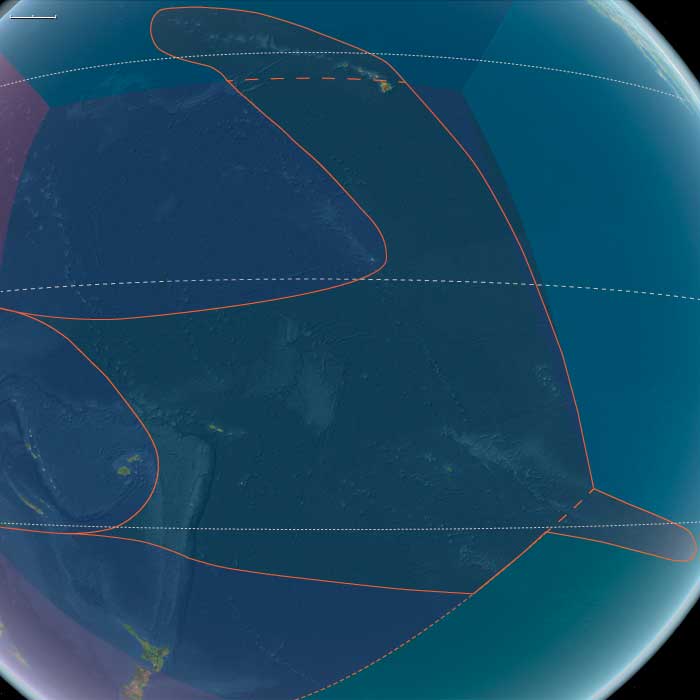
Polynesia spans a vast triangle across the central and eastern Pacific, encompassing three distinct environmental realms:
-
North Polynesia, including the Hawaiian Islands chain (except Hawaiʻi Island) and Midway Atoll.
-
West Polynesia, extending from Hawaiʻi Island through Tonga, Samoa, Tuvalu, Tokelau, the Cook Islands, the Society Islands, and the Marquesas.
-
East Polynesia, comprising the Pitcairn Islands and Easter Island (Rapa Nui).
Across this expanse, volcanic high islands alternated with atolls and raised coral platforms, forming ecological mosaics of ridges, streams, lagoons, and reefs.
In the west and north, basaltic uplands captured trade-wind rains, while eastern islands—more isolated and younger—remained sparsely vegetated and edged by nutrient-rich marine shelves.
Each island system formed a self-contained world linked by atmospheric rhythms and the open ocean’s consistent pulse.
Climate & Environmental Shifts
Throughout this epoch, the Pacific trade-wind system stabilized, its regularity shaping future patterns of navigation.
-
In North Polynesia, gentle but persistent rainfall sustained perennial streams; winter surf reworked reef passes and sand spits.
-
In West Polynesia, inter-island visibility and seasonal swell windows became predictably cyclical, forging the basis of later star-path navigation.
-
In East Polynesia, the South Pacific Gyre moderated temperatures and rainfall, while weak ENSO variation fostered long-term stability in coastal processes.
The overall climate pattern was one of gentle equilibrium—ideal for the development of ridge-to-reef ecosystems later adapted to human use.
Biota & Baseline Ecology (before human arrival)
All three subregions remained uninhabited during this epoch.
-
North Polynesia’s humid valleys nourished dense ferns and native forests whose runoff enriched productive reefs and lagoons.
-
West Polynesia maintained high-diversity reef crests, extensive seabird rookeries, and intact coastal woodlands.
-
East Polynesia’s young volcanic soils bore pioneer grasses and shrubs, while seabirds and marine mammals formed nutrient linkages across land and sea.
In each, avian colonies and reef systems underpinned ecological productivity, generating food webs that would later sustain human settlement. The interdependence of ridge, stream, and reef defined a continuum of life stretching from mountain mist to coral flat.
Societies and Political Developments
No permanent human communities yet occupied Polynesia. The landscapes existed as ecological laboratories, refining the environmental patterns that would later shape human adaptation.
Isolated from continental biomes, these islands evolved as closed systems, each displaying an early balance between soil formation, plant succession, and marine fertility—conditions that would invite settlement millennia later.
Economy and Trade
Absent of humans, there was no economy or trade in the human sense; yet natural exchanges thrived.
Guano from seabirds fertilized uplands, basaltic runoff fed nearshore plankton blooms, and seasonal upwelling transported marine nutrients across thousands of kilometers.
These were the proto-economies of nature—flows of energy and matter that prefigured the human cultivation and exchange systems of the later Holocene Pacific.
Belief and Symbolism (prospective foundations)
Though uninhabited, Polynesia’s landscapes already held symbolic potential.
Towering volcanic peaks, thundering surf, and the night sky’s unbroken clarity formed the visual grammar that would later underlie Polynesian cosmology—the concept of a living ocean, sky pathways, and island genealogies rooted in stone and star alike.
The geography itself preserved the template for sacred space, awaiting the narratives that human voyagers would eventually inscribe upon it.
Adaptation and Resilience
These ecosystems demonstrated extraordinary resilience.
Windward forests regenerated after storms; coral reefs recovered rapidly from sediment influx; atoll lagoons adjusted dynamically to sea-level fluctuations.
The feedback systems that stabilized these islands over millennia created a naturally buffered environment—one later mirrored by Polynesian ridge-to-reef stewardship practices such as loʻi kalo irrigation and loko iʻa fishpond construction.
Long-Term Significance
By 2638 BCE, Polynesia’s seas, skies, and island chains had matured into one of Earth’s most predictable and interconnected oceanic systems.
Its climatic stability, ecological richness, and clear navigational horizons provided the perfect preconditions for human exploration.
When settlement finally came, Polynesian societies would inherit not a wilderness, but a finely tuned set of living laboratories—each island a self-sustaining microcosm of the Pacific world, pre-adapted for the synthesis of ecology, navigation, and culture that would define Oceania’s later civilizations.
East Polynesia (4,365 – 2,638 BCE): Late Neolithic (regional) — Emergent Island Systems and Marine Frontiers
Geographic & Environmental Context
East Polynesia includes the Pitcairn Islands and Easter Island (Rapa Nui). Both mark the far eastern reach of the Polynesian triangle, set apart by vast expanses of open sea.
Anchors: the volcanic massifs and crater lakes of Easter Island (Terevaka, Poike, Rano Kau) and the basalt core and coral terraces of Pitcairn.
Climate & Environmental Shifts
Subtropical to temperate conditions prevailed, moderated by the South Pacific Gyre.
Trade winds remained steady, while occasional southerly air flows introduced cooler and cloudier intervals. ENSO variability was weak, and rainfall patterns stable, allowing gentle soil formation and coastal sediment accretion.
Biota & Baseline Ecology (No Human Presence)
Thin volcanic soils supported sparse ferns, shrubs, and pioneer grasses.
Reef ecosystems flourished around lava benches and submerged platforms, harboring diverse fish and coral assemblages.
Seabird colonies blanketed the cliffs, their guano enriching otherwise nutrient-poor lands, while seasonal seal and turtle populations enhanced coastal productivity.
Long-Term Significance
At the outermost edge of the Pacific, these islands formed a natural frontier of scarcity and resilience.
Their isolation and self-contained ecosystems would later foster distinctive adaptive strategies in agriculture and marine harvesting — the foundations of future Polynesian ingenuity and endurance at the world’s eastern limit.
Polynesia (2637 – 910 BCE): Lapita Horizons, Voyaging Science, and the Unreached North
Regional Overview
Across the open Pacific, Polynesia lay poised for its first true colonization.
While the great civilizations of Eurasia turned to bronze, iron, and empire, this oceanic world entered an age of exploration defined not by metals but by canoes, stars, and memory.
Between the mid-third and early first millennium BCE, Austronesian voyagers—descendants of Lapita pioneers—pushed eastward from the Bismarck and Fijian arcs, testing routes that would one day span a third of the globe.
The southern frontier, in Tonga and Samoa, saw permanent settlement by about 900 BCE.
Farther east and north, the Societies, Marquesas, Hawaiʻi, and Rapa Nui remained pristine: mapped in mind, not yet in habitation.
Geography and Environmental Context
The Polynesian triangle—bounded by future Hawaiʻi, New Zealand, and Rapa Nui—was still largely empty of people.
To the south and west, Lapita societies thrived along the Fiji–Tonga–Samoa axis, a zone of fertile volcanic soils, reef-sheltered coasts, and abundant breadfruit and taro.
Northward stretched the high, forested islands of the Hawaiian chain and the remote atoll of Midway; eastward, the volcanic peaks of the Societies and Marquesas, the coral ridges of the Cooks, and the lonely cones of Rapa Nui and Pitcairn awaited discovery.
Across these immense distances, the Pacific’s trade winds, countercurrents, and celestial regularities provided the framework for navigation.
Climate and Environmental Shifts
Holocene stability reigned.
Regular trade-wind seasons, interspersed with localized droughts and Kona-type storms, defined the pattern familiar through later millennia.
Sea levels had stabilized close to modern elevations, lagoons and atolls matured ecologically, and coral reef systems reached their pre-human equilibrium—a pristine baseline soon to host the transported landscapes of Polynesian horticulture.
Societies, Settlement, and Expansion
By the early first millennium BCE, Lapita communities from Near Oceania had developed into full maritime chiefdoms.
They founded Tonga and Samoa, bringing with them domesticated animals, tubers, tree crops, and an integrated horticultural–fishing economy.
Their settlements, organized around coastal hamlets and beach-ridge cemeteries, formed the first enduring societies in what would become Polynesia proper.
These colonists combined intricate kinship systems with lineage-based authority expressed through exchange and feasting.
Beyond them, the high islands and atolls of central and northern Polynesia remained unvisited—the last great frontier of the human voyage.
Economy and Technology
Lapita subsistence depended on mixed horticulture, arboriculture, and reef harvesting.
Stone and shell adzes, barkcloth looms, and obsidian tools underpinned daily life.
Pottery—characterized by its distinctive dentate-stamped designs—served as both utilitarian ware and a marker of cultural identity.
The real technological revolution, however, lay in seamanship: the refinement of the double-hulled canoe, the balanced crab-claw sail, and the astronomical navigation system that made deliberate ocean crossings routine.
These innovations transformed the Pacific from a barrier into a continent of water.
Movement and Interaction Corridors
A dense voyaging corridor linked Fiji, Tonga, and Samoa, forming the nucleus of the later Polynesian exchange sphere.
Exploratory probes reached eastward toward the Cook and Society Islands and northward into uncharted waters, where Hawaiʻi’s volcanic silhouettes awaited future landfall.
Each expedition tested wind patterns, star paths, and ocean swells, gradually extending the mental map of the ocean.
The Lapita maritime network thus became the laboratory from which Polynesian wayfinding emerged.
Belief and Symbolism
Lapita iconography—incised faces, spirals, and concentric motifs—encoded ancestral and cosmological themes, linking the sea, lineage, and creation.
Sacred beach terraces, aligned to the horizon, may represent early forms of marae or ahu, foreshadowing the ritual architecture of later Polynesia.
Voyaging itself was a sacred act: canoes were consecrated, navigators initiated, and landfalls interpreted as fulfillments of ancestral design.
Environmental Adaptation and Resilience
Colonists transported a complete biocultural package—taro, yam, breadfruit, coconut, pig, dog, chicken, and the social institutions to manage them.
They sited villages in leeward zones sheltered from cyclones, practiced intercropping for soil stability, and established portable ecosystems that could regenerate on any new island.
In yet-unsettled regions, natural ecosystems continued undisturbed, providing the environmental blank slate that later settlers would transform into productive landscapes.
Regional Synthesis and Long-Term Significance
By 910 BCE, Tonga and Samoa stood as the Lapita world’s eastern bastions, while the vast remainder of Polynesia remained silent and untouched.
Yet every element of the later Polynesian achievement was already in place—the technology, cosmology, and navigational genius that would soon knit the central and northern Pacific into a single cultural sphere.
This epoch thus represents Polynesia in potential: a constellation of islands awaiting connection, its human story poised at the threshold of discovery.
East Polynesia (2637 – 910 BCE): The Remote Eastern Apex
Geographic and Environmental Context
East Polynesia—including Easter Island (Rapa Nui) and the Pitcairn Islands—formed the far southeastern point of the Polynesian Triangle. Both were volcanic in origin, with Rapa Nui characterized by rolling volcanic hills, freshwater crater lakes, and arable soils, while the Pitcairn Islands presented rugged coastlines, forested slopes, and limited lowland plains. The surrounding South Pacific waters were warm but relatively nutrient-poor, with marine life concentrated in reef and nearshore environments.
Subsistence and Settlement
There is no evidence of permanent human settlement in East Polynesia during this epoch. However, the islands’ resources made them potentially valuable to exploratory voyagers:
-
Rapa Nui had fertile soils and enclosed freshwater sources in volcanic craters.
-
Pitcairn had forest resources, nesting seabirds, and freshwater springs.
Any landfall during this period would likely have been short-term, focused on fishing, gathering seabirds and eggs, and collecting fresh water before departing.
Technological and Navigational Context
Reaching East Polynesia from West or Central Polynesia required some of the longest open-ocean voyages in prehistory, often over 2,000 km with no intermediate landfalls. Voyaging demanded double-hulled canoes capable of carrying ample provisions, navigators skilled in star compasses, ocean swell interpretation, and avian flight tracking, and coordinated crew expertise for prolonged sea passages.
Environmental Characteristics and Resource Use
-
Rapa Nui: Volcanic soils capable of supporting root crops like taro and yam; freshwater in crater lakes; rocky coasts for fishing and shellfish gathering.
-
Pitcairn Islands: Forest cover for timber; limited arable land; rich seabird rookeries and inshore fisheries.
Both locations lacked land mammals but offered abundant marine and avian protein.
Cultural and Symbolic Role
Even if not visited, these islands may have existed in the conceptual horizon of Polynesian navigators as the ultimate eastern limit—places of challenge, achievement, and perhaps spiritual significance in oral tradition. In later centuries, such distant lands often featured in migration stories and cosmological maps.
Environmental Adaptation and Resilience
Exploratory crews would have needed to maximize fresh water collection, preserve fish and other foods, and time voyages to seasonal wind shifts for safe return. The capacity to survive and navigate in such remote seas reflects the apex of Polynesian wayfinding skill.
Transition to the Early First Millennium BCE
By 910 BCE, East Polynesia remained beyond the frontier of regular Polynesian voyaging, awaiting the later period of long-range expansion. Its eventual settlement would mark one of the greatest achievements in human navigation, completing the settlement of the world’s largest oceanic expanse.
People from Melanesia and Micronesia migrate toward the Polynesian triangle, a region of the Pacific Ocean with three island groups at its corners: Hawaii, Easter Island (Rapa Nui), and New Zealand.
It is often used as a simple way to define Polynesia.
At the center is Tahiti with Samoa to the west.
The Polynesian people, by ancestry, are considered to be a subset of the sea-migrating Austronesian people and the tracing of Polynesian languages places their prehistoric origins in the Malay Archipelago.
There are three theories regarding the spread of humans across the Pacific to Polynesia.
These are outlined well by Kayser et al. (2000) and are as follows:
• Express Train model: A recent (circa three thousand years ago) expansion out of Southeast Asia, predominantly Taiwan, via Melanesia but with little genetic admixture between those migrating and the existing native population, reaching western Polynesian islands around two thousand years ago.
The majority of current genetic, linguistic, and archaeological data supports this theory.
• Entangled Bank model: Supposes a long history of cultural and genetic interactions among southeast Asians, Melanesians, and already-established Polynesians.
• Slow Boat model: Similar to the express-train model but with a longer hiatus in Melanesia along with admixture, both genetically, culturally and linguistically with the local population.
This is supported by the Y-chromosome data of Kayser et al. (2000), which shows that all three haplotypes of Polynesian Y chromosomes can be traced back to Melanesia.
Speakers of Austronesian languages spread throughout the islands of Southeast Asia between circa 3000 and 1000 BCE.
These people, according to linguistic and archaeological evidence, originated from aborigines in Taiwan as tribes whose natives were thought to have arrived through South China at the beginning of the eighth millennium to the edges of western Micronesia and on into Melanesia.
The archaeological record shows well-defined traces of this expansion, which allow the path it took to be followed and dated with a degree of certainty.
It is thought that roughly thirty-five hundred years ago, the Lapita culture appeared in the Bismarck Archipelago, northwest Melanesia.
This culture is argued to have either been developed there or, more likely, to have spread from China/Taiwan.
The most eastern site for Lapita archaeological remains recovered so far through archaeology in Samoa is at Mulifanua on Upolu.
The Mulifanua site, where four thousand two hundred and eighty-eight pottery shards have been found and studied, has a true age of circa three thousand years BP, based on carbon-14 dating.
Within a mere three or four centuries between 1300 and 900 BCE, the Lapita culture spread six thousand kilometers further to the east from the Bismarck Archipelago, until it reached as far as Fiji, Tonga, and Samoa, which were populated around two thousand years ago.
In this region, the distinctive Polynesian culture will develop, sharing common traits in language, customs, and society.