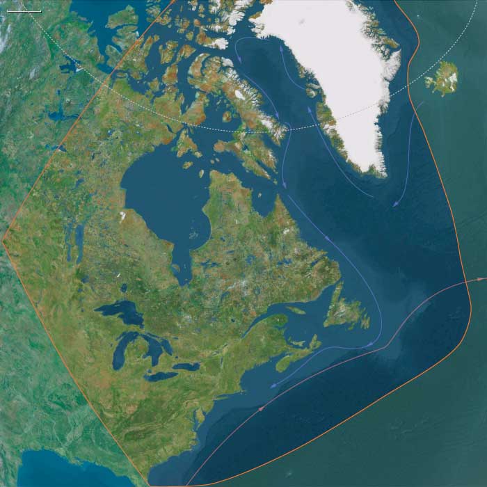
Northeastern North America
Related Events
Filter results
Showing 10 events out of 5065 total
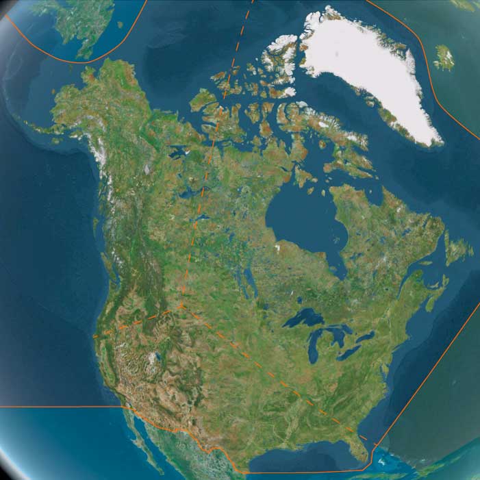
The Atlantic World, a pentagonal region encompassing one twelfth of the Earth, includes the Azores, Madeira, northwestern Europe (including western Denmark and western Norway), the British Isles, the Orkney Islands, the Shetland Islands, the Faroe Islands, Iceland, Greenland, Newfoundland, eastern and central North America, the northern section of Hispaniola, and several smaller island groups, notably Bermuda, the Bahamas, and the Turks and Caicos.
The eastern boundary, marked at 10° east longitude, divides Scandinavia into Eastern and Western sections, with Western Scandinavia oriented toward the North Atlantic and Eastern Scandinavia centered on the Baltic Sea Basin. This boundary also aligns with the historical eastern border of West Germany (1949–1990), before terminating in south-central Germany at its junction with the neighboring region to the southeast.
The western boundary, at 110° west longitude, cuts through Canada, separating the northern districts of Nunavut and the Northwest Territories from Alberta and Saskatchewan, approximately 75 miles south of the Alberta-Saskatchewan-Montana junction (48.1896851°N)—the northernmost point of the neighboring world to the southwest.
The southwestern boundary follows the division between the upper and lower Mississippi River Basin, then extends eastward into the Atlantic Ocean just south of Jacksonville, Florida, before terminating in northwestern Hispaniola.
HistoryAtlas contains 18,139 entries for The Atlantic World from the Paleolithic period to 1899.Narrow results by searching for a word or phrase or select from one or more of a dozen filters.
Around 55,000 years ago, global weather patterns begin to fluctuate dramatically, shifting from extreme cold to milder conditions and back within just a few decades.
By 50,000 years ago, the Wisconsin glaciation (known in Europe as the Würm glaciation) is well advanced. Expanding ice sheets in North America and Europe push climatic zones southward, transforming the temperate regions of Europe and North America into Arctic tundra-like landscapes. Meanwhile, rain bands typical of temperate zones shift south, reaching as far as northern Africa.
Neanderthals and Climate Adaptation
The Neanderthals, well adapted to cold climates with their barrel chests and stocky limbs, are better suited than Cro-Magnons to retain body heat. However, the rapid and unpredictable climate fluctuations cause ecological upheavals, replacing familiar plants and animals within a single lifetime—a shift to which Neanderthals struggle to adapt.
One major challenge is the replacement of forests by grasslands during the Mousterian Pluvial, an effect of the last Ice Age’s climatic shifts. This change disrupts the Neanderthals’ ambush-based hunting techniques, making it harder for them to secure food. As a result, large numbers of Neanderthals likely perish due to food scarcity and environmental stress, with the crisis peaking around 30,000 years ago.
Neanderthal Burial and Final Strongholds
Despite their decline, Neanderthals appear to be the first humans to intentionally bury their dead, often in simple graves. The last known traces of Mousterian culture, though lacking human remains, have been discovered at Gorham’s Cave on Gibraltar’s remote south-facing coast, dating between 30,000 and 24,500 years ago.
Possible Scenarios for Neanderthal Extinction
Several hypotheses attempt to explain the disappearance of the Neanderthals from the fossil record around 25,000 years ago:
-
Complete Extinction and Replacement: Neanderthals were a separate species from modern humans and became extinct due to climate change and/or competition with Homo sapiens, who expanded into their territories starting around 80,000 years ago. Anthropologist Jared Diamond suggests that violent conflict and displacement played a role in their demise.
-
Interbreeding and Absorption: Neanderthals were a contemporary subspecies that interbred with modern humans, gradually disappearing through genetic absorption.
-
Volcanic Catastrophe: A Campanian Ignimbrite super-eruption around 40,000 years ago, followed by a second eruption a few thousand years later, may have severely impacted Neanderthal populations. Evidence from Mezmaiskaya Cave in the Caucasus Mountains of southern Russia supports this theory, with mitochondrial DNA (mtDNA) analysis showing a distinct Neanderthal lineage separate from modern humans.
Energy Needs and Survival Challenges
Neanderthals had higher caloric requirements than any other known human species. They required 100 to 350 more calories per day than an anatomically modern human male (68.5 kg) or female (59.2 kg). This higher energy demand may have made them especially vulnerable when food sources became scarce, further contributing to their extinction.
Ultimately, by 25,000 years ago, Neanderthals disappear from the fossil record, leaving behind traces of their culture—but no direct descendants in the modern human genetic lineage.
Northern North America (49,293 – 28,578 BCE): Upper Pleistocene I — Ice Margins, Continental Gateways, and the First Migrations
Geographic and Environmental Context
During the late Pleistocene, Northern North America stretched across a landscape undergoing immense geological transformation. The advance and retreat of the Laurentide and Cordilleran ice sheets shaped a continent of alternating refugia and barriers. The region’s three great subregions—Northwestern, Northeastern, and Gulf & Western North America—each represented a distinctive interface between ice, land, and sea.
-
Northwestern North America bridged Asia and the Americas through the vast, exposed Beringian landmass. Grassy steppes, braided rivers, and polynyas along the Bering and Chukchi shelves linked Siberia to Alaska.
South of the continental ice, the Yukon and Kuskokwim basins opened to interior plains and the Gulf of Alaska’s wide glacial fjords. -
Northeastern North America was dominated by the Laurentide ice complex and its proglacial lakes—ancestral Iroquois, Algonquin, and Champlain basins—framed by newly deglaciated river valleys.
The Great Lakes corridor, the St. Lawrence–Hudson axis, and emerging Atlantic forelands formed the core of early post-glacial forager landscapes. -
Gulf & Western North America stretched from the Gulf Coast and Southern Plains across the deserts and canyons of the Southwest to the California littoral and Channel Islands.
Its mosaic of pluvial lakes, estuaries, and upwelling-rich coasts provided a warm-water counterpoint to the glacial north.
Together these zones composed a continental hinge between Ice-Age Eurasia and the Americas—each subregion a stage in the story of human dispersal and adaptation to the extremes of a changing world.
Climate and Environmental Shifts
The period encompassed the height of the Last Glacial Maximum. Yet regional variation produced a continent of contrasts:
-
In the Northwest, severe cold and aridity dominated inland Beringia, though coastal polynyas and summer grasslands offered productivity.
-
In the Northeast, alternating Dansgaard–Oeschger warm pulses and Heinrich cold snaps drove cycles of ice advance and retreat, spawning huge meltwater floods and loess plains.
-
In the Gulf & Western corridor, cooler but relatively stable climates supported pluvial lake systems and broad river valleys; along California’s margin, coastal upwelling made the Pacific rim one of the richest marine environments on Earth.
Low sea levels united Alaska and Siberia, widened the Pacific and Gulf shelves, and created continental interiors laced with temporary lakes, dunes, and glacial outwash plains—landscapes of constant flux but enduring opportunity.
Lifeways and Settlement Patterns
Northern North America during this interval was a frontier of mobility—a patchwork of exploratory movements, seasonal circuits, and, by the end of the epoch, enduring forager traditions.
-
In the Northwest, big-game hunters pursued mammoth, bison, and horse across the Beringian grasslands. Seasonal camps clustered at river confluences and bluff edges, while coastal groups ventured onto land-fast ice and ice-edge polynyas for seals and seabirds.
These were small, mobile bands accustomed to long circuits between steppe and shore. -
In the Northeast, later arrivals followed the retreating ice margins into proglacial valleys. Fluted-point traditions reveal expert hunters tracking caribou, elk, and deer across freshly deglaciated terrain.
Camps on river terraces and kame plains served as transient bases for butchery and tool repair rather than long-term villages. -
In the Gulf & Western regions, climatic moderation and ecological diversity allowed sustained occupation. Coastal foragers exploited shellfish, fish, and marine mammals along the expanded California and Gulf shelves, while interior hunters roamed canyonlands and pluvial basins in pursuit of camelids, horses, and later deer and pronghorn.
Rockshelters and spring-fed oases formed the nuclei of repeated seasonal use.
Across all three subregions, subsistence strategies balanced large-game hunting, aquatic foraging, and strategic mobility—the adaptive triad that defined Ice-Age resilience.
Technology and Material Culture
From Beringia to the Gulf, technology reflected shared Upper Paleolithic roots tempered by local innovation.
-
Northwestern assemblages featured blade and microblade industries in high-quality chert and obsidian, with inset composite points, burins, and sewing needles for tailored skins.
-
Northeastern traditions emphasized fluted projectile points, prismatic blades, and scrapers crafted from long-distance lithic sources, signaling wide-ranging exchange and expertise in stone selection.
-
Gulf & Western toolkits relied on flake–blade technology, early hafting, fire use, and pigment processing, suited to mixed desert, canyon, and littoral ecologies.
Throughout the region, ochre pigments and personal ornaments (drilled teeth, shells, beads) reveal symbolic continuity with the larger circumpolar Upper Paleolithic world.
Movement and Interaction Corridors
Northern North America’s human geography was defined by corridors of ice, water, and stone:
-
The Beringian steppe and the Yukon–Mackenzie trench formed the first continental highway, linking Siberia to interior North America.
-
The ice-free Pacific coast—the embryonic “kelp highway”—offered a maritime alternative, dotted with refugia along Alaska’s and British Columbia’s fjorded shores.
-
As deglaciation advanced, the St. Lawrence, Great Lakes, and Mississippi basins became arteries of migration and trade.
-
Farther south, the Rio Grande–Gila–Colorado network and the Gulf estuaries tied the interior to marine resources.
Through these routes, populations spread, merged, and diverged, laying the demographic foundations of later Holocene cultural provinces.
Cultural and Symbolic Expressions
Symbolic life across Northern North America echoed Eurasian antecedents yet developed distinctive local signatures.
Ochre-stained hearths, portable ornaments, and structured camp layouts indicate social memory and ritual behavior.
In both Beringia and the Great Lakes heartland, burials with pigment and grave goods suggest shared beliefs in ancestral continuity.
These expressions, modest in scale yet rich in meaning, anchored social cohesion in landscapes that demanded both cooperation and constant movement.
Environmental Adaptation and Resilience
Resilience was achieved through mobility, diversification, and knowledge of seasonality:
-
Layered clothing, snow shelters, and fire technology extended human presence deep into subarctic zones.
-
In milder belts, foragers exploited estuaries, riverine wetlands, and pluvial lakes, moving along altitudinal and hydrological gradients.
-
Coastal populations learned to synchronize with marine cycles; interior hunters tracked herd migrations across vast steppes.
This adaptive plasticity allowed human groups to colonize environments ranging from glacial fjords to desert basins—a testament to the flexibility that made the Americas habitable at the height of global cold.
Transition Toward the Last Glacial Maximum
By 28,578 BCE, Northern North America stood at the threshold of transformation.
Ice sheets approached their greatest extent, closing interior corridors but leaving narrow coastal and riverine refuges.
Populations in Beringia maintained a tenuous bridge between continents, while others expanded southward along the Pacific and Gulf margins into unglaciated refugia.
The region thus embodied the Twelve Worlds principle: a set of distinct yet interdependent subregions—each self-contained, each connected through migration, exchange, and shared adaptation—that together forged the human foothold on a glacial continent.
Northeastern North America (49,293–28,578 BCE) Upper Pleistocene I — Paleoindian Arrival, Fluted Horizons, and River Terraces
Geographic and Environmental Context
Northeastern North America includes the Atlantic coast from Jacksonville, FL to St. John’s, NL; Greenland; the Canadian Arctic; all Canadian provinces east to the Saskatchewan–Alberta border; and, within the U.S., the Old South, the Appalachian Plateau, Midwest & Great Lakes (including Driftless Area, Midwest Lowlands, Tallgrass Prairie, Big Woods, Drift Prairie, Aspen Parkland).
Anchors: Chesapeake–Delaware–Hudson–Gulf of Maine coasts; St. Lawrence–Quebec–Montreal; Great Lakes & Ohio–Illinois–Mississippi valleys; Appalachian Plateau (Pittsburgh–Knoxville); Hudson Bay rim; Arctic (Baffin, Foxe, Labrador); Greenland (future Norse Eastern/Western Settlements).
-
Laurentide ice lobes retreated unevenly; proglacial Lake Iroquois/Algonquin ancestors formed; coastal outwash plains expanded.
Climate & Environmental Shifts
-
Cold, dry; abrupt Dansgaard–Oeschger oscillations; productive river–lake ecotones as ice withdrew.
Subsistence & Settlement
-
Paleoindian big-game foragers (fluted points) hunted mammoth/mastodon (earlier), caribou, then elk/deer; camps on terraces and kame plains.
Technology & Material Culture
-
Clovis–Folsom-like fluted points → regional fluted series; prismatic blades, end-scrapers; bone/antler tools.
Movement & Interaction Corridors
-
Champlain–Hudson, St. Lawrence, Ohio–Tennessee, Great Lakes strandlines; Atlantic forelands.
Cultural & Symbolic Expressions
-
Red-ochre treatment; curated toolkits; long-distance raw material transport (cherts, obsidian rare).
Environmental Adaptation & Resilience
-
High mobility across deglaciating mosaics buffered risk.
Transition
By 28,578 BCE, mobile foragers had mapped post-glacial corridors.
Ancestors of Clovis people might have lived on the eastern coast of North America, as suggested by the archaeological sites at Topper in the state of South Carolina, U.S.A., dated fifty thousand years BP, and ...
...the Meadowcroft Rockshelter located near Avella in Washington County, in southwestern Pennsylvania, United States, dated to sixteen thousand years BP.
These discoveries have raised doubts about the "Clovis First" theory, and have led to alternative proposals for the routes of colonization and the diffusion of culture through the continent, in a heated dispute that has not been solved.
Northern North America (28,577 – 7,822 BCE): Upper Pleistocene II → Early Holocene — Deglaciation, Kelp Highways, and Pluvial Heartlands
Geographic & Environmental Context
From the Bering Strait and Aleutians to the Gulf of Alaska, down the Inside Passage–Haida Gwaii–Vancouver Island chain and along the Klamath–Redwood coast, and across the continent through the Yukon–Fraser–Columbia–Mississippi drainages to the Great Lakes–St. Lawrence, Hudson Bay, and the Mid-Atlantic–New England shore, Northern North America took shape as ice withdrew and seas rose.
Three interlocking spheres structured lifeways:
-
Northwestern North America — The Cordilleran–Beringian gateway, with Brooks Range and North Slopetundras, Yukon–Kuskokwim and Copper–Cook Inlet basins, the Gulf of Alaska and Aleutian arcs, and the Southeast Alaska–Haida Gwaii–outer BC fjordlands. Late-opening ice-free corridors and a sheltering, resource-rich kelp-forest coast defined movement and subsistence.
-
Gulf & Western North America — The California Current coast (Channel Islands to Puget/Salish), the Lower Mississippi and Gulf Coast estuaries, the Southern Plains, Colorado Plateau, and the Great Basin of pluvial lakes. Here, estuary chains, canyon springs, and inland basins created a patchwork of productive niches.
-
Northeastern North America — The Chesapeake–Delaware–Hudson–Gulf of Maine margins, Great Lakes–Ohio–Mississippi valleys, Appalachian ridge-and-valley, Upper St. Lawrence–Quebec, and the Baffin–Labrador rim. As the Ancylus/Champlain seas waxed and waned and isostatic rebound re-shaped coastlines, mixed forest–water ecotones proliferated.
Across all three spheres, postglacial estuaries, high-latitude tundra–taiga mosaics, and greening loess plainscreated an integrated coast–river–lake system that drew people into longer stays at dependable water-edge nodes.
Climate & Environmental Shifts
-
Bølling–Allerød (c. 14.7–12.9 ka): Warmer, wetter conditions greened interior loess plains, invigorated riverine and lacustrine productivity, and stabilized nearshore kelp forests; small ice-free coastal pockets opened along the Gulf of Alaska and SE Alaska–BC fjords.
-
Younger Dryas (c. 12.9–11.7 ka): A sharp cold–dry pulse renewed steppe/tundra, pinched interior water sources, and funneled people to fjord mouths, estuaries, and spring-fed refugia where marine and riparian resources remained reliable.
-
Early Holocene (post-11.7 ka): Rapid warming and rising seas flooded outer shelves, forming the modern estuaries and sounds; oak–hazel–elm forests raced poleward; salmon-bearing rivers stabilized; Great Basinlakes still dotted the interior though retreating.
This cadence favored dual mobility—coast ↔ interior, lake ↔ plain—while encouraging semisedentary anchoring at rich aquatic nodes.
Subsistence & Settlement
A continent-spanning broad-spectrum foraging economy matured, increasingly underwritten by fisheries and wetland yields:
-
Northwestern Coast & Beringia: Foragers moved fjord by fjord along a “kelp highway,” harvesting rockfish, salmon, shellfish, sea urchins, waterfowl, and seals, with dugout/skin boats, tailored parkas, and sinew-sealed seams enabling year-round littoral rounds. Interior camps on river benches and rock shelters targeted caribou, elk, and whitefish/salmon at crossings; by the Early Holocene, weirs and fish traps appear, and stays on raised marine terraces lengthened toward semisedentism.
-
Gulf & Western Interior: Along the Lower Mississippi and Gulf estuaries, semirecurrent camps clustered on natural levees, working oyster bars, mullet/menhaden runs, and back-swamp fauna. On the California–Channel Islands and outer coast, dense shell-middens, canoe/raft use, and targeted seabird/sea-mammalharvests foreshadow later maritime societies. In the Great Basin and Southwest, shore camps on pluvial lakescaptured fish and waterfowl, while pronghorn and small-game drives, geophyte digging, and seed processing rounded out diets.
-
Northeast & Great Lakes: Estuary and bay-head hamlets on the Severn–Delaware–Hudson–Maine coasts built early shell heaps; interior Great Lakes–river communities fished salmonids and sturgeon, hunted deer and moose, and gathered hazelnut, oak mast, and berries. Camps were seasonal but repeatedly reoccupied on dune ridges and terrace knolls, laying down deep middens and cemeteries.
Across all zones, semisedentary seasonality—anchoring at rich nodes with radiating forays—became a hallmark of the period.
Technology & Material Culture
Light, adaptable, and increasingly specialized toolkits supported both mobility and storage:
-
Lithics: Persistent microblade industries in the NW; widespread backed bladelets, trapezes, and notched/side-notched points elsewhere.
-
Aquatic gear: Bone/antler harpoons (often toggling), gorges, barbed points; stake-weirs, woven fish baskets, and net floats/sinkers; dugouts and skin boats on protected waters.
-
Processing & containers: Grinding slabs and handstones for seeds/geophytes; drying racks and smokehouses for fish/meat; organic containers (bark, skin); early use of blubber oils for waterproofing gear.
-
Ornaments & pigments: Beads of shell, bone, jet/amber, and teeth; ochre widely used in body/ritual contexts; carved bone/antler animal motifs signal deepening predator–prey cosmologies.
Movement & Interaction Corridors
A web of redundant routes ensured resilience:
-
Coastal: stepwise Southeast Alaska–Haida Gwaii–Vancouver Island–Puget; Klamath–Channel Islands arcs; short-hop cabotage between estuaries.
-
Riverine: Yukon, Fraser, Columbia, Sacramento–San Joaquin, Mississippi–Ohio–Illinois, St. Lawrence—all served as driftways, trade channels, and seasonal migration guides.
-
Overland: Drakensberg-style highland corridors in the Rockies and Appalachians; portages binding watersheds; interior Great Plains and boreal routes linking basins.
These corridors moved not only people and tools but also dried fish, fat, hides, pigments, and ideas, knitting together far-flung bands.
Cultural & Symbolic Expressions
Symbolic life was entwined with water, animals, and place:
-
Rock art and pecked engravings mark canyon walls and coastal shelters; imagery of salmon, seals, caribou, bear, and watercraft points to a cosmology of reciprocity with “animal persons.”
-
Red-ochre burials with curated toolkits and ornaments cluster near estuaries, lake margins, and river terraces, fixing lineage rights to critical nodes.
-
Midden mounds and lacustrine deposits served as ceremonial foci and archives of feast and return, materializing ancestral claims over weirs, groves, and crossings.
Environmental Adaptation & Resilience
Forager strategies balanced anchoring with agility:
-
Coastal–interior duality ensured protein continuity through climatic pulses;
-
Storage of oils, dried fish/meat, and nuts underwrote winter and drought survival;
-
Fine-grained seasonal scheduling tracked flood pulses, salmon runs, waterfowl migrations, and mast years;
-
Territorial norms around weirs, springs, and beaches managed access and minimized conflict.
These practices allowed populations to ride out the Younger Dryas setback and capitalize on Early Holocene productivity.
Long-Term Significance
By 7,822 BCE, Northern North America had coalesced into a storage-rich, water-anchored forager world: salmon estuaries and kelp-forest coasts in the northwest, pluvial-lake and estuary chains across the west and Gulf, and forest–river–bay mosaics in the northeast.
This emergent system—portfolio subsistence, semi-sedentary nodes with radiating rounds, engineered fisheries and food storage, and ritualized tenure over key waters—formed the durable substrate from which later Northwest Coast maritime societies, Archaic mound-building traditions, and riverine trade networks would grow as the Holocene unfolded.
Northeastern North America (28,577 to 7822 BCE) Terminal Pleistocene — Early Holocene — Archaic Foundations
Geographic and Environmental Context
Northeastern North America includes the Atlantic coast from Jacksonville, FL to St. John’s, NL; Greenland; the Canadian Arctic; all Canadian provinces east to the Saskatchewan–Alberta border; and, within the U.S., the Old South, the Appalachian Plateau, Midwest & Great Lakes (including Driftless Area, Midwest Lowlands, Tallgrass Prairie, Big Woods, Drift Prairie, Aspen Parkland).
Anchors: Chesapeake–Delaware–Hudson–Gulf of Maine coasts; St. Lawrence–Quebec–Montreal; Great Lakes & Ohio–Illinois–Mississippi valleys; Appalachian Plateau (Pittsburgh–Knoxville); Hudson Bay rim; Arctic (Baffin, Foxe, Labrador); Greenland (future Norse Eastern/Western Settlements).
Climate & Environmental Shifts
-
Bølling–Allerød → Younger Dryas → Holocene: forests expanded; river–lake productivity rose.
Subsistence & Settlement
-
Early Archaic broad-spectrum foraging; estuarine shell-heaps on Mid-Atlantic/New England; interior fish–deer economies.
Technology & Material Culture
-
Notched/side-notched points; adzes; groundstones appear; dugouts on rivers/estuaries.
Movement & Interaction Corridors
-
St. Lawrence & Great Lakes navigation; Appalachian ridge–valley routes; Chesapeake–Narragansett–Gulf of Maine canoe circuits.
Cultural & Symbolic Expressions
-
Shell heap feasts; early mound/earthwork precursors in interior.
Environmental Adaptation & Resilience
-
River–bay storage buffered seasonality; coastal storm evacuation by canoe.
Transition
By 7,822 BCE, Archaic adaptations were well-established coast–interior.
The End of the Mousterian Pluvial and the Influence of the Laurentide Ice Sheet
The same climatic influences that had created the Mousterian Pluvial—a period of increased rainfall that transformed North Africa into a more hospitable environment—also appear to have contributed to its decline. During its peak development, between 30,000 and 18,000 years ago, a major shift in global climate patterns was driven by the expansion of the Laurentide Ice Sheet in North America.
The Laurentide Ice Sheet and Its Impact on Global Climate
- The Laurentide Ice Sheet, which covered vast portions of North America, reached an altitude of 1,750 meters (more than one mile), altering atmospheric circulation on a large scale.
- Its massive size allowed it to generate its own long-term weather patterns, which had far-reaching effects on the Northern Hemisphere’s climate.
The Jet Stream Split and the Return to Aridity
- The jet stream, the high-altitude air current that controls weather systems, was disrupted by the Laurentide Ice Sheet, causing it to split into two branches.
- This new dominant weather pattern resulted in harsher climatic conditions in multiple regions, including Central Asia and the Middle East.
- In North Africa, the climate began shifting away from the humid conditions of the Mousterian Pluvial, leading to a return of aridity.
Consequences for Human and Ecological Landscapes
- As rainfall decreased, lakes and rivers that had once supported human populations and wildlife began to dry up.
- This change forced human groups to migrate, seeking more sustainable environments, while desertification expanded across the Sahara.
- The end of the Mousterian Pluvial marks an important transition in prehistoric climate history, as it reshaped the ecosystems of North Africa and surrounding regions, influencing the movements and adaptations of early human populations.
These climatic shifts, triggered by glacial expansion in the Northern Hemisphere, demonstrate the interconnected nature of global climate systems, showing how distant geological events could dramatically alter environments thousands of kilometers away.
Advancements in Weapon Construction by 18,000 BP
By 18,000 BP, early humans had made significant technological advancements in weapon-making, improving the efficiency and accuracy of their hunting tools.
Innovations in Projectile Construction
-
Flint Points Secured with Sinews
- Flint projectile points were now firmly attached to split wooden shafts using sinews as binding material.
- This technique increased durability and impact strength, making weapons more effective for hunting large game.
-
The Use of Fletching for Greater Accuracy
- Feathers were carefully glued and bound to projectile shafts, introducing fletching—a technique that improved stability and accuracy in flight.
- This innovation allowed projectiles to travel farther and hit targets more precisely, making hunting more efficient and reliable.
Impact on Upper Paleolithic Hunting and Warfare
- These advancements enhanced hunting efficiency, leading to greater success in capturing fast-moving prey.
- The use of composite tools, with multiple materials such as wood, sinew, stone, and feathers, reflects increasing technological sophistication.
- The refinements in projectile design paved the way for the later development of bows and arrows, revolutionizing prehistoric hunting and combat strategies.
By 18,000 BP, humans were not only mastering stone tool production but also incorporating aerodynamic principles and multi-material engineering, demonstrating an advanced understanding of physics, materials science, and hunting strategy.