West Indies
Related Events
Filter results
Showing 10 events out of 1224 total
The Atlantic World, a pentagonal region encompassing one twelfth of the Earth, includes the Azores, Madeira, northwestern Europe (including western Denmark and western Norway), the British Isles, the Orkney Islands, the Shetland Islands, the Faroe Islands, Iceland, Greenland, Newfoundland, eastern and central North America, the northern section of Hispaniola, and several smaller island groups, notably Bermuda, the Bahamas, and the Turks and Caicos.
The eastern boundary, marked at 10° east longitude, divides Scandinavia into Eastern and Western sections, with Western Scandinavia oriented toward the North Atlantic and Eastern Scandinavia centered on the Baltic Sea Basin. This boundary also aligns with the historical eastern border of West Germany (1949–1990), before terminating in south-central Germany at its junction with the neighboring region to the southeast.
The western boundary, at 110° west longitude, cuts through Canada, separating the northern districts of Nunavut and the Northwest Territories from Alberta and Saskatchewan, approximately 75 miles south of the Alberta-Saskatchewan-Montana junction (48.1896851°N)—the northernmost point of the neighboring world to the southwest.
The southwestern boundary follows the division between the upper and lower Mississippi River Basin, then extends eastward into the Atlantic Ocean just south of Jacksonville, Florida, before terminating in northwestern Hispaniola.
HistoryAtlas contains 18,139 entries for The Atlantic World from the Paleolithic period to 1899.Narrow results by searching for a word or phrase or select from one or more of a dozen filters.
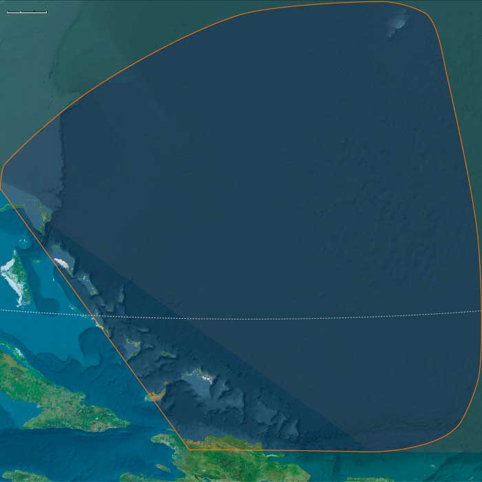
One twelfth of the Earth encompasses most of the South American continent, Puerto Rico, the Lesser Antilles, and the majority of Hispaniola—including southeastern Haiti and all but the northern coast of the Dominican Republic. This region, designated South America and the Eastern Isles, explicitly excludes Patagonia.
The northwestern boundary separates Panama, the southernmost country of Central America, from Colombia.
Within this world are the entirety of Venezuela, Guyana, Suriname, French Guiana, Brazil, Uruguay, Bolivia, and Peru. Argentina and Chile also belong largely to this region, though their sparsely populated southern reaches—Patagonia—are part of the subcontinent.
HistoryAtlas contains 2,652 entries for South America and the Eastern Isles from the Paleolithic period to 1899.
Narrow results by searching for a word or phrase or select from one or more of a dozen filters.
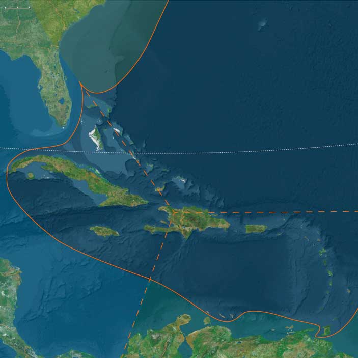
The Far West, encompassing the southwestern section of the North American continent along with the Caribbean Sea, the Gulf of Mexico, and the Pacific Ocean, includes the Galápagos Islands, the five countries of Central America, Mexico, and the Gulf and Western United States, as well as Cuba, Jamaica, the Cayman Islands, and the northwestern and southwestern regions of Haiti on Hispaniola.
Within the United States, the following states are entirely within The Far West:
Florida, Mississippi, Louisiana, Arkansas, Texas, Oklahoma, Kansas, Nebraska, Colorado, Wyoming, New Mexico, Arizona, California, and Nevada.
Portions of other states also belong to this world, including:
- Southwestern Georgia
- Most of Alabama
- Southeastern Tennessee
- Southeastern Missouri
- Southwestern South Dakota
- Most of Montana, except its northeastern and northwestern corners
- Southern Idaho
- Southeastern Oregon
HistoryAtlas contains 3707 entries for The Far West from the Paleolithic period to 1899.
Narrow results by searching for a word or phrase or select from one or more of a dozen filters.
The West Indies (49,293–28,578 BCE): Upper Pleistocene I — Exposed Banks, Reef Arcs, and Island Worlds Without People
Geographic and Environmental Context
During the late Pleistocene, the West Indian archipelagos—stretching from the Bahama banks to Trinidad—were vast, emergent shelves divided into three natural subregions that would later become cultural zones: the Northern, Eastern, and Western West Indies.
-
The Northern West Indies comprised the Bahamas and Turks & Caicos banks and the northern coast of Hispaniola.
Sea levels ~100 m lower than today fused many of the present islands into broad limestone plains dotted with sinkholes and dune fields. The Cibao Valley and the Massif du Nord of Hispaniola formed the rugged southern margin of this shelf sea. -
The Eastern West Indies traced a long volcanic and carbonate arc from Puerto Rico and the Virgin Islands through the Lesser Antilles to Trinidad & Tobago, where the chain met the South American shelf.
Active volcanoes alternated with uplifted reef terraces and deep inter-island channels shaped by the northeast trades. -
The Western West Indies included Cuba, Jamaica, the Cayman Ridge, and western Hispaniola, flanked by the deep Cayman Trench and the Windward Passage.
Here, broad banks and narrow straits created a labyrinth of shelves, slopes, and enclosed lagoons fringed by coral and seagrass ecosystems.
These three subregions were already differentiated by geology and oceanography: the Northern banks were broad, flat, and porous; the Eastern arc steep and windward; the Western ridge mountainous and trench-bound. Together they formed the tropical hinge between the Atlantic and Caribbean basins—an archipelago before humanity, alive only with reefs, birds, and tides.
Climate and Environmental Shifts
The interval coincided with the approach to the Last Glacial Maximum, producing climatic contrasts across latitude and elevation:
-
Sea level fall of 90–110 m exposed vast carbonate platforms in the Bahamas and Caicos and broadened coastal plains around Cuba and Hispaniola.
-
Trade winds intensified as global temperature gradients sharpened, driving upwelling and enhancing nutrient flows along windward coasts.
-
Cooler sea-surface temperatures slowed coral accretion but favored calcareous algae, sponges, and mollusks, maintaining high marine productivity.
-
Periodic northers and dry seasons reduced rainfall, particularly over the northern and western islands, while volcanic highlands in the east retained moist forests and orographic rainfall.
The result was a gradient from arid limestone plains in the north to humid volcanic slopes in the east, already anticipating the ecological zones that would later support very different island societies.
Biotic Assemblages and Ecological Structure
With no humans yet present, the Pleistocene West Indies were laboratories of insular evolution:
-
Seabirds dominated: vast rookeries of boobies, frigatebirds, shearwaters, and petrels nested on cliffs and dunes from the Bahamas to the Grenadines.
-
Reptiles and amphibians were diverse, including large lizards and ground-dwelling tortoises on the larger banks.
-
Mammals were limited to endemic rodents and small insectivores; ground sloths and monkeys persisted on Cuba and Hispaniola into later millennia.
-
Marine ecosystems—reef flats, turtle-nesting beaches, mangrove-lined lagoons—functioned at full productivity, unaltered by hunting or fire.
-
Beneath the islands, freshwater lenses formed within porous limestones, supporting vegetation pockets and stabilizing the water table.
These pristine ecologies, organized by rainfall and ocean currents rather than human movement, set the template for all later biological and cultural differentiation in the Caribbean.
Movement and Interaction Corridors
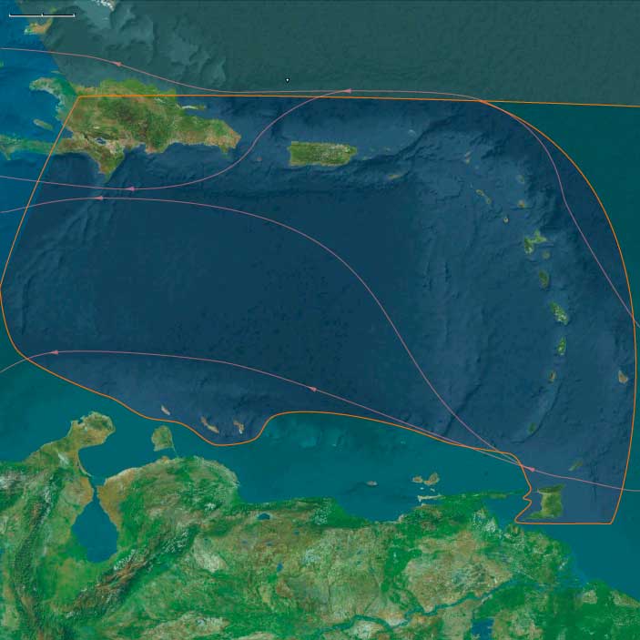
Although uninhabited, the region was threaded by powerful oceanic highways that would later shape both migration and commerce:
-
The North Equatorial Current and its offshoot, the Florida Current, swept westward across the Lesser Antilles and northward through the Bahamas toward the Gulf Stream.
-
Countercurrents and eddies along the Caribbean side of the arc distributed larvae, seeds, and drifting vegetation between islands, knitting their ecosystems together.
-
These same pathways would eventually become the maritime corridors of human voyaging; in this epoch, they served only seabirds and sea turtles, tracing the routes that future canoes would follow.
Cultural and Symbolic Dimensions
No human symbolic system had yet entered this landscape, yet the environment itself encoded rhythms and structures that later peoples would mythologize: the circularity of atolls, the seasonal pulse of trade winds, the nesting cycles of seabirds, the periodic flooding and drying of lagoons.
These were the physical archetypes of later Caribbean cosmologies—worlds of tide and return, absence and reemergence.
Environmental Adaptation and Resilience
In biological terms, the archipelago functioned as a self-balancing triad:
-
Northern carbonate banks acted as vast nurseries for marine life, their freshwater lenses and seagrass meadows stabilizing regional nutrient budgets.
-
Eastern volcanic islands provided vertical zonation—reef, mangrove, forest—that buffered storms and erosion.
-
Western highlands generated sediment and nutrients feeding neighboring shelves.
Interconnected by wind and current, these systems maintained equilibrium without external disturbance. Each island was autonomous yet ecologically interdependent—an early analogue of the inter-island diversity that would later underpin cultural resilience in the peopled Caribbean.
Transition Toward the Last Glacial Maximum
By 28,578 BCE, the West Indies were an archipelago of abundance awaiting discovery.
Emergent banks and volcanic ridges, swept by steady trades, supported some of the most productive reef and seabird ecosystems on Earth.
No human footprints yet marked their dunes, but the stage was set: broad shelves for future navigation, fertile soils for cultivation, and ecological gradients for diversification.
In this epoch, the Caribbean existed as a network of natural worlds, poised—like the other realms of The Twelve Worlds—to become human worlds when the seas rose again.
Northern West Indies (49,293–28,578 BCE) Upper Pleistocene I — Reef Benches, Limestone Lenses, and Seabird Realms (No People)
Geographic and Environmental Context
Northern West Indies includes the Outer Bahamas (Lucayan archipelago), the Turks & Caicos Islands, and northern Hispaniola — northern Haiti (Cap-Haïtien, Massif du Nord) and the Cibao/north coast of the Dominican Republic (Santiago de los Caballeros, Puerto Plata).
Anchors: Andros–Abaco–Eleuthera–San Salvador–Exuma banks, Turks & Caicos banks and passes, Cap-Haïtien–Massif du Nord, Cibao–Puerto Plata–Santiago river valleys and coastal shelves.
-
Sea level ~100 m lower exposed broad carbonate benches and dune fields on Bahama and Caicos banks; northern Hispaniola held narrow shelf and uplifted limestone foothills.
Climate & Environmental Shifts
-
LGM cooling strengthened winter trades and lowered SSTs; upwelling pulses still supported reef productivity.
Subsistence & Settlement
-
No human occupation; seabird/turtle rookeries and shallow lagoons formed dense trophic webs.
Technology & Material Culture — N/A.
Movement & Interaction Corridors
-
Ocean currents (Florida Current/North Equatorial) set cross-bank drift patterns; purely ecological connectivity.
Cultural & Symbolic Expressions — N/A.
Environmental Adaptation & Resilience
-
Pristine island biotas matured on freshwater lenses beneath the larger cays.
Transition
By 28,578 BCE, the banks and north Hispaniola coast were high-productivity carbonate landscapes awaiting people.
Eastern West Indies (49,293–28,578 BCE) Upper Pleistocene I — Arc Volcanoes, Reef Slopes, and Windward Shelves (No People)
Geographic and Environmental Context
Eastern West Indies includes eastern Haiti and most of the Dominican Republic (excluding the northern fringe), Puerto Rico, the Virgin Islands, the Lesser Antilles (Anguilla → Aruba), and Trinidad & Tobago
Anchors: Vega Real–Santo Domingo valleys; Puerto Rico (Cordillera Central & coastal plains); Virgin Islands passes; Leewards/Windwards (Guadeloupe–Dominica–Martinique–St. Lucia–Barbados–St. Vincent–Grenada–Aruba); Trinidad & Tobago at the Orinoco gate.
Climate & Environmental Shifts
-
LGM cooling; lower sea level expanded near-shore benches and cays.
Subsistence, Technology, Corridors, Symbolism — N/A.
Adaptation & Transition -
Pristine; high marine productivity, unpeopled.
Western West Indies (49,293–28,578 BCE) Upper Pleistocene I — Bank Shelves, Seabird Rookeries (No People)
Geographic and Environmental Context
Western West Indies includes Cuba and its surrounding isles, Jamaica, the Cayman Islands, and western Haiti — Tortuga Island, Port-de-Paix, western Massif du Nord, Gonâve Gulf & Île de la Gonâve, western Tiburon Peninsula (including Île à Vache).
Anchors: Windward Passage, Jamaica Channel, Tortuga–Port-de-Paix corridor, Gonâve Gulf, Cayman Ridge, northern Cuba shelves.
- Exposed shelves and benches; high marine productivity; unpopulated.
West Indies (28,577 – 7,822 BCE): Upper Pleistocene II → Early Holocene — Deglacial Shores, Mangrove Margins, and the First Island Stopovers
Geographic & Environmental Context
Spanning the Lucayan (Outer Bahamas) and Turks & Caicos banks, the Greater Antillean north coast (north Haiti’s Cap-Haïtien–Massif du Nord and the Cibao–Puerto Plata–Santiago corridor), the Puerto Rico–Virgin arc, the Lesser Antilles (Anguilla → Aruba), and Trinidad & Tobago at the Orinoco gate, the West Indies entered the Early Holocene as a necklace of rising reefs and widening lagoons.
As postglacial seas climbed ~60–80 m toward near-modern levels, exposed carbonate benches on the Bahama and Caicos platforms flooded into back-reef lagoons cut by new tidal passes; mangrove skirts thickened on leeward rims. Along northern Hispaniola, faulted ranges (Massif du Nord) shed sediments into incising Cibao rivers, building fertile fans against an enlarging shelf.
Across the eastern (Hispaniola–Puerto Rico–Lesser Antilles) and western (Cuba–Jamaica–Caymans–Gonâve) arcs, rocky promontories framed new embayments, while Trinidad & Tobago stood as the western hinge between island and continent. The Bahama–Caicos platforms remained vast, low, and storm-swept—physically inviting but thin-soiled and freshwater-poor.
Climate & Environmental Shifts
-
Bølling–Allerød (c. 14.7–12.9 ka): Regional seas warmed and coasts moistened; coral growth accelerated, reef flats aggraded toward sea level; mangroves colonized freshly flooded margins.
-
Younger Dryas (c. 12.9–11.7 ka): A short, cool–dry reversal lowered effective moisture and tempered reef accretion; dunes reactivated and lagoons periodically breached under stronger storms.
-
Early Holocene (post-11.7 ka): Monsoonal stability returned; trade-wind regimes regularized swell and rainfall; back-reef and mangrove systems stabilized, setting the physical template for later settlement.
Subsistence & Settlement
Occupation was sparse and episodic, with strongest signals at north-coast Hispaniola and Trinidad & Tobago; most outer banks and smaller islands (e.g., Turks & Caicos, Bahamas, many Lesser Antilles) show, at most, transient landfalls without durable villages.
-
Northern West Indies (Lucayan–Turks & Caicos–north Hispaniola):
• Hispaniola (north coast/Cibao): Preceramic Archaic foragers likely established semi-recurrent river-mouth camps, exploiting sturgeon-like fishes, reef and lagoon fish, mollusks, waterfowl, and deer/boar/ibex analogues in nearby foothills; shell scatters and simple hearths hint at feasting episodes.
• Bahamas & Turks/ Caicos: Cays and bank edges served as canoe stops and opportunistic foraging grounds (conch, turtles, seabirds); freshwater scarcity and storm-prone strandplains precluded stable occupation. -
Eastern West Indies (Hispaniola E., Puerto Rico, Virgin & Lesser Antilles, Trinidad & Tobago):
Seasonal shore stations formed at lagoon mouths and coves, especially where mangrove channels and fringe reefs concentrated resources. Trinidad & Tobago, tight to the Orinoco outflow and rich in estuarine fish, manatees, and turtles, were probable gateway nodes for ephemeral camps and knowledge transfer between mainland and islands. -
Western West Indies (Cuba–Jamaica–Caymans–W. Hispaniola):
Deglacial pass formation (e.g., Windward Passage, Jamaica Channel) created short-hop routes. Forager groups from the Greater Antilles likely made intermittent use of north-Cuba and Tortuga–Gonâve shorelines for marine harvests and lithic forays, leaving light, discontinuous scatters rather than permanent villages.
Technology & Material Culture
A preceramic, highly mobile toolkit prevailed:
-
Flaked stone: simple cores, expedient flakes, backed bladelets, scrapers for butchery and wood-working.
-
Bone tools: points, gorges, barbs for fish and turtle capture; awls/needles for skin and cordage work.
-
Watercraft: rafts and early dugout/dug-plank craft inferred from cross-channel movements and bank-edge stopovers.
-
Ornaments: shell beads and drilled teeth appear in coastal contexts; ochre used in body/ritual marking.
Movement & Interaction Corridors
The archipelago functioned as a stepping-stone seaway:
-
Hispaniola’s north coast as a launch/landfall interface with protected inlets and nearby freshwater.
-
Turks & Caicos and Bahama banks as seasonal corridors, utilized in calm-season windows, but largely uninhabited.
-
Orinoco–Trinidad–Lesser Antilles as a western Atlantic gateway, enabling episodic east–west drift and directed canoeing.
-
Windward Passage / Jamaica Channel as tentative links into western arcs (Cuba–Jamaica–Caymans), primarily for opportunistic forays.
Cultural & Symbolic Expressions
Where occupation occurred, waterfront places became mnemonic anchors:
-
Shell accumulations mark communal harvests and feasts at river mouths and coves, inscribing early claims to landing places.
-
Simple ornaments in coastal sites imply emergent identities and ties across shores.
-
In the absence of sustained settlement on the banks and many outer isles, natural rhythms—turtle crawls, seabird rookeries, seasonal fish runs—formed the ‘calendar’ of place.
Environmental Adaptation & Resilience
Foragers balanced littoral and riverine portfolios to ride climatic swings:
-
Mangrove-fringe shellfish and reef fishes buffered against cool/dry spells; riverine fish and riparian game underwrote lean seasons.
-
Mobility and short-stay landfalls mitigated storm risk on low, water-poor banks.
-
Knowledge of passes, currents, and bank hydrology—the seeds of later navigational traditions—was itself an adaptive asset.
Long-Term Significance
By 7,822 BCE, the West Indies remained lightly and unevenly touched by people: north-coast Hispaniola sustained semi-recurrent Archaic camps, Trinidad & Tobago functioned as a continental bridge, and the Bahama–Caicos–Lesser Antilles served mainly as episodic stopovers.
Yet the physical groundwork was laid—back-reef lagoons, mangrove larders, and bank-edge routes—for the later Ceramic-age colonization of the archipelago. The region’s defining pattern was already in motion: mobility across an aquatic landscape, with estuaries and reefs as granaries and coves as memory-sites that would guide the great peopling to come.
Northern West Indies (28,577–7,822 BCE) Upper Pleistocene II — Deglaciation, Lagoon Formation, and Mangrove Fringes (Sparse/Episodic Use)
Northern West Indies includes the Outer Bahamas (Lucayan archipelago), the Turks & Caicos Islands, and northern Hispaniola — northern Haiti (Cap-Haïtien, Massif du Nord) and the Cibao/north coast of the Dominican Republic (Santiago de los Caballeros, Puerto Plata).
Anchors: Andros–Abaco–Eleuthera–San Salvador–Exuma banks, Turks & Caicos banks and passes, Cap-Haïtien–Massif du Nord, Cibao–Puerto Plata–Santiago river valleys and coastal shelves.
-
Rapid sea rise flooded benches into back-reef lagoons and pass channels; mangroves expanded on leeward rims; Cibao rivers incised into fertile alluvium.
Climate & Environmental Shifts
-
Bølling–Allerød warmth moistened coasts; Younger Dryas brief cool/dry; Early Holocene stabilized rainfall and reef accretion.
Subsistence & Settlement
-
Regional Archaic foragers (Greater Antilles) likely reached north Hispaniola’s river mouths; Bahama/Caicos use was episodic at most (canoe stops, no firm villages yet).
Technology & Material Culture
-
Preceramic flake toolkits; shell/stone scrapers; bone points; raft/dugout precursors regionally.
Movement & Interaction Corridors
-
North coast Hispaniola as an early stepping-stone; bank-edge landfalls on Turks & Caicos during calm seasons.
Cultural & Symbolic Expressions
-
Shell deposits as feasting traces; simple ornaments in coastal sites (Hispaniola).
Environmental Adaptation & Resilience
-
Littoral foraging + riverine resources buffered interannual variability.
Transition
By 7,822 BCE, northern Hispaniola sustained semi-recurrent Archaic camps; Bahama–Caicos remained largely unsettled.
Eastern West Indies (28,577–7,822 BCE) Upper Pleistocene II — Deglaciation & Lagoon Growth (Sparse/Episodic Use)
Geographic and Environmental Context
Eastern West Indies includes eastern Haiti and most of the Dominican Republic (excluding the northern fringe), Puerto Rico, the Virgin Islands, the Lesser Antilles (Anguilla → Aruba), and Trinidad & Tobago
Anchors: Vega Real–Santo Domingo valleys; Puerto Rico (Cordillera Central & coastal plains); Virgin Islands passes; Leewards/Windwards (Guadeloupe–Dominica–Martinique–St. Lucia–Barbados–St. Vincent–Grenada–Aruba); Trinidad & Tobago at the Orinoco gate.
Climate & Environmental Shifts
-
Warming flooded benches into lagoons; mangroves expanded.
Subsistence & Settlement
-
Regional Archaic foragers likely reached Windwards/Leewards and Trinidad for seasonal shellfish–fish camps; Puerto Rico/Dominican east saw episodic foraging.
Technology & Corridors
-
Preceramic tools; canoe/raft coastal lanes via Orinoco → Trinidad → Lesser Antilles.
Symbolism & Adaptation
-
Shell-heap feasting; mobility buffered storms.
Transition
-
A stepping-stone archipelago primed for lasting settlement.