René Robert Cavalier, Sieur de La Salle
French explorer
Years: 1643 - 1687
René-Robert Cavelier, Sieur de La Salle, or Robert de LaSalle (November 21, 1643 – March 19, 1687) is a French explorer of the Great Lakes region of the United States and Canada, the Mississippi River, and the Gulf of Mexico.
La Salle claims the entire Mississippi River basin for France.


Related Events
Filter results
Showing 10 events out of 41 total
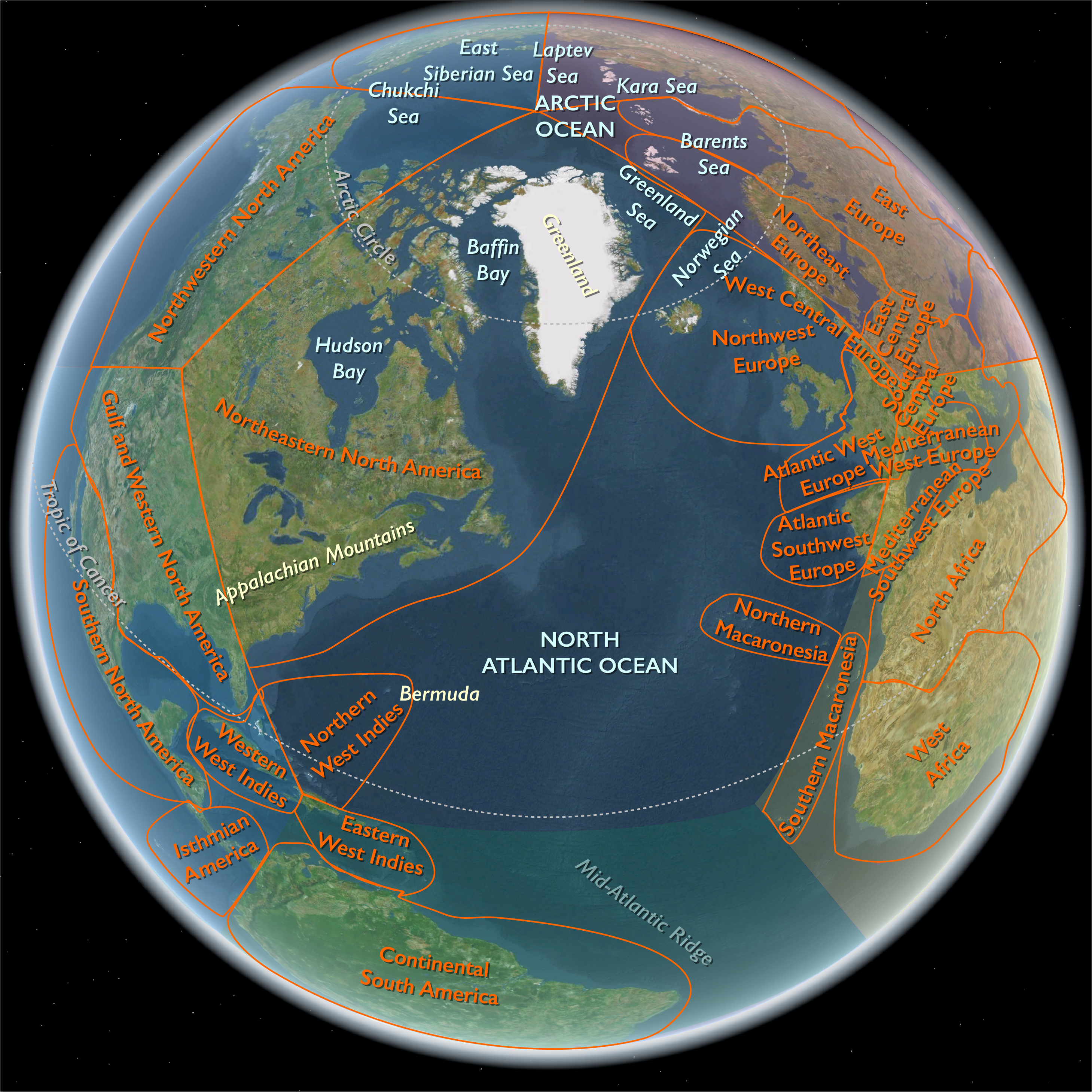
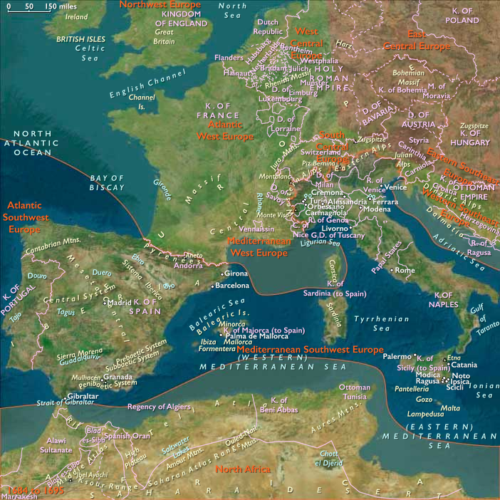
Northeastern North America
(1672 to 1683 CE): Haudenosaunee Ascendancy, French Exploration, and Indigenous Realignments
Between 1672 and 1683 CE, Northeastern North America witnessed a critical decade marked by sustained Haudenosaunee (Iroquois) dominance, significant French colonial exploration into the continental interior, and notable shifts in indigenous alliances and migrations. This period saw intensified European competition, expanding fur-trade networks, and continued indigenous adaptation and resistance amidst demographic and territorial pressures.
French Colonial Expansion and Exploration
Marquette and Jolliet’s Expedition (1673)
In 1673, French-Canadian explorer Louis Jolliet and Jesuit missionary Jacques Marquette undertook a landmark expedition down the Mississippi River, departing from Michilimackinac (the Straits of Mackinac). Traveling by canoe, they became among the first Europeans to document the geography, ecology, and diverse indigenous nations of the Mississippi basin. Their journey significantly enhanced France’s strategic knowledge, establishing claims to the region and foreshadowing future colonization and trade expansion.
La Salle’s Expansive Claims (1679–1682)
Between 1679 and 1682, the French explorer René-Robert Cavelier, Sieur de La Salle built upon Marquette and Jolliet’s earlier discoveries. Launching from the Great Lakes, he explored the Great Lakes region, Illinois Country, and descended the Mississippi to the Gulf of Mexico by 1682, formally claiming the vast watershed for France and naming it Louisiana, after Louis XIV. This dramatically increased French territorial ambitions and reshaped the strategic landscape in North America.
Haudenosaunee Dominance and Consolidation
Sustained Territorial Control
Throughout this era, the Haudenosaunee Confederacy—comprising the Mohawk, Oneida, Onondaga, Cayuga, and Seneca—continued to dominate vast territories stretching from New York to the Great Lakes, northward into Ontario, and southwest into the Ohio and Illinois Valleys. They consolidated control over strategic locations established in the previous decades, including the settlements Ganatsekwyagon (Rouge River) and Teiaiagon (Humber River) near present-day Toronto. These sites served as critical trade and diplomatic hubs, particularly along the strategic Toronto Carrying-Place Trail connecting Lakes Ontario and Huron.
Haudenosaunee Influence on Fur Trade
Haudenosaunee military and diplomatic prowess profoundly shaped the fur-trade landscape. By exerting pressure on neighboring indigenous groups and European colonists, they maintained dominant control over essential trade routes linking interior tribes to European markets, particularly through their crucial relationship with English traders in newly acquired New York (formerly New Netherland, seized by the English in 1664).
Indigenous Displacement, Migration, and Realignment
Shawnee Displacement and Migration
Following their displacement by Haudenosaunee forces around 1660, the Shawnee continued migrating westward and southward during this decade, settling in regions along the southern Appalachians, the Cumberland Plateau, and the lower Ohio and Mississippi Valleys. These movements fundamentally altered indigenous demographic and diplomatic dynamics throughout the central and southern interior.
Iroquoian-speaking Diaspora
Survivors of defeated Iroquoian-speaking nations, including the Huron (Wyandot), Neutral, and Erie, consolidated into new settlements around the western Great Lakes, often aligning with French trade and missionary networks. Their presence reshaped regional politics, economics, and cultural exchanges, laying foundations for later indigenous-French alliances.
Emergence of the Mississauga in Southern Ontario
By the late 1670s, the Algonquian-speaking Mississauga had begun expanding into territories previously dominated by the Haudenosaunee, including the areas around Toronto. This gradual westward movement set the stage for their eventual control of southern Ontario after the Haudenosaunee withdrawal in 1701, marking significant changes in the region’s indigenous dynamics.
European-Indigenous Relations and Conflicts
Growing French-Indigenous Alliances
French alliances strengthened significantly with Algonquian-speaking tribes such as the Ottawa, who by the late seventeenth century became the primary intermediaries in the western Great Lakes fur trade. This relationship secured French economic interests despite ongoing Haudenosaunee threats, stabilizing the French colonial economy and solidifying Ottawa influence.
English Colonial Expansion and Alliance Dynamics
English colonies in New England and New York expanded rapidly, intensifying indigenous territorial pressures. While remaining largely free from direct Haudenosaunee military threats due to their alliance through trade, the English increasingly came into conflict with other indigenous groups, laying the groundwork for major regional conflicts such as King Philip’s War (1675–1676).
King Philip’s War (1675–1676)
In 1675, a major conflict erupted in southern New England known as King Philip’s War. Waged primarily between English colonists and a coalition of indigenous nations led by Metacom (King Philip), a Wampanoag leader, this brutal war devastated the region, resulting in massive casualties on both sides, extensive destruction of indigenous settlements, and the weakening of indigenous power throughout southern New England.
Epidemic Disease and Indigenous Demographic Collapse
Persistent Disease Devastation
During this decade, smallpox, measles, influenza, and other diseases continued to devastate indigenous populations, exacerbating demographic decline and weakening indigenous political structures. Communities already destabilized by warfare became further vulnerable, accelerating European colonial expansion and exacerbating internal indigenous tensions.
Interior Indigenous Stability and Cultural Continuity
Cheyenne and Plains Indigenous Communities
The Cheyenne, occupying territories between the Mississippi River and Mille Lacs Lake (present-day Minnesota), maintained traditional subsistence patterns of bison hunting and wild rice gathering. They increasingly engaged in expanding regional trade networks, demonstrating resilience and strategic adaptation to changing circumstances.
Siouan-speaking Peoples: Territorial Stability and Westward Movements
The Dakota, Assiniboine, and Winnebago (Ho-Chunk) retained relative stability across the upper Midwest, isolated from major colonial encroachment yet strategically engaged in trade. Meanwhile, Siouan-speaking tribes such as the Osage, Omaha, Kansa, Iowa, and Quapaw continued their westward and southern migrations under growing pressures from Haudenosaunee expansion and colonial settlement.
Newfoundland’s Beothuk: Increasing Vulnerability
Intensifying English Encroachment
The indigenous Beothuk continued facing extreme pressure in Newfoundland due to expanding English settlements and resource competition. Increasing isolation and continued disease outbreaks significantly threatened their survival and cultural integrity during this period.
Indigenous Artistic and Cultural Resilience
Continuity of Traditions and Ceremonies
Despite widespread upheaval, indigenous communities maintained vibrant cultural practices, including ceremonial beadwork, pottery, ornate tobacco pipes, and shell gorgets. Ritual traditions—such as Haudenosaunee Longhouse ceremonies, Algonquin seasonal celebrations, and Plains tribal rituals—continued robustly, providing resilience and cultural continuity amidst turbulent changes.
Environmental Adaptations and Resource Management
Little Ice Age and Indigenous Adaptations
The continuing Little Ice Age required indigenous communities to adapt through diversified subsistence strategies, seasonal mobility, and expanded trade networks. These adaptations demonstrated remarkable ecological resilience, enabling communities to mitigate climatic challenges and resource uncertainties.
Legacy of the Era (1672–1683 CE)
The era 1672–1683 CE was pivotal in shaping Northeastern North America’s political, economic, and cultural landscape. French explorations by Marquette, Jolliet, and La Salle significantly expanded colonial claims and ambitions, transforming indigenous and European interactions. Haudenosaunee dominance persisted through strategic military and economic influence, notably in the fur trade, reshaping indigenous demographics through forced migrations of Shawnee, Wyandot, and other groups. The devastating King Philip’s War underscored growing indigenous-colonial tensions, accelerating indigenous territorial loss and reshaping power dynamics in southern New England. Despite profound pressures from epidemics, warfare, and displacement, indigenous resilience remained evident in cultural continuity, adaptive strategies, and strategic realignments, laying the foundations for enduring patterns of indigenous-colonial interactions and shaping future geopolitical developments across Northeastern North America.
The combined population of Quebec and ...
...Montreal numbers over five thousand by 1672.
Since Henry Hudson had in 1610 claimed Hudson Bay and the surrounding lands for England, English colonists have begun expanding their boundaries across what is now the Canadian north beyond the French-held territory of New France.
With the help of French coureurs des bois Pierre-Esprit Radisson and Médard des Groseilliers, the Hudson's Bay Company had been established in 1670 to control the fur trade in all the land that drains into Hudson Bay.
This has ended the French monopoly on the Canadian fur trade.
The French seek to compensate by extending their territory to the south and to the west of the American colonies.
The brigantine Le Griffon, commissioned by French explorer René Robert Cavelier, Sieur de La Salle, is towed from Cayuga Creek, where it had been constructed by La Salle and officer Henri de Tonti over the winter of 1678-79, to the southern end of the Niagara River, to become the first ship to sail the upper Great Lakes.
In his quest to find the Northwest Passage to China and Japan to extend France’s fur trade, La Salle and Father Louis Hennepin set out on the Le Griffon's maiden voyage on August 7, 1679 with a crew of thirty-two, sailing across Lake Erie, Lake Huron and Lake Michigan through uncharted waters that only canoes had previously explored.
At Fort Conti, which they had built at the mouth of the Niagara River and Lake Ontario a few months earlier, they shift supplies and materials brought from Fort Frontenac into smaller boats, canoes or bateaux.
They want to be able to travel up the lower part of the shallow Niagara River, to what is now the location of Lewiston, New York.
The Iroquois have a well-established portage route in the area which they use to avoid the rapids and the cataract later known as Niagara Falls.
La Salle uses Le Griffon to sail up Lake Erie to Lake Huron, then up Huron to Michilimackinac.
La Salle’s party sounds Point St. Ignace on the evening of August 27 and anchors in the calm waters of the natural harbor at Mackinaw Island where there is a settlement of Hurons, Ottawas, and a few Frenchmen.
La Salle found some of the fifteen men he had sent ahead from Fort Frontenac to trade with the Illinois but they had listened to La Salle's enemies, who said he would never reach Mackinac Island.
La Salle seizes two of the deserters and sends Tonti with six men to arrest two more at Sault Ste. Marie.
The short open-water season of the upper Great Lakes had compelled La Salle to depart for Green Bay on September 12, five days before Tonti's return.
They sailed from the Straits of Mackinac to an island (either Washington Island or Rock Island) located at the entrance of Lake Michigan’s Green Bay.
They anchor on the south shore of the island and find it occupied by friendly Potawatomis and fifteen of the fur traders La Salle had sent ahead.
The traders had collected twelve thousand pounds of furs in anticipation of the arrival of the Le Griffon.
La Salle decides to stay behind with four canoes to explore the head of Lake Michigan.
La Salle gives instructions for Le Griffon to off-load merchandise for him at Mackinac Island that would be picked up on the return trip.
Le Griffon rides out a violent storm for four days and then on September 18, the pilot Luc and five crew sail under a favorable wind for the Niagara River with a parting salute from a single gun.
She carries a cargo of furs valued at from fifty thousand to sixty thousand francs ($ten thousand to twelve thousand dollars) and the rigging and anchors for another vessel that La Salle intends to build to find passage to the West Indies.
La Salle will never see Le Griffon again.
Father Hennepin will later write that Le Griffon was lost in a violent storm.
Some charge fur traders, and even Jesuits with her destruction; others aid that the Ottawas or Potawatomis boarded her, murdered her crew, and then burned her.
La Salle was convinced that the pilot and crew treacherously sank her and made off with the goods.
There is no conclusive evidence about any of the theories about Le Griffon's loss.
Le Griffon is reported to be the "Holy Grail" of Great Lakes shipwreck hunters.
A number of sunken old sailing ships have been suggested to be Le Griffon but, except for the ones proven to be other ships, there has been no positive identification.
One candidate is a wreck at the western end of Manitoulin Island in Lake Huron, ...
...with another wreck near Escanaba, Michigan, also proposed.
Le Griffon, the second in a string of thousands of ships that will go to rest on the bottom of the Great Lakes, is mistakenly called the first ship to be lost to the Great Lakes.
The first ship was another built by La Salle, called the Frontenac, a ten-ton single-decked brigantine or barque.
The Frontenac had been lost in Lake Ontario, on January 8, 1679.
Le Griffon may have been found recently by the Great Lakes Exploration Group but the potential remains are the subject of lawsuits involving the discoverers, the state of Michigan, the U.S. federal government and the government of France.
La Salle, having departed with his men in canoes down the western shore of Lake Michigan, arrives at the mouth of the Miami River (now St. Joseph River) in October 1679, where La Salle's men build a stockade they call Fort Miami (now known as St. Joseph, Michigan.)
Here they wait for Tonti and his party, who have crossed the peninsula on foot.