Muhammad Ali of Egypt
Wāli of Egypt, Sudan, Palestine, Syria, Hejaz, Morea, Thasos, Crete
Years: 1769 - 1849
Muhammad Ali Pasha al-Mas'ud ibn Agha (Arabic: Muḥammad ʿAlī Bāšā) (Mehmet Ali Pasha in Albanian; Kavalalı Mehmet Ali Paşa in Turkish) (4 March 1769 – 2 August 1849) is an Albanian commander in the Ottoman army, who becomes Wāli, and self-declared Khedive of Egypt and Sudan.
Though not a modern nationalist, he is regarded as the founder of modern Egypt because of the dramatic reforms in the military, economic and cultural spheres that he institutes.
He also rules Levantine territories outside Egypt.
The dynasty that he establishes will rule Egypt and Sudan until the Egyptian Revolution of 1952.
Related Events
Filter results
Showing 10 events out of 111 total
The Near and Middle East (1684 – 1827 CE)
Empires in Decline, Pilgrimage Routes in Turmoil, and the Return of Reforming Powers
Geography & Environmental Context
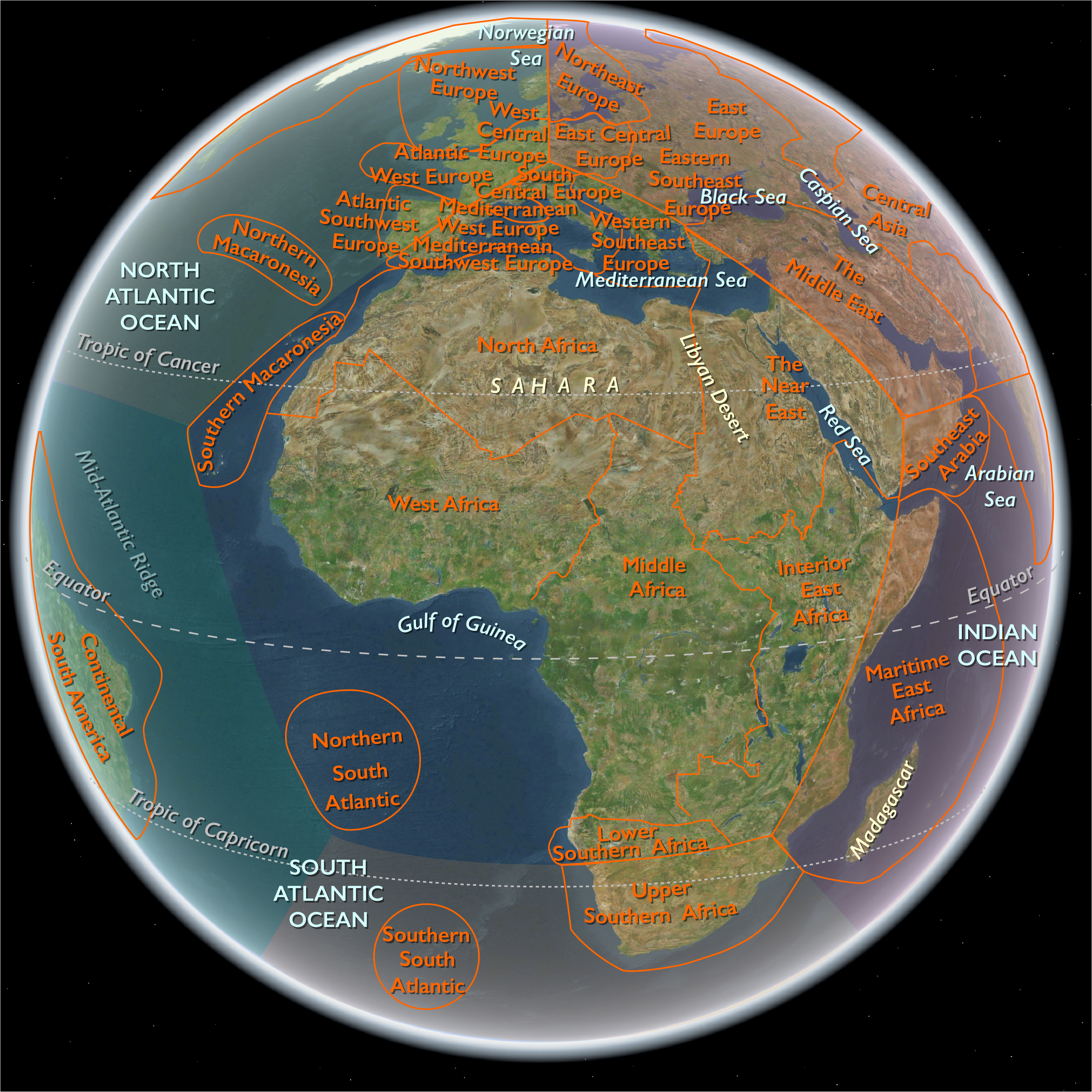
The Near and Middle East spanned the eastern Mediterranean, the Arabian Peninsula, Mesopotamia, Persia, and the Caucasus—a crossroads from the Nile to the Hindu Kush. Its three interlocking subregions—the Near East(Egypt, Hejaz, Yemen, Levant, Sudan, southwestern Turkey, and Cyprus), the Middle East (Iraq, Iran, Syria, Armenia, Georgia, Azerbaijan, eastern Arabia, and most of Anatolia), and Southeast Arabia (southern Oman, eastern Yemen, and Socotra)—together formed a vast zone of deserts, deltas, plateaus, and pilgrimage corridors. Major anchors included the Nile, Tigris–Euphrates, and Zagros–Caucasus uplands; the Red Sea, Persian Gulf, and Arabian Seacoasts; and the high valleys of Yemen and Oman that bridged Africa and Asia.
Climate & Environmental Shifts
The late Little Ice Age imposed alternating drought and flood.
-
Mesopotamia and Iran endured erratic rains and destructive river floods.
-
Egypt oscillated between low- and high-Nile years; plague and famine shadowed poor floods.
-
Hejaz and Yemen suffered water scarcity punctuated by torrential storms.
-
Caucasus winters grew harsher; earthquakes at Tabriz (1721), Shiraz (1824), and along the Levantine Riftreshaped towns.
-
Dhofar and Hadhramawt relied on fickle khareef monsoons, while Socotra was struck by periodic cyclones.
Despite volatility, canal maintenance, terrace farming, and nomadic mobility preserved regional resilience.
Subsistence & Settlement
-
Mesopotamia & Iran: Irrigated grains, dates, and silk; qanats and canals remained vital to subsistence and taxation.
-
Caucasus & Anatolia: Pastoralism and mountain farming—wine, fruit, and grain—supported caravan towns like Tiflis, Yerevan, and Aleppo.
-
Levant & Egypt: Terrace agriculture (olives, vines, citrus) complemented Nile wheat, barley, and sugar.
-
Arabian littoral: Date groves, pearling, and fishing from Basra to Muscat linked desert to sea.
-
Yemen & Oman: Terraced grains, coffee, and frankincense; mixed herding in uplands.
-
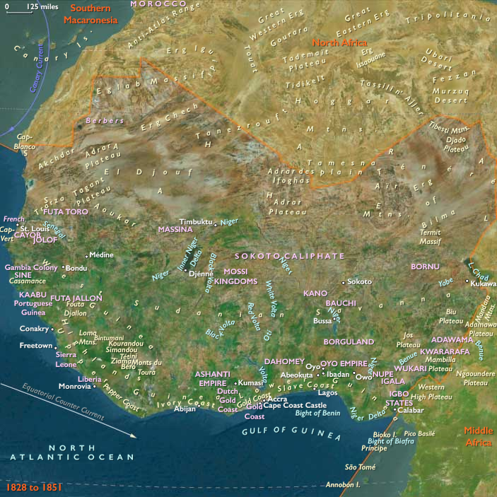
Sudan: Millet and sorghum in river belts tied to Egypt’s provisioning system after Muḥammad ʿAlī’s conquest (1820–1821).
Urban centers—Cairo, Baghdad, Isfahan, Damascus, Tehran, Muscat, Sanaʿa, and Tiflis—functioned as nodes of governance, trade, and craft.
Technology & Material Culture
-
Agrarian infrastructure: Qanats, canals, and dikes remained the hydraulic spine; terrace systems in Yemen and Palestine embodied millennia of continuity.
-
Crafts & manufactures: Persian silks and carpets; Aleppine cottons; Damascene soap; Cairene brassware; Georgian and Armenian metallurgy.
-
Architecture: Ottoman domes, Safavid and Qajar mosques, Armenian churches, and Yemeni tower-houses defined skylines.
-
Maritime innovation: Omani dhows and Red Sea sambuks maintained oceanic trade; firearms and artillery modernized gradually through Ottoman and Persian reforms.
-
Printing & learning: The French expedition to Egypt (1798–1801) introduced presses and surveying; by the 1820s Muḥammad ʿAlī’s workshops were producing cotton gins, arms, and canal plans.
Movement & Interaction Corridors
-
Caravan arteries: Aleppo–Mosul–Baghdad; Isfahan–Tabriz–Yerevan–Baku; Basra–Shiraz–Hormuz–Muscat.
-
Pilgrimage routes: Cairo and Damascus caravans converged on Mecca until disrupted by Wahhabi–Saʿūdī control (1803–1812); Egyptian forces restored Ottoman sovereignty (1811–1818).
-
Maritime spheres: Omani fleets projected power across the Indian Ocean to Zanzibar; Hadhrami merchants spread to Gujarat, Southeast Asia, and the Swahili coast.
-
Caspian & Black Sea fronts: Russian expansion brought forts and commerce, drawing Persia into treaties (Gulistan 1813, Turkmenchay 1828).
-
Nile & Sudan corridors: River convoys moved grain and troops; Khartoum and Sennar became extensions of Cairo’s fiscal reach.
Cultural & Symbolic Expressions
-
Ottoman provinces: Sunni institutions, Sufi lodges, and urban guilds organized civic life; Coptic, Armenian, Greek, and Jewish communities sustained schools and trade.
-
Persia: Shiʿism remained the ideological core from Safavid through Qajar eras; Isfahan and Tehran mosques, gardens, and miniatures embodied Persian identity.
-
Caucasus: Islamic and Christian traditions coexisted; oral epics preserved frontier memory.
-
Arabian coasts: Poetry, pearling songs, and mosque schools reflected maritime Islam.
-
Hejaz & Yemen: Pilgrimage festivals, Sufi orders, and coffee rituals intertwined devotion and commerce.
-
Egypt: Al-Azhar scholars debated governance; after 1798, the Arabic press and translation offices of Muḥammad ʿAlī inaugurated modern intellectual life.
Environmental Adaptation & Resilience
-
Nomadic transhumance adjusted to drought belts from Arabia to Iran.
-
Oasis and terrace restoration maintained food security.
-
Maritime adaptation: Oman’s sea routes and Gulf pearling offset inland disruption.
-
Pilgrim provisioning: Waqf-funded cisterns, markets, and bakeries sustained caravans.
-
Irrigation renewal: In Egypt, canal repair and proto-barrage planning sought to stabilize Nile floods and expand cotton cultivation.
Political & Military Shocks
-
Safavid collapse (1722): Afghan incursions toppled Isfahan; Ottoman and Russian invasions followed.
-
Nader Shah (1736–1747): Restored Persian power, campaigned in India and the Caucasus.
-
Qajar consolidation (1794–1827): Centralized Iran but ceded territory to Russia.
-
Ottoman strain: Frontier wars with Russia; Wahhabi revolt in Arabia; provincial autonomy in Syria and Egypt.
-
Muḥammad ʿAlī’s rise (1805): Eliminated Mamluks (1811), reformed army and monopolies, annexed Sudan (1820–1821).
-
Omani revival: The Al Bu Saʿid dynasty (from 1749) rebuilt fleets, expelled Portuguese remnants, and dominated Gulf trade.
-
European encroachment: Consuls, treaties, and naval patrols—French in the Levant, British in the Gulf and Red Sea—tightened economic dependence though not yet direct rule.
Transition
Between 1684 and 1827 CE, the Near and Middle East transformed from a network of venerable Islamic empires into a patchwork of reforming provinces and maritime powers under growing Eurasian pressure. The Safavids vanished, the Qajars struggled with Russia, and the Ottomans faced internal revolt and European diplomacy. Oman extended Arab reach to East Africa, while Muḥammad ʿAlī’s Egypt pioneered modern bureaucratic reform.
By 1827, caravan and monsoon still ordered daily life, yet behind their continuity loomed the industrial powers of Europe—ready to recast these crossroads into the geopolitical heart of the nineteenth-century world.
The Middle East (1684–1827 CE): Ottoman Decline, Safavid Collapse, and the Rise of New Powers
Geography & Environmental Context
The Middle East includes Iraq, Iran, Syria, Armenia, Georgia, Azerbaijan, Qatar, Bahrain, the United Arab Emirates, most of Turkey (except the European part and southwest Anatolia), eastern Jordan, all but southernmost Lebanon, eastern Saudi Arabia, and northern Oman. Anchors include the Tigris–Euphrates basin (Mesopotamia), the Zagros and Caucasus ranges, the Iranian Plateau, the Caspian littoral, the Syrian Desert, and the Persian Gulf and Caspian Sea coasts. This geography spans irrigated river valleys, steppe corridors, semi-arid plateaus, and mountain enclaves linking Anatolia, Persia, and Arabia.
Climate & Environmental Shifts
The period fell within the late Little Ice Age, producing cooler winters in Anatolia, Armenia, and the Caucasus, alongside recurrent droughts in Mesopotamia and Iran. Floods along the Tigris and Euphrates periodically devastated farmlands, while earthquakes struck Tabriz (1721) and Shiraz (1824). Pastoral nomads in Arabia, Iran, and the Caucasus moved widely to buffer drought, while irrigation in Mesopotamia and northern Iran faltered under war and neglect but revived when political stability returned.
Subsistence & Settlement
-
Mesopotamia: Date groves, rice paddies, and cereal fields along the Tigris–Euphrates remained staples; tribal confederations dominated countryside around Ottoman Baghdad.
-
Iranian Plateau: Dryland farming (wheat, barley) and oasis gardening (fruit, melons) sustained populations; silk in Gilan and rice in Mazandaran anchored Caspian subsistence.
-
Caucasus (Armenia, Georgia, Azerbaijan): Pastoralism, viticulture, and orchards flourished in upland valleys; caravan towns like Tiflis and Yerevan mediated exchange.
-
Anatolia & Syria: Grain, olives, and vines in uplands; Aleppo and Damascus remained provisioning and craft centers despite periodic crises.
-
Persian Gulf & Oman: Fishing, date cultivation, and pearling dominated, with maritime trade sustaining settlements from Basra to Muscat.
Technology & Material Culture
Agriculture relied on qanats, canals, and animal-powered irrigation. Fortresses and caravanserais dotted plateau routes; mosques, madrasas, and Armenian and Georgian churches anchored towns. Persian silk textiles, Azerbaijani carpets, and Aleppine cottons were prized. Gunpowder weapons, artillery, and fortress improvements spread, though unevenly. Maritime craft ranged from Ottoman galleys to Omani dhows controlling Indian Ocean lanes.
Movement & Interaction Corridors
-
Caravan routes: Linked Aleppo to Mosul and Baghdad; Isfahan to Tabriz, Yerevan, and Baku; Basra to the Gulf; Shiraz and Yazd to Hormuz/Muscat.
-
Persian Gulf: Omani seafaring extended across the Arabian Sea; Basra exported dates and grain; pearl fisheries tied Bahrain and Qatar to Indian and European markets.
-
Caspian trade: Connected Gilan’s silk and Astrakhan’s markets; Russian expansion brought new garrisons and merchants.
-
Imperial contest zones: Anatolia and the Caucasus saw repeated wars; Iraq oscillated between Ottoman and Persian control.
Cultural & Symbolic Expressions
-
Ottoman provinces: Islam anchored society through mosques, Sufi lodges, and guilds; Armenian and Syriac Christians maintained schools and churches; Jewish communities thrived in Aleppo and Baghdad.
-
Safavid Iran: Shi‘ism remained state religion; Isfahan’s mosques and gardens expressed grandeur, though after the Safavid collapse, Qajar art and architecture reshaped Persian identity.
-
Caucasus: Christian Orthodoxy (Georgian, Armenian) coexisted with Islam; mountain oral epics and shrine pilgrimages preserved memory.
-
Arabian littoral: Tribal poetry, pearl-diver songs, and Omani mosque schools expressed maritime identity.
Environmental Adaptation & Resilience
-
Nomadic strategies: Tribal migrations across steppe and desert balanced drought and grazing.
-
Oasis and qanat systems: Managed water for cereals and orchards; local repair after war was critical.
-
Silk, carpet, and date economies: Offered export resilience when crops failed.
-
Maritime trade: Oman and Gulf ports buffered against inland disruption by maintaining Indian Ocean routes.
Transition
Between 1684 and 1827, the Middle East was a contested imperial borderland. The Safavid dynasty collapsed (1722); Afghans, Ottomans, and Russians fought over Iran and the Caucasus. Nader Shah briefly restored Persian power (1736–1747), raiding into India and the Caucasus. The Qajar dynasty (from 1794) consolidated Iran but conceded land to Russia in treaties (Gulistan 1813, Turkmenchay 1828). The Ottoman Empire faced Russian expansion in the Black Sea and Caucasus and Wahhabi revolts in Arabia. Oman emerged as a naval power, dominating the Gulf and East Africa. By 1827, the region was still a mosaic of caravans, mosques, and fortified towns, but the balance of power had tilted toward European and Russian pressures—foreshadowing the 19th-century age of colonial rivalry and reform.
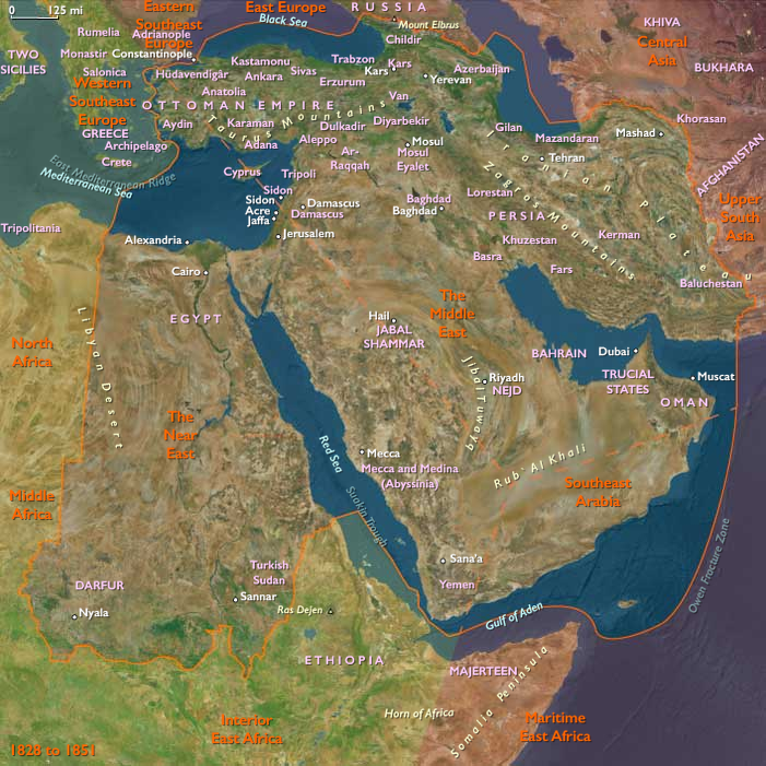
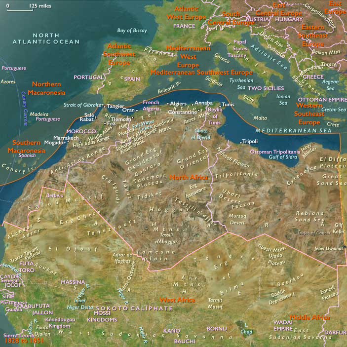
The Near East (1684–1827 CE): Provincial Revolts, Pilgrimage Wars, and the Birth of Reform
Geography & Environmental Context
The Near East comprises Israel, Egypt, Sudan, western Saudi Arabia (the Hejaz), most of Jordan, southwestern Cyprus, southwestern Turkey, and—per our fixed scope—Yemen. Anchors include the Nile Valley and Delta, the Eastern Desert and Sinai, the Levantine coast (Gaza–Acre), the Jordan Valley/Dead Sea, the Hejaz Mountains with Mecca and Medina, southwestern Anatolia (Adana–Antalya arcs), southwestern Cyprus, and the Tihāmah–Yemeni highlands from Mocha to Sanaʽa. River corridors, oases, and pilgrimage routes bound these deserts and littorals to each other and to the wider Ottoman world.
Climate & Environmental Shifts
The waning Little Ice Age brought cooler winters and variable floods. In Egypt, low Nile years meant dearth and plague spikes; high floods burst dikes and washed fields. Hejaz and Jordan suffered drought pulses that stressed caravan wells. Yemen’s monsoon-dependent terraces endured irregular rains, while Red Sea coasts faced periodic storms. Earthquakes rattled Cyprus, the Levant, and Anatolia, disrupting urban fabric and ports.
Subsistence & Settlement
-
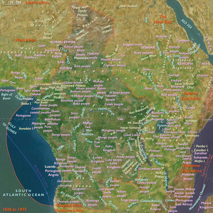
Egypt & Sudan: Nile grains (wheat, barley), flax, sugar, and garden crops sustained Cairo and Alexandria; in Sudan, millet–sorghum belts, date groves, and pastoral corridors linked Sennar and Nubian river towns. After 1820–1821, Muḥammad ʿAlī’s forces conquered Nubia–Sennar, integrating the Blue/White Nile into Egypt’s provisioning sphere.
-
Levant & Cyprus: Olives, vines, citrus, and wheat on terraces and plains; port towns (Acre, Jaffa, Larnaca) shipped oil, soap, and grain.
-
Hejaz: Oases (Taʾif, Yanbuʿ, Jidda) supplied pilgrims with dates, wheat, and livestock; urban Meccan economies revolved around hospitality and ritual markets.
-
Yemen: Terraced grain in the highlands; the coffee complex around Mocha peaked, then faced competition from new global plantings late in the period.
-
Southwestern Anatolia: Mixed cereals, cotton patches, and pastoralism around Adana and the Antalya littoral tied uplands to Mediterranean export lanes.
Technology & Material Culture
Irrigation canals, dikes, and water wheels (sāqiya) maximized Nile yields; stone terrace walls conserved Yemeni and Levantine hillsides. Caravanserais and cisterns dotted hajj and trade routes. Urban crafts flourished: Cairene textiles and brassware; Damascene and Gazan soap; Cypriot silks; Yemeni metalwork and coffee ware. After 1798, the French Expedition introduced printing, surveying, and military workshops in Egypt; by the 1820s, Muḥammad ʿAlī pushed ginning presses and irrigation works that foreshadowed the cotton boom.
Movement & Interaction Corridors
-
Pilgrimage highways: Annual hajj caravans from Cairo, Damascus, and Anatolia converged on Mecca. Warfare with the Wahhabi–Saʿūdī alliance (c. 1803–1812) disrupted these routes until Egyptian campaigns (1811–1818) under Tūsūn and Ibrāhīm Pasha restored the Hejaz to Ottoman control.
-
Red Sea–Indian Ocean: Suez–Jidda–Mocha trunk linked Egypt and Hejaz to Yemen, India, and East Africa; Mocha coffee and Jidda pilgrimage trade knit together merchants from the Maghreb to Gujarat.
-
Levantine–Mediterranean ports: Acre, Jaffa, Alexandria, Antalya, Larnaca funneled oil, grain, and cotton to European shippers; French and British consuls multiplied after 1750.
-
Nile & Sudanese corridors: River convoys carried grain and troops; post-1821 Egyptian garrisons tied Khartoum/Sennar to Cairo’s revenue system.
Cultural & Symbolic Expressions
Sunni Ottoman frameworks dominated, but pluralism remained deep: Coptic Egypt; Greek Orthodox and Armeniancommunities in Levantine ports; Jewish quarters from Cairo to Safed; Zaydi imamate culture in Yemen. The hajj was the region’s supreme ritual artery, sustained by waqf endowments and market networks; scholars, Sufi lineages, and artisans circulated with caravans. In Egypt, chronicles and mosque-university life (al-Azhar) debated governance as Mamluk beys contested Ottoman governors; after 1798, the new Arabic press and translation bureaus under Muḥammad ʿAlī seeded a reformist literary public.
Environmental Adaptation & Resilience
Granary provisioning and price controls in Egypt buffered low Nile years; terrace maintenance in Palestine, Cyprus, and Yemen conserved soil and water. Pilgrims and caravaneers relied on zakat-funded wells, cisterns, and rationing. Pastoral groups in Sudan and the Hejaz shifted herds along rain and pasture gradients. After 1811–1818, restored Hejazi security revived water/food provisioning for pilgrims; in Egypt the expansion of controllable irrigation (canals, barrages-in-planning) aimed to tame flood variability and expand cash crops.
Political & Military Shocks
-
Mamluk–Ottoman duopoly in Egypt: Factional warfare and tax farming culminated in the French occupation (1798–1801); British–Ottoman forces expelled the French.
-
Rise of Muḥammad ʿAlī (1805): Centralization, army reform, and monopolies; massacre of the Mamluks (1811); Hejazi campaigns (1811–1818) crushed the first Saudi state; Sudan conquest (1820–1821) extended Egyptian revenue and slave-soldier recruitment.
-
Levantine strongmen: Aḥmad Pasha al-Jazzār in Acre (late 18th c.) exemplified semi-autonomous Ottoman provincial power.
-
Yemen: Zaydi imams held the highlands; Mocha’s fortunes fluctuated with global coffee competition and Red Sea politics.
-
European pressure: Consular networks, naval visits, and commercial treaties deepened dependence on Mediterranean markets without formal colonization—yet.
Transition
Between 1684 and 1827, the Near East shifted from a stable Ottoman heartland—sustained by pilgrimage, terraces, and Nile irrigation—to a laboratory of coercive reform and imperial entanglement. Hajj wars and Egyptian campaigns bound the Hejaz back to Istanbul; French invasion jolted Egypt into an era of state-driven modernization; Sudan’s incorporation widened Cairo’s reach; Yemen’s coffee pole waned as global rivals rose. By 1827, caravans and canals still ordered life—yet Muḥammad ʿAlī’s armies, monopolies, and irrigation works signaled a new dispensation in which provincial power, not distant sultans, would set the rhythm of Near Eastern change.
The Egyptian occupation of Sudan is initially disastrous.
Under the new government established in 1821, which is known as the Turkiyah or Turkish regime, soldiers live off the land and exact exorbitant taxes from the population.
They also destroy many ancient Meroitic pyramids searching for hidden gold.
Furthermore, slave trading increases, causing many of the inhabitants of the fertile Al Jazirah, heartland of Funj, to flee to escape the slave traders.
Thirty thousand enslaved Sudanese men go to Egypt for training and induction into the army within a year of the pasha's victory.
So many perish from disease and the unfamiliar climate, however, that the remaining enslaved Sudanese can be used only in garrisons in Sudan.
Egypt, as a pashalik of the Ottoman Empire, is divided into several provinces, each of which is placed under a Mamluk bey (governor) responsible to the pasha, who in turn answers to the Porte, the term used for the Ottoman government referring to the Sublime Porte, or high gate, of the grand vizier's building.
No fewer than one hundred pashas will succeed each other in approximately two hundred years years of Ottoman rule
Their authority become tenuous in the eighteenth century as rival Mamluk beys become the real power in the land.
The struggles among the beys continue until 1798 when the French invasion of Egypt alters the situation.
Combined British and Turkish military operations force the withdrawal of French forces in 1801, introducing a period of chaos in Egypt.
The Ottomans seek to restore order in 1805 by appointing Muhammad Ali as Egypt's pasha.
With the help of ten thousand Albanian troops provided by the Ottomans, Muhammad Ali purges Egypt of the Mamluks.
He launches a seven-year campaign in Arabia in 1811, supporting his suzerain, the Ottoman sultan, in the suppression of a revolt by the Wahhabi, an ultraconservative Muslim sect.
To replace the Albanian soldiers, Muhammad Ali plans to build an Egyptian army with enslaved Sudanese recruits.
Although a part of present-day northern Sudan is nominally an Egyptian dependency, the previous pashas had demanded little more from the kashif who rules here than the regular remittance of tribute; this changes under Muhammad Ali.
A party of the Mamluks, after he defeats them in Egypt, escapes and flees south.
These Mamluks establish a state at Dongola in 1811 as a base for their slave trading.
He finally has sixty-four Mamluks, including twenty-four beys, assassinated in the citadel
in March 1811.
From this point forward, Muhammad Ali is the sole ruler of Egypt.
Muhammad Ali represents the successful continuation of policies begun by the Mamluk Ali Bey al Kabir.
Like Ali Bey, Muhammad Ali has great ambitions.
He, too, wants to detach Egypt from the Ottoman Empire, and he realizes that to do so Egypt has to be strong economically and militarily.
The urban notables and the ulama believe that Muhammad Ali is the only leader capable of bringing order and security to the country.
The Ottoman government, however, aware of the threat Muhammad Ali represents to the central authority, attempts to get rid of him by making him governor of the Hijaz.
Eventually, the Ottomans capitulate to Egyptian pressure, and in June 1805, they appoint Muhammad Ali governor of Egypt.
The Egyptian government of Sudan becomes less harsh as the military occupation becomes more secure.
Egypt has saddled Sudan with a parasitic bureaucracy, however, and expects the country to be self-supporting.
Nevertheless, farmers and herders gradually return to Al Jazirah.
The Turkiyah also win the allegiance of some tribal and religious leaders by granting them a tax exemption.
Egyptian soldiers and Sudanese jahidiyah (slave soldiers; literally, fighters), supplemented by mercenaries recruited in various Ottoman domains, man garrisons in Khartoum, Kassala, Al Ubayyid, and at several smaller outposts.
The Shaiqiyah, Arabic speakers who had resisted Egyptian occupation, are defeated and allowed to serve the Egyptian rulers as tax collectors and irregular cavalry under their own sheikhs.
The Egyptians divide Sudan into provinces, which they then subdivide into smaller administrative units that usually correspond to tribal territories.
The Ottoman government is determined to prevent a revival of Mamluk power and autonomy and to bring Egypt under the control of the central government.
The Ottomans appoint Husrev Pasha as viceroy.
Hostilities occasionally break out between his forces and those of the Mamluks who have established themselves in Upper Egypt.
It is apparent by 1803 that a third party has emerged in the struggle for power in Egypt.
This is the Albanian contingent of Ottoman forces that had come in 1801 to fight against the French.
Muhammad Ali, who had arrived in Egypt as a junior commander in the Albanian forces, has by 1803 risen to commander.
He will become he Ottoman viceroy in Egypt in just two short years.
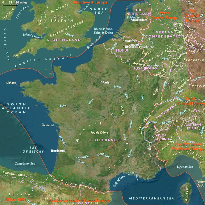
Meanwhile, the Ottoman Sultan negotiates with Muhammad Ali of Egypt, who agrees to send his son Ibrahim Pasha to Greece with an army to suppress the revolt in return for territorial gain.
Ibrahim lands in the Peloponnese in February 1825 and has immediate success: by the end of 1825, most of the Peloponnese is under Egyptian control, and the city of Missolonghi—put under siege by the Turks since April 1825—falls in April 1826.
Although Ibrahim is defeated in Mani, he has succeeded in suppressing most of the revolt in the Peloponnese and Athens has been retaken.