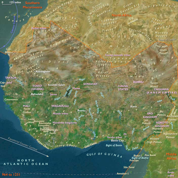
West Africa (964 – 1107 CE): Ghana’s …
Years: 964 - 1107
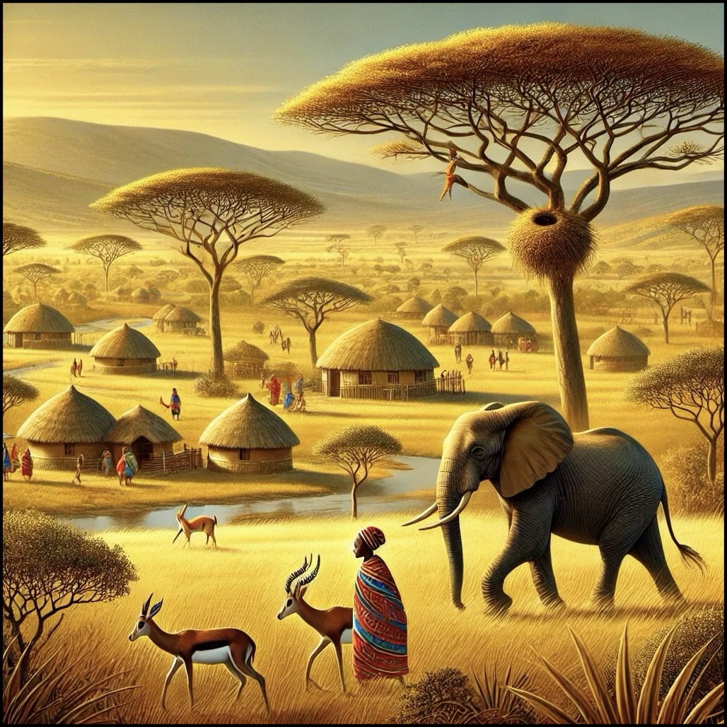
West Africa (964 – 1107 CE): Ghana’s Zenith, Sahelian Towns, and Forest Gateways
Geographic and Environmental Context
West Africa includes Senegal, Mauritania, Mali, Burkina Faso, Niger, Guinea, Sierra Leone, Liberia, Côte d’Ivoire, Ghana, Togo, Benin, and Nigeria (western and central).
-
The Sahelian belt (Senegal–Niger valleys) anchored kingdoms like Ghana (Wagadu) and Takrur.
-
The Niger Bend and inner Niger delta supported riverine farming, fishing, and trade, with towns such as Gao rising to prominence.
-
The forest–savanna frontiers of modern Guinea, Côte d’Ivoire, and Ghana served as entry points for gold, kola, and ivory into Sahelian networks.
-
In the east, Hausaland (northern Nigeria) consolidated into a mosaic of town-based polities linked to desert and savanna routes.
Climate and Environmental Shifts
-
The Medieval Warm Period (c. 950–1250) brought more stable rainfall to the Sahel, supporting millet, sorghum, and livestock across wide zones.
-
Flood-recession agriculture in the inner Niger delta flourished, producing cereals, vegetables, and fish surpluses.
-
Periodic dry years still occurred, but ecological diversity across Sahel, savanna, and forest buffered subsistence.
Societies and Political Developments
-
Ghana (Wagadu):
-
Reached its peak by the late 10th–11th centuries, ruling from Koumbi Saleh, with dual cities for indigenous and Muslim merchant populations.
-
Controlled the Awdaghust–Sijilmāsa caravan axis, extracting tribute and tolls on gold, salt, copper, and slaves.
-
Kings of Ghana patronized indigenous rituals but hosted Muslim scholars and traders, balancing dual authority.
-
-
Takrur (Senegal valley):
-
Consolidated as a kingdom rivaling Ghana; rulers adopted Islam earlier than Ghana’s kings, fostering closer ties with North African merchants.
-
-
Gao (Songhay ancestors):
-
Emerged as a rival Sahelian power on the eastern Niger; by the 11th century, Gao was a recognized kingdom with a Muslim ruling elite, noted in Arabic sources.
-
-
Forest–savanna margins:
-
Mande-speaking traders and Akan ancestors channeled gold (Bambuk, Bure), kola nuts, and ivory northward.
-
Lineages in Upper Guinea and the Gold Coast consolidated towns, creating durable supply networks.
-
-
Hausaland:
-
Urban communities at Kano, Katsina, Zaria grew into organized towns, each with ruling dynasties and fortified walls.
-
Early Hausa polities integrated farming, craft, and caravan trade.
-
-
Benin region:
-
Edo-speaking communities clustered around chiefs; early forms of the Benin polity emerged in the 11th century.
-
Economy and Trade
-
Gold–salt trade: Ghana mediated the movement of gold from Bambuk/Buré to Sijilmāsa and beyond, while Saharan salt moved south.
-
Copper and iron: copper from Takedda and Air supplied smiths; local ironworking thrived in savanna belts.
-
Agriculture: millet and sorghum in Sahel; African rice in Upper Guinea; yams and oil palm in forest margins.
-
Livestock: cattle, sheep, and goats grazed in the Sahel; horses (imported from the Maghreb) became symbols of elite power.
-
Slaves: captured in frontier wars, traded north across the Sahara, and incorporated into Sahelian households.
-
Craft production: raffia cloth, iron tools, wooden sculptures, and leatherwork enriched markets.
Subsistence and Technology
-
Farming systems: intensive irrigation and flood-recession farming in Senegal and Niger valleys.
-
Pastoralism: transhumant cycles linked Sahel pastures with riverside gardens.
-
Iron technology: bloomery furnaces supplied hoes, axes, spearheads, and ornaments.
-
River transport: dugout canoes on the Senegal, Gambia, and Niger moved goods and people.
-
Caravan technology: camels carried gold, salt, ivory, and textiles across the Sahara in organized trains.
Movement and Interaction Corridors
-
Awdaghust ⇄ Sijilmāsa ⇄ Koumbi Saleh: Ghana’s critical trans-Saharan axis.
-
Niger Bend ⇄ Gao ⇄ Air: eastern routes carrying copper, salt, and slaves.
-
Senegal River ⇄ Takrur ⇄ Atlantic littoral: opening Sahelian trade toward the ocean, centuries before European contact.
-
Forest tracks ⇄ Sahel towns: Mande and Akan traders linked forest resources to Sahel markets.
-
Hausaland ⇄ Air ⇄ Sahara: Hausa towns connected to Saharan gateways for copper and textiles.
Belief and Symbolism
-
Indigenous religions: earth shrines, ancestral spirits, and sacred groves legitimized land and kingship.
-
Islam:
-
Spread among merchants, scholars, and some rulers (notably Takrur and Gao).
-
Muslim quarters in Ghana’s Koumbi Saleh flourished, while Ghana’s kings retained indigenous rituals.
-
-
Symbolic economy: horses, gold ornaments, and elaborate burials marked elite power.
-
Festivals synchronized agricultural and trading calendars, reinforcing community bonds.
Adaptation and Resilience
-
Ecological complementarity: gold from forests, grain from Sahel, salt from Sahara ensured resilience.
-
Political dualism: rulers balanced indigenous ritual authority with Muslim merchant literacy and diplomacy.
-
Caravan redundancy: shifting routes ensured continuity even when climate or politics disrupted one path.
-
Lineage networks: in forest and savanna, kin-based alliances stabilized trade and subsistence.
Long-Term Significance
By 1107 CE, West Africa stood at a high point of Sahelian power and trans-Saharan integration:
-
Ghana (Wagadu) controlled the gold–salt axis at its zenith.
-
Takrur rose in the Senegal valley as an Islamic kingdom.
-
Gao emerged as a Muslim-led Sahelian power.
-
Forest frontiers provided gold, kola, and ivory through Mande traders.
-
Hausaland and Benin laid the foundations of durable polities.
This era established West Africa as a pivot of Afro-Eurasian trade, blending indigenous traditions with the growing influence of Islam, and setting the stage for the decline of Ghana and the rise of Mali in the 13th century.
West Africa (with civilization) ©2024-25 Electric Prism, Inc. All rights reserved.
Groups
- Hausa Kingdoms, the
- Hausa people
- Islam
- Soninke people
- Sijilmassa, Berber state of
- Ghana (Wagadou) Empire
- Takrur, state of
- Yoruba people
- Kano (Hausa city state)
- Katsina (Hausa city state)
- Zaria (Zazzau), Hausa City-State of
- Mossi people
- Mossi Kingdoms
Topics
Commodoties
- Fish and game
- Weapons
- Gem materials
- Domestic animals
- Grains and produce
- Textiles
- Ceramics
- Strategic metals
- Slaves
- Salt
- Manufactured goods
Subjects
Regions
Subregions

Related Events
Showing 10 events out of 52798 total
Years: 964 - 1107
West Africa (with civilization) ©2024-25 Electric Prism, Inc. All rights reserved.
Groups
- Hausa Kingdoms, the
- Hausa people
- Islam
- Soninke people
- Sijilmassa, Berber state of
- Ghana (Wagadou) Empire
- Takrur, state of
- Yoruba people
- Kano (Hausa city state)
- Katsina (Hausa city state)
- Zaria (Zazzau), Hausa City-State of
- Mossi people
- Mossi Kingdoms
Topics
Commodoties
- Fish and game
- Weapons
- Gem materials
- Domestic animals
- Grains and produce
- Textiles
- Ceramics
- Strategic metals
- Slaves
- Salt
- Manufactured goods
Subjects
Regions
Subregions