Thomas Cole hikes west high up into …
Years: 1825 - 1825
November
He had taken a steamship up the Hudson in the autumn of 1825, the same year the Erie Canal opened, stopping first at West Point, then at Catskill landing.
The first review of his work appears in the New York Evening Post on November 22, 1825.
At this time, only the English native Cole, born in a landscape where autumnal tints were of browns and yellows, finds the brilliant autumn hues of the area to be inspirational.
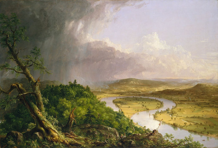
Related Events
Filter results
Showing 10 events out of 27 total
Northeastern North America (1828–1971 CE)
Industrial Heartlands, Atlantic Gateways, and Cold War Crossroads
Geography & Environmental Context
Northeastern North America includes all territory east of 110°W, except the lands belonging to Gulf and Western North America. This encompasses the Great Lakes basin, the St. Lawrence River corridor, Hudson Bay and Labrador, Newfoundland, Greenland, the Arctic, the Maritime provinces, and the Atlantic seaboard from New England through Virginia, the Carolinas, and most of Georgia. It also contains the Mississippi Valley north of Illinois’ Little Egypt and the Upper Missouri above the Iowa–Nebraska crossing, as well as northeast Alabama, central and eastern Tennessee, and nearly all of Kentucky.
Anchors included the Great Lakes–St. Lawrence corridor, the Appalachian piedmont, Hudson Bay, the Greenland ice sheet, and the Atlantic coastal plain. This was a region of forests and prairies, industrializing river valleys, and Arctic margins increasingly integrated into continental and global networks.
Climate & Environmental Shifts
The 19th century saw the close of the Little Ice Age, with harsh winters persisting into the mid-century before gradual warming by the 20th. The Great Lakes and St. Lawrence valleys endured blizzards and drought cycles. Greenland’s sea ice remained extensive until the early 20th century, then retreated. Atlantic storms reshaped seaboards, while the Dust Bowl’s fringes touched the upper Mississippi Valley. By the mid-20th century, industrial pollution, damming, and deforestation altered rivers and lakes. Warmer conditions opened some Arctic navigation and enabled agricultural expansion on the prairies.
Subsistence & Settlement
-
United States:
-
The eastern seaboard and interior transformed into an industrial core. Wheat, corn, and cotton farming underpinned rural life, while cities like New York, Boston, Philadelphia, Cleveland, Detroit, and Chicago grew as manufacturing giants.
-
Immigration from Europe swelled urban populations; African Americans migrated north in the Great Migration, reshaping cities.
-
-
Canada:
-
Confederation (1867) bound Ontario, Quebec, and the Maritimes; later provinces joined as prairie farming expanded through the Great Lakes–St. Lawrence corridor.
-
Industrial centers like Montreal, Toronto, and Halifax grew rapidly.
-
-
Greenland:
-
Inuit sustained hunting and fishing lifeways; Danish colonial administrators introduced trade posts, missions, and modernization projects.
-
Sealing and cod fisheries dominated, while U.S. bases after WWII tied Greenland into Cold War strategy.
-
-
Indigenous nations: Though often displaced or confined, Native communities persisted through fur trade, wage labor, and mixed economies, maintaining ceremonies and oral traditions despite assimilationist pressures.
Technology & Material Culture
-
Industrialization: Steamships, canals (Erie, Welland), and railroads structured 19th-century movement. Iron, coal, and later oil fueled factories; by the 20th century, automobiles, telephones, and electricity reshaped life.
-
Great Lakes: Shipyards, steel mills, and automotive industries (Detroit) symbolized industrial power.
-
Urban landscapes: Skyscrapers rose in New York and Chicago; monumental civic buildings reflected republican ideals.
-
Inuit technology: umiaks, sledges, and skin clothing persisted, gradually blending with rifles, aluminum boats, and modern textiles.
Movement & Interaction Corridors
-
St. Lawrence–Great Lakes corridor: Lifeline for grain, timber, coal, and manufactured goods; the St. Lawrence Seaway (1959) opened direct passage to the Atlantic.
-
Atlantic ports: New York, Boston, Halifax, and Norfolk became hubs for immigration, finance, and shipping.
-
Hudson Bay Company posts: Continued fur trading into the 19th century, later giving way to mining and forestry.
-
Greenland: Danish trade routes and, later, U.S. airbases connected Inuit settlements to North Atlantic geopolitics.
-
Railroads and highways: Linked Atlantic and Great Lakes cities to prairies; by mid-20th century, interstate highways and air travel reinforced northeastern dominance.
Cultural & Symbolic Expressions
-
Indigenous resilience: Powwows, art, and oral tradition preserved identity despite reservation and assimilation policies.
-
United States: Republican ideals, frontier and industrial myths, and later consumer democracy shaped identity; jazz, blues, and rock emerged from northeastern cities.
-
Canada: Bilingual (French-English) traditions, maritime folklore, and Indigenous storytelling marked cultural life.
-
Greenland Inuit: Shamanic traditions blended with Lutheranism; drum dances, carvings, and hunting songs remained central.
-
Symbols of modernity: factories, bridges, skyscrapers, and lighthouses expressed progress and connection to the Atlantic.
Environmental Adaptation & Resilience
-
Farmers expanded into prairies with mechanization and fertilizers, though soil depletion and dust crises highlighted limits.
-
Industrial growth degraded landscapes with smoke and effluent; the Great Lakes suffered heavy pollution by mid-20th century.
-
Fisheries collapsed in parts of the Atlantic; conservation movements responded with national parks and wildlife protections.
-
Inuit adapted to retreating sea ice by diversifying hunting practices and incorporating modern tools.
Political & Military Shocks
-
United States: Civil War (1861–65) ended slavery and reshaped the Union; World Wars I & II propelled it to superpower status.
-
Canada: Confederation (1867) and expansion west built a new nation within the British Empire; by 1931 (Statute of Westminster), Canada achieved near-full sovereignty.
-
Greenland: Remained a Danish colony until 1953, when it became an autonomous province; Cold War airbases underscored its strategic value.
-
Indigenous dispossession: Treaties, removals, and boarding schools stripped communities of land and autonomy, though resistance and renewal persisted.
Transition
By 1971 CE, Northeastern North America had become an industrial heartland and Atlantic hub. The United States emerged as a global superpower anchored in its eastern cities; Canada consolidated as a bilingual, industrial nation; and Greenland shifted into Cold War geopolitics under Danish and U.S. oversight. Indigenous nations endured profound losses but maintained cultural resilience. This subregion had become both the engine of the Atlantic world and a critical stage for modern geopolitics, carrying deep ecological and cultural legacies into the late 20th century.
The Erie Canal has facilitated the travel of both Yankee settlers and European immigrants to Wisconsin Territory.
Yankees from New England and upstate New York had seized a dominant position in law and politics, enacting policies that marginalized the region's earlier Native American and French-Canadian residents.
Yankees have also speculated in real estate, platted towns such as Racine, Beloit, Burlington, and Janesville, and established schools, civic institutions, and Congregationalist churches.
At the same time, many Germans, Irish, Norwegians, and other immigrants have also settled in towns and farms across the territory, establishing Catholic and Lutheran institutions.
The growing population has allowed Wisconsin to gain statehood.
The admission of Wisconsin as a state in 1848 achieves equilibrium between slave states and free.
The Wisconsin Constitution provides for "the establishment of a state university, at or near the seat of state government..." and directed by the state legislature to be governed by a board of regents and administered by a Chancellor.
Nelson Dewey, Wisconsin's first governor, signs the act that formally creates the University of Wisconsin.
John H. Lathrop will become the university's first chancellor, in the fall of 1849.
With John W. Sterling as the university's first professor (mathematics), the first class of seventeen students will meet at Madison Female Academy on February 5, 1849.
Over a third of residents (one hundred and ten thousand five hundred) are foreign born, including thirty-eight thousand Germans, twenty-eight thousand British immigrants from England, Scotland, and Wales, and twenty-one thousand Irish.
Another third (one hundred and three thousand) are Yankees from New England and western New York state.
Only about sixty-three thousand residents in 1850 had been born in Wisconsin.
Nelson Dewey, the first governor of Wisconsin, a Democrat, had overseen the transition from the territorial to the new state government.
He encourages the development of the state's infrastructure, particularly the construction of new roads, railroads, canals, and harbors, as well as the improvement of the Fox and Wisconsin Rivers.
During his administration, the State Board of Public Works is organized.
Dewey, an abolitionist, is the first of many Wisconsin governors to advocate against the spread of slavery into new states and territories.
The Republican Party will quickly become the principal opposition to the dominant Democratic Party and the briefly popular Know Nothing Party.
The main cause is opposition to the Kansas–Nebraska Act, which repeals the Missouri Compromise by which slavery is kept out of Kansas.
The Northern Republicans see the expansion of slavery as a great evil.
The first public meeting of the general anti-Nebraska movement, at which the name Republican is suggested for a new anti-slavery party, is held in a schoolhouse in Ripon, Wisconsin.
The name is partly chosen to pay homage to Thomas Jefferson's Republican Party.
The Kansas–Nebraska Act also establishes that these two new Territories will decide either to allow or disallow slavery, depending on balloting by their residents (these areas would have been strictly "free territory" under the Missouri Compromise, which allowed slavery in the State of Missouri but disallowed it in any other new state north of latitude 36° 30', which forms most of the southern boundary of Missouri.
This prohibition of slavery extends all the way from the western boundary of Missouri to the Pacific Ocean).
Sholes, born in Mooresburg, Pennsylvania, had moved to nearby Danville as a teenager, where he had worked as an apprentice to a printer.
After completing his apprenticeship, Sholes had moved to Milwaukee, Wisconsin in 1837 and become a newspaper publisher and politician, serving in the Wisconsin State Senate 1848-1849, 1856–1857, and the Wisconsin State Assembly 1852-1853.
He had been instrumental in the successful movement to abolish capital punishment in Wisconsin: his newspaper, The Kenosha Telegraph, had reported on the trial of John McCaffary in 1851, and then in 1853 he had led the campaign in the Wisconsin State Assembly.
He is the younger brother of Charles Sholes (1816–1867), a newspaper publisher and politician who had served in both houses of the Wisconsin State Legislature and as mayor of Kenosha, Wisconsin.
In 1845, while Sholes was working as editor of the Southport Telegraph, a small newspaper in Kenosha, Wisconsin, he had heard about the alleged discovery of the Voree Record, a set of three minuscule brass plates unearthed by James J. Strang, a would-be successor to the murdered Mormon prophet Joseph Smith, Jr.. Strang, asserting that this proved that he was a true prophet of God, had invited the public to call upon him and see the plates for themselves.
Sholes accordingly had visited Strang, examined his "Voree Record," and wrote an article about their meeting.
He indicated that, while he could not accept Strang's plates or his prophetic claims, Strang himself seemed to be "honest and earnest" and his disciples were "among the most honest and intelligent men in the neighborhood."
As for the "record" itself, Sholes indicated that he was "content to have no opinion about it." (Fitzpatrick, Doyle, The King Strang Story (National Heritage, 1970), pp. 36-37.)
Sholes had moved to Milwaukee and became the editor of a newspaper.
Following a strike by compositors at his printing press, he had attempted building a machine for typesetting, but after its failure he had quickly abandoned the idea.
He will arrive at the typewriter through a different route.
His initial goal is to create a machine to number pages of a book, tickets, and so on.
He begins work on this at Kleinsteubers machine shop in Milwaukee, together with a fellow printer Samuel W. Soule, and they patent a numbering machine on November 13, 1866.
Sholes and Soule show their machine to Carlos Glidden, a lawyer and amateur inventor at the machine shop working on a mechanical plow, who wonders if the machine can be made to produce letters and words as well.
Inventors Christopher Latham Sholes, Samuel W. Soulé and Carlos Glidden had written hundreds of letters on their typewriting machine to various people, among whom is James Densmore of Meadville, Pennsylvania.
Foreseeing that the typewriter would be highly profitable, he had offered to buy a share of the patent, without even having laid eyes on the machine.
The trio had immediately sold him one-fourth of the patent in return for his paying all their expenses so far.
When Densmore eventually examines the machine in March 1867, he declares that it is good for nothing in its current form, and urges them to start improving it.
Discouraged, Soule and Glidden depart the project, leaving Sholes and Densmore in sole possession of the patent.
