The Near East (1396–1539 CE): From Mamluk …
Years: 1396 - 1539
The Near East (1396–1539 CE): From Mamluk Power to Ottoman Dominion
Geographic & Environmental Context
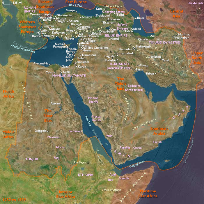
The subregion of The Near East includes modern Israel, Egypt, Sudan, most of Jordan, extreme southern Lebanon, western Saudi Arabia, western Yemen, southwestern Cyprus, and southwestern Turkey. Anchors comprised the Nile Valley and Delta, the Red Sea corridor with the Hejaz, the Yemeni highlands and Tihama coast, the Levantine uplands and coastal strip, and the southwest Anatolian and Cypriot Mediterranean littorals. These were zones of intensive agriculture, caravan and pilgrimage routes, and seaports connecting the Mediterranean to the Indian Ocean world.
Climate & Environmental Shifts
During the Little Ice Age, cooler winters and erratic rainfall shaped farming and settlement:
-
Nile Valley: Annual floods varied in intensity, producing alternating grain surpluses and shortfalls.
-
Western Yemen: Highland terraces maintained productivity despite irregular rainfall; drought struck the Tihama coast more severely.
-
Hejaz: Extremely arid, reliant on caravan supply and imported grain.
-
Levant & Cyprus: Wet–dry cycles influenced cereal, olive, and vine yields.
-
Sudan (Nubia): Nile-dependent sorghum fields thrived when floods were reliable, but low waters triggered famine and migration.
Subsistence & Settlement
-
Egypt: Irrigated wheat, barley, sugarcane, and fava beans in the Nile Valley and Delta; date palms, vegetables, and flax supplemented. Cairo was the metropolis and breadbasket.
-
Western Arabia: Dates, barley, and small gardens in oases; Mecca and Medina subsisted on caravans bringing Syrian and Egyptian grain.
-
Yemen: Terraced sorghum, wheat, fruits, and qat; goats and cattle in highlands; Red Sea ports like Aden imported rice and cloth.
-
Israel, Jordan, southern Lebanon: Wheat, barley, olives, and vines in uplands; pastoralism in steppe and desert margins.
-
Sudan: Sorghum, millet, and herding along the Nile corridor.
-
Cyprus & southwestern Anatolia: Grain, vines, olives, and sugar; coastal fishing supported towns like Antalya and Limassol.
Technology & Material Culture
-
Irrigation: Nile canals in Egypt; Yemeni terrace walls and cisterns; Jordanian and Levantine cistern systems.
-
Military: Mamluk cavalry and fortified cities in Egypt and Syria; Ottomans introduced siege artillery and gunpowder infantry, shifting regional power.
-
Architecture: Cairo’s mosques, madrasas, and caravanserais; Yemeni stone tower houses; Ottoman mosques rising in Anatolia; Orthodox monasteries in Cyprus.
-
Crafts: Egyptian glass, metalwork, and textiles; Yemeni ceramics; Levantine soap and sugar.
Movement & Interaction Corridors
-
Pilgrimage routes: Cairo and Damascus caravans supplied Mecca; Red Sea shipping funneled pilgrims to Jeddah.
-
Red Sea trade: Aden and Jeddah mediated flows of Indian Ocean spices, textiles, and horses.
-
Nile corridor: Moved grain and sugar from Upper Egypt to Alexandria and Cairo, then outward to Mediterranean markets.
-
Mediterranean ports: Alexandria, Limassol, and Antalya tied the Near East to Venice and Genoa.
-
Sudan–Nubia corridor: Linked gold, slaves, and sorghum north to Egypt.
Cultural & Symbolic Expressions
-
Islamic piety: Mamluk Cairo upheld legitimacy as protector of the holy cities; Mecca and Medina remained spiritual poles.
-
Sufism: Flourished through lodges in Cairo, Jerusalem, and Yemen; saints’ shrines anchored local devotion.
-
Christianity: Monasteries of Copts in Egypt, Armenians and Orthodox in Cyprus and Anatolia; Latin enclaves in Cyprus under Venetian rule.
-
Judaism: Thrived in Cairo, Jerusalem, and Safed (which became a center of mystical Kabbalah by the early 16th century).
-
Art & learning: Mamluk manuscripts and architecture in Cairo; Yemeni chronicles; early Ottoman architecture in Anatolia.
Environmental Adaptation & Resilience
-
Egypt: Stored grain in state and private granaries to offset poor Nile years.
-
Yemen: Terracing and cisterns captured rainfall; diversified crops mitigated drought.
-
Hejaz: Imported grain ensured survival; cisterns and wells sustained pilgrims.
-
Levant: Mixed farming of cereals, olives, and vines spread risk; steppe tribes balanced herding and raiding.
-
Sudan: Sorghum and millet cycles staggered planting to hedge against low Nile years.
Technology & Power Shifts (Conflict Dynamics)
-
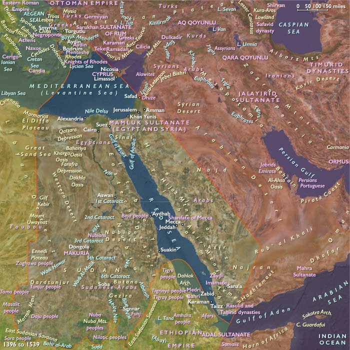
Mamluk Sultanate (Egypt, Syria, Hejaz): Maintained control until early 16th century; famed for cavalry, but weakened by plague and economic disruption from Portuguese diversion of spice trade.
-
Western Yemen: Rasulid then Tahirid dynasties ruled, but Zaydi imams contested highlands.
-
Ottoman advance: Captured Constantinople (1453), Antalya, and much of Anatolia; Selim I defeated Mamluks (1516–17), annexing Egypt, Syria, Hejaz, and securing Mecca and Medina.
-
Sudan: Christian Nubia declined; Muslim Funj sultanate rose in Sennar (early 16th century).
-
Portuguese intrusion: After Vasco da Gama (1498), Portuguese fleets disrupted Red Sea–Aden spice routes; naval clashes at Diu (1509) and Aden (1513).
-
Cyprus & Anatolia: Cyprus under Venetian rule; southwestern Anatolia absorbed into Ottoman domains.
Transition
By 1539 CE, the Near East had undergone a profound transformation. The Mamluk Sultanate had fallen; the Ottomans ruled Egypt, Hejaz, Levant, and southwestern Anatolia, presenting themselves as protectors of Islam’s holy cities. Western Yemen remained contested between local dynasties and Zaydi imams, while Aden felt the squeeze of Portuguese and Ottoman rivalry. Sudan’s Funj state emerged along the Nile. Cairo retained cultural centrality but was subordinated to Istanbul. Pilgrimage, Nile irrigation, and Indian Ocean trade still sustained livelihoods, but political hegemony had shifted decisively to the Ottoman sultans.
People
- Amara Dunqas
- Barsbay
- Catherine Cornaro
- Hayır Bey
- Helena Palaiologina
- James II of Cyprus
- John II of Cyprus
- Qaitbay
- Selim I
- Vasco da Gama
Groups
- Nubians
- Jews
- Alodia, or Alwa (Subah, or Soba), Kingdom of
- Islam
- Muslims, Sunni
- Muslims, Shi'a
- Christians, Roman Catholic
- Christians, Eastern Orthodox
- Venice, (Most Serene) Republic of
- Cyprus, Kingdom of
- Mongol Empire
- Ottoman Empire
- Egypt and Syria, Mamluk Burji Sultanate of
- Funj people
- Ottoman Empire
- Ottoman Empire
- Sennar, Funj Sultanate of
Topics
Commodoties
Subjects
Regions
Subregions
Related Events
Showing 10 events out of 43406 total
Years: 1396 - 1539
People
- Amara Dunqas
- Barsbay
- Catherine Cornaro
- Hayır Bey
- Helena Palaiologina
- James II of Cyprus
- John II of Cyprus
- Qaitbay
- Selim I
- Vasco da Gama
Groups
- Nubians
- Jews
- Alodia, or Alwa (Subah, or Soba), Kingdom of
- Islam
- Muslims, Sunni
- Muslims, Shi'a
- Christians, Roman Catholic
- Christians, Eastern Orthodox
- Venice, (Most Serene) Republic of
- Cyprus, Kingdom of
- Mongol Empire
- Ottoman Empire
- Egypt and Syria, Mamluk Burji Sultanate of
- Funj people
- Ottoman Empire
- Ottoman Empire
- Sennar, Funj Sultanate of
Topics
Commodoties
Subjects
Regions
Subregions