The Limes Germanicus (Latin for Germanic frontier) …
Years: 250 - 250
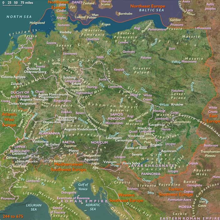
The Limes Germanicus (Latin for Germanic frontier) is a line of frontier (limes) fortifications that bound the Roman provinces of Germania Inferior, Germania Superior and Raetia, dividing the Roman Empire and the unsubdued Germanic tribes from the years 83 to about 260 CE.
At its height, the limes stretched from the North Sea outlet of the Rhine to near Regensburg on the Danube.
The Lower Germanic Limes extend from the North Sea at Katwijk in the Netherlands along the then main Lower Rhine branches (modern Oude Rijn, Leidse Rijn, Kromme Rijn, Nederrijn).
The Upper Germanic Limes start from the Rhine at Rheinbrohl (Neuwied (district)) across the Taunus mountains to the river Main (East of Hanau), then along the Main to Miltenberg, and from Osterburken (Neckar-Odenwald-Kreis) south to Lorch (Ostalbkreis) in a nearly perfect straight line of more than seventy kilometers.
The proper Rhaetian Limes extend east from Lorch to Eining (close to Kelheim) on the Danube.
The total length is five hundred and sixty-eight kilometers (three hundred and forty-one miles).
It includes at least sixty castles and nine hundred watchtowers.
The pressure of the barbarians had begun to be felt seriously in the later part of the second century, and after long struggles the whole or almost the whole district east of the Rhine and north of the Danube is lost, seemingly all within one short period, about 250.
Locations
Groups
- Gauls
- Germania
- Franks
- Germania Superior (Roman province)
- Germania Inferior (Roman province)
- Raetia (Roman province)
- Germans
- Syria Palæstina, Roman province of (Judea, Samaria, and Idumea)
- Alamanni (Germanic tribal alliance)
- Persian Empire, Sassanid, or Sasanid
- Roman Empire (Rome): Non-dynastic
- Gallic Empire
- Palmyrene Empire
Topics
Commodoties
Subjects
Regions
Subregions
Years: 250 - 250
Locations
Groups
- Gauls
- Germania
- Franks
- Germania Superior (Roman province)
- Germania Inferior (Roman province)
- Raetia (Roman province)
- Germans
- Syria Palæstina, Roman province of (Judea, Samaria, and Idumea)
- Alamanni (Germanic tribal alliance)
- Persian Empire, Sassanid, or Sasanid
- Roman Empire (Rome): Non-dynastic
- Gallic Empire
- Palmyrene Empire
Topics
Commodoties
Subjects
Regions
Subregions