The Khazar Empire, faced with the growing …
Years: 892 - 903
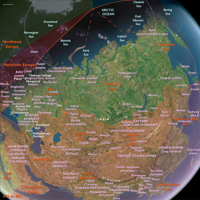
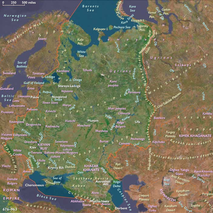
The Khazar Empire, faced with the growing might of the Pechenegs to their north and west and of the Russians around Kiev, suffers decline by the tenth century.
As the Khazar state can no longer impede the migration, the Pechenegs move westward, driving the Magyars into the Carpathian Basin and attacking Russian territory.
Locations
Groups
- Jews
- Hungarian people
- Hungarians, Realm of the (Etelköz)
- Khazar Khaganate
- Pechenegs, or Patzinaks
- Kievan Rus', or Kiev, Great Principality of
Topics
Commodoties
Subjects
Regions
Subregions
Related Events
Filter results
Showing 10 events out of 53685 total
The half-century-long colonization of some of the Hawaiian Islands by Polynesians from the Marquesas Islands and Tahiti is complete by 900.
The Hawaiian Islanders have established an economy based on “ahupuaa,” land units that extend from mountaintop to the sea.
Hawaiian religion, developed by at least 900, is based on a belief in gods existing in all forces and objects; a taboo, or “kapu,” system provides rules for maintaining the political and social order.
The Hawaiian Islanders’ hereditary ruling class, called the “alii nui,” reigns over the common people, who are primarily fishermen and farmers.
The Muslim writer Ahmad Ibn Rustah is so impressed with the wealth of Srivijaya's ruler that he declares around 903 that one will not hear of a king who is richer, stronger or with more revenue.
The first Yasodharapura is built around Phnom Bakheng, also referred to in inscriptions as Phnom Kandal (Central Mountain), constructed just before the foundation of the city due to Yasovarman's belief that the mountain is among the holiest of places to worship the Hindu deities.
Succeeding capitals built in the area will also be called Yasodharapura, which, when translated from the Sanskrit, conveys the meaning of "Holy City" or, by extension, "Capital City".
Central Java’s Shailendra kings build the last enormous stone Hindu temple complex, Chandi Lara Jonggrang, near the present village of Prambanan in around 900.
The so-called Prambanan complex incorporates two-hundred and-thirty-two separate temples, its towers adorned with rows of small Buddhist stupas in an illustration of how the two great Eastern religions intermingle in Indonesia.
The innermost of the complexes three courts, with an area of 1,184 square feet (110 square meters) contains the main tower shrine, sacred to the god Shiva, flanked by one to Vishnu and one to Brahma.
Facing these are three shrines dedicated to Shiva's bull Nandi and other images of his vehicles.
The main shrines all feature magnificent stone icons.
Bands of superb relief figure sculpture recounting Hindu epics, in a style derived from Borobudur, run around the terraces.
Sixty-two relief panels on the Shiva shrine’s exterior balustrade illustrate the classical dance.
The second concentric court, with an area of 2,390 square feet (222 meters) contains more than two hundred smaller shrines.
The Later Three Kingdoms of Korea (892–936) consists of Silla, Hubaekje ("Later Baekje") and Taebong, or Hugoguryeo ("Later Goguryeo"; it is replaced by Goryeo).
The latter two claim descent from the earlier Three Kingdoms of Korea, which had been united by Silla, even though Hugoguryeo has little to do with Goguryeo.
This period arises out of national unrest during the reign of Queen Jinseong of Silla, and usually refers to the era between the founding of Hubaekje by Gyeon Hwon to the time Goryeo unifies the peninsula.
Ahmad ibn Rustah travels to Novgorod with the Rus', and compiles books relating his own travels, as well as secondhand knowledge of the Khazars, Magyars, Slavs, Bulgars, and other peoples.
He writes of tenth-century city of the Rus': "As for the Rus, they live on an island … that takes three days to walk round and is covered with thick undergrowth and forests; … They harry the Slavs, using ships to reach them; they carry them off as slaves and … sell them.
They have no fields but simply live on what they get from the Slav's lands … When a son is born, the father will go up to the newborn baby, sword in hand; throwing it down, he says, 'I shall not leave you with any property: You have only what you can provide with this weapon.'"
His impression of the Rus' is very favorable: "They carry clean clothes and the men adorn themselves with bracelets and gold.
They treat their slaves well and also they carry exquisite clothes, because they put great effort in trade.
They have many towns.
They have a most friendly attitude towards foreigners and strangers who seek refuge."
This is in contrast to the account of Ibn Fadlan, whose views on hygiene (based on Islamic teachings on cleanliness and Islamic medical knowledge) contrast with that of the Rus'.
He noted that while the Rus' combed their hair and washed daily, they did so from the same bucket of water (which disgusted him personally).
Ibn Fadlan also notes that slaves were not mistreated by the Rus'.
The Decline of Classical Geography and the Rise of Symbolic Medieval Maps (c. 900 CE)
By 900 CE, the coordinate-based system of longitude and latitude—a hallmark of classical Greco-Roman cartography—disappears from Western European maps. This loss reflects the decline of classical geographical knowledge in the post-Carolingian period and marks a shift in the purpose and function of medieval maps.
Factors Contributing to the Loss of Longitude and Latitude
-
Decline of Classical Learning in the West
- The breakdown of centralized Carolingian authority leads to a decline in scholarly institutions, particularly in the study of Greek and Roman scientific texts.
- Knowledge of Ptolemaic cartography, which had been preserved in Late Antiquity, becomes increasingly inaccessible in Western Europe.
-
The Shift from Scientific to Religious and Political Cartography
- Medieval maps become less concerned with precise geographic representation and instead emphasize religious, spiritual, and political themes.
- The disappearance of latitude and longitude coincides with the rise of symbolic mapping traditions, such as:
- T-O maps, which place Jerusalem at the center of the world and divide the continents into Asia, Europe, and Africa.
- Mappa Mundi, which prioritize biblical history and sacred geography over empirical observation.
-
Lack of Standardized Measurements and Exploration
- Unlike the Roman Empire, which had vast surveying and road-building infrastructure, medieval Europe lacks state-sponsored geographic research.
- Navigation remains largely coastal, with limited need for coordinate-based mapping.
Consequences of the Shift in Cartography
- Maps become more schematic and symbolic, often used for theological instruction rather than practical navigation.
- Geographical distortions increase, as mapmakers rely on religious texts and travelers’ accounts rather than scientific calculations.
- Arab and Byzantine scholars preserve classical cartographic knowledge, ensuring that longitude and latitude will later be reintroduced to Europe through Islamic Spain and the Renaissance.
The Long-Term Impact
- The disappearance of coordinate-based mapping reflects the broader intellectual transformation of medieval Europe, where scientific knowledge is deprioritized in favor of theological worldviews.
- This loss is temporary; by the 12th and 13th centuries, renewed contact with Islamic and Byzantine scholarship will reintroduce classical geography to the Latin West, laying the groundwork for the Age of Exploration.
Thus, by 900 CE, medieval European maps cease to function as scientific tools and instead become expressions of Christian cosmology and political power, marking a significant departure from the geographic precision of the classical world.
Vikings of the 800s and 900s bury their important leaders in fully rigged ships beneath burial mounds, accompanied by a wealth of domestic utensils and funerary offerings.
The so-called Gokstad ship burial in southern Norway, dating to about 900, exemplifies Norse seagoing longships of the age.
Measuring more than seventy-five feet (twenty-three meters) long and seventeen feet (five and a quarter meters) wide, and built of oak and pine, with a heavy wooden keel and high prow and stern, its overlapping planks are nailed together and lashed to nineteen ribs and cross members.
Sixteen oar holes pierce each side of the hull; a corresponding thirty-two shields are mounted one over the next along the gunwales.
A single mast carries a huge square sail whose yard measures thirty-six feet (eleven meters) across.
An oar fixed at the aft end on the starboard side steers the ship.
The First Bulgarian Empire, East Francia, and Moravia, which had fought each other for control of the Carpathian Basin, had occasionally hired Hungarian horsemen as soldiers.
The Hungarians who dwelt in the eastern regions of the Pontic steppes were therefore familiar with their future homeland when they started their their "land-taking".
The ethnic configuration of the northern Balkans is altered permanently by invasions of Magyars from the steppe, who settle the Plain of Hungary, named for these fierce tribes of mounted nomads, and gain full control of the Carpathian Basin, including Transylvania.
The Hungarian conquest starts in the context of a "late or 'small' migration of peoples".
Contemporary sources attest that the Hungarians crossed the Carpathian Mountains following a joint attack in 894 or 895 by the Pechenegs and Bulgarians against them.
They first take control over the lowlands east of the River Danube and attack and in 900 occupy Pannonia (the region to the west of the river).
Exploiting internal conflicts in Moravia sometime between 902 and 906, the Hungarians annihilate this state.
East Central Europe (892–903 CE): Fragmentation of Great Moravia, Magyar Incursions, and Saxon Political Ascendancy
Between 892 and 903 CE, East Central Europe—comprising modern-day Poland, Czechia, Slovakia, Hungary, and eastern parts of Germany and Austria east of 10°E and north of a line from roughly 48.2°N at 10°E to the Austro-Slovenian border near 46.7°N, 15.4°E—underwent dramatic shifts driven by the fragmentation of Great Moravia, intensified Magyar (Hungarian) incursions, and the continued rise of the Liudolfing dynasty in Saxony. As centralized Carolingian authority weakened further, regional powers emerged or restructured, laying crucial foundations for the medieval geopolitical order.
Political and Military Developments
Fragmentation and Decline of Great Moravia
-
Following Svatopluk I’s death in 894 CE, Great Moravia rapidly fragmented due to internal rivalries, succession conflicts, and external pressures, severely weakening its cohesion and territorial integrity.
Arrival and Incursions of the Magyars
-
Around 895–896 CE, the Magyars migrated into the Carpathian Basin, launching devastating raids into Moravian, Bavarian, and Carolingian territories. These Magyar invasions decisively reshaped regional geopolitics, initiating significant demographic and political changes.
Saxon Dynastic Consolidation
-
Under Otto the Illustrious, the Saxon Liudolfing dynasty solidified its regional prominence amidst the decline of Carolingian power. Saxony emerged increasingly autonomous, strengthening administrative and military capabilities in response to external threats, notably the Magyar incursions.
Economic and Technological Developments
Economic Disruption and Realignment
-
Magyar raids significantly disrupted existing trade networks, particularly in Moravia and eastern Carolingian territories. Economic activity gradually realigned towards safer western Saxon and Bavarian regions, altering regional trade patterns and infrastructure priorities.
Intensified Defensive Construction
-
Heightened insecurity prompted extensive fortification improvements across Saxony, Bavaria, and remaining Moravian territories. These fortifications reflected a strategic shift toward defensive, militarized settlements.
Cultural and Artistic Developments
Disruption and Preservation of Moravian Culture
-
Although fragmented politically, Moravia’s cultural legacy persisted, particularly through continued ecclesiastical activities and preservation of the Cyril-Methodian tradition, despite political instability.
Saxon Cultural Confidence
-
The Liudolfings actively fostered Saxon cultural identity, integrating Carolingian traditions with local artistic styles, ecclesiastical patronage, and administrative practices, further solidifying Saxon distinctiveness.
Settlement and Urban Development
Decline of Moravian Centers
-
Key Moravian centers such as Mikulčice and Nitra experienced declines due to Magyar invasions and internal political fragmentation, shifting settlement patterns towards smaller, defensively organized settlements.
Growth of Saxon and Bavarian Towns
-
Despite disruptions, Saxon and Bavarian urban centers maintained relative stability and growth, benefiting from redirected trade routes and enhanced defensive measures.
Social and Religious Developments
Ecclesiastical Resilience amid Turmoil
-
Church institutions in Moravia, Saxony, and Bavaria demonstrated resilience, providing social cohesion and continuity amid political instability and military threats, preserving regional Christian traditions.
Consolidation of Saxon Social Hierarchy
-
In Saxony, the Liudolfings reinforced their social hierarchy, strengthening aristocratic and dynastic governance structures that provided essential stability in an otherwise volatile regional context.
Long-Term Consequences and Historical Significance
The era 892–903 CE marked a turning point in East Central European history. The collapse of Great Moravia, the destabilizing Magyar incursions, and Saxon political ascendancy significantly reshaped regional identities, political boundaries, and cultural trajectories. These events fundamentally reoriented East Central Europe's historical development, laying the groundwork for medieval political realignments, dynastic dominance, and new geopolitical realities.
Years: 892 - 903
Locations
Groups
- Jews
- Hungarian people
- Hungarians, Realm of the (Etelköz)
- Khazar Khaganate
- Pechenegs, or Patzinaks
- Kievan Rus', or Kiev, Great Principality of
