Noted European and American painters travel with …
Years: 1828 - 1839
Among those who encounter and paint the Assiniboine from life are painters Karl Bodmer and George Catlin.
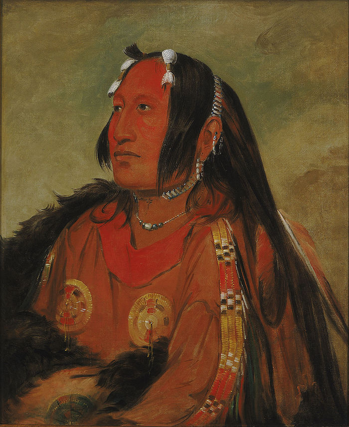
George Catlin: Wi-jún-jon, Pigeon's Egg Head (The Light), a Distinguished Young Warrior (1831), oil on canvas 73.6 cm (29 ″) x 60.9 cm (24 ″); Smithsonian American Art Museum. Catlin painted this subject at three different points in his life: young (this painting), then before and after the subject visited Washington, D.C. The warrior was ostracized by his tribe after he returned from Washington.
People
Groups
Topics
Subjects
Regions
Subregions
Related Events
Filter results
Showing 10 events out of 19829 total
The economically powerful nations of the globe industrialize, beginning with Great Britain in the eighteenth century and ending with Japan in the first quarter of the twentieth century.
Cast-iron architecture, followed by steel-frame construction, transforms the urban landscape.
Although organized warfare has plagued humanity for at least five or six thousand years, the period from the American revolution through the First World War matches war to industry in unprecedented ways, and with devastating results.
The Bessemer and open-hearth processes facilitate the manufacture of steel on a large scale.
The ghettos in western Europe are permanently abolished in the course of the nineteenth century.
In this age, the world’s civilized nations abolish slavery: the British, Empire in 1833; the United States, in 1863; and Brazil, in 1888.
This is not a universal emancipation, as Leopold’s Congo Free State and the French and Portuguese colonies of central Africa employ forced labor for the collection of ivory, and later rubber, until the first decade of the twentieth century.
The feudal monarchies of the Arabian Peninsula, notably Saudi Arabia and Kuwait, do not officially abolish slavery until 1965 and 1973, respectively, and the institution persists in parts of sub-Saharan Africa.
Northeastern Eurasia (1828–1971 CE)
From Tsarist Frontiers to Soviet Heartlands and Cold War Rimlands
Geography & Environmental Context
Northeastern Eurasia consists of three fixed subregions:
-
Northeast Asia — eastern Siberia (including Primorsky Krai), Sakhalin, the Chukchi Peninsula, Wrangel Island, Kuril Islands, and Hokkaidō (except its extreme southwest).
-
Northwest Asia — western and central Siberia from the Urals to roughly 130°E, including the West Siberian Plain, Altai, and the Central Siberian Plateau.
-
East Europe — the European portion of Russia, Belarus, and Ukraine, together with the Russian republics west of the Urals.
Anchors include the Arctic Ocean littoral (Kara, Laptev, and Okhotsk seas), the great river systems of the Ob–Irtysh, Yenisei, Lena, Amur–Ussuri, Dnieper, Don, and Volga, and the industrial–urban nodes of Leningrad (St. Petersburg), Moscow, Kyiv, Novosibirsk, Krasnoyarsk, Irkutsk, Vladivostok, and Sapporo. From tundra and taiga to loess plains and monsoon coasts, the region spans half the Northern Hemisphere’s climates and biomes.
Climate & Environmental Shifts
A sharply continental regime dominated interiors: long, frigid winters and short summers. The tail of the Little Ice Age persisted into the 19th century, then gave way to gradual warming, earlier river thaws, and glacier retreat in the Altai and Kamchatka by the mid-20th century. Periodic dzud winters devastated herds; drought pulses struck the Ukrainian steppe and Lower Volga (famines in the 1890s and early 1920s, and the Holodomor, 1932–33). In the Far East, typhoons and sea-ice shifts shaped fisheries; permafrost constrained construction across Siberia.
Subsistence & Settlement
-
Indigenous lifeways: Evenki, Nenets, Khanty, Chukchi, Koryak, Nivkh, Yupik, and Ainu sustained reindeer herding, sea-mammal hunting, fishing, trapping, and foraging—progressively curtailed by colonization, collectivization, and settlement policies.
-
Tsarist and Soviet expansion: Villages and penal settlements pushed east along the Trans-Siberian and river corridors; after 1917, collectivized agriculture and kolkhoz/sovkhoz systems reorganized the countryside of East Europe and southern Siberia.
-
Urbanization and industry: European Russia’s cities ( Moscow, Leningrad, Kyiv, Kharkiv, Donbas ) became heavy-industry cores; Siberia’s hubs ( Novosibirsk, Kemerovo, Krasnoyarsk, Irkutsk ) rose on coal, metals, and hydro, while Vladivostok, Khabarovsk, and Sapporo anchored the Pacific rim.
Technology & Material Culture
Railways (Trans-Siberian, 1891–1916; later Turk-Sib, branch lines) integrated steppe, taiga, and ports. Hydropower (e.g., Krasnoyarsk and Bratsk dams) and mining complexes transformed landscapes. In East Europe, steel, machine-building, and chemicals defined mass industrialization; in Northeast Asia, shipyards, ports, and fisheries expanded, while Hokkaidō underwent Meiji-to-postwar colonization and industrial growth. Everyday material culture shifted from log izbas and yurts to khrushchyovka apartments; radios, then TVs, entered homes by the 1960s.
Movement & Interaction Corridors
-
River highways: Seasonal shipping on the Ob, Yenisei, Lena, and Amur pre-dated and then fed rail hubs.
-
Trans-continental rails: Funneled grain, coal, ore, and people between European Russia and the Pacific; wartime evacuations (1941–42) relocated factories east.
-
Maritime arcs: The Okhotsk and Japan seas, Sakhalin–Hokkaidō–Kurils chain, and the Northern Sea Route(seasonal) tied fisheries, timber, and defense installations into Pacific networks.
-
Forced mobility: Tsarist exile and the Soviet Gulag (Kolyma, Norilsk, Vorkuta) drove coerced resettlement and resource extraction at massive human cost.
Cultural & Symbolic Expressions
Orthodox Christianity, Islam (in the Volga–Ural and North Caucasus margins of East Europe), Buddhism (Buryat and Mongol spheres), shamanic traditions, and—on Hokkaidō—suppressed Ainu culture framed identity against the rise of secular ideologies. Russian literature, music, and film radiated from Moscow and Leningrad; Soviet monumentalism and avant-gardes coexisted uneasily. Indigenous carving, song, and festival cycles persisted in Siberia and the Arctic, often underground, reviving visibly in the later 20th century.
Environmental Adaptation & Resilience
-
Permafrost engineering (pile foundations, winter roads) and taiga architecture enabled Siberian settlement.
-
Pastoral strategies: Herd diversification and seasonal migrations buffered dzud risk; state reindeer farms mixed traditional practice with planned quotas.
-
Agrarian adaptations: Shelterbelts, canals, and later the Virgin Lands campaigns extended cereal belts—often with soil erosion and dust storms by the 1960s.
-
Conservation beginnings: Zapovednik nature reserves (from 1916) protected representative biomes, even as industrial pollution rose in the Donbas, Upper Volga, and Kuzbass.
Political & Military Shocks
-
Tsarist consolidation and reform: The Emancipation of the Serfs (1861); Siberian penal colonization; the founding of Vladivostok (1860); Sakhalin as penal colony.
-
Revolution and Civil War (1917–22): Collapse of empire; shifting fronts across East Europe; creation of the USSR (1922).
-
Collectivization and terror: The Holodomor (1932–33) in Ukraine; purges; mass deportations to the Gulag and internal exiles in Siberia and the Far North.
-
Russo-Japanese War (1904–05) and Sakhalin/Kurils disputes; Hokkaidō settler colonialism and Ainu dispossession.
-
World War II: The Eastern Front ( Moscow, Stalingrad, Kursk, Leningrad ); devastation and liberation; Soviet seizure of southern Sakhalin and the Kurils (1945).
-
Cold War: East Europe as Soviet core; Northeast Asia militarized on both sides—the Pacific Fleet at Vladivostok; closed cities; the DEW Line/radar arcs in the Arctic; border incidents along the Amur by the late 1960s.
Transition
Between 1828 and 1971, Northeastern Eurasia was remade from a mosaic of imperial frontiers and Indigenous homelands into the industrial heartlands and strategic rimlands of two modern states: the USSR and Japan. Railways, mines, and dams bound taiga and tundra to Moscow; Hokkaidō’s Meiji-to-postwar transformation integrated it into Japan’s national economy. The costs were immense—famines, repression, deportations, cultural suppression—yet the region also generated vast material output and scientific achievement. By 1971, Northeastern Eurasia stood as a Cold War fulcrum: East Europe anchoring Soviet power, Northwest Asia supplying raw materials and hydro-electricity, and Northeast Asia bristling with fleets, airbases, and fisheries—its peoples negotiating survival and renewal between permafrost, ports, and power blocs.
Northeast Asia (1828–1971 CE): Tsarist Frontiers, Imperial Japan, and Cold War Divisions
Geography & Environmental Context
Northeast Asia includes eastern Siberia (east of 130°E, including Primorsky Krai and Sakhalin), northeastern Heilongjiang in China, the Chukchi Peninsula, Wrangel Island, and Hokkaidō (except its extreme southwest). Anchors include the Amur and Ussuri river basins, the Sea of Okhotsk, the Kamchatka Peninsula, and the Kuril Islands. The region combines Arctic tundra, boreal taiga, volcanic arcs, and rich marine coasts.
Climate & Environmental Shifts
A sharply continental climate defined the region: long winters, permafrost, and short summers. Droughts and harsh freezes (dzud) devastated herds in Siberian and Amur zones. Volcanic eruptions on Kamchatka and earthquakes in Sakhalin and Hokkaidō periodically destroyed settlements. Sea ice patterns shaped fishing and navigation. After 1945, industrialization and nuclear testing added new ecological pressures.
Subsistence & Settlement
-
Indigenous lifeways: Chukchi, Even, Koryak, and Nivkh peoples herded reindeer, hunted seals and whales, fished rivers, and gathered wild plants.
-
Russian settlement: From the mid-19th century, Tsarist Russia expanded along the Amur and into Primorsky Krai, founding Vladivostok (1860). Sakhalin became a penal colony.
-
Japanese settlement: Hokkaidō was colonized intensively after 1869, displacing Ainu through farming, fishing, and mining.
-
20th century: Soviet collectivization transformed Siberian villages; reindeer herding was reorganized into state farms. Postwar, Vladivostok, Khabarovsk, and Magadan became industrial hubs; Norilsk and Kolyma further west relied on forced labor.
Technology & Material Culture
-
Transport: River steamers plied the Amur; the Trans-Siberian Railway (1891–1916) tied Vladivostok to Moscow. Japan built railroads and ports in Hokkaidō. Postwar, Soviet highways, airfields, and gulag transport routes extended deep into the taiga.
-
Industry: Fishing, fur trade, timber, coal (Sakhalin), and later oil and military industries dominated. Hokkaidō developed mining, steel, and agriculture.
-
Everyday life: Yurts and wooden huts persisted in Siberia, while Soviet apartments (khrushchyovki) and Japanese wooden houses spread in urbanizing zones. Radios, sewing machines, and later TVs entered households after 1945.
Movement & Interaction Corridors
-
Tsarist conquest: Treaties of Aigun (1858) and Peking (1860) gave Russia the Amur–Ussuri territories.
-
Japanese expansion: Hokkaidō fully colonized; Sakhalin and the Kurils contested in Russo-Japanese War (1904–05).
-
Labor & exile: Penal labor on Sakhalin; Soviet deportations and gulags (Kolyma) forced millions east.
-
Military corridors: WWII saw Japanese control of southern Sakhalin and Kurils; Soviets seized them in 1945. Cold War militarization followed.
Cultural & Symbolic Expressions
-
Indigenous traditions: Shamanic ceremonies, reindeer festivals, and whale rituals persisted under suppression.
-
Colonial suppression: Ainu were displaced and assimilated in Japan; Nivkh and Chukchi were collectivized in USSR.
-
Literature: Accounts of exile (Chekhov on Sakhalin, 1890), gulag memoirs, and Japanese colonial writings depicted the region as harsh frontier.
-
Identity: Soviet patriotism celebrated Far Eastern development; Japan romanticized Hokkaidō as a northern frontier.
Environmental Adaptation & Resilience
-
Nomadic strategies: Reindeer herding diversified herds across tundra and taiga.
-
Fishing adaptation: Salmon runs sustained both Indigenous and settler economies; Soviet trawlers industrialized fisheries.
-
Cold adaptation: Fur clothing, log cabins, and later insulated housing ensured survival.
-
Modern pressures: Mining, deforestation, and gulag projects scarred landscapes but also supported settlement.
Political & Military Shocks
-
Russian empire: Secured Amur and Primorye in mid-19th century; Sakhalin developed as penal colony.
-
Russo-Japanese War (1904–05): Japan seized southern Sakhalin and challenged Russian Pacific presence.
-
World War II: Soviet offensives in 1945 seized Kurils and southern Sakhalin; Indigenous and Japanese civilians displaced.
-
Cold War: Vladivostok became closed Soviet naval base; Kurils remained disputed. Hokkaidō developed rapidly within U.S.-allied Japan, hosting defense installations.
-
Repression: Soviet collectivization, gulag labor, and forced sedentarization of nomads; Japanese assimilation of Ainu.
Transition
From 1828 to 1971, Northeast Asia transformed from Indigenous homelands and penal colonies into a militarized frontier of empires and Cold War blocs. Tsarist Russia absorbed Amur and Primorye, while Japan colonized Hokkaidō and contested Sakhalin and Kurils. WWII and Soviet offensives redrew borders, displacing populations. Collectivization, gulags, and industrialization under the USSR, and modernization in Hokkaidō under Japan, altered lifeways profoundly. By 1971, Northeast Asia was a land of naval bases, mines, fisheries, and Cold War garrisons, where Indigenous cultures persisted in fragments beneath the weight of empire and modern state power.
Northern North America (1828–1971 CE): Industrial Nations, Expanding Frontiers, and Cold War Geographies
Geography & Environmental Context
Northern North America encompasses the United States and Canada, excluding the West Indies, and divides into three subregions with fixed boundaries:
-
Northeastern North America: east of 110°W, including the Great Lakes–St. Lawrence basin, Hudson Bay, Labrador, Newfoundland, Greenland, the Atlantic seaboard from New England through Virginia, the Carolinas, and most of Georgia, as well as the Mississippi Valley north of Illinois’ Little Egypt, the Upper Missouri above the Iowa–Nebraska crossing, northeast Alabama, central and eastern Tennessee, and nearly all of Kentucky.
-
Northwestern North America: west of 110°W, including Alaska, the Yukon, British Columbia, Alberta west of 110°W, Washington, Oregon north of the Gulf line, northern Idaho, the northwestern portions of Montana, and northern California above the Gulf line.
-
Gulf and Western North America: the wedge south of the Montana diagonal, including nearly all of Florida, the lower Mississippi Valley, the southern Plains, the arid Southwest, and California south of the Oregon line.
This continental span contained Arctic tundra and boreal forest, Great Plains and Mississippi bottomlands, Appalachian and Pacific cordilleras, subtropical deltas, and Mediterranean California.
Climate & Environmental Shifts
The Little Ice Age ebbed by the mid-19th century, followed by gradual warming. Droughts and hurricanes repeatedly struck the Plains and Gulf coasts, while the Dust Bowl (1930s) devastated farms in the southern Plains. Industrial expansion brought deforestation, coal smoke, and polluted rivers, especially in the Great Lakes. Massive dams and irrigation systems — from the Hoover Dam to the St. Lawrence Seaway — transformed landscapes. Greenland’s ice and Arctic permafrost remained defining constraints, even as Cold War bases pushed into icy terrain.
Subsistence & Settlement
-
Indigenous nations: Confined to reserves and reservations, often by force, yet maintained ceremonies, farming, and mixed economies.
-
United States: Expanded westward through annexations and conquest, fought a Civil War (1861–65), and by the 20th century became a global power. Its economy diversified: cotton and tobacco in the South, corn and wheat in the Midwest, ranching on the Plains, citrus and irrigated crops in California, oil in Texas and Oklahoma, and industry in the Great Lakes and Northeast.
-
Canada: Achieved Confederation in 1867, expanded westward, and industrialized through Montreal, Toronto, and Halifax, while prairie farming drew settlers. By the mid-20th century, Canada asserted sovereignty as a bilingual, bicultural nation.
-
Greenland: Remained Danish until 1953, when it became a province; Inuit lifeways of hunting and fishing endured alongside missions, trade posts, and military installations.
Technology & Material Culture
Railways, canals, and steamships in the 19th century gave way to highways, aviation, and electronics in the 20th. Industrial mass production reshaped daily life: automobiles, telegraphs, radios, and televisions transformed communication and culture. In Alaska, British Columbia, and the Pacific Northwest, salmon canneries, sawmills, and oil pipelines redefined economies. Skyscrapers rose in New York, Chicago, and Los Angeles; Hollywood studios and aerospace plants symbolized Gulf & Western modernity. Inuit and Native traditions — from totem carving to powwows and drum dances — persisted, often underground, before revival by the mid-20th century.
Movement & Interaction Corridors
-
Rivers & canals: The Mississippi remained a backbone; the St. Lawrence Seaway (1959) linked Great Lakes industry to the Atlantic.
-
Overland trails & railways: Oregon and Santa Fe Trails gave way to transcontinental railroads, highways, and pipelines.
-
Maritime & global trade: Gulf ports tied into the Caribbean and Atlantic; California ports linked to Asia. The Panama Canal (1914) fused Gulf and Pacific economies.
-
Air & Cold War routes: Alaska became an airbridge to Asia in WWII; DEW Line radar stations made the Arctic a Cold War front line.
Cultural & Symbolic Expressions
-
Indigenous resilience: Ceremonies, art, and oral traditions preserved identity under dispossession; 20th-century activism began cultural resurgence.
-
African American culture: From the Gulf South arose blues, jazz, and gospel — later shaping global music.
-
Mexican American communities: In Texas, New Mexico, Arizona, and California, bilingual and Catholic traditions defined regional life.
-
National mythologies: The “Wild West,” the frontier, and the wilderness became symbolic narratives in both nations. Hollywood, national parks, and skyscrapers embodied progress and identity.
-
Greenland Inuit: Hunting songs, carvings, and drum dances blended with Lutheranism and Cold War geopolitics.
Environmental Adaptation & Resilience
-
Farming: Mechanization and fertilizers boosted yields but stressed soils; Dust Bowl crises spurred conservation.
-
Water control: Dams, aqueducts, and irrigation turned deserts into farmland but altered ecosystems.
-
Conservation: National parks and wildlife laws reflected emerging ecological awareness.
-
Urban resilience: Cities rebuilt after fires, earthquakes, and storms; suburbs spread after WWII.
Political & Military Shocks
-
United States: Expanded via wars with Mexico (1846–48) and Native nations; fought a Civil War; emerged from two World Wars as a superpower; became a Cold War leader.
-
Canada: Consolidated federation, expanded to the Pacific, and by the 20th century gained full sovereignty from Britain.
-
Greenland: Shifted from colony to province of Denmark, with U.S. military bases central to Cold War defense.
-
Indigenous dispossession: Trail of Tears, Plains wars, reservations, and residential schools inflicted deep trauma, yet mid-20th-century activism laid groundwork for revival.
Transition
Between 1828 and 1971, Northern North America transformed into a continent of industrial democracies, resource frontiers, and Cold War battlegrounds. The United States emerged as a global superpower; Canada matured into a sovereign federation; Greenland became strategically vital. Indigenous, African American, and Mexican American communities endured dispossession and marginalization but defined much of the continent’s cultural vitality. By 1971, the subregion was at once an engine of global industry, a crucible of diverse identities, and a geopolitical frontier, carrying into the late 20th century the legacies of expansion, exploitation, resilience, and renewal.
Gulf and Western North America (1828–1971 CE): Frontiers, States, and Modern Transformations
Geography & Environmental Context
Gulf and Western North America includes Mississippi, Louisiana, Arkansas, Texas, Oklahoma, Kansas, New Mexico, Colorado, Wyoming, Arizona, Utah, Nevada, nearly all of California (except the far northwest), nearly all of Florida (except the extreme northeast), southwestern Georgia, most of Alabama, southwestern Tennessee, southern Illinois, southwestern Missouri, most of Nebraska, southeastern South Dakota, southern Montana, southern Idaho, and southeastern Oregon.
Anchors include the Mississippi delta, the Rio Grande valley, the Great Plains, the California goldfields, and the Gulf of Mexico coast. This was a subregion of fertile river valleys, hurricane-prone coasts, semi-arid plains, deserts, and Mediterranean California — each shaping distinctive economies and settlement patterns.
Climate & Environmental Shifts
The 19th century brought drought cycles to the Great Plains and Southwest, while hurricanes devastated the Gulf Coast. The Dust Bowl of the 1930s compounded ecological crisis, as soil exhaustion and drought displaced thousands. California’s Mediterranean climate supported orchards, vineyards, and irrigated agriculture. The Colorado, Rio Grande, and other rivers were dammed for hydroelectricity and irrigation, transforming deserts into farmland.
Subsistence & Settlement
-
Indigenous nations: Dispossession accelerated through wars, forced removals, and reservations. Yet ceremonial life, farming, and pastoral practices persisted, especially among Pueblo, Navajo, Apache, and Plains peoples.
-
Expansion & statehood:
-
Texas Revolution (1836) and the U.S.–Mexican War (1846–48) brought vast new lands under U.S. control.
-
California Gold Rush (1849) spurred mass migration, diversifying populations.
-
New states formed from frontier territories, incorporating the Plains and Southwest into the U.S. federation.
-
-
Agriculture & economy:
-
Cotton, sugar, and rice thrived in the Gulf South under slavery until the Civil War (1861–65); after emancipation, sharecropping dominated.
-
Plains ranching expanded, even as bison herds were decimated.
-
California shifted to orchards, citrus, and irrigated farming, while railroads knit coast to interior.
-
-
Urbanization: Gulf ports like New Orleans, Houston, and Galveston grew as trade hubs. In the 20th century, cities such as Los Angeles, Dallas, and San Francisco surged with oil, film, aerospace, and high-tech industries.
Technology & Material Culture
-
Transport revolutions: Steamboats dominated the Mississippi in the early 19th century; railroads crossed the Plains by mid-century; automobiles, highways, and aviation reshaped the 20th century.
-
Resource frontiers: Oil fields in Texas, Oklahoma, and California transformed the subregion into an energy powerhouse.
-
Architecture: Spanish missions, plantation houses, adobe pueblos, and frontier cabins persisted alongside skyscrapers, freeways, and Hollywood studios.
-
Cultural production: From blues and jazz in the Gulf South to Hollywood cinema in California, the subregion’s material culture became globally influential.
Movement & Interaction Corridors
-
Rivers: The Mississippi remained the backbone of transport until railways superseded it.
-
Overland trails: The Santa Fe and Oregon Trails carried settlers westward.
-
Maritime & global routes: The Gulf tied Louisiana and Texas to Caribbean and Atlantic trade; California ports connected to Asia. The Panama Canal (1914) enhanced Gulf–Pacific linkages.
-
Migration: Dust Bowl migrants moved west in the 1930s; Mexican laborers sustained agriculture through the Bracero Program (1942–64).
Cultural & Symbolic Expressions
-
Indigenous traditions: Pueblo dances, Navajo weaving, and Plains ceremonies persisted, often underground, before revival in the 20th century.
-
African American culture: The Gulf South nurtured blues, jazz, and gospel, globalizing regional experience.
-
Mexican American communities: Preserved fiestas, Catholic devotions, and bilingual traditions across Texas, New Mexico, Arizona, and California.
-
National mythologies: Frontier individualism, cowboy culture, and the “Wild West” became enduring symbols. Hollywood amplified these themes worldwide.
Environmental Adaptation & Resilience
-
Agriculture: Irrigation, aqueducts, and dams (Hoover Dam, Central Valley Project) transformed deserts into productive farmland.
-
Disaster response: Coastal levees and relief programs confronted hurricanes; soil conservation and New Deal programs addressed Dust Bowl conditions.
-
Communities: Adapted to industrial booms and busts, civil rights struggles, and rapid urbanization while retaining distinct Indigenous, African American, and Mexican American cultural resilience.
Political & Military Shocks
-
U.S. expansion: Texas annexation, Mexican-American War, and the California Gold Rush anchored continental growth.
-
Civil War: The Gulf South was a Confederate heartland; defeat ended slavery but entrenched racial inequality.
-
Native American conflicts: Plains wars, Navajo Long Walk (1864), and Apache resistance marked dispossession.
-
20th-century transformations: Oil wealth, aerospace, and military installations (from San Antonio to Los Angeles) tied the subregion to U.S. global power. Civil rights and labor movements reshaped social landscapes.
Transition
By 1971, Gulf and Western North America had been fully absorbed into the United States, yet it retained deep cultural pluralism. Indigenous nations, African Americans, and Mexican Americans endured marginalization but defined much of the region’s cultural life. Oil derricks, rail hubs, Hollywood studios, and aerospace centers symbolized modern transformation. From the Gulf Coast to California, the subregion was both an industrial powerhouse and cultural crucible, shaping the modern identity of the United States.
Polynesia (1828–1971 CE)
Missions, Colonial Rule, Nuclear Era, and Islander Revivals
Geography & Environmental Context
Polynesia in this framework consists of three fixed subregions:
-
North Polynesia: the Hawaiian Islands except the Big Island of Hawai‘i (i.e., O‘ahu, Maui, Kaua‘i, Moloka‘i, Lāna‘i, Ni‘ihau, Kaho‘olawe) plus Midway Atoll.
-
West Polynesia: the Big Island of Hawai‘i, Tonga, Samoa, Tuvalu, Tokelau, the Cook Islands, and French Polynesia (Tahiti, Society Islands, Tuamotus, Marquesas).
-
East Polynesia: Pitcairn Island and Rapa Nui (Easter Island).
Across these archipelagos, tropical trade-wind climates prevail, with cyclone belts affecting Samoa, the Cooks, Tuvalu, and Tokelau; volcanic high islands (Hawai‘i, Tahiti, Savai‘i, Upolu) contrast with low coral atolls (Marsh–Tuamotu chains). Reef fisheries, taro and breadfruit groves, and limited freshwater lenses defined ecological limits, while population growth and 20th-century militarization increased pressure on land and lagoons.
Climate & Environmental Shifts
The late 19th century saw variable El Niño–Southern Oscillation (ENSO) events that brought droughts to atolls and heavy rains to high islands. Cyclones periodically devastated coastal settlements and breadfruit groves. In the mid-20th century, runway construction, urbanization, and lagoon dredging altered local hydrology, while radioactive fallout (from French tests in French Polynesia from 1966 and upwind U.S. tests in Micronesia earlier) entered regional anxiety and health debates.
Subsistence & Settlement
-
High islands maintained mixed gardens (taro, yams, bananas), breadfruit orchards, pigs, and intensive reef fishing; plantation sectors (sugar, pineapple in Hawai‘i; copra in French Polynesia, the Cooks, Tuvalu, Tokelau) linked families to cash.
-
Atolls relied on coconuts, preserved breadfruit, pulaka/taro pits, and lagoon fisheries, supplemented by remittances and colonial rations in bad years.
-
Urban hubs—Honolulu (North Polynesia), Apia and Nuku‘alofa (West Polynesia), Pape‘ete (French Polynesia), and Hanga Roa (Rapa Nui)—grew with missions, administration, shipping, and (after WWII) air travel and tourism.
Technology & Material Culture
Mission schools and printing presses spread literacy; schooners and later steamships knit archipelago economies. After 1900, outboard motors, radios, and concrete housing transformed daily life; airfields (e.g., O‘ahu, Tahiti, Rarotonga, Faleolo) opened long-haul links. Material culture hybridized: tapa and fine mats continued alongside cotton cloth; canoe carving persisted while aluminum boats proliferated; church architecture stood beside fale and hale vernacular.
Movement & Interaction Corridors
-
Labor and migration: 19th-century contract labor fed plantations (especially Hawai‘i), followed by 20th-century migration to New Zealand, Australia, and the U.S.; seasonal inter-island voyaging persisted for family, church, and trade.
-
Shipping and air routes: Honolulu and Pape‘ete became trans-Pacific nodes; Apia and Rarotonga connected West Polynesia to Auckland and Sydney.
-
War corridors: WWII militarized North and West Polynesia; bases, runways, and garrisons left long-term economic and environmental footprints.
Cultural & Symbolic Expressions
Christianity became dominant across Polynesia, but customary authority (chiefly systems, matai titles, kāhui ariki)and ritual continued, often braided with church life. Hula, ‘ori Tahiti, siva Samoa, and haka (in nearby Aotearoa/NZ) flourished in new performance circuits, while language retention movements gathered momentum after WWII. In East Polynesia, Pitcairn’s Bounty-descendant culture and Rapa Nui’s rongorongo legacy and moai landscape shaped strong place-based identities.
Environmental Adaptation & Resilience
Atoll communities relied on breadfruit fermentation pits, cisterns, and inter-island kin networks for famine relief. Reef tenure and customary closures (e.g., ra‘ui/kapu) protected fisheries. After cyclones, rebuilding mobilized church groups and village labor. Cash-crop volatility was buffered by subsistence gardens and migration remittances.
Political & Military Shocks
-
North Polynesia: Overthrow of the Hawaiian Kingdom (1893) and U.S. annexation (1898) culminated in statehood (1959); Honolulu became a U.S. military and tourism hub; Midway a strategic naval/air base (Battle of Midway, 1942).
-
West Polynesia:
-
Western Samoa gained independence (1962) after the non-violent Mau movement.
-
Tonga preserved monarchy under treaties; full independence (1970).
-
Cook Islands entered free association with NZ (1965); Tokelau remained NZ-administered; Tuvalu was within the Gilbert & Ellice colony (separation later, 1978).
-
French Polynesia remained under France; nuclear testing at Moruroa and Fangataufa from 1966 triggered protest and laid foundations for autonomy debates.
-
Hawai‘i’s Big Island industrialized sugar/pineapple early, then diversified with tourism and military links as part of the new U.S. state.
-
-
East Polynesia: Pitcairn remained a small British colony (with migration to Norfolk); Rapa Nui was annexed by Chile (1888), leased to ranching companies, and militarized in the mid-20th century, constraining land access and fueling later autonomy claims.
Transition
By 1971, Polynesia had moved from missionary kingdoms and colonial protectorates to a mosaic of independent states, free-association polities, colonies, and a U.S. state. War-time infrastructures, air routes, and mass tourism reoriented economies; diaspora networks tied villages to Auckland, Honolulu, Sydney, and Los Angeles. Nuclear testing in French Polynesia cast a long shadow, while cultural revivals reclaimed dance, language, and chiefly authority. Across atolls and high islands, custom and Christianity, remittances and reefs together sustained Polynesian resilience in the modern era.
North Polynesia (1828–1971 CE): Colonial Annexations, U.S. Statehood, and Islander Diasporas
Geography & Environmental Context
North Polynesia includes the Hawaiian Islands (except the Big Island, which belongs to West Polynesia) and Midway Atoll. Anchors include the volcanic islands of O‘ahu, Maui, Kaua‘i, Moloka‘i, Ni‘ihau, and atolls like Midway. The environment combined high-island volcanic soils and lush valleys with fragile atoll ecologies. A subtropical climate moderated by trade winds supported sugarcane and pineapple plantations, while reefs and fisheries underpinned subsistence.
Climate & Environmental Shifts
Seasonal rainfall sustained taro terraces and plantation crops, though droughts occasionally affected leeward coasts. Hurricanes, while less frequent than further south, periodically damaged crops and settlements. After 1900, deforestation, plantation expansion, and urban sprawl around Honolulu altered ecosystems. By the mid-20th century, military bases and tourism reshaped landscapes, and nuclear testing fallout from the Marshalls (to the southwest) touched North Polynesian waters.
Subsistence & Settlement
-
Traditional lifeways: Taro terraces, breadfruit groves, fishing, and pig husbandry persisted in rural valleys, often alongside plantations.
-
Plantations: Sugarcane (from early 19th century) and later pineapple dominated economies; plantations relied on immigrant labor—Chinese, Japanese, Portuguese, Filipino.
-
Urban centers: Honolulu expanded into a port, capital, and tourist hub; Pearl Harbor became a naval anchor. Smaller towns like Lahaina and Hilo supported plantations and fisheries.
-
Midway: Guano mining (19th century), later a cable and air station, then a key U.S. naval base.
Technology & Material Culture
-
19th century: Whaling fleets used Honolulu as a provisioning hub; missionary presses introduced literacy, Bibles, and Western schooling.
-
20th century: Railroads and trucks hauled cane; irrigation ditches transformed valleys; radios, sewing machines, and later televisions spread into households. Hotels, hula shows, and surf culture created hybrid modern traditions.
-
Military infrastructure: Airstrips, bunkers, and shipyards transformed O‘ahu and Midway, especially during WWII.
Movement & Interaction Corridors
-
Whaling & trade: Honolulu became a central provisioning port for Pacific fleets.
-
Labor migration: Thousands of workers from Asia and Portugal reshaped demographics and culture.
-
Tourism: From the early 20th century, Honolulu developed into a Pacific resort, accelerated after WWII with jet travel.
-
Military corridors: Pearl Harbor became the linchpin of U.S. Pacific defense; Midway’s naval base was decisive in WWII. Postwar, Hawai‘i remained a hub for Cold War deployments.
Cultural & Symbolic Expressions
-
Hawaiian monarchy: Retained sovereignty until U.S. overthrow of Queen Lili‘uokalani (1893). Hawaiian language, hula, and chants preserved heritage amid missionary and settler suppression.
-
Hybrid culture: Immigrant traditions blended with Native Hawaiian life—Japanese bon dances, Portuguese malasadas, Filipino music, all mixing with hula and slack-key guitar.
-
Religion: Christianity dominated after missionary efforts, but Hawaiian cosmologies endured in rural practice and revivals.
-
Nationalism: Hawaiian sovereignty movements persisted underground after annexation, resurfacing in the mid-20th century.
Environmental Adaptation & Resilience
-
Traditional strategies: Irrigated taro terraces and fishponds maintained food security, especially in valleys beyond plantation zones.
-
Plantation adaptation: Immigrant households cultivated backyard gardens, mixing taro, rice, bananas, and pigs for resilience.
-
Tourism & military: Hawaiians adapted by merging traditions with new economies—hula in hotels, lei-making for visitors, land leased for bases.
Political & Military Shocks
-
Colonial encounters:
-
1820s–1890s: Missionaries, whalers, and traders eroded Hawaiian sovereignty.
-
1893: Overthrow of Hawaiian monarchy by American planters and U.S. Marines.
-
1898: Annexation by the United States.
-
-
Territorial status: Hawai‘i governed as U.S. territory (1900–1959).
-
World War II: Pearl Harbor attacked (1941); Hawai‘i under martial law until 1944; Midway battle (1942) pivotal in Pacific war.
-
Statehood: Hawai‘i became the 50th U.S. state in 1959, with booming tourism, military, and government jobs.
Transition
Between 1828 and 1971, North Polynesia transformed from a Hawaiian kingdom into a U.S. state at the crossroads of empire and the Pacific. Plantation labor, immigration, and missionary schooling reshaped demographics and culture; Pearl Harbor and Midway thrust it into world war and Cold War geopolitics. Hawaiian traditions endured amid suppression and commodification, fueling mid-20th-century revival. By 1971, North Polynesia was both a strategic military bastion and a tourism-driven economy—its Indigenous sovereignty constrained but its culture resilient, and its identity increasingly central to Pacific politics.
West Polynesia (1828–1971 CE): Chiefly States, Colonial Rule, and the Making of Modern Island Nations
Geography & Environmental Context
West Polynesia comprises the Big Island of Hawai‘i, Tonga, Samoa, Tuvalu, Tokelau, the Cook Islands, and French Polynesia (Tahiti, Society Islands, Tuamotus, Marquesas). Anchors include the volcanic high islands of Hawai‘i, Savai‘i, Upolu, and Tahiti, the atoll chains of Tuvalu and Tokelau, and the reef-fringed lagoons of the Cooks and Society Islands. Tropical climates with trade winds, cyclones, and El Niño variability shaped agriculture and fisheries.
Climate & Environmental Shifts
Cyclones periodically devastated atolls, ruining breadfruit and coconut crops; volcanic activity in Hawai‘i continued to add land and hazards. Drought pulses alternated with heavy rains. After WWII, population growth, urbanization, and tourism increased stress on reefs, water, and soils.
Subsistence & Settlement
-
Agriculture & fishing: Taro terraces, breadfruit groves, bananas, and coconuts anchored diets; reef fishing and pelagic catches provided protein.
-
Colonial economies: Missionization, copra, cotton (briefly during the U.S. Civil War), and later phosphate (in nearby Banaba) reoriented production.
-
Urbanization: Honolulu grew into a Pacific hub; Apia and Nuku‘alofa consolidated as capitals; Pape‘ete became an administrative and tourism center. Rural–urban migration accelerated after 1950.
-
Land tenure: Customary land systems persisted in Samoa and Tonga, while French and British colonial laws altered tenure in Tahiti and the Cooks.
Technology & Material Culture
-
19th century: Sailing canoes gave way to schooners and steamers; missions introduced literacy, printing presses, and churches.
-
20th century: Radios, outboard motors, concrete housing, and airstrips changed daily life. Hawai‘i industrialized sugar and pineapple; Tahiti saw early tourism.
-
Everyday culture: Tapa cloth, mats, and canoe carving endured; hymnals, guitars, and radios hybridized musical traditions.
Movement & Interaction Corridors
-
Migration: Contract labor flowed to plantations in Hawai‘i and Fiji; later, migration to New Zealand, Australia, and the U.S. expanded.
-
Shipping & air routes: Honolulu linked Asia and the Americas; inter-island schooners and postwar airlines connected archipelagos.
-
War corridors: WWII militarized Hawai‘i, Samoa, and Tahiti; bases and troop movements transformed economies and gender roles.
Cultural & Symbolic Expressions
-
Religion: Christianity became dominant; denominations mapped onto village life.
-
Chiefly systems: Tonga retained monarchy; Samoa balanced matai (chiefly) titles with colonial administrations; Hawai‘i’s monarchy was overthrown (1893), annexed by the U.S. (1898).
-
Nationalism & culture: Samoan Mau movement (1920s–30s) pressed for self-rule; hula and Hawaiian language revival gained momentum mid-20th century; Tahitian and Cook Islands dance and song flourished; sport (rugby) became a regional identity marker.
Environmental Adaptation & Resilience
-
Food security: Breadfruit fermentation pits, taro terraces, and reef tenure buffered storms and droughts.
-
Customary stewardship: Ra‘ui and kapu–style closures protected fisheries and sacred sites; adaptation persisted under colonial pressure.
-
Postwar economies: Remittances and military spending stabilized small islands; atolls coped with freshwater scarcity via cisterns.
Political & Military Shocks
-
Colonization: Britain, France, Germany, and the U.S. divided the region—Hawai‘i annexed (1898), American and German Samoa partitioned (1899), French protectorate over Tahiti (1842).
-
WWII: Hawai‘i placed under martial law; Samoa and Tahiti supplied bases; Pacific war reshaped geopolitics.
-
Decolonization: Western Samoa achieved independence (1962); Cook Islands (1965) and later Niue entered free association with New Zealand; French Polynesia remained French (later nuclear testing site, post-1960s). Tonga stayed independent but under treaties.
Transition
Between 1828 and 1971, West Polynesia traveled from missionary kingdoms and colonial rule to self-governing island nations and diaspora networks. Sugar and pineapple reshaped Hawai‘i; Samoa’s Mau movement pioneered Polynesian nonviolent nationalism; Tonga navigated independence through treaties; French Polynesia moved toward greater autonomy under French control. By 1971, Polynesian societies combined church, chiefs, and modern states, sustained by remittances, customary land, and a growing Pacific identity—poised for late-20th-century debates over nuclear testing, tourism, and sovereignty.
Micronesia (1828–1971 CE)
Empires, War, and the Long Road to Self-Determination
Geography & Environmental Context
Micronesia comprises two fixed subregions:
-
West Micronesia: the Mariana Islands (including Guam and Saipan) and the Caroline Islands (Palau, Yap, Chuuk, Pohnpei, Kosrae).
-
East Micronesia: the Marshall Islands, Kiribati (Gilbert Islands), and outlying eastern Carolines.
Together they form a constellation of volcanic high islands, coral atolls, and low reef platforms spread across millions of square kilometers of the western and central Pacific. Each relied on fragile freshwater lenses, breadfruit and coconut groves, and rich reef fisheries.
Climate & Environmental Shifts
Tropical trade winds and the oscillating El Niño–Southern Oscillation (ENSO) produced alternating droughts and heavy rains. Cyclones occasionally destroyed breadfruit and coconut trees; droughts threatened taro pits on atolls. Colonial copra plantations and wartime construction damaged fragile ecosystems. In the mid-20th century, U.S. nuclear testing in the Marshalls (1946–58) contaminated land and sea, while population displacement and coastal erosion worsened under new infrastructure and population pressure.
Subsistence & Settlement
Traditional horticulture—taro, breadfruit, pandanus, bananas, and coconuts—remained central. Fishing and inter-atoll exchange provided protein and salt. Colonial rule reoriented economies toward copra and later wage labor:
-
Spanish rule lingered until the late 19th century, followed by German administration (1899–1914) emphasizing copra.
-
Japanese mandate (1914–1944) industrialized sugar, fishing, and shipping networks, and established schools, ports, and airfields, drawing Japanese settlers to Saipan, Palau, and Chuuk.
-
After World War II, the United States Trust Territory of the Pacific Islands (TTPI, 1947) unified most of Micronesia under U.N. mandate, bringing cash employment, U.S. education, and aid dependence.
Technology & Material Culture
Indigenous canoe and navigation traditions persisted in parts of Yap, Palau, and the Marshalls. Missions and colonial governments introduced iron tools, printed cloth, and concrete housing. Japanese period architecture—sugar mills, piers, and warehouses—left enduring marks. After 1945, U.S. administration introduced radios, diesel generators, prefabricated schools, and modern shipping. Traditional arts—canoe carving, weaving, shell ornament—continued, increasingly as symbols of identity.
Movement & Interaction Corridors
-
Maritime networks: Islanders maintained canoe routes linking atolls for kinship and trade; colonial steamers later replaced them.
-
Labor migration: Men traveled to work on plantations, ships, and military bases; after WWII, educational and labor programs sent Micronesians to Guam, Hawai‘i, and the continental U.S.
-
Military geography: The islands formed a key Pacific battleground during WWII—Guam, Saipan, Palau, and the Marshalls endured fierce fighting. Postwar bases at Kwajalein, Guam, and Yap tied the region to Cold War strategy.
Cultural & Symbolic Expressions
Christianity—Catholic and Protestant—became dominant but intertwined with traditional cosmologies. Oral histories, navigation chants, and lineage rituals survived under mission influence. Japanese schools spread literacy before 1945; after 1947, U.S. schooling in English created a new educated elite. Political identity coalesced through the Congress of Micronesia (1965), foreshadowing later independence movements.
Environmental Adaptation & Resilience
Atoll dwellers preserved breadfruit fermentation and inter-island reciprocity to withstand famine. After cyclones, communities replanted coconuts and taro and relied on church networks for relief. Environmental knowledge of winds, reefs, and tides remained central even as modern technology arrived. In the nuclear-test zones of Bikini and Enewetak, displaced islanders rebuilt new villages on distant atolls, maintaining cohesion through shared rituals and appeals for restitution.
Political & Military Shocks
-
Colonial succession: Spain → Germany → Japan → United States.
-
World War II: Devastation from battles at Saipan, Palau, Truk Lagoon, and Tarawa; massive civilian displacement.
-
Nuclear testing: Bikini and Enewetak atolls (1946–58) used for U.S. weapons tests, displacing populations and spreading radiation.
-
Postwar governance: The Trust Territory (1947) placed Micronesia under U.S. administration with U.N. oversight; by the 1960s, local legislatures and constitutional conventions moved toward self-government.
-
Strategic islands: Guam and Saipan integrated as U.S. territories; Palau and the Marshalls negotiated special compacts; Kiribati moved toward British-led independence (achieved 1979).
Transition
Between 1828 and 1971, Micronesia journeyed from missionized atolls and colonial plantations to a fragmented constellation of Cold War dependencies and emerging nations. The 19th century brought European and Japanese imperial control; World War II brought devastation; the U.S. Trust Territory introduced education and aid but also dependency and nuclear trauma. Through it all, Micronesian societies retained core resilience—canoe voyaging, clan solidarity, and spiritual reciprocity with land and sea. By 1971, the region stood poised for decolonization, its people navigating between the legacies of empire and the assertion of renewed island sovereignty.
East Micronesia (1828–1971 CE)
Atolls under Empire, Nuclear Shadows, and Independence Movements
Geography & Environmental Context
East Micronesia includes the Marshall Islands, Kiribati (Gilbert Islands), and parts of eastern Caroline Islands. Anchors include the low coral atolls of Bikini, Enewetak, Tarawa, Majuro, and volcanic outliers in eastern Carolines. These fragile islands depended on thin soils, freshwater lenses, and reef resources.
Climate & Environmental Shifts
Equatorial sun, trade winds, and seasonal rains sustained coconut groves, taro pits, and breadfruit trees. Typhoons and droughts threatened atolls. Rising copra demand in the 19th century reshaped land use. From 1946, nuclear testing at Bikini and Enewetak devastated environments, displacing communities and contaminating ecosystems.
Subsistence & Settlement
-
Traditional: Fishing, taro pits, breadfruit fermentation, and coconut cultivation sustained households. Canoes linked atolls for exchange.
-
Colonial economies: Copra plantations dominated under German, British, and later Japanese administration.
-
20th century: Japanese rule (1914–1944) militarized atolls, introducing schools, sugar works, and garrisons. Postwar U.S. trusteeship shifted subsistence economies toward aid dependence.
Technology & Material Culture
-
Sailing canoes remained crucial into the 20th century; missions introduced literacy and hymnals.
-
Japanese rule: Concrete bunkers, ports, and airstrips built in the Marshalls and Gilberts.
-
U.S. era: Nuclear facilities at Bikini and Enewetak, military airfields (Kwajalein), and weather stations. Radios, sewing machines, and prefabricated housing spread after WWII.
Movement & Interaction Corridors
-
Colonial transfers: Spanish ceded Carolines and Marshalls to Germany (1899); Japan occupied after 1914; U.S. assumed control in 1947 under UN trusteeship.
-
War: Marshall and Gilbert atolls (Tarawa, Kwajalein) saw decisive WWII battles.
-
Displacement: Bikini and Enewetak islanders were relocated multiple times for U.S. nuclear testing.
-
Migration: Islanders began moving to Guam, Hawaii, and mainland U.S. under trust-era migration programs.
Cultural & Symbolic Expressions
-
Religion: Catholic and Protestant missions reshaped ritual life; Christianity fused with atoll traditions.
-
Oral traditions: Navigation chants, genealogies, and myths persisted alongside literacy.
-
Nuclear experience: Bikini and Enewetak exile produced laments, songs, and petitions to the UN, embedding global justice narratives.
-
Nationalism: Political movements in the 1960s pressed for independence, autonomy, or free association.
Environmental Adaptation & Resilience
-
Food storage: Breadfruit pits, dried fish, and taro provided insurance.
-
Inter-atoll exchange: Canoe voyaging redistributed food in famine.
-
Colonial coping: Islanders balanced copra production with gardens.
-
Postwar dependence: Rations and aid substituted for lost autonomy; displaced Bikini islanders relied on imported foods.
Political & Military Shocks
-
Colonial succession: Spain → Germany → Japan → United States trusteeship.
-
World War II: Battles at Tarawa and Kwajalein left mass destruction.
-
Cold War: U.S. nuclear testing (1946–58) displaced islanders, sparking protests.
-
Decolonization: By the late 1960s, the Marshalls, Gilberts, and Carolines pressed for independence within or outside U.S. frameworks.
Transition
Between 1828 and 1971, East Micronesia transitioned from remote atoll societies to highly strategic Cold War outposts. Copra trade, missionization, and Japanese militarization had already altered lifeways, but U.S. nuclear testing and trusteeship uprooted entire communities. Despite environmental fragility and political subordination, Micronesians retained strong cultural traditions of navigation, kinship, and oral history while mobilizing for self-determination. By 1971, East Micronesia was poised to enter an independence era shadowed by both nuclear trauma and enduring resilience.
Years: 1828 - 1839
George Catlin: Wi-jún-jon, Pigeon's Egg Head (The Light), a Distinguished Young Warrior (1831), oil on canvas 73.6 cm (29 ″) x 60.9 cm (24 ″); Smithsonian American Art Museum. Catlin painted this subject at three different points in his life: young (this painting), then before and after the subject visited Washington, D.C. The warrior was ostracized by his tribe after he returned from Washington.
People
Groups
Topics
Subjects
Regions
Subregions