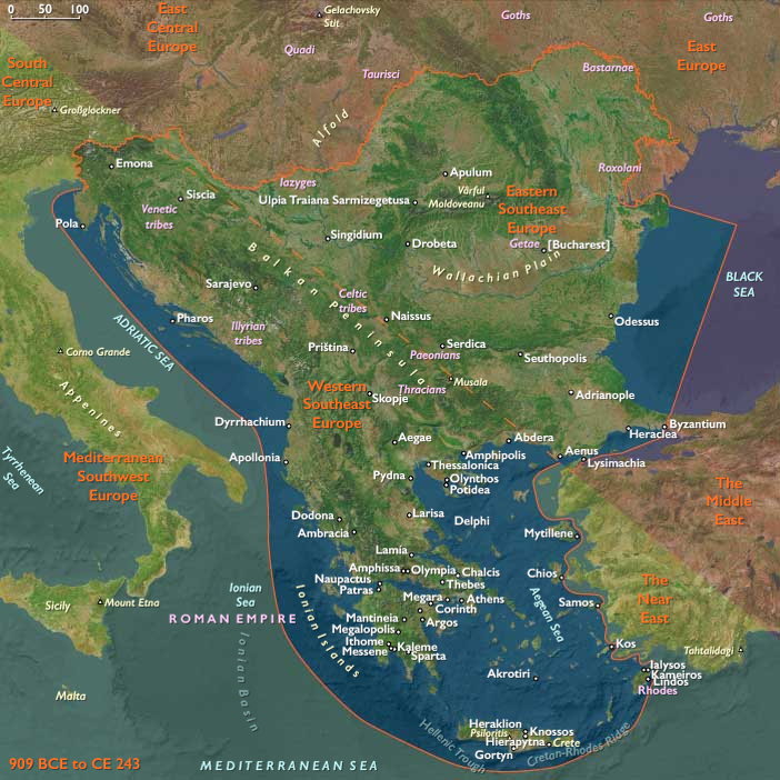
The island of Delos, isolated in the …
Years: 909BCE - 898BCE
The island of Delos, isolated in the center of the roughly circular ring of islands called the Cyclades, near Mykonos, had had a position as a holy sanctuary for a millennium before Olympian Greek mythology made it the birthplace of Apollo and Artemis.
By the time of the Odyssey, the island was already famous as the birthplace of the twin gods.
Sacred Delos from 900 BCE becomes a major cult center, where Dionysus is also in evidence, as well as the Titaness Leto, mother of the divine twins.
Investigation of ancient stone huts found on the island indicate that it has been inhabited since the third millennium BCE.
Thucydides identifies the original inhabitants as piratical Carians who were eventually expelled by King Minos of Crete.
Locations
Groups
Topics
Commodoties
Subjects
Regions
Subregions
Related Events
Filter results
Showing 10 events out of 66848 total
Northeastern Eurasia (909 BCE – 819 CE): Steppe Empires, River Kingdoms, and Forest–Sea Frontiers
Regional Overview
Spanning from the Ural steppes to the Amur River, Northeastern Eurasia was a continental hinge where grasslands, forests, and subarctic coasts met.
It was never a single civilization but an interacting system of three complementary worlds:
-
the Northwest Asian steppes—a domain of horse nomads and shifting empires;
-
the Northeast Asian river–coastal zone—home to Amur polities, sealers, and proto-Ainu cultivators;
-
and the East European forest–steppe—a land of Scythians, Greek ports, and Slavic beginnings.
Across these ecotones, mobility, exchange, and adaptation to cold defined life and linked peoples from the Black Sea to the Pacific.
Geography and Environment
The region’s immensity embraced the Ural Mountains, Ob–Yenisei–Lena river systems, Altai–Sayan uplands, and the Amur–Okhotsk basin.
-
In the steppe belt (Northwest Asia and East Europe), open grasslands favored pastoral nomadism and mounted warfare.
-
In the taiga and tundra, dense forests and rivers sustained hunters and trappers.
-
Along the Amur and Okhotsk coasts, salmon rivers and seal rookeries supported maritime specialists.
Cold winters, brief summers, and erratic rainfall required mobility: herding on the plains, riverine storage, and seaborne subsistence at the coasts.
Climatic fluctuations shifted pastures and forest margins, driving the migrations that repeatedly reshaped this vast northern world.
Societies and Political Developments
The Northwest Steppes: Riders and Confederacies
Early Saka–Scythian cultures (1st millennium BCE) pioneered mounted archery, burial mounds, and trade routes linking the Altai to the Black Sea.
Their successors—the Xiongnu, Huns, and Türkic Khaganates—forged nomadic empires between the 3rd century BCE and the 8th century CE, commanding the Eurasian steppe road.
Pastoral clans of Sarmatians, Saka, and later Turks traded horses, felt, and slaves for silk, metalwork, and glass, while Ket, Samoyedic, and Evenki forest peoples maintained autonomy through trapping and fishing.
The East European Forest–Steppe: Traders, Farmers, and Frontiers
Between the Dniester and the Volga, Scythian and later Sarmatian riders ruled the Pontic plains; Greek colonies such as Olbia, Chersonesus, and Bosporus exported grain and slaves to the Mediterranean.
In the forest–steppe, Balts, Finno-Ugrians, and Slavic ancestors lived in mixed economies of farming, beekeeping, and fur trade.
By the early centuries CE, the Chernyakhiv culture bridged steppe and forest zones; later, Goths, Huns, and Avars swept westward, followed by the Khazars, who by the 7th century commanded the lower Volga.
Early Slavic settlements spread through the Dnieper basin, foreshadowing Kyivan Rus’.
The Amur–Okhotsk Northeast: River Chiefdoms and Sea Hunters
In the far east, Sushen/Mohe polities along the Amur taxed fish, furs, and horses, governing plank-built towns with storage pits and palisades.
Coastal Okhotsk communities specialized in sealing, whaling, and oil rendering, while inland clans hunted elk and reindeer.
On northern Hokkaidō, the Epi-Jōmon culture gave way to early Satsumon societies, incorporating iron tools and small-scale cultivation—precursors to later Ainu identity.
These eastern networks interacted with the Korean and Chinese frontiers, feeding iron, silk, and ceramics into local economies.
Economy and Exchange
Trade and mobility united the region more than empire or language.
Three great corridors structured movement:
-
The Steppe Road, carrying silk, metals, and horses between China, Persia, and the Black Sea.
-
The River Arteries, where the Ob, Yenisei, and Volga funneled furs, wax, and fish to southern markets.
-
The Amur–Okhotsk–Sakhalin Circuit, exchanging seal oil, ivory, and iron among coastal peoples.
Greek ports, Turkic caravan cities, and Amur villages each served as nodes of this transcontinental traffic.
Technology and Material Culture
Iron transformed toolkits across all zones: swords and plowshares in the steppe, adzes and awls in the taiga, harpoons and knives on the coast.
The stirrup and saddle revolutionized steppe warfare; dugout canoes and skin boats extended inland and maritime reach.
Pottery traditions remained diverse—black-burnished wares in the steppe, cord-impressed in the forest, thick-walled cooking jars in the Amur basin.
Animal-style art, petroglyphs, and totemic carvings reveal a shared aesthetic of motion and metamorphosis across peoples separated by thousands of kilometers.
Belief and Symbolism
Religion everywhere mirrored ecology.
-
Steppe nomads worshiped the Sky-God Tengri and honored ancestors through kurgan burials.
-
Forest and river peoples followed shamanic cosmologies tied to animals, trees, and water spirits.
-
Along the Amur and Okhotsk coasts, bear-sending rituals and first-salmon feasts expressed reciprocity with nature.
Greek colonies introduced Mediterranean cults, while Khazar and Bulgar elites later adopted Judaism and Islam—diversity without uniformity.
Adaptation and Resilience
Survival depended on mobility, diversity, and exchange.
Nomads tracked rainfall across steppe belts; hunters stored dried fish and smoked meat; sealers preserved oil in skin bags for the long winter.
The integration of horse, reindeer, and dog traction multiplied travel options; iron tools extended fuel and housing resources.
Polities rose and fell with climate and trade, yet the regional system endured through flexible kin alliances and shared environmental knowledge.
Regional Synthesis and Long-Term Significance
By 819 CE, Northeastern Eurasia was a mature transcontinental world:
-
The Northwest steppes had evolved from Scythian to Türkic empires, perfecting cavalry and steppe diplomacy.
-
The East European forests and rivers nurtured Slavic and Finno-Ugric communities, integrating them into the Khazar and Bulgar trade webs.
-
The Northeast river–coastal arc blended Amur chiefdoms, Okhotsk sealers, and proto-Ainu cultivators, joining the Asian mainland to the North Pacific.
This tri-zonal equilibrium—steppe mobility, forest production, maritime specialization—defined the ecological and cultural balance of northern Eurasia.
Out of it would emerge the medieval Turkic and Mongolic empires, the Rus’ river states, and the Ainu and Japanese North Pacific frontier, each inheriting the mobility, adaptability, and cosmopolitan exchange first forged in this early age.
Northeast Asia (909 BCE – 819 CE): River Kingdoms, Coastal Specialists, and Toward Satsumon and Okhotsk
Northeast Asia includes eastern Siberia east of the Lena River to the Pacific, the Russian Far East (excluding the southern Primorsky/Vladivostok corner), northern Hokkaidō (above its southwestern peninsula), and extreme northeastern Heilongjiang.
-
Anchors: Lower Amur polities (proto-Mohe/Sushen), Ussuri towns, Sakhalin landing nodes, Okhotsk seal/whale stations, northern Hokkaidō (Epi-Jōmon → Satsumon trajectory).
Climate & Environmental Shifts
-
First-millennium variability; ice-edge polynyas reliable; river freeze–thaw structured travel calendars.
Subsistence & Settlement
-
Amur river kingdoms consolidated tribute in fish, furs, and horses; fortified villages with plank halls and big storage.
-
Okhotsk coastal specialists (mid–late 1st millennium CE) mastered sealing/whaling, dog-keeping, and winter oil technologies; shell mounds and bear rites diagnostic.
-
Northern Hokkaidō transitioned from Epi-Jōmon to early Satsumon (late in period), with pottery change, iron use, and limited cultivation at southern margins.
Technology & Material Culture
-
Iron from mainland routes integrated into knives, awls, spearheads; bone harpoons with toggling heads remained indispensable.
-
Pottery diversified (thicker-walled cooking/storage), soapstone lamps, leather/skin parkas; skis and snowshoes inland.
Movement & Interaction Corridors
-
Amur–Sungari–Korean axis funneled iron and horses; Sakhalin–Hokkaidō ferries moved metals and ceramics; Okhotsk coastal runs spread salt and oils.
Cultural & Symbolic Expressions
-
Bear-sending rituals, first-salmon rites, and ancestor memorials knit communities; lineage emblems appeared on grave goods and house posts.
Environmental Adaptation & Resilience
-
Tri-zonal adaptation (riverine storage, coastal sealing, taiga hunting) created redundancy; iron adoption enhanced woodworking/canoe repair and sewing.
Legacy & Transition
By 819 CE, Northeast Asia exhibited the cultural precursors of the medieval Okhotsk sphere and Hokkaidō’s Satsumon communities—maritime specialists and riverine chiefdoms enmeshed in Amur–Japan Sea exchange, setting the stage for later Ainu ethnogenesis and North Pacific interactions.
From ASTt to Old Bering Sea, Okvik, and Punuk
On the western side of the Arctic, innovation accelerated. By the second century CE, the Old Bering Sea culture flourished along the Alaskan and Chukotkan coasts and on the islands between. Its artisans created engraved ivory harpoon heads and tools, marrying artistry with maritime hunting of seals, walrus, and whales.
By the mid-third century, the Okvik culture emerged on the Punuk Islands, carving bold spirals and faces into ivory and developing a distinctive stylistic identity while continuing marine subsistence.
Finally, by the late seventh century, the Punuk culture spread across the Strait. Their subterranean houses framed with whale jawbones, and their focus on cooperative whale hunts, marked a major shift to larger, more permanent settlements and complex social life.
This west Arctic trajectory culminated in the maturation of the Thule tradition, which would soon expand eastward to reshape all of Arctic North America.
Northern North America (909 BCE – 819 CE): From Arctic Seas to Riverine Towns — The Deep Foundations of the Continent
Regional Overview
From the drifting pack ice of the Arctic Ocean to the salmon canyons of the Fraser and Columbia, and from the birch forests of the Great Lakes to the mounds of the Mississippi, Northern North America in the first millennium BCE through the early centuries CE formed a continental lattice of waterways, fisheries, and overland trails.
Across this vast region, societies diversified around the rhythm of rivers and the reach of coastlines — Arctic seal hunters, Pacific longhouse chiefs, Woodland farmers, and Plains foragers each adapting to their ecologies while linked through far-flung exchange.
By 819 CE, the northern half of the continent had achieved a remarkable cultural equilibrium: stable regional traditions, robust interzonal trade, and the institutional seeds that would flower into the Thule migrations, Mississippian towns, and Northwest Coast chiefdoms of the coming age.
Geography and Environment
Northern North America embraced the Arctic littoral, the North Pacific coast, the continental interior, and the temperate forests bordering the Atlantic.
-
The Arctic and subarctic stretched from the Yukon to Baffin Bay, its coasts ruled by sea-ice cycles and river estuaries rich in fish and seals.
-
The Northwest Coast offered mild, wet climates and dense conifer forests, sustaining some of the highest population densities north of Mesoamerica.
-
The Interior Plains and Plateaus were threaded by the Mississippi, Missouri, and Columbia systems — arteries of migration and exchange.
-
The Northeastern woodlands combined mixed farming with forest hunting, while the Great Lakes and St. Lawrence corridors linked interior and Atlantic ecologies.
Climatic variability shaped mobility rather than collapse: alternating warm and cool pulses adjusted the balance between farming and foraging, while vast ecological diversity ensured regional resilience.
Societies and Political Developments
Arctic and Subarctic Horizons
In the western Arctic, the Norton tradition (c. 1000 BCE – 800 CE) established semi-subterranean house villages, oil-lamp economies, and net fisheries across Alaska’s bays and rivers.
By the mid-first millennium CE, Birnirk innovations — sea-ice whaling, toggling harpoons, refined bone and ivory craft — emerged on the North Slope, setting the technological stage for the Thule expansion.
Inland, Athabaskan foragers managed caribou and salmon cycles through flexible band networks stretching from the Yukon to the Mackenzie.
The North Pacific Coast
Southward, the ranked longhouse societies of the Haida, Tlingit, Tsimshian, and related peoples achieved a mature social hierarchy centuries before written history: hereditary chiefs, clan crests, and ceremonial redistribution through feast-traditions ancestral to the later potlatch.
Villages of massive cedar plank houses lined Haida Gwaii, the central BC fjords, and the Puget Sound.
Farther inland, Plateau communities along the Fraser and Columbia Rivers built pit-house towns near salmon canyons, tightly integrated with coastal exchange.
The Eastern Woodlands and Arctic Threshold
In the east, Late Woodland cultures consolidated from the Great Lakes to the Appalachians.
Fortified longhouse villages in Ontario and New York foreshadowed Iroquoian confederacies.
Southward along the Mississippi–Ohio system, mound centers continued the Hopewell legacy and anticipated Mississippian complexity.
On the Atlantic, shell-heap villages thrived from Chesapeake to the Gulf of Maine.
Farther north, Dorset Paleo-Inuit traditions persisted across the Eastern Arctic, with the coming Thule and, later, Norse Greenlanders still centuries ahead.
Economy and Trade
Across the region, economic life revolved around seasonal abundance and long-distance circulation.
-
Arctic and Subarctic peoples balanced sea-mammal hunting, fishing, and caribou herding, exchanging furs, ivory, and stone for metal and wood from the south.
-
Coastal chiefdoms specialized in salmon, eulachon oil, cedar timber, and carved prestige goods of copper and shell, exported inland along “grease trails.”
-
Interior and Woodland farmers combined maize, beans, and squash with hunting and fishing; their towns became marketplaces for copper, obsidian, mica, and shell ornaments.
-
River and lake corridors — Yukon, Fraser, Columbia, Mississippi, St. Lawrence — functioned as the highways of pre-Columbian North America, linking ecological zones into continental exchange.
Technology and Material Culture
Technological ingenuity was universal yet regionally distinct.
-
Arctic engineers developed the qayaq and umiak, bone-framed sleds, toggling harpoons, and oil lamps for polar survival.
-
Northwest Coast carpenters perfected adzes, chisels, and caulking for seaworthy canoes and monumental architecture.
-
Woodland artisans produced cord-marked pottery, copper ornaments, and polished stone tools.
-
Irrigation in the desert Southwest (to the south) influenced maize cultivation reaching the Lower Mississippi; meanwhile, storage pits, smoking racks, and plank granaries became standard food-security technologies across the temperate north.
Belief and Symbolism
Religious and ceremonial life bound ecology to ancestry.
-
Along the Pacific Coast, first-salmon rites, crest art, and mortuary feasts articulated kin identity and ecological reciprocity.
-
In the Woodlands, mound burials, clan totems, and cosmologies of the four directions organized both ritual and landscape design.
-
In the Arctic, shamanic traditions mediated between human and animal spirits, honoring the souls of seals, whales, and caribou.
Art, dance, and ritual reaffirmed the moral equilibrium between community and environment, making cosmology a practical guide for survival.
Adaptation and Resilience
Environmental diversity bred redundancy and cooperation.
Food storage, alliance marriages, and ritual feasting functioned as social insurance systems against famine or climatic shock.
Riverine and coastal corridors allowed mobility when drought, ice, or conflict disrupted one zone.
Technological convergence — woodcraft, metallurgy, navigation, and agriculture — produced a continental safety net of knowledge.
Regional Synthesis and Long-Term Significance
By 819 CE, Northern North America had matured into a web of complementary cultural systems:
-
Arctic Norton–Birnirk foragers poised for the Thule transformation;
-
Northwest Coast longhouse chiefdoms achieving classical complexity;
-
Interior and Woodland farmers consolidating the Late Woodland world;
-
Atlantic and Great Lakes peoples connecting interior and ocean through canoe exchange.
This mosaic — continental in scale yet locally precise — provided the infrastructure for the continent’s medieval efflorescence: Thule migrations across the Arctic, the rise of Cahokia and its mound-town network, and the flourishing of Northwest Coast monumental art.
In environmental and cultural resilience, Northern North America was already a mature world — one whose diversity and interconnection would shape the hemispheric story for centuries to come.
Northwestern North America (909 BCE – 819 CE) Norton and Birnirk North, Ranked Longhouses South — Toward Thule and Classic Northwest Coast
Geographic and Environmental Context
Northwestern North America includes Alaska, western Canada (Alberta, British Columbia, Yukon and Northwest territory and Nunavut west of 110°W) Alaska, Washington State, northern Idaho, and the northwestern portions of Montana, Oregon, and California.
-
Anchors: Norton Sound–Kotzebue Sound (Norton tradition), Brooks Range–North Slope (Birnirk precursors), Cook Inlet–Prince William Sound, Haida Gwaii–Northern/ Central BC coasts, Fraser–Columbia–Plateau town belts, Puget Sound.
Climate & Environmental Shifts
-
First-millennium variability; productive fisheries persisted; sea-ice season structured Arctic hunting.
Subsistence & Settlement
-
Norton tradition (c. 1000 BCE–800 CE) in the western Arctic: large semi-subterranean houses, net fisheries, oil lamps, ceramics; broad marine–riverine economies.
-
Late in the period, Birnirk elements (c. 600–1000 CE) appeared on the North Slope—specialized sea-ice sealing/whaling technologies—foreshadowing Thule.
-
Coastal Northwest: fully developed ranked plank-house villages with hereditary house-lineages controlling fisheries, cedar, and canoe landings; monumental houses rose along Haida Gwaii and the Central Coast.
-
Interior Plateau: dense pit-house towns leveraged salmon canyons (Fraser/Columbia), integrated with coastal exchange.
Technology & Material Culture
-
Arctic: pottery, lamps, toggling harpoons, qayaq/umiak precursors; driftwood sledges; bone/ivory working refined.
-
Coast: heavy adze/chisel carpentry; large sea-going canoes; shell-bead and copper wealth items; standardized net systems.
-
Interior: ground-stone toolkits, fishing gaffs, storage bins.
Movement & Interaction Corridors
-
Arctic: migratory arcs along sea-ice edges; Norton trade into interior for lithics and pyroclastics.
-
Coast–Interior: eulachon “grease” trails ferried oil inland; obsidian and antler–horn moved coastwise.
Cultural & Symbolic Expressions
-
First-salmon rituals, whale/seal ceremonies, and crest/lineage art consolidated social memory.
-
Mortuary diversity: house-area interments, formal cemeteries, and burial cairns.
Environmental Adaptation & Resilience
-
Route redundancy (ice-edge, riverine, and coastal lanes) maintained flows under climatic oscillations; storage economies and social insurance (feasts, alliance marriages) offset shocks.
Transition
By 819 CE, Northwestern North America was a tripartite cultural mosaic: Norton/Birnirk Arctic societies poised for Thule expansion; ranked longhouse polities on the North Pacific Coast approaching their classic florescence; and interior plateau towns tightly integrated into salmon and grease-trail economies — a foundation for the medieval transformations already underway by 820–963 CE.
Polynesia (909 BCE – 819 CE): The Post-Lapita Ocean — Navigation Perfected and Worlds Awaiting Settlement
Regional Overview
Across the heart of the Pacific, the first millennium BCE to the early first millennium CE marked the transformation of Polynesia from an idea in motion — the open ocean itself — into a system of distinct cultural and ecological zones.
By this age, the Lapita legacy of seafaring, horticulture, and ornament had matured into the classical Polynesian navigational and genealogical complex.
The great triangle of future Polynesia was taking recognizable form: West Polynesia—anchored in Tonga and Samoa—was fully settled; East Polynesia, though distant, was now within the reach of long-range exploration; and North Polynesia (the Hawaiian chain) remained on the horizon of voyaging knowledge, its high islands still untouched by human settlement but already “seen” in oral cartographies of the sea.
Geography and Environment
The Polynesian ocean forms a single ecological field: volcanic high islands with fertile soils, reef-fringed lagoons, and far-flung low atolls.
Climates varied from humid tropical in the Samoan–Tongan cores to cool-temperate in future New Zealand’s approaches, but winds and currents — especially the steady southeast trades and seasonal westerlies — unified the region.
These conditions produced both navigational stability and ecological diversity: breadfruit and taro belts in the high islands, pandanus and coconut groves on the atolls, and vast seabird rookeries in the unpeopled margins of the north and east.
Voyaging and Cultural Transformation
By the late first millennium BCE, Polynesian sailors had transformed Lapita technologies into the refined double-hulled waka and vaka fleets that could traverse thousands of kilometers.
In West Polynesia, societies of Tonga and Samoa consolidated post-Lapita chiefdoms, formalizing kin hierarchies and ritual systems that would radiate outward for centuries.
These communities perfected the star compass, the reading of swells and clouds, and the ceremonial training of navigators — the mental maps that later carried voyagers to the far frontiers.
From this vigorous center, exploratory voyages fanned eastward across the central Pacific. The Cook, Society, and Marquesas islands were probed during this epoch; early landfalls at Rapa Nui and Pitcairn–Henderson may have occurred by its close. East Polynesia thus entered history as a zone of reconnaissance and sporadic occupation — a place of ancestral names and scattered settlements.
To the north, long-distance routes from Samoa or the Marquesas pointed toward an immense chain yet unseen: the Hawaiian Islands.
North Polynesia, though uninhabited, was already part of navigational speculation — the horizons of knowledge that foreshadowed later colonization.
These empty archipelagos held the most pristine ecosystems of the Pacific: uncut forests, bird-filled valleys, and coral lagoons at peak productivity.
Subsistence and Material Foundations
The Polynesian economy rested on a portable landscape: root crops (taro, yam, sweet potato), tree crops (breadfruit, coconut, pandanus), and commensal animals (pig, dog, chicken).
In West Polynesia these formed intensively managed agro-forestry mosaics, integrating irrigated taro terraces and dryland yam fields with orchard belts and coastal fish weirs.
Canoe construction drew on vast breadfruit and tamanu forests; the trade of adze stone, shell ornaments, and tapa cloth circulated through the region.
Farther east and north, these same domesticated species would later transform newly settled islands into productive ridges-to-reef systems.
Belief and Symbolism
Religion and cosmology were inseparable from navigation and kinship.
Deities of the sea and sky, ancestral voyagers, and tutelary spirits governed each landfall.
In Tonga and Samoa, the foundations of the ariki and matai hierarchies were already sanctified by genealogy; marae and ahu platforms appeared as foci of ritual.
These traditions carried forward into the emerging East Polynesian ceremonial landscapes — the prototypes of later megalithic temple architecture on Tahiti, Hawaiʻi, and Rapa Nui.
Adaptation and Resilience
Diversified food webs, arboriculture, and extensive social exchange made West Polynesian societies resilient to cyclones and droughts.
Ritualized redistribution (feasting, gift exchange) balanced inequality and sustained inter-island alliance.
For the yet-unsettled archipelagos, resilience took ecological form: intact seabird nutrient cycles and volcanic soils awaited human arrival.
Regional Synthesis and Long-Term Significance
By 819 CE, Polynesia was conceptually complete though geographically unfinished.
West Polynesia’s complex chiefdoms stood as the cultural engine; East Polynesia represented the frontier of expansion; North Polynesia remained the pristine terminus yet to be reached.
The region’s unity lay in its oceanic intelligence — the ability to transform stars, swells, and birds into a navigational architecture that bound scattered islands into a coherent world.
When later centuries brought the great settlement wave — into Hawaiʻi, Aotearoa, and Rapa Nui — those societies would express, in monumental form, the spiritual and ecological templates already perfected during this formative epoch.
Thus, Polynesia’s early history demonstrates precisely how a vast region divides naturally into distinct but interdependent subregions — each carrying a portion of the same ocean-born civilization.
North Polynesia (909 BCE – 819 CE): Proto-Contact Horizons — Reconnaissance Voyages and Ecological Baseline
Geographic & Environmental Context
North Polynesia includes the Hawaiian Islands chain except Hawaiʻi Island (the Big Island) — principally Oʻahu, Maui, Kauaʻi, Molokaʻi, Lānaʻi, Niʻihau — plus Midway Atoll.
-
Anchors: Windward Oʻahu–Kauaʻi reef passes and fresh-watered valleys; Maui Nui lee bays (canoe landfalls); Midway as a remote atoll far to the northwest.
Climate & Environmental Shifts
-
Slightly cooler first-millennium swings; trades remained reliable; winter swell seasons punctuated long-range voyaging windows.
Societies & Voyaging (Approach Phase)
-
In East/West Polynesia beyond this subregion, voyaging guilds perfected star compasses, swell-reading, and bird-pathfinding.
-
Probable reconnaissance or rare landfalls reached the Hawaiian high islands by the late first millennium CE (debated), yet enduring settlement most likely post-900–1000 CE.
Ecological Baseline at Threshold of Settlement
-
Pristine forests on valley floors and ridges; reef-lagoon systems at peak diversity; seabird rookeries across offshore stacks; no introduced mammals (rats, pigs, dogs) yet.
-
Streams ran clear; wetlands unmodified—ideal templates for later loʻi kalo (irrigated taro pondfields) and loko iʻa (fishponds).
Transition Toward the Medieval Period
By 819 CE, North Polynesia stood on the cusp: the islands were still uninhabited, but Polynesian voyaging capacity and wayfinding knowledge had matured to the point that permanent colonization would follow in the 10th–12th centuries, inaugurating the engineered ridge-to-reef societies documented in our later-age entries.
West Polynesia (909 BCE – 819 CE): Post-Lapita Transformations — Tonga–Samoa Chiefdom Seeds, Outlier Visits Elsewhere
Geographic & Environmental Context
West Polynesia includes Hawaiʻi Island (the Big Island); Tonga (Tongatapu, Haʻapai, Vavaʻu); Samoa (Savaiʻi, Upolu, Tutuila/Manuʻa); Tuvalu and Tokelau (low atolls); the Cook Islands (Rarotonga, Aitutaki, Mangaia, etc.); Society Islands (Raiatea–Tahiti–Moʻorea–Bora Bora); and the Marquesas (Nuku Hiva, Hiva Oa)
-
Anchors (settled cores): Tongatapu–Haʻapai–Vavaʻu, Savaiʻi–Upolu.
-
Unsettled or only transiently visited: Hawaiʻi Island, Society Islands, Marquesas, much of the Cook Islands, Tuvalu–Tokelau (some atolls may see late first-millennium CE initial landfalls beyond this cutoff).
Climate & Environmental Shifts
-
First-millennium oscillations moderate; cultivation and arboriculture consolidate on leeward plains; reef fisheries stable.
Subsistence & Settlement
-
Post-Lapita societies in Tonga–Samoa: villages aggregate; irrigated taro and dryland field systems expand; breadfruit/coconut groves mature.
-
Fish weirs and nearshore net fisheries standardized; pig/chicken husbandry routine.
Technology & Material Culture
-
Local ceramic traditions simplify as tapa and woodwork ascend; shell/stone adzes refined; canoe sail/rig innovations tuned to prevailing trades.
-
Ornamental whale tooth, pearlshell, and feather regalia appear.
Movement & Interaction Corridors
-
Robust Fiji–Tonga–Samoa exchange; long-haul probes to Cooks–Societies–Marquesas likely increase late in this epoch (but enduring settlements there generally post-date 819 CE); Hawaiʻi Island remains uncolonized.
Cultural & Symbolic Expressions
-
Emergent sacred precincts (marae/ahu) formalize chiefly ritual; lineage genealogies anchor land–sea tenure.
-
Foundational navigation lore (star paths, swell reading, seabird cues) transmitted in guilds—precondition for the later settlement wave across Cooks–Societies–Marquesas–Hawaiʻi.
Environmental Adaptation & Resilience
-
Agroforestry mosaics (breadfruit–canoe timber–taro ponds) and storm-siting strategies buffer cyclones and drought; marine closures support reef resilience.
Transition
By 819 CE, Tonga–Samoa sustain thriving post-Lapita chiefdom seeds; the wider West Polynesian sphere (including Societies, Marquesas, Cooks, Hawaiʻi Island) remains largely unsettled within this epoch—but navigational capacity and cultural templates are in place for the first-millennium CE → early second-millennium colonization pulse documented in our later-age entries.
Micronesia (909 BCE – 819 CE): Atoll Worlds, High-Island Hubs, and the Geometry of the Ocean
Regional Overview
Across the northwestern Pacific, a constellation of small islands and coral atolls—scattered across millions of square kilometers—formed one of humanity’s most intricate maritime environments.
In this early first-millennium epoch, Micronesia was not a single polity but an archipelagic system of localized stability and long-distance communication.
Communities in the east refined life upon fragile atolls through arboriculture, lagoon management, and navigational mastery; those in the west built wet-taro fields, stone fish traps, and canoe networks that tied high islands to far-flung reefs.
Together they composed an oceanic order of balance, reciprocity, and movement: a society not bounded by land but measured by the knowledge of distance.
Geography and Environment
Micronesia arcs between the tropic lines, divided by ecological type into two main subregions.
The eastern chains—Kiribati, the Marshalls, Nauru, and Kosrae—are atoll and low-island worlds: rings of coral enclosing turquoise lagoons, their soils thin and water lenses delicate.
The western arc—the Marianas, Palau, and Yap with its outer atolls—includes both volcanic highlands and uplifted limestone plateaus fringed by rich reefs.
Prevailing trade winds and steady ocean swells unified the region, their seasonal rhythms setting the tempo of planting, sailing, and exchange.
ENSO variability occasionally brought droughts that tested atoll sustainability; yet Micronesian societies turned vulnerability into virtuosity, inventing ecological and social mechanisms for enduring scarcity.
Societies and Political Development
Eastern Micronesia
By the mid-first millennium CE, the atolls of Kiribati and the Marshalls supported well-ordered village polities centered on communal meeting houses (maneaba) and hereditary lineage stewards.
Societies were decentralized but cohesive: social rank derived from kinship, maritime skill, and the ritual redistribution of preserved foods.
On the high, fertile island of Kosrae, valleys supported irrigated taro ponds and emerging sacred kingship (tokosra), a pattern that would blossom into monumental architecture in later centuries.
The atolls, by contrast, prized consensus and survival over hierarchy—each islet functioning as both home and storehouse within a larger archipelagic circuit.
Western Micronesia
In Palau and Yap, taro-swamp engineering and elaborate clan systems underpinned village confederacies.
Chiefly councils managed irrigation, fishing zones, and ceremonial exchange, producing a stable maritime agrarian balance.
Across the Marianas, early latte-house foundations marked a transition toward monumental architecture, while on Yap, ritual tribute networks with the outer atolls—later known as the sawei system—took early shape, binding distant islands in cycles of mutual aid and prestige.
Economy and Exchange
Micronesian economies rested on diversified arboriculture and controlled redundancy.
On atolls, breadfruit, pandanus, and coconut formed the perennial canopy; swamp taro (babai) in excavated pits ensured starch security.
Kosrae and Yap’s river-fed wetlands yielded high crop surpluses, exchanged for reef products and shell valuables.
Across the region, fishing—reef, lagoon, and deep-sea—was both subsistence and ceremony: bait lines, trolling, and weirs harvested the sea’s vertical layers.
Inter-island trade moved preserved breadfruit paste, fine mats, cordage, timber, and shell ornaments.
Shell valuables (e.g., rai stones’ prototypes on Yap, armbands in the Marshalls) were less currency than covenant—tokens of alliance, ritual, and story.
Canoe-building was itself an industry of cooperation: outer islands sent shell tools and fibers to high islands for hull timber and resins, embodying the principle of exchange as survival.
Technology and Material Culture
Canoe architecture reached high refinement.
Outrigger and double-hulled forms combined lightness and resilience; lashings of coconut fiber, sealed with breadfruit sap, produced hulls capable of inter-archipelagic voyages.
The crab-claw sail harnessed both headwind tacking and downwind runs; navigation depended on stars, wave patterns, clouds, and seabird flight.
In the Marshalls, stick charts (rebbelib, meddo) encoded this information as memory maps—graceful wooden geometries representing the curvature of swells and island chains.
Pottery faded from use; woven mats, shell tools, and fiber craft defined daily life.
Maneaba meeting houses and bai (Palau council halls) stood as architectural expressions of cosmology—roof trusses and beams mirroring the celestial order of islands and stars.
Belief and Symbolism
Ancestral spirits governed wind, fish, and fertility.
Each clan traced descent from mythic voyagers or island-creating deities, grounding identity in both ocean and land.
Navigators held sacred rank; their knowledge of stars and swells was protected by ritual observances and initiation.
Ceremonial feasts reaffirmed reciprocity; song and dance rehearsed cosmology and navigation simultaneously.
Across Micronesia, the canoe itself was cosmic model—its hull the world, its mast the axis between sea and sky, its sail the breath of creation.
Adaptation and Resilience
Micronesian survival depended on redundancy, reciprocity, and recordkeeping.
Households spread resources across multiple islets, ensuring that cyclones or droughts on one could be offset by another’s bounty.
Preservation of breadfruit and fish provided long-term stores; exchange networks redistributed wealth and food after storms.
Social protocols of hospitality turned mobility into insurance: a guest was never a stranger but a partner in the continuum of voyaging kin.
Regional Synthesis and Long-Term Significance
By 819 CE, Micronesia had achieved a stable and sophisticated equilibrium between ecology and exchange.
Its two spheres—East Micronesia’s atoll commons and West Micronesia’s high-island hierarchies—formed a balanced duality: one democratic and dispersed, the other structured and monumental.
Together they created a resilient maritime civilization, every island both node and compass point in a larger design.
This early system anticipated the monumental age to come: the stone cities of Lelu and Nan Madol, the latte pillars of the Marianas, and the full flowering of the sawei network on Yap.
Yet even in its beginnings, Micronesia demonstrates why regional history must be read through its subregions: the ocean itself demanded variety, and the archipelago’s unity lay not in uniformity but in the mathematics of difference — a geometry of survival traced upon the sea.
East Micronesia (909 BCE – 819 CE): Post-Settlement Flourishing — Maneaba Houses, Stick-Chart Knowledge, and High-Island Specialization
Geographic & Environmental Context
East Melanesia includes Kiribati (Gilbert Islands), the Marshall Islands (Ralik and Ratak chains), Nauru (uplifted phosphatic limestone island), and Kosrae (high, volcanic island on the eastern Caroline arc).
-
Anchors: Ralik–Ratak villages (Marshall Islands), Gilbert atoll districts (Kiribati), Nauru’s plateau villages, and Kosrae’s stream-fed valleys and sheltered reef.
Climate & Environmental Shifts
-
First-millennium oscillations increased ENSO drought risk on equatorial atolls; Kosrae’s streams and orographic rains buffered shortages; intra-chain redistribution grew in importance.
Subsistence & Settlement
-
Atolls: intensified taro-pit agriculture; seasonal breadfruit surplus dried into bwiro (fermented paste); coconut toddy and pandanus paste diversified diet.
-
Kosrae: wet-field taro systems developed in stream valleys; basalt adze workshops began to supply regional demand.
-
Nauru: small lens-fed gardens and reef fisheries sustained modest populations.
Technology & Material Culture
-
Canoe fleets standardized (outriggers with crab-claw sails); refined voyaging guilds transmitted star compasses and swell-reading;
-
Stick charts crystallized into Marshallese rebbelib (overall) and meddo (localized) mnemonic maps; shell and bone fishhooks diversified; fine fiber mats and sennit cordage proliferated.
Movement & Interaction Corridors
-
Regular Ralik–Ratak tribute and reciprocity circuits; Gilbert chain north–south canoe lanes; Kosrae served as a high-island hub for freshwater, timber, and basalt adzes; San Andrés/Caroline sphere to the west remained an external partner.
Belief & Symbolism
-
Maneaba (Kiribati meeting house) traditions formed as political–ritual centers; navigators held sacred knowledge and ritual obligations; ancestor shrines guarded wells and groves.
Environmental Adaptation & Resilience
-
Distributed islet zoning and inter-atoll reciprocity buffered drought and storm damage; food preservation(dried breadfruit, pandanus paste, smoked fish) extended security; canoe logistics ensured rapid relief within chains.
Transition
By 819 CE, East Micronesia had matured into a lattice of atoll chiefdoms and a high-island node (Kosrae), bound by canoe routes, maneaba institutions, and stick-chart navigation — a resilient oceanic system poised for the monumental phase (e.g., Lelu) of the later medieval centuries covered in our 1108–1251 and 1252–1395 narratives.
Years: 909BCE - 898BCE
Locations
Groups
Topics
Commodoties
Subjects
Regions
Subregions