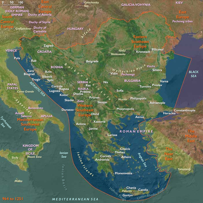
Barbarian tribes had begun to prey upon …
Years: 964 - 1107
Barbarian tribes had begun to prey upon the Roman Empire in the fourth century, and the fortunes of the Illyrian-populated lands had sagged.
The Germanic Goths and Asiatic Huns had been the first to arrive, invading in mid-century; the Avars had attacked in CE 570; and the Slavic Serbs and Croats had overrun Illyrian-populated areas in the early seventh century.
About fifty years later, the Bulgars had conquered much of the Balkan Peninsula and extended their domain to the lowlands of what is now central Albania.
Many Illyrians had fled from coastal areas to the mountains, exchanging a sedentary peasant existence for the itinerant life of the herdsman.
Other Illyrians had intermarried with the conquerors and eventually assimilated.
In general, the invaders had destroyed or weakened Roman and Byzantine cultural centers in the lands that would become Albania.
Again during the high medieval period, invaders ravage the Illyrian-inhabited regions of the Balkans.
Norman, Venetian, and Byzantine fleets attack by sea.
Bulgar, Serb, and Byzantine forces come overland and hold the region in their grip for years.
Clashes between rival clans and intrusions by the Serbs produce hardship that trigger an exodus from the region southward into Greece, including Thessaly, the Peloponnese, and the Aegean Is- lands.
The invaders assimilate much of the Illyrian population, but the Illyrians living in lands that comprise modern-day Albania and parts of Macedonia, Kosovo, Croatia, Slovenia, Serbia, and Greece are never completely absorbed or even controlled.
Locations
Groups
- Illyrians
- Greeks, Medieval (Byzantines)
- Bulgarians (South Slavs)
- Venice, Duchy of
- Macedonia, East Roman Theme of
- Serbs (South Slavs)
- Croats (South Slavs)
- Roman Empire, Eastern: Macedonian dynasty
- Dalmatia, Theme of
- Normans
- Albanians
- Roman Empire, Eastern: Non-dynastic and Comnenid dynasty
- Apulia, Norman Duchy of
- Roman Empire, Eastern: Doukid dynasty
- Apulia, Norman Duchy of
- Roman Empire, Eastern: Komnenos dynasty, restored
Subjects
Regions
Subregions
Related Events
Filter results
Showing 10 events out of 52798 total
We begin in the easternmost subregions and move westwardly around the globe, crossing the equator as many as six times to explore ever shorter time periods as we continue to circle the planet. The maps of the regions and subregions change to reflect the appropriate time period.
Narrow results by searching for a word or selecting from one or more of a dozen filters.
Northeast Eurasia (964 – 1107 CE): Liao Frontiers, Jurchen Leagues, and the Fur–Silver Networks of the Forests
Geographic and Environmental Context
Northeast Eurasia stretched from the Carpathian frontier of Kievan Rus’ and the Volga steppes through the West Siberian Plain, Amur–Heilongjiang basin, and Russian Far East to Hokkaidō and the Okhotsk coast.
This immense region linked the Eurasian forest and steppe worlds—taiga, tundra, and riverine plains—into a web of exchange reaching both the Byzantine–Islamic and East Asian empires.
Major river systems—Volga, Ob, Irtysh, Yenisei, Amur, and Dnieper—functioned as arteries of movement, while the Okhotsk Sea, Sakhalin–Hokkaidō corridor, and northern Pacific coasts sustained maritime hunting and limited trade.
Climate and Environmental Shifts
The Medieval Warm Period (c. 950–1250) slightly softened the subarctic climate.
-
Southern Siberia and the Amur basin saw longer growing seasons that permitted limited millet cultivation.
-
Forest-steppe margins expanded northward, improving grazing for Kyrgyz and Kipchak herds.
-
Salmon runs increased in the Amur and Okhotsk regions, while reduced ice along the Sea of Okhotsk opened new sea lanes.
These stable ecologies encouraged denser settlement in river valleys and intensified long-distance trade in furs, fish, and forest goods.
Societies and Political Developments
Kievan Rus’ and the Fall of Khazaria
In the southwest, Prince Sviatoslav of Kiev (r. 945–972) destroyed the Khazar Khaganate (964–969), ending centuries of steppe control over the Volga–Caspian gateway.
The victory transferred riverine hegemony to the Kievan Rus’, who dominated the Dnieper trade route to Byzantium and extended tributary claims northward to Novgorod and eastward toward the Volga Bulgars.
Vladimir I (r. 980–1015) Christianized Rus’ in 988, aligning it with Byzantine Orthodoxy; his son Yaroslav the Wise (r. 1019–1054) codified law and patronized cathedrals.
By the 11th century, Rus’ had become a federation of princely centers—Kiev, Novgorod, Smolensk, Chernigov—linked by rivers and fortified towns.
To the east, Volga Bulgars, Islamized in 922, prospered as intermediaries in the fur and silver trade, replacing Khazaria as the Islamic world’s northern supplier.
The Steppe and Taiga Frontiers
Beyond the settled Slavic–Finnic belt stretched the forest–steppe mosaics of Siberia.
The Yenisei Kyrgyz, heirs to the Uyghurs, maintained a khaganate in the Minusinsk Basin, collecting tribute from taiga hunters.
To their west, Kipchak confederations rose after the decline of the Kimeks, expanding along the Ishim–Irtysh corridor and absorbing Turkic groups.
By 1107 they dominated the western Siberian steppe, pressing Oghuz tribes westward toward Khwarazm and the Caspian, while coexisting with forest Ob-Ugric and Samoyedic hunters farther north.
The Forest and Riverine Peoples
Across the taiga, Ob-Ugric (Khanty, Mansi), Selkup, Ket, Nenets, and Evenki clans maintained kin-based communities centered on fishing, trapping, and reindeer herding.
Shamanic leadership coordinated seasonal migration and exchange.
To the east, Amuric-speaking Nivkh, Ulch, and Nanai (Hezhe) prospered on salmon harvests and seal hunts, sending tribute furs and falcons south to the Khitan Liao Empire (907–1125).
The Liao integrated the Amur tributaries into a regulated frontier system without annexation, trading iron and silk for pelts and ginseng.
The Rise of the Jurchen and Liao Frontiers
Among the Mohe descendants in the upper Amur, Jurchen tribal leagues formed by the 11th century, uniting millet farmers, hunters, and horsemen under chieftains who acknowledged, yet defied, Liao authority.
These confederations would later generate the Jin dynasty (1115–1234).
Further south, Song China traded indirectly through Liao markets, absorbing furs and ginseng from these northern intermediaries.
The Pacific Fringe and Hokkaidō
Along the Okhotsk coast, Koryak, Itelmen, and Chukchi sustained sea-mammal hunting and reindeer nomadism, bartering ivory and hides westward.
On Hokkaidō, the waning Okhotsk culture merged with the Satsumon tradition, producing a distinct Ainuethnogenesis—combining fishing, deer hunting, and millet farming.
By the late 11th century, the Ainu occupied northern Hokkaidō, trading dried salmon and hides to Honshū in exchange for iron tools and rice from Japanese merchants across the Tsugaru Strait.
Economy and Trade
Northeast Eurasia’s economy was anchored in furs, fish, forest goods, and silver.
-
Exports: sable, ermine, fox, beaver, walrus ivory, eagle feathers, and slaves.
-
Imports: iron, textiles, beads, salt, and grain from Liao, Khwarazm, and Rus’.
-
Dirham silver from the Samanids dominated early trade via Volga Bulgars and Khwarazm, but its decline after c. 970 forced northern merchants into hack-silver and barter economies.
-
By the 11th century, Byzantine coins, Rus’ bullion, and Liao silk replaced Islamic silver as the region’s exchange media.
Key entrepôts included Kiev, Khwarazm, Novgorod, Yeniseisk, and Amur tributary posts.
In the far northeast, Hokkaidō and Sakhalin exchanged furs and dried fish with Japan, while Okhotsk–Kamchatka trade linked sea hunters to inland reindeer peoples.
Subsistence and Technology
Riverine and forest technologies sustained high productivity:
-
Fisheries: wicker traps, bone-tipped harpoons, and drying racks for salmon and sturgeon.
-
Reindeer and sled economies among Evenki and Nenets facilitated winter transport.
-
Boats and sledges moved furs along the Ob, Irtysh, and Amur; dog teams linked Arctic settlements.
-
Agriculture: limited millet in southern Amur and northern Hokkaidō; plow farming in Rus’ and Volga Bulgar fields expanded rapidly.
-
Metals: iron from Liao and Rus’ artisans diffused east; copper kettles, bronze ornaments, and silver dirhams functioned as prestige goods.
-
Architecture: from timber fortresses and cathedrals in Kiev to semi-subterranean huts and reindeer tents in Siberia and the Amur valley.
Movement and Interaction Corridors
-
Dnieper–Black Sea route (“Road to the Greeks”) carried Rus’ and Byzantine commerce.
-
Volga–Kama–Caspian route sustained Islamic markets via Volga Bulgars.
-
Ob–Irtysh–Khwarazm corridor linked Siberian furs to Transoxiana.
-
Yenisei–Sayan passes transmitted Kyrgyz tribute to Inner Asia.
-
Amur River connected taiga villages to Liao markets.
-
Coastal Okhotsk routes united Sakhalin, Kamchatka, and Hokkaidō.
-
Tsugaru Strait and Sea of Japan channels tied the Ainu north and Japanese south into reciprocal exchange.
Belief and Symbolism
Religion and ritual across Northeast Eurasia reflected the interaction of shamanic cosmology, Tengri sky cults, Orthodox Christianity, Islam, and Buddhism.
-
Forest and Arctic peoples venerated sky, river, and animal spirits; shamans mediated through trance and drum.
-
Kyrgyz and Kipchaks upheld Tengri rites and horse burials while absorbing Islamic influences via Khwarazm.
-
Rus’ adopted Orthodox Christianity (988), replacing pagan temples with cathedrals and monasteries.
-
Volga Bulgars institutionalized Islamic law, blending steppe and mercantile traditions.
-
Amur peoples honored river and salmon spirits, while Ainu bear rituals (iyomante) expressed reciprocity with animal deities.
-
Koryak and Chukchi mythologies revolved around whale and reindeer gods, binding subsistence to cosmology.
Adaptation and Resilience
Ecological and political flexibility ensured survival in the region’s extremes:
-
Diversified subsistence (fish, fur, millet, and reindeer) buffered environmental risk.
-
Seasonal mobility along rivers and ice routes enabled resource sharing and trade.
-
Hybrid economies combined local foraging with tribute or barter ties to Rus’, Liao, and Islamic markets.
-
Cultural fusion—Ainu blending of Okhotsk and Satsumon; Jurchen synthesis of forest and agrarian lifeways—created enduring adaptive identities.
-
Religious pluralism allowed coexistence between new and traditional cosmologies.
Long-Term Significance
By 1107 CE, Northeast Eurasia had become a connected frontier zone—ecologically marginal yet economically indispensable to both continental empires and maritime exchange:
-
Kievan Rus’ matured as a Christian commonwealth balancing Byzantine and steppe influences.
-
Volga Bulgars dominated Islamic northern trade.
-
Kipchaks and Kyrgyz shaped the steppe balance, linking taiga furs to southern silver.
-
Amuric and Tungusic societies joined Liao tributary networks while remaining autonomous.
-
Jurchen tribal leagues emerged, poised to build the Jin Empire.
-
Ainu identity crystallized in Hokkaidō, maintaining cultural resilience against later Japanese encroachment.
Across this vast arc—from the Dnieper to the Okhotsk—rivers, forests, and steppes formed a single northern system of exchange that sustained Eurasian commerce, belief, and adaptation for centuries to come.
Northeast Asia (964 – 1107 CE): Liao Expansion, Ainu Consolidation, and Amuric–Tungusic Networks
Geographic and Environmental Context
Northeast Asia includes Siberia east of the Lena River basin to the Pacific Ocean, the Russian Far East (excluding southern Primorsky Krai/Vladivostok), the island of Hokkaidō above its southwestern peninsula, and China’s extreme northeastern Heilongjiang Province.
-
A cold-temperate and subarctic realm: taiga forests of larch and pine, salmon-rich rivers (Amur, Ussuri), sea-ice coasts along the Okhotsk, and volcanic uplands in Kamchatka.
-
Populations were dispersed, organized around riverine fisheries, coastal sea-mammal hunting, reindeer herding, and forest foraging, with exchange linking them southward into the orbit of larger continental states.
Climate and Environmental Shifts
-
The Medieval Warm Period (c. 950–1250 CE) brought slightly milder conditions, lengthening growing seasons along the Amur and southern Hokkaidō, allowing limited millet cultivation.
-
More abundant salmon runs and stable forest ecologies supported higher populations in the river valleys.
-
Reduced sea ice in some coastal years eased Okhotsk Sea navigation, intensifying maritime exchange.
Societies and Political Developments
Amur–Heilongjiang Basin
-
Nivkh, Ulch, Nanai (Hezhe), and related Amuric-speaking peoples thrived along the lower Amur and Ussuri.
-
Organized in clan-based villages, they coordinated salmon harvests and seal hunts while sending tribute furs, ginseng, and falcons southward to the Khitan Liao Empire (907–1125).
-
The Liao incorporated Amur tributaries into their frontier system, formalizing exchange while avoiding direct conquest.
-
Mohe groups, ancestral to the Jurchen, practiced slash-and-burn millet farming, pig raising, and hunting. By the 11th century they consolidated into Jurchen tribal leagues that would later birth the Jin dynasty (1115–1234).
Siberian Taiga and Tundra Peoples
-
Evenki and Even (Tungusic reindeer herders) expanded their ranges across interior taiga, balancing fur trapping with semi-domesticated reindeer economies.
-
Koryak and Itelmen in Kamchatka specialized in salmon fishing and sea-mammal hunts.
-
Chukchi herders on the northeast peninsula strengthened reindeer nomadism, with clan councils and ritual leaders holding authority.
-
These groups remained autonomous, but participated in fur–ivory trade with Amur peoples and indirectly with Liao brokers.
Hokkaidō
-
The Okhotsk culture waned during this age, gradually absorbed by the Satsumon culture (Ainu ancestors).
-
Ainu ethnogenesis accelerated: blending Okhotsk maritime lifeways with Satsumon agriculture (millet, barley), deer hunting, and salmon fishing.
-
By the late 11th century, distinct Ainu identity crystallized in northern Hokkaidō, while the southwest remained contested with Wajin (Japanese) settlers from Honshū.
Economy and Trade
-
Furs (sable, fox, ermine), seal and whale products, walrus ivory, and falcons flowed down the Amur to Liao markets, entering China and Central Asia.
-
Ginseng and medicinal herbs from Heilongjiang became prized commodities.
-
Ainu exported dried salmon, eagle feathers, and deer hides across the Tsugaru Strait to Honshū, receiving iron tools, lacquerware, and rice in exchange.
-
Chukchi and Koryak traded walrus ivory and seal skins westward through taiga intermediaries.
Subsistence and Technology
-
Riverine technologies: wicker traps, weirs, and drying racks for salmon.
-
Maritime hunting gear: toggling harpoons, skin-covered boats, and bone-tipped lances.
-
Taiga mobility: skis, snowshoes, dog sleds, and reindeer transport.
-
Agriculture: limited millet and barley in southern Amur and northern Hokkaidō, supplementing foraging.
-
Iron tools and weapons entered steadily via Liao and Japanese traders, but bone, stone, and antler remained essential.
Movement and Interaction Corridors
-
Amur River system: main artery linking forest hunters, fishing villages, and Liao tributary centers.
-
Coastal Okhotsk routes: connected Sakhalin, Kamchatka, and Hokkaidō, sustaining Okhotsk–Ainu cultural blending.
-
Tsugaru Strait: bridge between Hokkaidō Ainu and Japanese traders in northern Honshū.
-
Over-ice travel in winter enabled seasonal fairs along frozen rivers and bays.
Belief and Symbolism
-
Amur peoples venerated river and salmon spirits, with shamans conducting rituals at seasonal fishing sites.
-
Tungusic groups maintained sky and fire cults; shamans mediated clan life and hunting luck.
-
Ainu developed distinctive bear rituals (iyomante), expressing reciprocity with powerful animal spirits.
-
Koryak and Chukchi mythologies centered on whale and reindeer deities, binding subsistence to cosmology.
-
Burial rites often included hunting gear, animal bones, and antler regalia, signifying continued bonds with prey animals.
Adaptation and Resilience
-
Diversified economies (fish, game, limited cultivation) buffered climate swings.
-
Seasonal mobility ensured access to salmon, reindeer, and seals, reducing overdependence on one resource.
-
Trade alliances with Liao and Japanese polities allowed steady access to iron, grain, and prestige goods, while maintaining autonomy.
-
Ainu consolidation in Hokkaidō created cultural resilience, blending Okhotsk maritime and Satsumon agrarian elements.
Long-Term Significance
By 1107 CE, Northeast Asia had become a critical fur and frontier zone, woven into wider Eurasian systems through the Liao Empire and Japanese trade:
-
Amur peoples integrated into tributary networks while preserving autonomy.
-
Jurchen tribal leagues began to coalesce, foreshadowing their rise as a great power in the next century.
-
Ainu identity crystallized in Hokkaidō, sustaining distinct cultural lifeways into later centuries.
-
Siberian taiga and tundra groups endured with their resilient multi-resource economies, forming the ecological foundation for later contacts with Mongols, Chinese, and eventually Russians.
Northeast Asia in this age remained a frontier of forest, sea, and ice, simultaneously peripheral and indispensable to the great empires of Inner Asia and East Asia.
Northern North America (964 – 1107 CE): Salmon States, Mound Metropolises, and Desert Irrigators
Geographic and Environmental Context
Northern North America stretched from the Gulf of Alaska and Haida Gwaii down the Salish Sea and Pacific coast to California, eastward across the Great Basin and Puebloan Southwest to the Mississippi–Ohio valleys, the Great Lakes–St. Lawrence corridor, and the Atlantic seaboard—and north to Greenland and the Canadian Arctic.
It encompassed:
-
Northwest Coast and Subarctic/Arctic: Tlingit, Haida, Tsimshian, Kwakwakaʼwakw, Coast Salish; Dene (Athabaskan) interiors; Yup’ik and Inupiat Inuit; Unangan (Aleut) and Sugpiaq/Alutiiq.
-
Northeast: Norse Greenland and Vinland outposts; Mississippian and Woodland centers from the St. Lawrence–Great Lakes to the Tallgrass Prairie; Iroquoian and Algonquian village belts; Old South/Appalachian chiefdoms; Thule expansion across the Arctic.
-
Gulf & Western: Lower Mississippi, Cahokia’s wider sphere, Spiro, Etowah, Moundville; Chaco Canyon roads and great houses; Hohokam irrigation in the Sonoran; Mogollon–Sinagua towns; Chumash littoral polities; Great Basin foragers.
Climate and Environmental Shifts
The Medieval Warm Period (c. 950–1250) stabilized and in places lengthened growing and navigation seasons.
-
Northwest Coast: heavy rainfall sustained massive cedar forests; salmon runs were reliable.
-
Subarctic/Arctic: slightly longer ice-free windows increased whaling opportunities, though sea-ice variability remained high.
-
Mississippi–Ohio valleys: warmth supported the maize boom and urbanization at Cahokia (c. 1050 onset).
-
Colorado Plateau/Sonoran: Chaco (1050–1130 zenith) flourished within favorable precipitation patterns; Hohokam irrigation buffered aridity.
-
California: oak savannas and coastal fisheries remained highly productive.
Societies and Political Developments
North Pacific Coast & Arctic
Stratified house-group chiefdoms on the coast managed ranked lineages, fishing/whaling grounds, and winter villages; potlatch intensified as theatrical redistribution of wealth and rights. Dene bands coordinated caribou/salmon circuits between taiga and rivers. Inuit developed large communal whale hunts and winter qasgiq ceremonial houses; Unangan and Sugpiaq organized maritime village clusters with leadership rooted in hunting prowess and boat building.
Northeast & Interior Woodlands
Norse Greenland stabilized farming and walrus-ivory exports; Vinland (Newfoundland) saw short-lived Norse ventures and conflict with local peoples. Cahokia emerged as a mound-metropolis with elite compounds, plazas, and woodhenges marking ritual calendars; Old South/Appalachian chiefdoms raised platform mounds. Iroquoianlonghouse communities and Algonquian riverine villages densified across the Great Lakes and St. Lawrence. On the tundra, Thule Inuit expanded eastward, replacing Dorset traditions.
Gulf & Western
Mississippian chiefdoms (Etowah, Moundville, Spiro) elaborated the Southeastern Ceremonial Complex; Spiro in the Arkansas Valley grew as a ritual–trade hub. In the Southwest, Chaco orchestrated a network of great houses, roads, and kivas; Hohokam enlarged canal systems and cotton/crop production; Mogollon–Sinagua towns persisted as mixed-farming communities. Along the Channel coast, Chumash intensified a bead-currency maritime economy; Great Basin societies deepened pinyon and exchange lifeways.
Economy and Trade
-
Coast & Arctic: salmon surpluses (dried/smoked) underwrote population and ceremony; eulachon (oolichan) oil traveled inland along Grease Trails; native copper from Yukon/interior circulated as ingots and hammered regalia; dentalium shells moved north from California; ivory, baleen, and marine oils flowed through Dene and coastal brokers.
-
Mississippian & Woodlands: maize redistribution centered on Cahokia; exchange of copper, shell gorgets, chert, ceremonial pipes; Great Lakes/Atlantic fisheries supported dense coastal and riverine communities. Greenland Norse exported walrus ivory to Europe.
-
Southwest & California: Chaco networks trafficked turquoise, obsidian, macaws; Hohokam moved cotton, shell jewelry, and irrigation produce; Chumash circulated shell-bead currency, tying Pacific routes to interior markets; Great Basin moved salt and obsidian into Pueblo worlds.
Subsistence and Technology
-
Northwest Coast: monumental cedar plank houses, crest poles, and raised granaries; large red-cedar dugout canoes for freight, warfare, and ceremony; smokehouses and oil-rendering vats for preservation.
-
Arctic: qayaq and umiak, toggling harpoons, composite bows; sophisticated sea-ice knowledge.
-
Dene & Interior: sinew-backed bows, birchbark canoes, snowshoes, toboggans; flexible river–taiga scheduling.
-
Mississippi–Woodlands: earthwork engineering (platform mounds, causeways), woodhenges as calendrical devices, diversified maize–bean–squash regimes.
-
Southwest: multistory great houses, road alignments, and kiva architecture at Chaco; canal engineering and cotton textiles among Hohokam.
-
California: plank canoes (tomols) in the south, advanced fish weirs and acorn-processing economies; formalized bead production.
Movement and Interaction Corridors
-
Inside Passage knit Haida Gwaii–Tlingit fjords–Kwakwakaʼwakw sounds–Salish inlets; Yukon and Copper Rivers linked Dene to coastal fairs.
-
Grease Trails carried oolichan oil, furs, obsidian coast⇄plateau.
-
Bering Strait enabled Inuit–Chukchi trans-Arctic ties.
-
St. Lawrence–Great Lakes funneled goods between interior and Atlantic; Ohio–Mississippi corridors radiated from Cahokia.
-
Chaco roads connected canyon centers to outliers; Hohokam canals concentrated production and exchange.
-
Pacific littoral linked Chumash and northern neighbors via shell currency and canoe voyaging.
Belief and Symbolism
-
Northwest Coast: clan crests (Raven, Eagle, Killer Whale, Wolf) encoded lineage titles and narrative rights; potlatch dramatized myth cycles and law.
-
Arctic: whale/seal rituals honored prey spirits; qasgiq dances renewed communal bonds.
-
Dene: shamanic guardians, vision quests, and narrative law aligned subsistence with morality.
-
Mississippian: the Southeastern Ceremonial Complex (birdman, serpent) expressed elite cosmology; Cahokia’s mounds and woodhenges synchronized ritual and polity.
-
Southwest: kiva ceremonialism ordered time, space, and society; macaw/turquoise regalia symbolized distant connections.
-
California littoral: Chumash cosmology elevated canoe chiefs as celestial navigators within a star-mapped sea.
Adaptation and Resilience
-
Ecological scheduling: sequential harvests (salmon→eulachon→berries/deer; maize→nuts/fish; pinyon→game) spread risk.
-
Preservation technologies (smoking, drying, oil rendering) created buffers against shortfalls.
-
Redundant corridors—river, coastal, and road networks—re-routed flows during conflict or climate swings.
-
Ceremonial redistribution (potlatch, mound-center feasts, kiva rites) translated surplus into social stability and intergroup diplomacy.
-
Water/land engineering (Hohokam canals, Chaco roadworks, fish weirs) extended carrying capacity.
Long-Term Significance
By 1107 CE, Northern North America sustained three synergistic civilizational zones:
-
A salmon-and-cedar coast of ranked chiefdoms and potlatch law, integrated with Dene interiors and Inuit Arctic whaling.
-
A mound-metropolis heartland centered on Cahokia, radiating ceremonial, economic, and political influence across the Mississippi and Old South.
-
A desert–littoral innovation belt where Chaco ritual economies, Hohokam irrigation cities, and Chumash sea commerce tied the interior to the Pacific.
Norse Greenland and brief Vinland contacts bookended the Atlantic frontier, while cross-continental exchange in copper, shells, oil, ivory, turquoise, and maize linked forests, plains, deserts, and seas. The balance of ritual prestige, ecological scheduling, and engineered landscapes laid a durable foundation for the monumental art, intensified warfare, and widening trade spheres of the 12th–13th centuries.
Northwestern North America (964 – 1107 CE): Salmon Surpluses, Potlatch Prestige, and Arctic Adaptations
Geographic and Environmental Context
Northwestern North America includes western Canada (the Yukon and British Columbia), Alaska, Washington, northern Idaho, and the northwestern portions of Montana, Oregon, and California.
-
The Pacific littoral (from the Gulf of Alaska to the Salish Sea) supported dense coastal societies, while the interior plateaus and taiga–tundra zones hosted mobile Dene hunters and salmon fishers.
-
The Bering Strait–Chukchi–Beaufort seas framed Inuit marine hunting worlds, linked east–west across Arctic waters.
Climate and Environmental Shifts
-
The Medieval Warm Period (c. 950–1250 CE) slightly lengthened ice-free seasons, stabilizing salmon runs and improving caribou pasture in the subarctic.
-
On the coast, heavy rainfall sustained massive cedar forests; inland, warming cycles enhanced growing conditions in valley bottoms.
-
In the Arctic, reduced but variable sea ice expanded whaling opportunities while exposing hunters to greater climatic swings.
Societies and Political Developments
-
North Pacific Coast chiefdoms (Tlingit, Haida, Tsimshian, Kwakwakaʼwakw, Coast Salish):
-
Stratified lineages (house-groups) managed winter villages, ceremonial orders, and exclusive fishing/whaling grounds.
-
Potlatch feasts escalated in scale, redistributing surpluses (blankets, oil, carved regalia) and consolidating hereditary prestige.
-
-
Aleut (Unangan) and Sugpiaq/Alutiiq organized into maritime village clusters in the Aleutians and Kodiak; leadership rested with expert hunters and boat-builders.
-
Athabaskan (Dene) interior bands (Gwich’in, Carrier, Tahltan, Kaska) balanced caribou hunting with salmon fishing, shifting seasonally between riverine and taiga landscapes.
-
Yup’ik and Inupiat Inuit extended across western and northern Alaska, coordinating large communal whale hunts (bowhead, gray) and winter ceremonial houses (qasgiq).
Economy and Trade
-
Salmon surpluses (dried/smoked) fueled population growth and ceremonial distribution on the coast.
-
Eulachon (oolichan) oil pressed from spring runs became a trade staple, carried inland as “grease trails” linking coastal and plateau peoples.
-
Native copper from the upper Yukon and Alaska interior entered prestige economies, traded as ingots or hammered ornaments.
-
Dentalium shells from coastal California circulated north into Salish and Haida territories as wealth symbols.
-
Arctic ivory, baleen, and oil passed inland through Dene and coastal brokers.
Subsistence and Technology
-
Cedar architecture: monumental plank houses, totemic crest poles, and storage platforms characterized coastal villages.
-
Canoe technology: large red cedar dugouts carried freight and raiding parties across the Inside Passage.
-
Arctic craft: qayaq (kayaks) for single hunters; umiak (skinboats) for groups; toggling harpoons and composite bows for sea-mammal hunting.
-
Inland tools: sinew-backed bows, birchbark canoes, snowshoes, and toboggans sustained Dene mobility.
-
Food processing: smokehouses, oil-rendering vats, and stone-lined roasting pits extended shelf-life of key resources.
Movement and Interaction Corridors
-
The Inside Passage remained a cultural highway, with canoe voyages linking Haida Gwaii, Tlingit fjords, Kwakwakaʼwakw sounds, and Salish inlets.
-
Grease Trails carried oolichan oil, furs, and obsidian from coast to plateau.
-
The Yukon and Copper Rivers tied Dene hunters to coastal trade fairs.
-
Bering Strait crossings connected Inuit and Chukchi hunters in trans-Arctic exchange networks.
Belief and Symbolism
-
Coast: clan crests (Raven, Eagle, Killer Whale, Wolf) embodied social contracts; potlatch ceremonies dramatized myth cycles and lineage rights.
-
Arctic: whale and seal rituals honored prey spirits, ensuring their return; winter qasgiq dances renewed communal ties.
-
Interior Dene: shamanic vision quests, animal-spirit guardians, and storytelling tied subsistence calendars to moral landscapes.
-
Material culture—copper shields, carved masks, feathered regalia—embodied the spiritual charge of wealth and social rank.
Adaptation and Resilience
-
Resource scheduling: sequential harvests of salmon, eulachon, sea mammals, deer, and caribou spread ecological risk.
-
Preservation technologies (smoking, drying, oil rendering) buffered against seasonal shortfalls.
-
Interregional exchange redistributed prestige goods and staples, insulating local communities from collapse.
-
Ceremonial redistribution in potlatches converted surplus into social capital, stabilizing inequalities through spectacle.
Long-Term Significance
By 1107 CE, Northwestern North America sustained a flourishing coastal chiefdom complex alongside highly adaptive subarctic and Arctic economies. The coast was defined by salmon surpluses and potlatch politics; the interior and Arctic by Dene–Inuit resilience and cross-ecological trade. The region’s balance of ritual prestige, ecological scheduling, and exchange corridors created a stable foundation for later monumental art traditions, intensified warfare, and the expansive trade spheres of the high medieval centuries.
Polynesia (964 – 1107 CE): Voyaging Renewals and Island States
Geographic and Environmental Context
Polynesia, spanning the vast Pacific triangle from Hawaiʻi to Tonga and Rapa Nui, entered a period of dynamic cultural and environmental maturity during the Lower High Medieval Age.
The region’s three principal spheres—North Polynesia, West Polynesia, and East Polynesia—were linked by voyaging routes that fostered sustained contact, ritual exchange, and technological renewal.
High volcanic islands such as Oʻahu, Tonga, and Ra‘iātea supported intensive irrigation and monumental construction, while low coral atolls like Tokelau and Tuvalu relied on arboriculture and reef fisheries.
At the eastern fringe, new island groups—Rapa Nui and the Pitcairn–Henderson cluster—entered the Polynesian network through pioneering settlement voyages.
Climate and Environmental Shifts
The Medieval Warm Period (c. 950–1250 CE) brought stable, slightly warmer temperatures across the tropical Pacific.
Rainfall patterns favored high-island agriculture but remained uneven on atolls, where prolonged droughts required redistribution of food and water via inter-island exchange.
Reliable wind patterns and calmer seas extended navigable seasons, reinforcing the cultural renaissance of long-distance voyaging and ritual integration.
Societies and Political Developments
Across the Polynesian world, social hierarchies consolidated around chiefly lineages, priestly authority, and ritual centers.
-
In North Polynesia, aliʻi nui coordinated ridge-to-reef resource systems that evolved into proto-ahupuaʻa, uniting agricultural valleys, upland forests, and reef fisheries under coherent management.
-
In West Polynesia, the Tuʻi Tonga dynasty established the first transoceanic polity, extending influence through Samoa, Fiji, and the Cook Islands, while Taputapuātea marae on Ra‘iātea became a sacred pan-Polynesian nexus.
-
Samoan councils maintained equilibrium through federated chiefdoms and oratory, contrasting with Tongan centralization yet remaining pivotal to regional diplomacy.
-
In East Polynesia, the colonization of Rapa Nui marked the outermost expansion of Polynesian civilization, while the Pitcairn–Henderson–Mangareva triangle sustained a specialized exchange economy.
Economy and Trade
Intensified agriculture underpinned demographic growth:
-
Irrigation systems expanded, particularly the loʻi kalo terraces of Hawaiʻi and the yam and taro pondfields of Tonga and Samoa.
-
Fishponds (loko iʻa) reached new scale and sophistication, converting nearshore lagoons into managed aquaculture zones.
-
High-island surpluses—dried fish, breadfruit paste, and preserved meats—were exchanged with atoll communities for mats, shells, and canoe timber.
-
Prestige goods—fine mats (ʻie tōga), basalt adzes, barkcloth, and feather regalia—circulated widely through ritual tribute and marriage alliances.
These networks sustained both subsistence and symbolic economies, binding distant archipelagos into a shared maritime system.
Belief and Symbolism
Polynesian cosmologies reached new coherence through institutionalized ritual centers:
-
Heiau and marae served as nodes linking divine ancestry, agricultural fertility, and chiefly legitimacy.
-
The Taputapuātea cult articulated a theology of shared descent and sacred voyaging, enshrining Ra‘iātea as the “navel of the world.”
-
Tongan divine kingship manifested in monumental langi tombs, while Samoan ritual oratory and fine-mat exchanges sanctified social harmony.
-
On Rapa Nui, early ahu platforms signified ancestral veneration and the first expressions of a monumental stone tradition that would later define the island.
Adaptation and Resilience
Polynesian societies combined technological ingenuity with ecological foresight:
-
Distributed production across terraced valleys, coastal fishponds, and reef zones buffered against drought and storm.
-
Communal labor cycles maintained irrigation and aquaculture systems, ensuring continuity of food security.
-
Inter-island reciprocity provided redundancy; famine or cyclone losses on one island could be offset through ceremonial redistribution.
-
Ritual calendars coordinated agricultural and fishing seasons, while the kapu system protected spawning grounds and sacred forests.
Long-Term Significance
By 1107 CE, Polynesia exhibited one of the most integrated oceanic civilizations on Earth:
-
North Polynesia developed complex, ecologically integrated ahupuaʻa systems.
-
West Polynesia achieved both political and ritual unity through the Tuʻi Tonga dynasty and the Taputapuātea cult.
-
East Polynesia witnessed the final wave of human settlement, extending the Polynesian world to its easternmost frontier.
These developments laid the institutional, technological, and cosmological foundations for the grand Polynesian expansions and state formations of the subsequent centuries.
North Polynesia (964 – 1107 CE): Ahupuaʻa Landscapes, Loko Iʻa Expansion, and Chiefly Consolidation
Geographic and Environmental Context
North Polynesia includes Oʻahu, Maui, Kauaʻi, Molokaʻi, Lānaʻi, Niʻihau, and Midway Atoll (episodic).
-
Mature agricultural basins and protected leeward coasts supported population growth; reef flats and embayments were engineered into extensive fishpond systems.
Climate and Environmental Shifts
-
Generally favorable rainfall; episodic droughts required flexible scheduling in dryland fields and heavier reliance on fishpond output and preserved foods.
Societies and Political Developments
-
Greater chiefly centralization under aliʻi nui on Oʻahu, Maui, and Kauaʻi.
-
Land–water administration crystallized into ridge-to-reef management akin to ahupuaʻa (not necessarily codified yet, but practiced): coordinated streams, terraces, fallows, and nearshore fisheries.
-
Ritual leadership intensified, with heiau networks legitimizing chiefly claims and regulating seasonal closures.
Economy and Trade
-
Intensified irrigation: expansion and refurbishment of loʻi kalo terraces; diversification of dryland crops (ʻuala, gourds, sugarcane).
-
Fishponds (loko iʻa) proliferated—stone walls, sluice gates, and species management (ʻamaʻama, awa) scaled up protein production.
-
Interisland exchanges moved canoe hulls, basalt, salt, dried fish, dog and pig stocks, and barkcloth; specialist craft lineages (stoneworkers, canoe builders, net makers) gained prominence.
Subsistence and Technology
-
Sophisticated ditch gradients, terraced mosaics, and weir placement maximized flow and yields.
-
Fishpond engineering: sluice gates (mākāhā), stacked-stone revetments, scheduled harvest rotations.
-
Navigation refined—stellar paths, swell patterns, bird behavior—ensured consistent interisland voyaging.
Movement and Interaction Corridors
-
Canoe routes tied all high islands, with regular provisioning voyages and marriage alliances aligning districts.
-
Midway remained peripheral, occasionally tapped for seabirds and marine resources.
Belief and Symbolism
-
Temple complexes (heiau) dedicated to agriculture, fishing, healing, and war expanded; feather regalia (ʻahu ʻula, mahiole) symbolized rank.
-
The kapu system structured access to water heads, pond gates, and spawning grounds, embedding ecology in ritual law.
-
Genealogical recitations linked aliʻi authority to ancestral deities and sacred landscapes.
Adaptation and Resilience
-
Distributed production (valley terraces + coastal ponds + dryland fields + reef gleaning) created redundancy.
-
Communal labor cycles (ditch cleaning, wall repairs, pond harvests) maintained infrastructure resilience.
-
Interisland reciprocity and ritual closures protected stocks through shocks (drought, storms).
Long-Term Significance
By 1107 CE, North Polynesia possessed highly integrated ahupuaʻa-like systems, mature fishpond networks, and consolidated chiefly polities, providing the demographic and institutional base for later island-wide states and monumental temple construction.
West Polynesia (964 – 1107 CE): Tuʻi Tonga Hegemony, Samoan Councils, and the Rise of Taputapuātea
Geographic and Environmental Context
West Polynesia includes the Big Island of Hawaiʻi, Tonga, Samoa, Tuvalu, Tokelau, the Cook Islands, and French Polynesia (Society Islands and Marquesas).
-
High volcanic islands (Tonga, Samoa, Societies, Marquesas) provided fertile soils for intensive horticulture and supported monumental temple-building.
-
Atolls (Tokelau, Tuvalu, northern Cooks) remained resource-scarce, requiring arboriculture, reef fishing, and long-distance ties for resilience.
-
The Big Island of Hawaiʻi remained geographically peripheral but continued gradual population and chiefly consolidation.
Climate and Environmental Shifts
-
The Medieval Warm Period (c. 950–1250 CE) brought slightly warmer, more stable conditions in the Pacific, strengthening crop reliability and lengthening sailing seasons.
-
Cyclones still periodically disrupted atoll communities, but surplus redistribution through exchange networks cushioned impacts.
Societies and Political Developments
Tonga
-
The Tuʻi Tonga dynasty consolidated power, extending political and ritual authority beyond Tonga into Samoa, Fiji, and the Cook Islands.
-
Tonga’s expansion marked the first regional Polynesian thalassocracy, uniting island groups under dynastic marriage alliances, tribute systems, and shared ritual frameworks.
-
Large-scale earthworks and elite burials (langi tombs) symbolized dynastic power.
Samoa
-
Power remained distributed among extended kin-groups and councils of matai (chiefs).
-
Samoan institutions—lineage balance, oratory, fine mats (ʻie tōga) as ritual wealth—served as a cultural model for neighboring archipelagos.
-
While not politically unified like Tonga, Samoa wielded immense cultural influence through marriage, ritual exchange, and migration.
Society Islands
-
Taputapuātea marae on Ra‘iātea emerged as a pan-Polynesian ritual and political center, attracting chiefs and priests from across Polynesia to perform alliance-building rituals.
-
The marae created a sacred diplomatic network binding Societies, Cooks, Marquesas, and Tuamotus in shared cult practices.
Marquesas
-
Intensified chiefdom competition led to larger meʻae ceremonial sites and expanded artistic expression in tattooing, wood carving, and ritual stonework.
-
Chiefs legitimized power through alliances with Society Islands cult centers.
Cook Islands, Tokelau, Tuvalu
-
Smaller island chiefdoms incorporated into Tongan and Society networks through marriage and ritual ties.
-
Exchanges with Samoa remained crucial for survival on resource-scarce atolls.
Hawaiʻi (Big Island)
-
Hawaiian society continued gradual growth; irrigation of taro fields expanded in Kona and Hilo, and chiefly lineages gained strength.
-
Hawaiian polities were still localized compared to the hierarchical systems emerging further south.
Economy and Trade
-
Agriculture: intensification of irrigated taro and yam cultivation in high islands; breadfruit and coconut groves sustained atolls.
-
Animal husbandry: pigs, dogs, and chickens supported chiefly feasts and exchanges.
-
Maritime exchange networks: Tonga’s expansion and Taputapuātea’s ritual ties created a dual system of political and religious integration across West Polynesia.
-
Prestige goods: Samoan fine mats, Tongan barkcloth, Society Islands basalt adzes, and Marquesan carvings circulated widely.
Subsistence and Technology
-
Irrigated taro pondfields expanded in Samoa, Societies, and Hawaii.
-
Stone terracing and arboriculture enhanced soil productivity.
-
Fishponds and reef management systems advanced in Hawaii and Tonga.
-
Double-hulled voyaging canoes with crab-claw sails carried chiefs and priests to Taputapuātea and across the Tongan maritime empire.
-
Navigation relied on star compasses, ocean swells, bird routes, and oral transmission of sea-lore.
Movement and Interaction Corridors
-
The Tonga–Samoa–Fiji triangle served as the political-economic core of the Tuʻi Tonga network.
-
Taputapuātea marae integrated the Societies, Cooks, Marquesas, and Tuamotus into a ritual federation.
-
Marquesas–Societies voyages reinforced alliances and exchange.
-
Hawaiʻi remained marginal but increasingly tied into Polynesian exchange spheres through exploratory voyages.
Belief and Symbolism
-
Divine kingship (Tuʻi Tonga) emphasized sacred descent and cosmological order; langi tombs materialized chiefly power.
-
Taputapuātea marae became the religious axis of Polynesia, symbolizing shared gods, genealogies, and rituals.
-
Samoa’s fine mats functioned as sacred wealth in ritual exchanges, embodying ancestral mana.
-
Marquesan meʻae ritual sites anchored clan cosmologies.
Adaptation and Resilience
-
Diversified subsistence strategies (taro, yams, breadfruit, reef fish, arboriculture) reduced vulnerability to storms.
-
Redistributive rituals (potlatch-like feasting, fine mat exchanges, temple ceremonies) stabilized inequalities and alliances.
-
Voyaging networks linked atolls to high-island surpluses, preventing famine.
-
Cultural integration through marae cults and Tongan overlordship strengthened resilience against localized ecological disasters.
Long-Term Significance
By 1107 CE, West Polynesia stood as the political and religious center of Polynesia:
-
The Tuʻi Tonga dynasty extended real political influence across the western Pacific.
-
The Taputapuātea marae created a shared cultic network that gave ideological cohesion to the far-flung Polynesian world.
-
Samoan councils preserved balance and cultural prestige through oratory, kinship, and fine mats.
-
Together, these systems integrated West Polynesia into a maritime commonwealth that influenced all of Polynesia, anchoring later exploration and state formation in Hawaiʻi, Aotearoa, and Rapa Nui.
Micronesia (964 – 1107 CE): Navigators, Chiefdoms, and the Architecture of the Sea
Geographic and Environmental Context
Micronesia in the Lower High Medieval Age stretched across the western and central Pacific — from the Mariana Islands and Yap–Chuuk–Palau complex in the west to the Marshall Islands, Kiribati, Kosrae, and Nauru in the east.
This immense maritime realm spanned more than 7 million km² of ocean, linking high volcanic islands, limestone plateaus, and coral atolls into one of the world’s most intricately networked seascapes.
High islands such as Kosrae, Yap, Palau, and Chuuk offered freshwater, fertile valleys, and taro swamps, while the low atolls of the Marshalls and Kiribati relied on arboriculture, preserved breadfruit, and lagoon fishing.
Canoe routes — the region’s highways — carried tribute, marriage partners, and ritual obligations across hundreds of miles of open sea.
Climate and Environmental Shifts
The Medieval Warm Period (c. 950 – 1250 CE) brought relative climatic stability across Micronesia.
Steady trade winds and reliable rainfall favored arboriculture on high islands, while atolls remained exposed to the cycles of El Niño drought and La Niña storm.
Typhoons periodically stripped atoll groves, yet flexible voyaging networks and food-preservation technologies ensured regional resilience.
Kosrae’s fertile highlands and Yap’s well-watered valleys acted as ecological anchors, supplying atoll populations during shortages.
Societies and Political Developments
Across Micronesia, new forms of chiefly hierarchy, monumental architecture, and ritualized navigation emerged.
-
West Micronesia saw the rise of prestige-based systems that knit scattered islands into spheres of obligation and alliance.
-
On Yap, powerful chiefs coordinated the early sawei network — a system of reciprocal tribute linking outer atolls (Ulithi, Woleai, Lamotrek, Satawal) to the central island.
-
In the Marianas, the first latte-stone foundations appeared in the south, marking the houses of emerging chiefly lineages (maga’låhi).
-
Chuuk developed lagoon-centered chiefdoms, with fortified hill refuges and clan-based authority.
-
Palau formed councils of chiefs that regulated warfare and fertility rituals through monumental meeting houses (bai).
-
-
East Micronesia produced a parallel flowering of centralized leadership.
-
On Kosrae, the rise of a sacred kingship (tokosra) laid the foundations for the later monumental city of Lelu, symbolizing divine rule and architectural ambition.
-
In the Marshall Islands and Kiribati, atoll chiefdoms expanded, controlling land, lagoon tenure, and fishing rights through hereditary chieftainship.
-
Nauru sustained smaller clan federations that prized self-sufficiency while maintaining ritual and trade ties.
-
Together, these systems articulated a continuum from loosely federated atolls to nascent maritime kingdoms.
Economy and Trade
Micronesian economies balanced horticulture, arboriculture, and fishing within extensive exchange networks.
-
Staples: breadfruit, coconut, taro, yam, and pandanus supported both subsistence and ceremonial feasting.
-
Animal resources: reef fish, deep-sea tuna, turtles, and seabirds supplemented diets; pigs and chickens were scarce but symbolically significant.
-
Exchange circuits:
-
Yap ⇄ Outer Islands: preserved breadfruit paste, fiber mats, and shells moved inward; Yap exported canoe timber, turmeric, and prestige stones — the embryonic form of its later rai stone economy.
-
Kosrae ⇄ Marshalls/Kiribati: tribute and trade goods — canoes, mats, and shell ornaments — circulated along sea lanes radiating from Kosrae’s high island hub.
-
Palau ⇄ Yap ⇄ Philippines: regional contact zones carried ironwood, taro, and ceremonial items.
-
Marianas: pottery, fishhooks, and ornaments moved among northern and southern islands, strengthening kinship and ritual ties.
-
These exchanges bound together hundreds of communities into a resilient, inter-dependent maritime economy.
Subsistence and Technology
Micronesian subsistence rested on precise ecological management and technological ingenuity:
-
Agriculture and arboriculture: irrigated taro swamps in Palau and Yap; coconut and breadfruit groves on atolls; pandanus fiber for mats and sails.
-
Food preservation: fermented breadfruit pits (bwiro, ma) ensured multi-year reserves; smoked fish and dried pandanus paste sustained long voyages.
-
Canoe technology: double-hulled and outrigger craft with crab-claw sails allowed voyages of 500 km or more.
-
Navigation: wayfinders memorized star paths, currents, swells, and bird flights; in the Marshalls, stick chartsencoded oceanography as a tangible map of motion.
-
Architecture: early stone construction began at Kosrae, foreshadowing monumental urbanism; latte stones in the Marianas rose as durable symbols of lineage permanence.
Together these technologies represented a unique synthesis of practical engineering and cosmological expression.
Movement and Interaction Corridors
Micronesian navigation transformed the ocean into a lived landscape.
-
The sawei network radiated from Yap, binding the Caroline atolls through tribute and protection.
-
Chuuk Lagoon linked dozens of islets by daily canoe traffic, maintaining internal unity.
-
Palau extended voyaging toward Yap and western archipelagos.
-
In the east, Kosrae acted as a hub connecting the Carolines to the Marshalls and Kiribati.
-
The Marianas maintained north–south cohesion through regular voyages along their island chain.
Every voyage was simultaneously economic, political, and sacred — reaffirming kinship, redistributing wealth, and renewing cosmological order.
Belief and Symbolism
Micronesian spirituality bound ocean, ancestry, and navigation into a single sacred system.
-
On Kosrae, divine kingship fused governance with cosmic authority; shrines and tombs sanctified the ruler’s lineage.
-
On Yap, chiefs embodied mana, and stone shrines anchored prestige rituals.
-
Palauan fertility cults linked women’s authority to taro and lagoon abundance; bai meeting houses were carved with mythic histories.
-
Marianas’ latte stones symbolized ancestral endurance and legitimacy.
-
Throughout the region, canoes were consecrated as sacred beings — their keels blessed before launch, their voyages accompanied by chant and offering.
The sea itself was understood as a spiritual domain populated by ancestors and deities who guided wayfinders through dreams and omens.
Adaptation and Resilience
Micronesian societies perfected strategies for survival in fragile island ecologies:
-
Multi-island networks distributed risk across space — if one atoll suffered drought, others supplied aid.
-
Food preservation and arboricultural diversity guaranteed continuity through climatic swings.
-
Chiefly redistribution transformed political authority into ecological stewardship, ensuring equitable sharing of scarce resources.
-
Navigation schools safeguarded knowledge transmission, maintaining cultural and environmental literacy across generations.
These adaptive systems turned geographic isolation into a source of strength.
Long-Term Significance
By 1107 CE, Micronesia had matured into a maritime commonwealth of atoll chiefdoms and high-island centersbound by navigation, exchange, and ritual.
-
Yap presided over the western tribute network that foreshadowed the full sawei system.
-
Kosrae emerged as the eastern keystone of political and architectural innovation, anticipating the monumental complex of Lelu.
-
Palau, Chuuk, and the Marianas consolidated hierarchical chiefdoms defined by ritual architecture and clan councils.
-
Across the entire region, mastery of wayfinding and resource management created one of the most sophisticated non-literate navigational civilizations in world history.
Micronesia thus entered the twelfth century as a sea of connected sovereignties — its people unified not by land, but by the ocean paths that carried memory, exchange, and sacred order from horizon to horizon.
East Micronesia (964 – 1107 CE): Monumental Beginnings, Navigational Mastery, and Expanding Chiefdoms
Geographic and Environmental Context
East Micronesia includes Kiribati, the Marshall Islands, Nauru, and Kosrae.
-
The Marshall and Kiribati atolls depended on lagoon fishing, coconut cultivation, and reef resources.
-
Kosrae, as a high island, offered agricultural abundance and freshwater, serving as the regional political center.
-
Nauru remained small and self-sufficient, oriented toward fishing and small-scale horticulture.
Climate and Environmental Shifts
-
The Medieval Warm Period stabilized rainfall across much of the Pacific, though atolls remained vulnerable to El Niño drought cycles.
-
Cyclones posed recurring threats, mitigated by inter-island exchange.
-
Fertile Kosrae buffered food shortages for surrounding islands.
Societies and Political Developments
-
Kosrae saw the rise of a powerful sacred kingship (tokosra), consolidating authority and laying the foundations for the later monumental city of Lelu.
-
Atoll chiefdoms in the Marshall Islands and Kiribati expanded, with chiefs regulating land tenure, fishing, and ritual redistribution.
-
Nauru maintained smaller, clan-based communities with flexible leadership.
-
Regional cohesion was reinforced by inter-island voyaging, marriage alliances, and ceremonial exchanges.
Economy and Trade
-
Breadfruit, taro, pandanus, and coconuts formed horticultural staples.
-
Fishing and sea foraging remained central, with preserved surpluses sustaining populations.
-
Inter-island exchange moved canoes, mats, preserved breadfruit, shell valuables, and ritual goods.
-
Kosrae’s emerging political centrality attracted tribute and cemented its role as an island hub.
Subsistence and Technology
-
Outrigger and double-hulled canoes supported long-range voyaging and trade.
-
Navigation mastery deepened, with Marshallese stick charts encoding swells and currents.
-
Early stone construction began at Kosrae, foreshadowing Lelu’s monumental architecture.
-
Breadfruit preservation pits allowed food to be stored for years, a vital adaptation.
Movement and Interaction Corridors
-
The Marshall Islands and Kiribati developed extensive voyaging networks, linking scattered atolls.
-
Kosrae became a major node, drawing in exchange from the wider Caroline and Micronesian worlds.
-
Nauru maintained looser ties but still participated in ritualized exchanges.
-
Regional mobility ensured resilience and reinforced cultural unity.
Belief and Symbolism
-
Sacred kingship on Kosrae intertwined political and divine authority.
-
Atoll societies emphasized ancestral spirits, ocean deities, and navigation rituals.
-
Canoes were sacred vessels, imbued with mana, their construction accompanied by ritual.
-
Shrines and ritual sites on Kosrae reflected growing social stratification.
Adaptation and Resilience
-
Breadfruit preservation and coconut dependence ensured resilience in fragile atoll ecologies.
-
Inter-island exchange created redundancy and social security.
-
Monumental beginnings on Kosrae reflected stability, wealth, and centralized authority.
-
Navigation systems enabled adaptation through access to distant resources.
Long-Term Significance
By 1107 CE, East Micronesia had developed into a maritime world of atoll chiefdoms and an emerging centralized kingdom on Kosrae. Navigational mastery, preserved food systems, and the first monumental architecture prepared the region for the flourishing of Lelu and East Micronesian voyaging traditions in the High Middle Ages.
Years: 964 - 1107
Locations
Groups
- Illyrians
- Greeks, Medieval (Byzantines)
- Bulgarians (South Slavs)
- Venice, Duchy of
- Macedonia, East Roman Theme of
- Serbs (South Slavs)
- Croats (South Slavs)
- Roman Empire, Eastern: Macedonian dynasty
- Dalmatia, Theme of
- Normans
- Albanians
- Roman Empire, Eastern: Non-dynastic and Comnenid dynasty
- Apulia, Norman Duchy of
- Roman Empire, Eastern: Doukid dynasty
- Apulia, Norman Duchy of
- Roman Empire, Eastern: Komnenos dynasty, restored
Subjects
Regions
Subregions