Middle America (49,293 – 28,578 BCE): Upper …
Years: 49293BCE - 28578BCE
Middle America (49,293 – 28,578 BCE): Upper Pleistocene I — Lowland Corridors, Refugial Forests, and Kelp-Edge Gateways
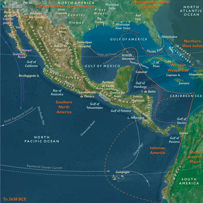
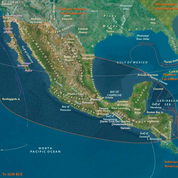
Geographic and Environmental Context
The realm of Middle America joined two distinct but converging landscapes:
the Southern North American isthmus of Mexico and northern Central America, and the Isthmian America belt of Costa Rica, Panama, and the Pacific-Caribbean narrows reaching toward South America.
-
In Southern North America, broad coastal plains flanked the Mexican Plateau and the volcanic highlands of Oaxaca, Chiapas, and the Yucatán. Sea level stood about 100 m lower, exposing vast Gulf and Pacific shelves, wide deltas, and dune-laced lagoons. The interior plateaus were cooler and semi-arid, while pockets of humid gallery forest persisted along the great rivers—the Pánuco, Papaloapan, Grijalva, and Usumacinta.
-
Farther south, Isthmian America narrowed to a rugged volcanic spine split by deep valleys and rain-shadowed coasts. The Darién–Chocó and Nicoya–Azuero zones formed the last humid forest refugia before the Andean world. Off the Pacific, the Galápagos stood as isolated volcanic outposts in a nutrient-rich Humboldt upwelling; to the north, San Andrés and the Caribbean shelves formed the opposite, coral-reef frontier.
Together these subregions already embodied the principle at the heart of The Twelve Worlds: a single “region” composed of two natural worlds—one continental, one inter-oceanic—each more closely tied ecologically to neighbors beyond its borders than to one another.
Climate and Environmental Shifts
Approaching the Last Glacial Maximum, global cooling reshaped Middle America’s climates without erasing their tropical gradients.
-
Cooling and aridity depressed cloud-forest belts and contracted tropical rainforests into riparian refugia.
-
Weakened summer monsoons and stronger winter trades brought long dry seasons to the Mexican Plateau and Pacific slope, while the Caribbean lowlands and Darién retained humid pockets.
-
Upwelling along the Pacific intensified under stronger winds, enriching near-shore fisheries and kelp forests.
-
Sea-level fall widened continental shelves on both coasts, joining islands to mainlands and revealing broad estuarine flats that would later drown beneath Holocene seas.
The result was a continent-spanning ecological mosaic—dry uplands, moist valleys, mangrove estuaries, and kelp-fringed shores—linked by seasonally reliable water corridors.
Lifeways and Early Presence
Direct evidence for people earlier than 30 ka BP remains debated, yet environmental reconstructions show multiple habitable refugia where early foragers could have persisted or passed through:
-
On the Mexican Plateau and Balsas grasslands, hunters followed herds of camelids, horses, bison, and deer across open steppe; small camps clustered near springs and extinct lake margins.
-
Along the Gulf and Caribbean coasts, broad mangrove estuaries offered shellfish, fish, and waterfowl. Cenote chains in the Yucatán provided reliable freshwater in an otherwise dry landscape.
-
The Pacific slope of Chiapas, Oaxaca, and Costa Rica, cooler and drier than today, supported thorn scrub interlaced with riparian woodland—a corridor of perennial rivers and volcanic caves.
-
Within Isthmian America, the Azuero–Nicoya capes and Darién forest refugia combined small-game hunting with reef and mangrove collecting; offshore islands such as San Andrés may have seen brief, resource-tracking visits.
Wherever present, human groups would have lived light on the land, following fresh water and seasonally abundant game, tethered to springs, cenotes, and coasts.
Technology and Material Culture
Toolkits likely mirrored other late Pleistocene foragers of the Americas and adjacent Asia:
-
Flake- and blade-based lithics from local chert, basalt, and obsidian; expedient scrapers and points rather than heavy bifaces.
-
Organic technologies—digging sticks, nets, baskets, and cordage—are inferred from regional parallels.
-
Pigments and ornaments—ochre nodules, shell or tooth beads—suggest symbolic behaviors aligned with global Upper Paleolithic norms.
-
Watercraft were probably dugouts or lashed-bamboo rafts, sufficient for short estuarine crossings along the Gulf or Pacific shelves.
Movement and Interaction Corridors
Middle America’s geography made it both a barrier and a bridge.
-
The Pacific “kelp-edge” highway ran continuously from California through Tehuantepec to Azuero, offering near-shore resources for any south-moving explorers.
-
Inland, the Balsas–Grijalva–Usumacinta–San Juan network formed a continental trunkline between plateau and coast.
-
The Tehuantepec and Nicoya gaps provided the easiest overland passages between oceans.
-
Eastward, the Caribbean strandlines and Yucatán shelves connected into the Antillean realm that would later become the Western West Indies.
These corridors pre-figured the trade, migration, and cultural flows that would dominate the Holocene.
Cultural and Symbolic Expressions
Symbolic evidence, if any, would have been subtle: ochre-stained hearths, bead caches, repeated camp refurbishing—the first marks of territorial familiarity. The interplay of mountain passes, coastal routes, and springs forged a cognitive map of place memory long before agriculture or architecture.
Environmental Adaptation and Resilience
Across both subregions, survival hinged on mobility anchored to water:
-
Refugial tethering—to cenotes, lagoons, and springlines—ensured security during dry phases.
-
Dual coast–interior scheduling diversified diets: marine protein in the dry season, inland plant and game resources when rains returned.
-
Flexibility across ecozones—plateau grasslands, mangrove flats, reef slopes—provided redundancy against climatic oscillation.
In ecological terms, the subregions were already complementary: the continental North offered broad grazing and inland rivers, the Isthmian South condensed resources into humid belts and fertile upwellings.
Transition Toward the Holocene
By 28,578 BCE, the two worlds of Middle America stood poised for transformation:
-
Deglaciation would flood their continental shelves, converting exposed plains into lagoons and archipelagos.
-
Monsoonal recovery would re-link the rainforests of Chiapas, Darién, and the Chocó into one continuous green bridge.
-
Coastal fisheries and freshwater wetlands would become long-term settlement magnets.
When people fully occupied these corridors millennia later, they inherited landscapes already structured by the interlocking logic of refuge and passage—a geography that made Middle America not one land but a hinge between the continents, two natural worlds joined by water and time.
Groups
Commodoties
Subjects
Regions
Subregions
Related Events
Showing 10 events out of 69706 total
Years: 49293BCE - 28578BCE
Groups
Commodoties
Subjects
Regions
Subregions