Southern Macaronesia (7,821 – 6,094 BCE) …
Years: 7821BCE - 6094BCE
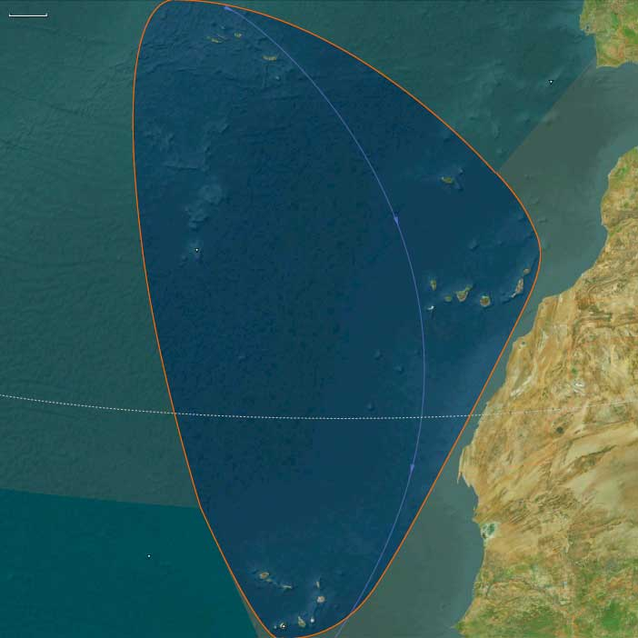
Southern Macaronesia (7,821 – 6,094 BCE) Early Holocene — Cloud-Forest Peaks, Arid Shields, and Seabird Nutrient Pumps (No Humans)
Geographic and Environmental Context
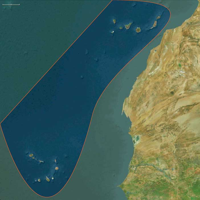
Southern Macaronesia includes:
-
The Canary Islands (Gran Canaria, Tenerife, Fuerteventura, Lanzarote, La Palma, La Gomera, El Hierro).
-
The Cape Verde archipelago (Sotavento and Barlavento groups).
Anchors: Tenerife (Teide massif), Gran Canaria (Caldera de Tejeda), La Palma (Caldera de Taburiente), La Gomera(garajonay–laurisilva), El Hierro (El Golfo fault scarp), Fuerteventura–Lanzarote (low, arid shield islands and malpaísfields), Cape Verde (Fogo stratovolcano, Santo Antão and Santiago highlands, Sal–Boa Vista arid flats).
-
Tenerife/La Palma/Gran Canaria developed robust altitudinal belts (laurel–pine–broom); La Gomera/El Hierro maintained extensive laurisilva; Fuerteventura–Lanzarote remained low, arid, wind-swept.
-
Cape Verde: orographic rainfall on high islands (Fogo, Santo Antão, Santiago), leeward aridity on Sal–Boa Vista–Maio.
Climate & Environmental Shifts
-
Warm, humid Holocene optimum; persistent trades; seasonal rainfall gradient—windward wet, leeward dry.
Subsistence & Settlement
-
None; seabird guano enhanced coastal–islet soils; endemic flora/fauna diversified.
Technology & Material Culture
-
N/A.
Movement & Interaction Corridors
-
Wind/Current systems (Canary Current) and migratory birds; no routine human navigation yet.
Cultural & Symbolic Expressions
-
None.
Environmental Adaptation & Resilience
-
Vertical ecological zonation and fog interception created self-buffering island hydrology.
Transition
By 6,094 BCE, the archipelagos remained pristine, with marked wet–dry island contrasts.
Topics
Subjects
Regions
Subregions
Related Events
Filter results
Showing 10 events out of 69350 total
The period of human history that begins not long after 8000 BCE, which we are about halfway through, is one characterized by the increasing global integration of the various populations of Homo sapiens sapiens.
Human agency also brings about the global integration of various plant and animals, heretofore combined to the continents on which they originally developed.
Another hypothesis suggests the southwestern corner of the Arabian peninsula, in modern-day Yemen, where three now-dry riverbeds indicate good natural pastures existed long ago, perhaps as far back as the Ice Age.
This hypothesis will gaine renewed attention following a 2010 discovery of artifacts dated between 6590 and 7250 BCE in Al-Magar, in southwestern Saudi Arabia, that appear to portray horses.
Regional Variability in the Emergence of the Neolithic
The Neolithic period was marked by the transition from hunter-gatherer societies to farming and permanent settlements, but these developments did not occur simultaneously or in the same order across different regions. Instead, the characteristic elements of the Neolithic—agriculture, animal domestication, pottery, and permanent settlements—emerged at different times and in different sequences around the world.
Divergent Paths to Agriculture and Settlement
- In the Near East, where some of the earliest farming societies developed, pottery was not initially used. Early Neolithic communities practiced cultivation and animal domestication while continuing to rely on stone tools and basketry for food storage.
- In Britain, the extent to which plant domestication played a role in the earliest Neolithic remains uncertain. It is also unclear whether permanently settled communities had fully developed in the initial stages or whether mobility remained a key aspect of life.
Independent Neolithic Developments Beyond Europe and Southwest Asia
While the Near East and Europe were among the first regions to develop agriculture-based societies, other parts of the world experienced independent Neolithic transitions, each following distinct cultural and technological trajectories:
- In Africa, early agricultural systems arose in multiple regions, including the Sahel, the Nile Valley, and Ethiopia, where sorghum and millet were cultivated.
- In South Asia, the Mehrgarh culture (c. 7000 BCE) in present-day Pakistan is one of the earliest known farming communities, practicing wheat and barley cultivation and early forms of cattle domestication.
- In Southeast Asia, rice cultivation developed independently, leading to the formation of distinct Neolithic cultures that spread across the region.
Early Pottery Without Agriculture: The Case of Japan
A striking example of cultural variation in Neolithic development is found in Japan, where early societies produced pottery before adopting agriculture. The Jōmon culture (c. 14,000–300 BCE) crafted some of the earliest known ceramics, used primarily for cooking and storage, long before transitioning to farming practices.
Conclusion: A Complex and Varied Neolithic Transition
The Neolithic transition was not a single, uniform process but rather a series of regionally distinct developments. Some societies adopted agriculture before pottery, while others developed ceramic traditions long before farming. Understanding these regional variations provides deeper insight into the diverse pathways that led to the rise of complex societies across the world.
The Boreal Period: A Transitional Phase in Holocene Climate (c. 9500–7000 BCE)
The Boreal Period (c. 9500–7000 BCE) represents a key transitional phase in the Holocene paleoclimate, situated between the Younger Dryas—the last cold snap of the Pleistocene—and the Atlantic Period, which ushered in warmer and moister conditions than those of the present day.
Although the Boreal climate varied over time, it generally resembled modern conditions, with fluctuating temperatures and precipitation patterns. However, ice core data suggests that around 7911 BCE, a series of seven massive volcanic eruptions—from unknown locations—triggered a prolonged cooling event, which lasted for several centuries and ended around 7090 BCE.
The Transition to the Holocene Climatic Optimum
As the Boreal Period faded, it gave way to:
- The Neolithic Subpluvial (also known as the Holocene Climatic Optimum or Holocene Wet Phase)—a prolonged wet and rainy period that dramatically affected northern Africa, transforming what is now the Sahara Desert into a lush, habitable environment.
- The Atlantic Period, the warmest phase of the Holocene, coinciding with the Neolithic Subpluvial and further shaping the rise of early human civilizations through agriculture and permanent settlement expansion.
Glacial Retreat and Rising Sea Levels in the Holocene
The Holocene Epoch is characterized by the gradual retreat of glacial ice, which reshaped landscapes worldwide. However, between 12,000 and 5000 BCE, massive inland flooding occurred in various regions, leading to abrupt sea level rises.
These rising waters significantly altered coastal landscapes, forcing human populations to migrate inland and adapt to changing environmental conditions. Such rapid shifts may have contributed to oral traditions and flood mythsfound in various ancient cultures, reflecting the profound impact of these climatic events on early human societies.
The Boreal Period thus stands as a pivotal era, bridging the Ice Age and the Holocene's stable climate, setting the stage for human expansion, agriculture, and the development of early civilizations.
A sudden decrease in global temperatures occurred approximately eight thousand two hundred years before the present, or around 6200 BCE, and lasted for the next two to four centuries, an event that climatologists have named he 8.2-kiloyear event.
Swiss botanist Heinrich Zoller first identified a rapid cooling event in 8200 BP in 1960; he named the it the Misox oscillation (for the Val Mesolcina); it is also known in Norway as the Finse event.
Bond, et al., argued that the origin of the 8.2 kiloyear event is linked to a fifteen hundred-year climate cycle; it correlates with Bond event 5.
Milder than the Younger Dryas cold spell that preceded it, but more severe than the Little Ice Age that will follow, the 8.2 kiloyear cooling is a significant exception to general trends of the Holocene climatic optimum.
The strongest evidence for the event comes from the North Atlantic region; the disruption in climate shows clearly in Greenland ice cores and in sedimentary and other records of the temporal and tropical North Atlantic.
It is less evident in ice cores from Antarctica and in South American indices.
The effects of the cold snap are global, however, most notably in changes in sea level during the relevant era.
The initial meltwater pulse may have raised sea levels by as much as 1.2 meters (four feet), but the cooling that followed allows a glacial advance and consequent marine regression.
After two centuries, or by eight thousand years before the present (6000 BCE), global sea level had dropped by fourteen meters (forty-six feet).
After this point, however, milder climate conditions reasserted themselves; by seven thousand eight hundred years before the present (5800 BCE), the global climate returned to pre-event levels.
Temperatures rise, probably to levels similar to those today, and forests expand further, with the ending of the most recent ice age around ten thousand years ago and the beginning of the Holocene era.
The rising sea levels caused by the melting glaciers cut Britain off from Ireland by nine thousand five hundred years ago, and by around 6500 to 6000 BCE, continental Europe is cut off for the last time.
The warmer climate changes the Arctic environment to one of pine, birch, and alder forest; this less open landscape is less conducive to the large herds of reindeer and wild horse that had previously sustained humans.
Those animals are replaced in people's diets by pig and less social animals such as elk, red deer, roe deer, wild boar and aurochs (wild cattle) which would have required different hunting techniques.
Tools change to incorporate barbs that can snag the flesh of an animal, making it harder for it to escape alive.
Tiny microliths are developed for hafting onto harpoons and spears.
Woodworking tools such as adzes appear in the archaeological record, although some flint blade types remain similar to their Paleolithic predecessors.
The dog is domesticated because of its benefits during hunting and the wetland environments created by the warmer weather would have been a rich source of fish and game.
It is likely that these environmental changes are accompanied by social changes.
Humans spread and reach the far north of Scotland during this period.
Northeastern Eurasia (7,821 – 6,094 BCE): Early Holocene — Salmon Rivers, Pottery Frontiers, and Forest–Sea Corridors
Geographic & Environmental Context
From the Upper Volga–Oka and Dnieper–Pripet belts across the Ob–Irtysh–Yenisei to the Amur–Ussuri and the Okhotsk–Bering rim (Sakhalin, Kurils, Kamchatka, Chukchi, northern Hokkaidō), Northeastern Eurasia formed a continuous world of taiga, big rivers, and drowned estuaries. Sea level rise reshaped river mouths into productive bays and tidal flats; inland, lake chains and marshlands multiplied along stabilized watersheds.
Climate & Environmental Shifts
The Holocene thermal optimum brought warmer, wetter, and more even seasonality.
-
Taiga expansion (birch–pine–spruce) advanced north; mixed forests with hazel spread south.
-
Rivers (Volga, Dnieper, Ob, Yenisei, Amur) ran full but steady; estuaries and kelp-lined nearshore waters boomed.
-
Rising seas drowned river mouths, creating ideal passages for anadromous salmon and shellfish-rich flats.
These conditions favored semi-sedentary clustering at confluences, terraces, and tidal margins.
Subsistence & Settlement
A pan-regional broad-spectrum, storage-oriented foraging system matured:
-
East Europe (Upper Volga–Oka, Dnieper, Upper Dvina, Pripet): semi-sedentary river villages with pit-houses focused on sturgeon/pike, elk/boar, hazelnuts, and berries; net-weirs and fish fences anchored seasonal peaks.
-
Northwest Asia (Ob–Irtysh–Yenisei, Altai–Minusinsk): riverine hamlets hunted elk, reindeer, boar; salmon and sturgeon fisheries underwrote wintering; hearth clusters and storage pits marked long occupation.
-
Northeast Asia (Lower/Middle Amur–Ussuri, Okhotsk littoral, Sakhalin–Kurils–Hokkaidō, Kamchatka, Chukchi): salmon-focused semi-sedentism at confluences and tidal flats; smoke-drying and oil rendering produced high-calorie stores; broad-spectrum rounds added elk/reindeer, waterfowl, intertidal shellfish, and seasonal pinnipeds.
Across the span, households returned to the same terraces, bars, and headlands, building place-memory landscapes suited to storage and exchange.
Technology & Material Culture
This was the first great pottery horizon of the north, paired with refined fishing and woodcraft:
-
Early ceramics (7th millennium BCE onward): fiber-/plant- or grit-tempered jars spread in the Upper Volga–Oka, Ob–Yenisei, and Lower Amur, used for boiling fish/meat, fat rendering, and storage; soot-blackened cookpots are typical in the Amur basin.
-
Ground-stone adzes/axes drove canoe- and house-carpentry; composite harpoons, barbed bone hooks, gorges, net sinkers/floats, and stake-weirs scaled mass capture.
-
Personal ornaments of shell, amber, antler, and drilled teeth traveled widely; ochre accompanied burials.
Movement & Interaction Corridors
Waterways made a braided superhighway:
-
Volga–Oka–Dnieper–Dvina canoe circuits linked taiga, marsh, and lake belts; portages stitched watersheds and spread pottery styles.
-
Ob–Irtysh–Yenisei integrated western and central Siberia; the Ural corridor connected taiga foragers with the forest-steppe of Europe.
-
Amur–Sungari tied interior to coast; short-hop voyaging along Sakhalin–Kurils–Hokkaidō moved shell, stone, and ideas; over-ice travel on inner bays persisted in winter.
These lanes provided redundancy—if a salmon run failed locally, neighboring reaches or coastal banks supplied substitutes.
Cultural & Symbolic Expressions
A river-and-animal cosmology left vivid traces:
-
Rock art fields (Minusinsk, Tomsk, Karelia–Alta–Finland) depict elk, fish, boats, hunters, and ritual poses.
-
First-salmon rites are inferred in patterned discard and special hearths; bear and sea-mammal treatments suggest respect for “animal masters.”
-
Cemeteries with ochre, antler and stone grave goods, and—in the northeast—pots in burials formalized ancestry tied to landing places and weirs.
Waterfront mounds and shell/bone-rich zones functioned as ancestral monuments.
Environmental Adaptation & Resilience
Resilience rested on storage + mobility + multi-habitat rounds:
-
Smoke-dried fish, rendered oils, roasted nuts/berries, and cached meats carried camps through winter.
-
River–coast–upland scheduling diversified risk across salmon runs, waterfowl peaks, reindeer/elk migrations, and shellfish seasons.
-
Weir and landing-place tenure, reinforced by ritual, regulated pressure on key stocks and limited conflict.
Long-Term Significance
By 6,094 BCE, Northeastern Eurasia had consolidated into a storage-rich taiga and salmon civilization without agriculture—large, long-lived villages on river terraces and tidal flats; early pottery embedded in daily subsistence; and canoe/ice corridors knitting thousands of kilometers.
These habits—fat economies, ceramic storage, engineered fisheries, and shrine-marked tenure—prepared the ground for larger pit-house villages, denser coastal networks, and, later, steppe–taiga exchanges that would link this northern world to Eurasia at large.
Northeast Asia (7,821 – 6,094 BCE): Early Holocene — Salmon Villages, First Pottery Expansion, and Forest Mosaics
Geographic and Environmental Context
Northeast Asia includes eastern Siberia east of the Lena River to the Pacific, the Russian Far East (excluding the southern Primorsky/Vladivostok corner), northern Hokkaidō (above its southwestern peninsula), and extreme northeastern Heilongjiang.
-
Anchors: the Lower/Middle Amur and Ussuri basins, the Sea of Okhotsk littoral (Sakhalin, Kurils), Kamchatka, the Chukchi Peninsula (with Wrangel Island offshore), northern Hokkaidō, and seasonally emergent shelves along the Bering Sea and northwest Pacific.
Formation of Ancient Paleosiberians and Proto-Amerindian Isolation
By the early Holocene, the Ancient Paleosiberians (AP) had become a distinct population across parts of northeastern Siberia. A key representative comes from a ~9,800 BCE individual from the Kolyma River, whose genome reveals close affinity to the ancestors of Native Americans.
At this stage, the populations ancestral to Native Americans and those remaining in Northeast Asia were still closely related, sharing a mixed ancestry composed of:
-
Ancient North Eurasian (ANE) components of largely West Eurasian origin
-
A deeply diverged East Eurasian lineage, related to but separate from modern East Asians, which had split from their ancestors around 25,000 years ago
This period marks the height of genetic continuity between Siberian and proto-American populations, just before their historical trajectories diverged.
Climate & Environmental Shifts
-
Early Holocene stability: fuller taiga expansion, high river discharges, productive estuaries and nearshore kelp forests.
-
Sea level rising toward modern shorelines created drowned river-mouths ideal for salmon runs.
Subsistence & Settlement
-
Salmon-focused semi-sedentism: repeated aggregation at confluences and tidal flats; smoke-drying and oil rendering supported storage.
-
Broad-spectrum foraging: elk/reindeer, waterfowl, nuts/berries, intertidal shellfish; pinnipeds seasonally.
Technology & Material Culture
-
Early pottery (fiber- and plant-tempered) spread throughout the Lower Amur and coastal basins; soot-blackened cooking jars for fish broths.
-
Ground-stone adzes for woodworking and hollowing logs; composite harpoons; barbed bone fishhooks; net sinkers and floats.
-
Personal ornaments in shell/antler; ochre-rubbed burials.
Movement & Interaction Corridors
-
Amur–Sungari waterway linked interior and coast; short-hop voyaging along Sakhalin–Kurils–Hokkaidō.
-
Seasonal over-ice travel persisted on inner bays; summer canoe movement expanded.
Cultural & Symbolic Expressions
-
First-salmon rites inferred from patterned discard; bear and sea-mammal treatment suggests ritual respect for “animal masters.”
Environmental Adaptation & Resilience
-
Storage + mobility strategy buffered lean runs; multi-habitat rounds (river–coast–upland) diversified risk.
Transition
Toward 6,094 BCE, stable salmon ecologies and expanding early pottery paved the way for larger pit-house villages and richer coastal networks.
Northern North America (7,821 – 6,094 BCE): Early Holocene — Rivers to Seas, Storage Societies, and Canoe Corridors
Geographic & Environmental Context
Northern North America formed a continuous, water-bound world from the Gulf of Alaska and Inside Passage across the Fraser–Columbia–Puget networks and continental interiors to the Great Lakes–St. Lawrence–Gulf of Maine, and south–westward along the Lower Mississippi–Gulf estuaries, California’s delta–coast systems, the Great Basin playas, and the Colorado Plateau canyons.
Postglacial sea rise stabilized rias, drowned river-mouths, and tidal flats on both coasts; inland, high-stand lakes, levee oxbows, and wetlands multiplied, turning the continent into a lattice of salmon rivers, shell bays, and seedlands.
Climate & Environmental Shifts
The Holocene Thermal Maximum brought warmer, wetter, and seasonally reliable conditions.
Conifer forests expanded along the North Pacific; estuaries and kelp forests flourished; the Great Lakes and many interior basins held high stands; Gulf and Atlantic estuaries matured into marsh-rich nurseries. This hydroclimatic equilibrium favored semi-sedentary anchoring at confluences, levees, lagoons, and spring nodes.
Subsistence & Settlement
A continent-spanning broad-spectrum, storage-oriented foraging economy matured:
-
Northwest Pacific & interior plateaus: semi-sedentary salmon villages rose at confluences and tidal flats from Cook Inlet–Prince William Sound to Haida Gwaii–Inside Passage and the Fraser–Columbia. Diets blended salmon, shellfish, marine mammals, deer/elk, waterfowl, berries, camas, acorn/hazelnut. Smokehouses and drying racks proliferated; early shell middens ringed protected bays.
-
Northeast & Great Lakes–St. Lawrence: river–bay hamlets dotted the Chesapeake–Narragansett–Gulf of Maine arc and Great Lakes/Ontario rim. Broad-spectrum economies targeted anadromous runs, waterfowl, deer/boar, nuts and berries; semi-sedentary villages clustered on river benches and levees, accumulating shell/feast deposits.
-
Gulf & Western North America:
Lower Mississippi levee–oxbow hamlets exploited fish, turtles, deer; Gulf estuaries (Mobile–Pensacola–Calusa) sustained rich fisheries. In California, shell-heap villages and inland acorn/oak–pine nut circuits stabilized diets; the Sacramento–San Joaquin delta linked valleys to the coast. Southwest/Great Basinlifeways pivoted on canyon springs, agave/yucca roasts, seed-processing, and fish/waterfowl at shrinking lakes, with camps rotating among micro-patches.
Across regions, households returned to the same dune bars, levees, rock shelters, and spring mounds, building place-memory landscapes while maintaining seasonal breadth.
Technology & Material Culture
A shared water-first toolkit underwrote surplus:
weirs, basket traps, net floats/weights; barbed fishhooks and composite harpoons; ground-stone adzes for hollowing dugouts and heavy carpentry; grinding slabs and mills for seeds and nuts. Dugout canoes ran estuaries, fjords, and deltas; dogs aided hauling and hunts. Ornaments in shell, bone, stone, jet/amber and ochre accompanied feasts and burials. (Earliest pottery remained marginal or absent in these belts; storage was chiefly smoking/drying, fat rendering, and pit caches.)
Movement & Interaction Corridors
Waterways made a braided continental highway:
-
Inside Passage trunklines linked island archipelagos; low-divide portages tied interior lakes to the coast.
-
Great Lakes–St. Lawrence–New England routes integrated bays and inland fisheries; estuary–river–portage chains extended exchange deep into watersheds.
-
Lower Mississippi spine, Gulf inlets, and California delta–Channel Islands circuits moved shellfish, cured fish, nuts, pigments, and fine lithics; Colorado and Rio Grande–Gila–Salt corridors stitched canyons to plains.
These redundancies buffered local failures: if a salmon run dipped or a shell bank waned, another reach or habitat supplied calories and salt.
Cultural & Symbolic Expressions
Ritual mapped onto water and season:
first-salmon observances (curated heads/bones, patterned discard), ancestor cemeteries near shell mounds and river benches, feast middens tied to runs and rookery peaks. Mortuary practices with ochre and bead ornamentsformalized tenure over landings, weirs, and groves. Early rock art and curated hearths marked sacred nodes in canyons and coves.
Environmental Adaptation & Resilience
Security rested on storage + territorial rotation + multi-ecotone scheduling:
smoked/dried fish and meats, rendered oils, roasted seeds/nuts, and camas stores bridged lean months; territorial rotation across river reaches spread harvest pressure; coast/river/upland rounds diversified risk. Tenure customs and alliance feasts regulated access and minimized conflict at key fisheries and groves.
Long-Term Significance
By 6,094 BCE, Northern North America had become a storage-rich, semi-sedentary forager realm: salmon villages and river–bay networks in the Northwest, estuary communities along the Northeast and Great Lakes, and resilient Gulf–West shore and canyon economies. The operating code—canoe logistics, engineered fisheries, surplus management, and shrine-marked tenure—set deep foundations for later ranked coastal households, shell-ring traditions, and copper and canoe exchange spheres of the Middle Holocene.
Years: 7821BCE - 6094BCE
Topics
Subjects
Regions
Subregions