Petrus Plancius, born as Pieter Platevoet in …
Years: 1595 - 1595
Petrus Plancius, born as Pieter Platevoet in Dranouter, now in Heuvelland, West Flanders, had studied theology in Germany and England and at the age of tgwenty-four had become a minister in the Dutch Reformed Church.
Fearing religious prosecution by the Inquisition, he had fled from Brussels to Amsterdam after the city fell to Spanish hands in 1585.
Here he has become interested in navigation and cartography and, being fortunate enough to have access to nautical charts recently brought from Portugal, he had soon been recognized as an expert on the shipping routes to India.
He had collaborated in 1589 with the Amsterdam cartographer Jacob Floris van Langren on a 32.5-centimeter celestial globe, which, using the sparse information available about southern celestial features, for the first time depicts: Crux, the southern cross; Triangulum Australe, the southern triangle; and the Magellanic Clouds, Nubecula Major and Minor.
He had in 1592 published his best known world map titled Nova et exacta Terrarum Tabula geographica et hydrographica.
Apart from maps, he publishes journals and navigational guides and is developing a new method for determining longitude.
He has also introduced the Mercator projection for navigational maps.
In 1595, he asks Pieter Dirkszoon Keyser, the chief pilot on the Hollandia, to make observations to fill in the blank area around the south celestial pole on European maps of the southern sky.
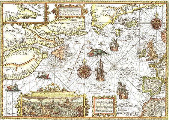
Petrus Plancius: Map of New France (1592-94)
Locations
People
Groups
- Portugal, Habsburg (Philippine) Kingdom of
- Netherlands, United Provinces of the (Dutch Republic)
- Compagnie van Verre
Topics
Commodoties
Subjects
- Commerce
- Products
- Watercraft
- Labor and Service
- Conflict
- Exploration
- Faith
- Government
- Technology
- Cartography
- Astronomy
Regions
Subregions
Related Events
Showing 10 events out of 34263 total
Years: 1595 - 1595
Petrus Plancius: Map of New France (1592-94)
Locations
People
Groups
- Portugal, Habsburg (Philippine) Kingdom of
- Netherlands, United Provinces of the (Dutch Republic)
- Compagnie van Verre
Topics
Commodoties
Subjects
- Commerce
- Products
- Watercraft
- Labor and Service
- Conflict
- Exploration
- Faith
- Government
- Technology
- Cartography
- Astronomy
Regions
Subregions