Only the tribe of Judah had at …
Years: 921BCE - 910BCE
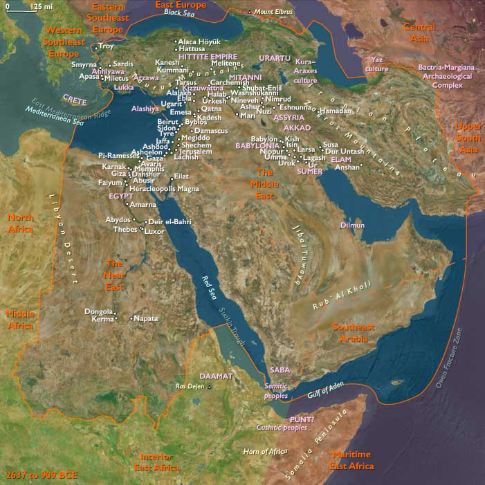
Only the tribe of Judah had at first followed the house of David when the disruption had taken place at Shechem, but the tribe of Benjamin joins the tribe of Judah very soon after, and Jerusalem becomes the capital of the new, poorer, sparsely populated southern kingdom (Joshua 18:28), which is called the kingdom of Judah.
Politically, the state of Israel seems much less politically stable than Judah, maintaining a form of charismatic leadership by merit and competition between ruling families seem to have depended much more on links with outside powers, Tyre, Aram and Assyria, to maintain their authority.
This need to placate powerful neighbors is demonstrated from early in the reign of Jeroboam, when, despite reputedly establishing fortifications at Tirzah, Shechem and Penuel, Israel is invaded by the Biblical Pharaoh Shishak.
Locations
People
Groups
- Assyria, (Middle) Kingdom of
- Tyre, Kingdom of (Phoenicia)
- Aram-Damascus (Syria), Kingdom of
- Egypt (Ancient), Third Intermediate Period of
- Judah, Kingdom of
- Israel (Northern Kingdom of)
Topics
Subjects
Regions
Subregions
Related Events
Filter results
Showing 10 events out of 66855 total
Adad-nirari II, who succeeds his father, Ashur-dan II, in 911, is generally considered to be the first King of Assyria in the Neo-Assyrian period.
Because of the existence of full eponym lists from his reign down to the middle of the reign of Ashurbanipal in the seventh century BCE, year one of his reign in 911 BCE is perhaps the first event in ancient Near Eastern history which can be dated to an exact year, although the Assyrian King List is generally considered to be quite accurate for several centuries before Adad-nirari's reign, and scholars generally agree on a single set of dates back to Ashur-resh-ishi I in the late twelfth century BCE.
Sheshonk takes the Philistine city of Ekron in about 918 BCE in the course of Egypt's conquest of Palestine.
Shoshenq, as Egyptian king, had chosen his eldest son, Osorkon, to succeed him as Osorkon I and consolidated his authority over Egypt through marriage alliances and appointments.
He had designated his second son, Iuput, as the High Priest of Amun at Thebes, Governor of Upper Egypt, and Commander of the Army.
Another son, Nimlot, had been given prominent positions in the military.
Shoshenq is succeeded by his son Osorkon I after a reign of twenty-one years.
While Shoshenq's tomb is currently unknown, the burial of one of his prominent state officials at Thebes, the Third Prophet of Amun Djedptahiufankh, will be discovered intact in Tomb DB320 in the nineteenth Century.
Inscriptions on Djedptahiufankh's mummy bandages show that he died in or after Year Eleven of this king.
His mummy will be discovered to contain various gold bracelets, amulets and precious carnelian objects and give a small hint of the vast treasures that would have adorned Shoshenq I's tomb.
Judah had been humbled by Shoshenq’s invasion, the only recorded intervention of a third party into the affairs of Judah and Israel during Rehoboam's reign, yet hostilities still continue between these two kingdoms.
Rehoboam has fortified the heart of the kingdom, and thus most of the approaches to Jerusalem are flanked by major fortresses.
However, the ascents from the Judean Desert in the east and from the Kingdom of Israel in the north are not covered by the defensive works.
The Judean Desert is a ground to which enemies are to be lured and ambushed, and the Judah-Israel border is not guarded because Rehoboam does not recognize the Kingdom of Israel as an independent state.
Rehoboam's eighteen wives and sixty concubines have borne him eighty-eight children, but he has had the insight to prevent court power struggles by appointing his numerous children to important posts across the country, predominantly away from the capital.
He dies in either 915 (Albright), 914 (Galli), or 913 (Thiele) and is succeeded by his son Abijam ("father of the sea" or "my father is the sea" or "my father is the god Yam").
The Chronicler refers to him as "Abijah ("my father is Yahweh").
Abijam, apparently going to considerable lengths to bring the fledgling Kingdom of Israel back under his control, had waged a major battle against the northern king in the Mountains of Ephraim; the sizes of the two armies are given by II Chronicles as being four hundred thousand and eight hundred thousand respectively.
Abijam had addressed the armies of Israel, telling them to return to his control, but his plea had fallen on deaf ears.
Abijam's elite warriors had fended off a pincer movement to rout Jeroboam, killing over half of his troops.
Thus crippled by this severe defeat at the hands of his southern rival, Jeoboam would not be much of a threat to the Kingdom of Judah for the rest of his reign.
Abijah has had fourteen wives who have borne him thirty-six children; he is succeeded in 913 or 911 by his son Asa.
At around this time people begin to extract iron from the ore in peat bogs.
Evidence of strong Celtic cultural influence dates from this period in Denmark, and in much of northwest Europe, and survives in some of the older place names.
Northeastern Eurasia (909 BCE – 819 CE): Steppe Empires, River Kingdoms, and Forest–Sea Frontiers
Regional Overview
Spanning from the Ural steppes to the Amur River, Northeastern Eurasia was a continental hinge where grasslands, forests, and subarctic coasts met.
It was never a single civilization but an interacting system of three complementary worlds:
-
the Northwest Asian steppes—a domain of horse nomads and shifting empires;
-
the Northeast Asian river–coastal zone—home to Amur polities, sealers, and proto-Ainu cultivators;
-
and the East European forest–steppe—a land of Scythians, Greek ports, and Slavic beginnings.
Across these ecotones, mobility, exchange, and adaptation to cold defined life and linked peoples from the Black Sea to the Pacific.
Geography and Environment
The region’s immensity embraced the Ural Mountains, Ob–Yenisei–Lena river systems, Altai–Sayan uplands, and the Amur–Okhotsk basin.
-
In the steppe belt (Northwest Asia and East Europe), open grasslands favored pastoral nomadism and mounted warfare.
-
In the taiga and tundra, dense forests and rivers sustained hunters and trappers.
-
Along the Amur and Okhotsk coasts, salmon rivers and seal rookeries supported maritime specialists.
Cold winters, brief summers, and erratic rainfall required mobility: herding on the plains, riverine storage, and seaborne subsistence at the coasts.
Climatic fluctuations shifted pastures and forest margins, driving the migrations that repeatedly reshaped this vast northern world.
Societies and Political Developments
The Northwest Steppes: Riders and Confederacies
Early Saka–Scythian cultures (1st millennium BCE) pioneered mounted archery, burial mounds, and trade routes linking the Altai to the Black Sea.
Their successors—the Xiongnu, Huns, and Türkic Khaganates—forged nomadic empires between the 3rd century BCE and the 8th century CE, commanding the Eurasian steppe road.
Pastoral clans of Sarmatians, Saka, and later Turks traded horses, felt, and slaves for silk, metalwork, and glass, while Ket, Samoyedic, and Evenki forest peoples maintained autonomy through trapping and fishing.
The East European Forest–Steppe: Traders, Farmers, and Frontiers
Between the Dniester and the Volga, Scythian and later Sarmatian riders ruled the Pontic plains; Greek colonies such as Olbia, Chersonesus, and Bosporus exported grain and slaves to the Mediterranean.
In the forest–steppe, Balts, Finno-Ugrians, and Slavic ancestors lived in mixed economies of farming, beekeeping, and fur trade.
By the early centuries CE, the Chernyakhiv culture bridged steppe and forest zones; later, Goths, Huns, and Avars swept westward, followed by the Khazars, who by the 7th century commanded the lower Volga.
Early Slavic settlements spread through the Dnieper basin, foreshadowing Kyivan Rus’.
The Amur–Okhotsk Northeast: River Chiefdoms and Sea Hunters
In the far east, Sushen/Mohe polities along the Amur taxed fish, furs, and horses, governing plank-built towns with storage pits and palisades.
Coastal Okhotsk communities specialized in sealing, whaling, and oil rendering, while inland clans hunted elk and reindeer.
On northern Hokkaidō, the Epi-Jōmon culture gave way to early Satsumon societies, incorporating iron tools and small-scale cultivation—precursors to later Ainu identity.
These eastern networks interacted with the Korean and Chinese frontiers, feeding iron, silk, and ceramics into local economies.
Economy and Exchange
Trade and mobility united the region more than empire or language.
Three great corridors structured movement:
-
The Steppe Road, carrying silk, metals, and horses between China, Persia, and the Black Sea.
-
The River Arteries, where the Ob, Yenisei, and Volga funneled furs, wax, and fish to southern markets.
-
The Amur–Okhotsk–Sakhalin Circuit, exchanging seal oil, ivory, and iron among coastal peoples.
Greek ports, Turkic caravan cities, and Amur villages each served as nodes of this transcontinental traffic.
Technology and Material Culture
Iron transformed toolkits across all zones: swords and plowshares in the steppe, adzes and awls in the taiga, harpoons and knives on the coast.
The stirrup and saddle revolutionized steppe warfare; dugout canoes and skin boats extended inland and maritime reach.
Pottery traditions remained diverse—black-burnished wares in the steppe, cord-impressed in the forest, thick-walled cooking jars in the Amur basin.
Animal-style art, petroglyphs, and totemic carvings reveal a shared aesthetic of motion and metamorphosis across peoples separated by thousands of kilometers.
Belief and Symbolism
Religion everywhere mirrored ecology.
-
Steppe nomads worshiped the Sky-God Tengri and honored ancestors through kurgan burials.
-
Forest and river peoples followed shamanic cosmologies tied to animals, trees, and water spirits.
-
Along the Amur and Okhotsk coasts, bear-sending rituals and first-salmon feasts expressed reciprocity with nature.
Greek colonies introduced Mediterranean cults, while Khazar and Bulgar elites later adopted Judaism and Islam—diversity without uniformity.
Adaptation and Resilience
Survival depended on mobility, diversity, and exchange.
Nomads tracked rainfall across steppe belts; hunters stored dried fish and smoked meat; sealers preserved oil in skin bags for the long winter.
The integration of horse, reindeer, and dog traction multiplied travel options; iron tools extended fuel and housing resources.
Polities rose and fell with climate and trade, yet the regional system endured through flexible kin alliances and shared environmental knowledge.
Regional Synthesis and Long-Term Significance
By 819 CE, Northeastern Eurasia was a mature transcontinental world:
-
The Northwest steppes had evolved from Scythian to Türkic empires, perfecting cavalry and steppe diplomacy.
-
The East European forests and rivers nurtured Slavic and Finno-Ugric communities, integrating them into the Khazar and Bulgar trade webs.
-
The Northeast river–coastal arc blended Amur chiefdoms, Okhotsk sealers, and proto-Ainu cultivators, joining the Asian mainland to the North Pacific.
This tri-zonal equilibrium—steppe mobility, forest production, maritime specialization—defined the ecological and cultural balance of northern Eurasia.
Out of it would emerge the medieval Turkic and Mongolic empires, the Rus’ river states, and the Ainu and Japanese North Pacific frontier, each inheriting the mobility, adaptability, and cosmopolitan exchange first forged in this early age.
Northeast Asia (909 BCE – 819 CE): River Kingdoms, Coastal Specialists, and Toward Satsumon and Okhotsk
Northeast Asia includes eastern Siberia east of the Lena River to the Pacific, the Russian Far East (excluding the southern Primorsky/Vladivostok corner), northern Hokkaidō (above its southwestern peninsula), and extreme northeastern Heilongjiang.
-
Anchors: Lower Amur polities (proto-Mohe/Sushen), Ussuri towns, Sakhalin landing nodes, Okhotsk seal/whale stations, northern Hokkaidō (Epi-Jōmon → Satsumon trajectory).
Climate & Environmental Shifts
-
First-millennium variability; ice-edge polynyas reliable; river freeze–thaw structured travel calendars.
Subsistence & Settlement
-
Amur river kingdoms consolidated tribute in fish, furs, and horses; fortified villages with plank halls and big storage.
-
Okhotsk coastal specialists (mid–late 1st millennium CE) mastered sealing/whaling, dog-keeping, and winter oil technologies; shell mounds and bear rites diagnostic.
-
Northern Hokkaidō transitioned from Epi-Jōmon to early Satsumon (late in period), with pottery change, iron use, and limited cultivation at southern margins.
Technology & Material Culture
-
Iron from mainland routes integrated into knives, awls, spearheads; bone harpoons with toggling heads remained indispensable.
-
Pottery diversified (thicker-walled cooking/storage), soapstone lamps, leather/skin parkas; skis and snowshoes inland.
Movement & Interaction Corridors
-
Amur–Sungari–Korean axis funneled iron and horses; Sakhalin–Hokkaidō ferries moved metals and ceramics; Okhotsk coastal runs spread salt and oils.
Cultural & Symbolic Expressions
-
Bear-sending rituals, first-salmon rites, and ancestor memorials knit communities; lineage emblems appeared on grave goods and house posts.
Environmental Adaptation & Resilience
-
Tri-zonal adaptation (riverine storage, coastal sealing, taiga hunting) created redundancy; iron adoption enhanced woodworking/canoe repair and sewing.
Legacy & Transition
By 819 CE, Northeast Asia exhibited the cultural precursors of the medieval Okhotsk sphere and Hokkaidō’s Satsumon communities—maritime specialists and riverine chiefdoms enmeshed in Amur–Japan Sea exchange, setting the stage for later Ainu ethnogenesis and North Pacific interactions.
Northern North America (909 BCE – 819 CE): From Arctic Seas to Riverine Towns — The Deep Foundations of the Continent
Regional Overview
From the drifting pack ice of the Arctic Ocean to the salmon canyons of the Fraser and Columbia, and from the birch forests of the Great Lakes to the mounds of the Mississippi, Northern North America in the first millennium BCE through the early centuries CE formed a continental lattice of waterways, fisheries, and overland trails.
Across this vast region, societies diversified around the rhythm of rivers and the reach of coastlines — Arctic seal hunters, Pacific longhouse chiefs, Woodland farmers, and Plains foragers each adapting to their ecologies while linked through far-flung exchange.
By 819 CE, the northern half of the continent had achieved a remarkable cultural equilibrium: stable regional traditions, robust interzonal trade, and the institutional seeds that would flower into the Thule migrations, Mississippian towns, and Northwest Coast chiefdoms of the coming age.
Geography and Environment
Northern North America embraced the Arctic littoral, the North Pacific coast, the continental interior, and the temperate forests bordering the Atlantic.
-
The Arctic and subarctic stretched from the Yukon to Baffin Bay, its coasts ruled by sea-ice cycles and river estuaries rich in fish and seals.
-
The Northwest Coast offered mild, wet climates and dense conifer forests, sustaining some of the highest population densities north of Mesoamerica.
-
The Interior Plains and Plateaus were threaded by the Mississippi, Missouri, and Columbia systems — arteries of migration and exchange.
-
The Northeastern woodlands combined mixed farming with forest hunting, while the Great Lakes and St. Lawrence corridors linked interior and Atlantic ecologies.
Climatic variability shaped mobility rather than collapse: alternating warm and cool pulses adjusted the balance between farming and foraging, while vast ecological diversity ensured regional resilience.
Societies and Political Developments
Arctic and Subarctic Horizons
In the western Arctic, the Norton tradition (c. 1000 BCE – 800 CE) established semi-subterranean house villages, oil-lamp economies, and net fisheries across Alaska’s bays and rivers.
By the mid-first millennium CE, Birnirk innovations — sea-ice whaling, toggling harpoons, refined bone and ivory craft — emerged on the North Slope, setting the technological stage for the Thule expansion.
Inland, Athabaskan foragers managed caribou and salmon cycles through flexible band networks stretching from the Yukon to the Mackenzie.
The North Pacific Coast
Southward, the ranked longhouse societies of the Haida, Tlingit, Tsimshian, and related peoples achieved a mature social hierarchy centuries before written history: hereditary chiefs, clan crests, and ceremonial redistribution through feast-traditions ancestral to the later potlatch.
Villages of massive cedar plank houses lined Haida Gwaii, the central BC fjords, and the Puget Sound.
Farther inland, Plateau communities along the Fraser and Columbia Rivers built pit-house towns near salmon canyons, tightly integrated with coastal exchange.
The Eastern Woodlands and Arctic Threshold
In the east, Late Woodland cultures consolidated from the Great Lakes to the Appalachians.
Fortified longhouse villages in Ontario and New York foreshadowed Iroquoian confederacies.
Southward along the Mississippi–Ohio system, mound centers continued the Hopewell legacy and anticipated Mississippian complexity.
On the Atlantic, shell-heap villages thrived from Chesapeake to the Gulf of Maine.
Farther north, Dorset Paleo-Inuit traditions persisted across the Eastern Arctic, with the coming Thule and, later, Norse Greenlanders still centuries ahead.
Economy and Trade
Across the region, economic life revolved around seasonal abundance and long-distance circulation.
-
Arctic and Subarctic peoples balanced sea-mammal hunting, fishing, and caribou herding, exchanging furs, ivory, and stone for metal and wood from the south.
-
Coastal chiefdoms specialized in salmon, eulachon oil, cedar timber, and carved prestige goods of copper and shell, exported inland along “grease trails.”
-
Interior and Woodland farmers combined maize, beans, and squash with hunting and fishing; their towns became marketplaces for copper, obsidian, mica, and shell ornaments.
-
River and lake corridors — Yukon, Fraser, Columbia, Mississippi, St. Lawrence — functioned as the highways of pre-Columbian North America, linking ecological zones into continental exchange.
Technology and Material Culture
Technological ingenuity was universal yet regionally distinct.
-
Arctic engineers developed the qayaq and umiak, bone-framed sleds, toggling harpoons, and oil lamps for polar survival.
-
Northwest Coast carpenters perfected adzes, chisels, and caulking for seaworthy canoes and monumental architecture.
-
Woodland artisans produced cord-marked pottery, copper ornaments, and polished stone tools.
-
Irrigation in the desert Southwest (to the south) influenced maize cultivation reaching the Lower Mississippi; meanwhile, storage pits, smoking racks, and plank granaries became standard food-security technologies across the temperate north.
Belief and Symbolism
Religious and ceremonial life bound ecology to ancestry.
-
Along the Pacific Coast, first-salmon rites, crest art, and mortuary feasts articulated kin identity and ecological reciprocity.
-
In the Woodlands, mound burials, clan totems, and cosmologies of the four directions organized both ritual and landscape design.
-
In the Arctic, shamanic traditions mediated between human and animal spirits, honoring the souls of seals, whales, and caribou.
Art, dance, and ritual reaffirmed the moral equilibrium between community and environment, making cosmology a practical guide for survival.
Adaptation and Resilience
Environmental diversity bred redundancy and cooperation.
Food storage, alliance marriages, and ritual feasting functioned as social insurance systems against famine or climatic shock.
Riverine and coastal corridors allowed mobility when drought, ice, or conflict disrupted one zone.
Technological convergence — woodcraft, metallurgy, navigation, and agriculture — produced a continental safety net of knowledge.
Regional Synthesis and Long-Term Significance
By 819 CE, Northern North America had matured into a web of complementary cultural systems:
-
Arctic Norton–Birnirk foragers poised for the Thule transformation;
-
Northwest Coast longhouse chiefdoms achieving classical complexity;
-
Interior and Woodland farmers consolidating the Late Woodland world;
-
Atlantic and Great Lakes peoples connecting interior and ocean through canoe exchange.
This mosaic — continental in scale yet locally precise — provided the infrastructure for the continent’s medieval efflorescence: Thule migrations across the Arctic, the rise of Cahokia and its mound-town network, and the flourishing of Northwest Coast monumental art.
In environmental and cultural resilience, Northern North America was already a mature world — one whose diversity and interconnection would shape the hemispheric story for centuries to come.
From ASTt to Old Bering Sea, Okvik, and Punuk
On the western side of the Arctic, innovation accelerated. By the second century CE, the Old Bering Sea culture flourished along the Alaskan and Chukotkan coasts and on the islands between. Its artisans created engraved ivory harpoon heads and tools, marrying artistry with maritime hunting of seals, walrus, and whales.
By the mid-third century, the Okvik culture emerged on the Punuk Islands, carving bold spirals and faces into ivory and developing a distinctive stylistic identity while continuing marine subsistence.
Finally, by the late seventh century, the Punuk culture spread across the Strait. Their subterranean houses framed with whale jawbones, and their focus on cooperative whale hunts, marked a major shift to larger, more permanent settlements and complex social life.
This west Arctic trajectory culminated in the maturation of the Thule tradition, which would soon expand eastward to reshape all of Arctic North America.
Years: 921BCE - 910BCE
Locations
People
Groups
- Assyria, (Middle) Kingdom of
- Tyre, Kingdom of (Phoenicia)
- Aram-Damascus (Syria), Kingdom of
- Egypt (Ancient), Third Intermediate Period of
- Judah, Kingdom of
- Israel (Northern Kingdom of)
Topics
Subjects
Regions
Subregions