Northern North America (7,821 – 6,094 BCE): …
Years: 7821BCE - 6094BCE
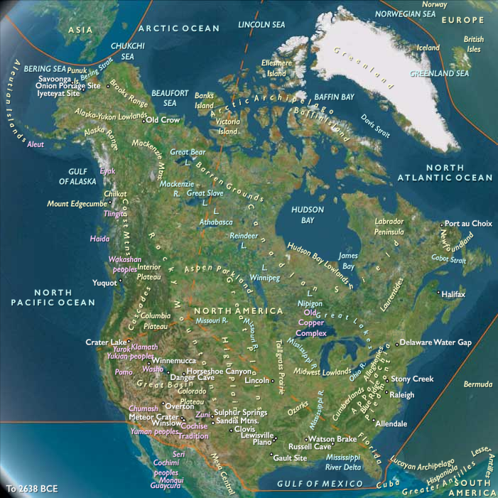
Northern North America (7,821 – 6,094 BCE): Early Holocene — Rivers to Seas, Storage Societies, and Canoe Corridors
Geographic & Environmental Context
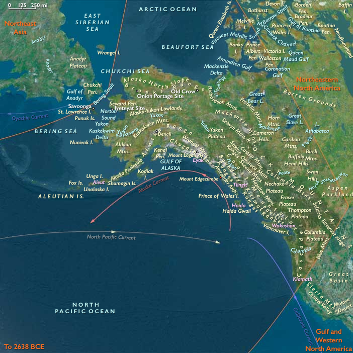
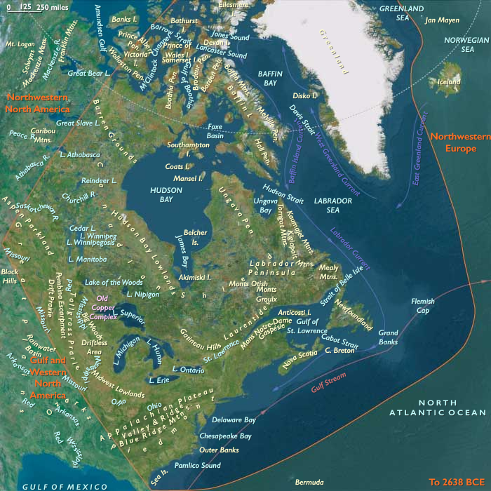
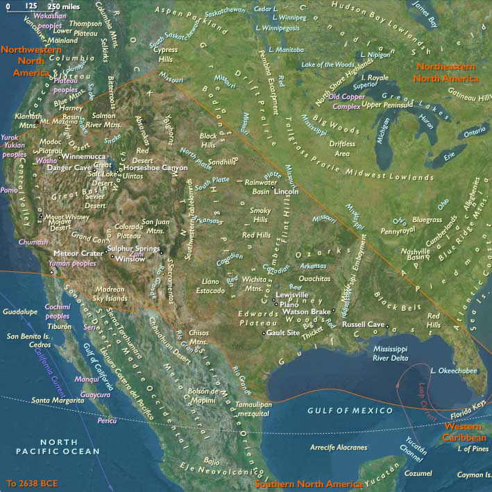
Northern North America formed a continuous, water-bound world from the Gulf of Alaska and Inside Passage across the Fraser–Columbia–Puget networks and continental interiors to the Great Lakes–St. Lawrence–Gulf of Maine, and south–westward along the Lower Mississippi–Gulf estuaries, California’s delta–coast systems, the Great Basin playas, and the Colorado Plateau canyons.
Postglacial sea rise stabilized rias, drowned river-mouths, and tidal flats on both coasts; inland, high-stand lakes, levee oxbows, and wetlands multiplied, turning the continent into a lattice of salmon rivers, shell bays, and seedlands.
Climate & Environmental Shifts
The Holocene Thermal Maximum brought warmer, wetter, and seasonally reliable conditions.
Conifer forests expanded along the North Pacific; estuaries and kelp forests flourished; the Great Lakes and many interior basins held high stands; Gulf and Atlantic estuaries matured into marsh-rich nurseries. This hydroclimatic equilibrium favored semi-sedentary anchoring at confluences, levees, lagoons, and spring nodes.
Subsistence & Settlement
A continent-spanning broad-spectrum, storage-oriented foraging economy matured:
-
Northwest Pacific & interior plateaus: semi-sedentary salmon villages rose at confluences and tidal flats from Cook Inlet–Prince William Sound to Haida Gwaii–Inside Passage and the Fraser–Columbia. Diets blended salmon, shellfish, marine mammals, deer/elk, waterfowl, berries, camas, acorn/hazelnut. Smokehouses and drying racks proliferated; early shell middens ringed protected bays.
-
Northeast & Great Lakes–St. Lawrence: river–bay hamlets dotted the Chesapeake–Narragansett–Gulf of Maine arc and Great Lakes/Ontario rim. Broad-spectrum economies targeted anadromous runs, waterfowl, deer/boar, nuts and berries; semi-sedentary villages clustered on river benches and levees, accumulating shell/feast deposits.
-
Gulf & Western North America:
Lower Mississippi levee–oxbow hamlets exploited fish, turtles, deer; Gulf estuaries (Mobile–Pensacola–Calusa) sustained rich fisheries. In California, shell-heap villages and inland acorn/oak–pine nut circuits stabilized diets; the Sacramento–San Joaquin delta linked valleys to the coast. Southwest/Great Basinlifeways pivoted on canyon springs, agave/yucca roasts, seed-processing, and fish/waterfowl at shrinking lakes, with camps rotating among micro-patches.
Across regions, households returned to the same dune bars, levees, rock shelters, and spring mounds, building place-memory landscapes while maintaining seasonal breadth.
Technology & Material Culture
A shared water-first toolkit underwrote surplus:
weirs, basket traps, net floats/weights; barbed fishhooks and composite harpoons; ground-stone adzes for hollowing dugouts and heavy carpentry; grinding slabs and mills for seeds and nuts. Dugout canoes ran estuaries, fjords, and deltas; dogs aided hauling and hunts. Ornaments in shell, bone, stone, jet/amber and ochre accompanied feasts and burials. (Earliest pottery remained marginal or absent in these belts; storage was chiefly smoking/drying, fat rendering, and pit caches.)
Movement & Interaction Corridors
Waterways made a braided continental highway:
-
Inside Passage trunklines linked island archipelagos; low-divide portages tied interior lakes to the coast.
-
Great Lakes–St. Lawrence–New England routes integrated bays and inland fisheries; estuary–river–portage chains extended exchange deep into watersheds.
-
Lower Mississippi spine, Gulf inlets, and California delta–Channel Islands circuits moved shellfish, cured fish, nuts, pigments, and fine lithics; Colorado and Rio Grande–Gila–Salt corridors stitched canyons to plains.
These redundancies buffered local failures: if a salmon run dipped or a shell bank waned, another reach or habitat supplied calories and salt.
Cultural & Symbolic Expressions
Ritual mapped onto water and season:
first-salmon observances (curated heads/bones, patterned discard), ancestor cemeteries near shell mounds and river benches, feast middens tied to runs and rookery peaks. Mortuary practices with ochre and bead ornamentsformalized tenure over landings, weirs, and groves. Early rock art and curated hearths marked sacred nodes in canyons and coves.
Environmental Adaptation & Resilience
Security rested on storage + territorial rotation + multi-ecotone scheduling:
smoked/dried fish and meats, rendered oils, roasted seeds/nuts, and camas stores bridged lean months; territorial rotation across river reaches spread harvest pressure; coast/river/upland rounds diversified risk. Tenure customs and alliance feasts regulated access and minimized conflict at key fisheries and groves.
Long-Term Significance
By 6,094 BCE, Northern North America had become a storage-rich, semi-sedentary forager realm: salmon villages and river–bay networks in the Northwest, estuary communities along the Northeast and Great Lakes, and resilient Gulf–West shore and canyon economies. The operating code—canoe logistics, engineered fisheries, surplus management, and shrine-marked tenure—set deep foundations for later ranked coastal households, shell-ring traditions, and copper and canoe exchange spheres of the Middle Holocene.
Groups
Topics
- Neolithic Revolution
- Boreal Period
- Archaic Stage (Americas)
- Neolithic Subpluvial, or Holocene climatic optimum, or Holocene Wet Phase
- Atlantic Period during the Neolithic Subpluvial
- 8.2 kiloyear event during the Neolithic Subpluvial
Commodoties
Subjects
Regions
Subregions
Related Events
Showing 10 events out of 28 total
Years: 7821BCE - 6094BCE
Groups
Topics
- Neolithic Revolution
- Boreal Period
- Archaic Stage (Americas)
- Neolithic Subpluvial, or Holocene climatic optimum, or Holocene Wet Phase
- Atlantic Period during the Neolithic Subpluvial
- 8.2 kiloyear event during the Neolithic Subpluvial
Commodoties
Subjects
Regions
Subregions