Northern West Indies (49,293–28,578 BCE) Upper …
Years: 49293BCE - 28578BCE
Northern West Indies (49,293–28,578 BCE) Upper Pleistocene I — Reef Benches, Limestone Lenses, and Seabird Realms (No People)
Geographic and Environmental Context
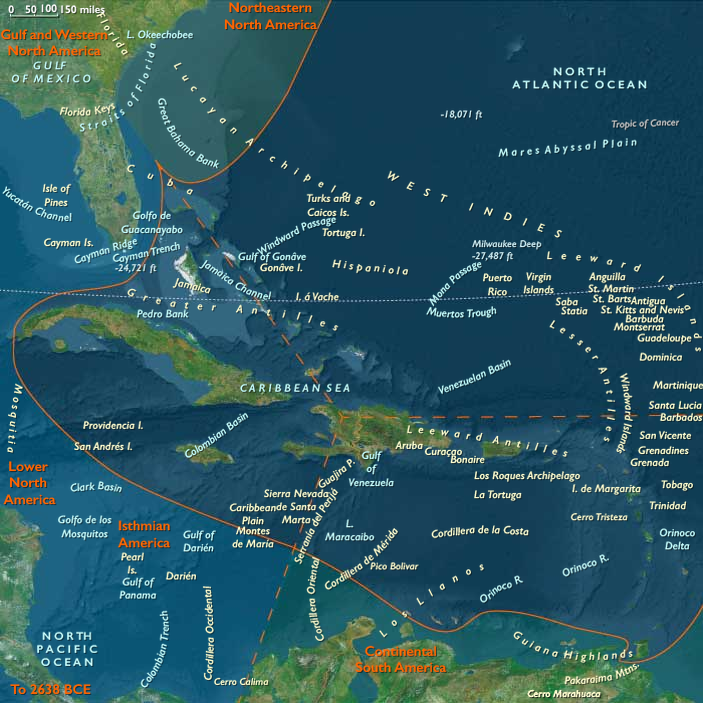
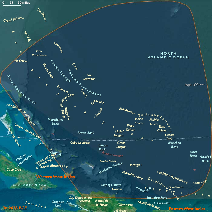
Northern West Indies includes the Outer Bahamas (Lucayan archipelago), the Turks & Caicos Islands, and northern Hispaniola — northern Haiti (Cap-Haïtien, Massif du Nord) and the Cibao/north coast of the Dominican Republic (Santiago de los Caballeros, Puerto Plata).
Anchors: Andros–Abaco–Eleuthera–San Salvador–Exuma banks, Turks & Caicos banks and passes, Cap-Haïtien–Massif du Nord, Cibao–Puerto Plata–Santiago river valleys and coastal shelves.
-
Sea level ~100 m lower exposed broad carbonate benches and dune fields on Bahama and Caicos banks; northern Hispaniola held narrow shelf and uplifted limestone foothills.
Climate & Environmental Shifts
-
LGM cooling strengthened winter trades and lowered SSTs; upwelling pulses still supported reef productivity.
Subsistence & Settlement
-
No human occupation; seabird/turtle rookeries and shallow lagoons formed dense trophic webs.
Technology & Material Culture — N/A.
Movement & Interaction Corridors
-
Ocean currents (Florida Current/North Equatorial) set cross-bank drift patterns; purely ecological connectivity.
Cultural & Symbolic Expressions — N/A.
Environmental Adaptation & Resilience
-
Pristine island biotas matured on freshwater lenses beneath the larger cays.
Transition
By 28,578 BCE, the banks and north Hispaniola coast were high-productivity carbonate landscapes awaiting people.
Topics
Commodoties
Subjects
Regions
Subregions
Related Events
Showing 10 events out of 69706 total
Years: 49293BCE - 28578BCE
Topics
Commodoties
Subjects
Regions
Subregions