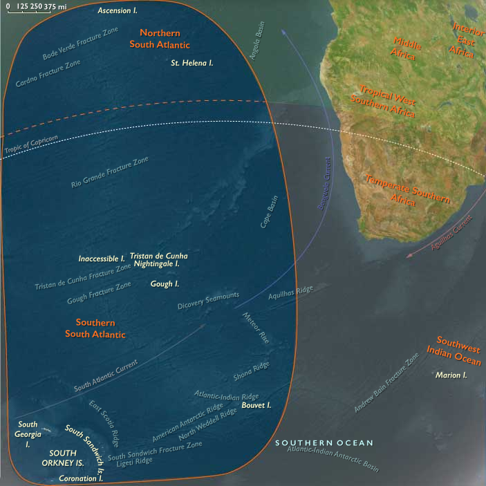
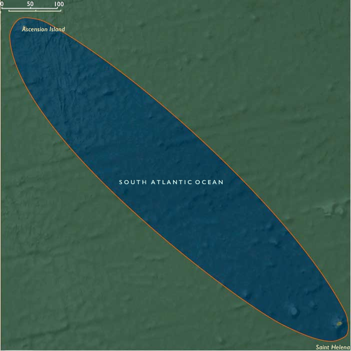
Northern South Atlantic (1540–1683 CE) Watering …
Years: 1540 - 1683
Northern South Atlantic (1540–1683 CE)
Watering Rocks, East–Indies Waystations, and First Forts
Geography & Environmental Context
Northern South Atlantic comprises Saint Helena and Ascension Island—two volcanic outcrops on the Cape Route between Europe and the Indian Ocean. Anchors include Saint Helena’s sheer basalt cliffs, the deep cleft of Jamestown valley, perennial springs and cloud-forest heights, and Ascension’s bare lava cones and turtle beaches. Isolated by thousands of kilometers of ocean, the pair formed a natural victualling chain for fleets rounding the Cape of Good Hope.
Climate & Environmental Shifts
Trade-wind belts delivered cool, misty uplands and drier leeward slopes on Saint Helena, sustaining springs and pockets of montane greenery. Ascension was markedly arid, with scarce freshwater and episodic rains. Within the Little Ice Age, cool spells and irregular precipitation tightened water budgets; ship captains timed calls to reliable springs and turtle seasons. Steep gradients on Saint Helena concentrated rainfall in cloud belts, while exposed coasts faced relentless swell and sudden squalls.
Subsistence & Settlement
-
Pre-colony usage: Through the 1500s–1600s both islands were uninhabited but frequently visited. Portuguese, then VOC and English East India Company (EIC) ships cut wood, filled casks, grazed introduced goats, planted fruit trees, and hunted turtles (Ascension).
-
Saint Helena colony (from 1659): The EIC established a permanent garrison and settlers under a governor, terracing slopes for gardens, orchards, and small livestock. Springs fed kitchen plots; imported grain and salted provisions remained essential.
-
Ascension: No permanent settlement; crews landed for turtles, fish, and the occasional ad-hoc cistern repair.
Technology & Material Culture
Oceanic visitors evolved from Iberian naus and carracks to larger East Indiamen and VOC fluyts. On Saint Helena, the EIC built stone batteries, storehouses, and pathways up the cliffs; cisterns and conduits captured springwater. Ship carpenters felled endemic trees for spars; introduced fruit (citrus, figs) and garden crops improved diet against scurvy. Everyday material life mixed sailor’s kit—barrels, cordage, iron tools—with fledgling colonial masonry and terracing.
Movement & Interaction Corridors
-
Cape Route trunk: The Carreira da Índia, VOC circuits, and EIC fleets stitched the islands to Lisbon, Amsterdam, London, the Cape, and Goa–Batavia.
-
Privateers & wartime detours: Anglo-Dutch rivalry diverted convoys to secure watering points; Saint Helena’s anchorage became a convoy mustering spot.
-
Intra-island rhythms: Saint Helena’s springs dictated anchorage schedules; Ascension’s turtle season shaped provisioning calls.
Cultural & Symbolic Expressions
Mariners’ journals, charts, and shipboard songs cast the islands as providential havens—“the island of good water”and a “turtle bank” in the mid-ocean. Early EIC proclamations invoked royal and corporate authority; Sunday musters, militia drill, and church services in Jamestown valley formalized a miniature maritime society. Wreck tales along Saint Helena’s cliffs and Ascension’s surf entered Atlantic lore.
Environmental Adaptation & Resilience
-
Introductions: Goats, pigs, and fruit trees expanded shipboard diet but began eroding Saint Helena’s native cover.
-
Water discipline: Spring protection, cask rotation, and cistern maintenance underpinned survival; ships staggered arrivals to avoid exhausting flows.
-
Mixed subsistence: Garden terraces, small stock, fishing, and barter with passing vessels balanced irregular supply.
-
Risk buffers: Convoys and duplicate waystations (Ascension as backup to Saint Helena) hedged against drought, foul weather, or hostile cruisers.
Political & Military Shocks
-
Corporate colonization (1659): The EIC fortified Saint Helena, asserting exclusive watering rights on the homeward run from Asia.
-
Anglo-Dutch Wars: Dutch claims and raids (including a brief seizure in 1673) prompted stronger fortifications before the English re-established control.
-
Imperial signaling: Flag-raisings, salutes, and coastal batteries advertised possession to rival fleets in a corridor critical to Asian trade.
Transition
Between 1540 and 1683, the Northern South Atlantic shifted from unpeopled rocks in Iberian sailing directions to a strategic EIC colony (Saint Helena) paired with a provisioning outpost (Ascension). Springs, turtles, and cliff-secured anchorages made the difference between safe passage and disaster on the Cape Route. By the early 1680s, Jamestown’s guns, gardens, and garrison anchored England’s Indian Ocean highway—foreshadowing the islands’ lasting role as mid-Atlantic hinges of empire.
Groups
- Portugal, Avizan (Joannine) Kingdom of
- Portuguese Empire
- Portugal, Habsburg (Philippine) Kingdom of
- East India Company, British (The Company of Merchants of London Trading into the East Indies)
- Dutch East India Company (Vereenigde Oostindische Compagnie or VOC in Dutch, literally "United East Indies Company")
- Dutch East India Company (Vereenigde Oostindische Compagnie or VOC in Dutch, literally "United East Indies Company")
- Portugal, Bragança Kingdom of
Topics
Commodoties
Subjects
Regions
Subregions
Related Events
Filter results
Showing 10 events out of 37475 total
We begin in the easternmost subregions and move westwardly around the globe, crossing the equator as many as six times to explore ever shorter time periods as we continue to circle the planet. The maps of the regions and subregions change to reflect the appropriate time period.
Narrow results by searching for a word or selecting from one or more of a dozen filters.
West Micronesia (1540–1683 CE): Stone Cities, Sea Roads, and the First Shadows of Empire
Geography & Environmental Context
West Micronesia includes the Mariana Islands (Guam, Saipan, Tinian, Rota, and smaller islets), the western Caroline Islands (Palau, Yap), and nearby atolls. Anchors include the limestone plateaus and volcanic ridges of Guam and Saipan, the volcanic and coral mix of Palau, and the high islands and lagoon systems of Yap. These islands lie at the meeting point of Pacific trade winds and equatorial currents, creating a zone where fertile volcanic soils, coral reefs, and extensive lagoons shaped settlement and subsistence.
Climate & Environmental Shifts
The climate was tropical, with warm temperatures year-round, abundant rainfall on volcanic islands, and thinner freshwater resources on limestone islands and atolls. The Little Ice Age brought modest cooling and rainfall variability, with droughts especially affecting limestone islands of the Marianas. Typhoons frequently struck, damaging breadfruit groves, houses, and canoes. Yet the abundance of reef fisheries and resilient arboriculture (coconut, breadfruit, taro) provided buffers against environmental shocks.
Subsistence & Settlement
-
Marianas: Villages clustered along coastal terraces, with houses built on raised latte stone pillars, a hallmark of Chamorro architecture. Farming combined taro, yam, and breadfruit cultivation with fishing, shellfish gathering, and coconut harvesting.
-
Yap: Intensive taro pond-field systems sustained dense populations, supplemented by breadfruit and coconuts. Stone money (rai discs) began circulating in ritual and political contexts.
-
Palau: Fertile volcanic soils supported shifting gardens of taro, yam, and breadfruit, alongside rich lagoon fisheries. Settlements concentrated near waterways and coastal bays.
Technology & Material Culture
Stone adzes, shell tools, and wooden implements shaped daily life. Canoe-building was highly developed, with outrigger canoes and sailing vessels enabling long-distance voyaging across the Caroline chain. In the Marianas, latte stone pillars served both practical and symbolic functions as house foundations and status markers. Rai stones of Yap, quarried in Palau and transported hundreds of kilometers, embodied wealth, prestige, and social authority. Woven mats, ornaments of shell and bone, and ceremonial dress reflected artistry and status. In Palau, stone terraces, causeways, and earthworks reflected both engineering skill and organized labor.
Movement & Interaction Corridors
West Micronesia was a hub of exchange and mobility:
-
Caroline seafarers connected Yap and Palau with outer atolls, exchanging taro, breadfruit, fish, and prestige goods.
-
Rai stone money circulated between Yap and Palau, anchoring a long-distance system of wealth and alliance.
-
Chamorro voyagers linked the Mariana Islands, sustaining kinship ties and ritual networks across the chain.
-
By the mid-16th century, Spanish ships en route between the Americas and Asia entered Micronesian waters. In 1521, Magellan’s expedition made contact at Guam, initiating a century of sporadic encounters. After 1565, the Manila Galleon route passed through the Marianas, bringing both trade and conflict, and by the 1660s–1680s, Spain began establishing missions and garrisons in Guam, marking the first sustained European foothold in Micronesia.
Cultural & Symbolic Expressions
Ritual and symbolic life expressed connections between land, sea, and ancestors:
-
Chamorro culture revolved around ancestor veneration, embodied in burial sites, latte pillars, and oral genealogies.
-
Yapese ritual life emphasized exchanges of rai stones and feasting, reinforcing hierarchical authority.
-
Palauan ceremonies celebrated agricultural fertility and navigational mastery, with masks and dances dramatizing ancestral stories.
-
Across the region, navigation was sacred as well as practical: knowledge of stars, currents, and swell patterns was transmitted through chants and initiations, framing voyaging as both technical skill and spiritual inheritance.
Environmental Adaptation & Resilience
Island societies displayed resilience through diversified strategies:
-
Taro pond-fields and irrigated gardens buffered against drought in Yap and Palau.
-
Breadfruit storage and preservation techniques stabilized food supplies after typhoons.
-
Dispersed settlement networks and kinship ties across islands created safety nets for resource shortfalls.
-
Maritime exchange systems redistributed surpluses and reinforced resilience through alliance-building.
Transition
Between 1540 and 1683, West Micronesia sustained vibrant systems of agriculture, voyaging, and ritual exchange that tied volcanic high islands and coral atolls into a single maritime world. Yet this was also the first subregion of Micronesia to confront sustained European intrusion. The passage of Spanish galleons introduced new goods, diseases, and violence, culminating in missionary colonization of the Marianas. By the end of this period, West Micronesia still thrived on its ancestral systems of stone, sea, and ceremony, but the balance was beginning to shift under the weight of imperial ambitions from across the ocean.
Northeastern Eurasia (1540–1683 CE)
Muscovy’s Ascent, Siberia’s Expansion, and the Persistence of the Northern Peoples
Geography & Environmental Context
From the Urals to the Pacific, and from the Baltic–Volga corridor to the Bering Strait, Northeastern Eurasia formed a single evolving sphere of contact and conquest.
-
East Europe: The forested and riverine plains of Muscovy, framed by the Volga, Oka, and Dnieper, blended into the steppe marches of the Don and the forest frontier of the Urals.
-
Northwest & Northeast Asia: Beyond the Urals stretched the taiga and tundra basins of the Ob, Yenisei, and Lena, widening into the salmon-rich Amur and Okhotsk seas, and the volcanic and forested arc of Hokkaidō, Sakhalin, and the Chukchi Peninsula.
The Little Ice Age deepened winters and shortened growing seasons. Harsh frosts, heavy snowpacks, and spring floods alternated with droughts on the steppe, forcing agrarian, pastoral, and hunting societies alike to synchronize with a demanding climate.
Political & Military Transformations
The Muscovite Heartland and the Rise of the Russian State
In the 16th century, Ivan IV (the Terrible) unified the Russian principalities under a centralized autocracy, establishing the Tsardom of Muscovy. His conquest of Kazan (1552) and Astrakhan (1556) extended control down the Volga, integrating Turkic, Finno-Ugric, and Bashkir populations and opening trade to the Caspian and Central Asia.
Muscovy’s territorial reach grew dramatically:
-
West: conflict with Poland-Lithuania and Sweden in the Livonian War (1558–1583) brought costly defeats but framed enduring western ambitions.
-
South: fortified lines against Crimean Tatars anchored the steppe frontier.
-
East: Cossack expeditions over the Urals began the conquest of Siberia.
After Ivan’s death, civil war and famine produced the Time of Troubles (1600–1613), ended only by the election of Mikhail Romanov. The early Romanovs rebuilt administration, regularized taxation, and turned expansion eastward again. By the 1670s Muscovy had stabilized from the Baltic to the Urals and projected tributary control far into Asia.
The Conquest of Siberia and the Building of an Inland Empire
The overthrow of Khan Kuchum’s Siberian Khanate (1580s–1598) opened the western taiga to Russian forts (ostrogs) and fur tribute (yasak). A chain of riverine strongholds—Tyumen (1586), Tobolsk (1587), Tomsk (1604), Yeniseisk (1619), Krasnoyarsk (1628)—extended imperial authority to the Yenisei, then the Lena.
Cossack detachments levied furs from Khanty, Mansi, Selkup, Evenk, and other peoples, while epidemics and forced labor decimated many communities. Resistance flared repeatedly but was contained through punitive raids and hostage diplomacy. By mid-century Tobolsk had become the administrative and ecclesiastical capital of Siberia.
Frontier Societies and Indigenous Worlds
Across the taiga and tundra, indigenous economies persisted through mobility and diversification:
-
Forest hunters and fishers (Khanty, Mansi, Evenk, Selkup, Nenets) followed migratory cycles of sable, elk, and sturgeon.
-
Steppe-forest margins hosted Bashkir and Tatar pastoralists, oscillating between trade and rebellion.
-
Amur and Okhotsk lowlands were home to Daur, Nanai, Nivkh, and Udege farmers and fishers, while on Hokkaidō the Ainu combined salmon fisheries, acorn gathering, and trade with Japanese brokers.
Cultural life revolved around shamanism, clan feasts, and reciprocity with animal spirits. Russian Orthodoxy reached the taiga through priests accompanying forts; icons stood beside shaman drums in early hybrid spaces of belief.
Movement & Exchange Corridors
-
Volga–Oka–Don complex: Linked Moscow to the Caspian, Persia, and Central Asia; carried grain, timber, and iron eastward, and silk and horses westward.
-
River highways of Siberia: Ob, Irtysh, Yenisei, and Lena functioned as year-round trade and tribute routes—boats in summer, sleds on winter ice.
-
Arctic & Steppe routes: The Mangazeya sea road briefly connected the Kara coast to Europe; southern caravans from Bukhara brought iron and cloth.
-
Amur–Okhotsk–Hokkaidō circuits: Nivkh and Ainu navigators maintained coastal and island exchanges, while late-17th-century Russian scouts and Matsumae merchants began to appear at their margins.
-
Administrative chains: Couriers connected new towns east of the Urals to Moscow, binding frontier outposts into the tsar’s bureaucracy.
Economy & Material Culture
Fur was the universal currency—“soft gold.” Sable, fox, and ermine financed expansion and diplomacy. Indigenous crafts—birch-bark canoeing, snowshoeing, skin-boat building—remained essential. Russian technology introduced firearms, iron axes, ovens, and log construction. In agriculture, limited rye and hemp fields near forts supplied garrisons. Along the Amur and in Hokkaidō, iron kettles and silk cloth entered indigenous prestige economies.
Cultural & Intellectual Life in East Europe
Within Muscovy itself, architecture, icon painting, and chronicles flourished under both Ivan IV and the early Romanovs. The St. Basil’s Cathedral (1561) on Red Square symbolized sacral kingship. Printing presses, schools, and monastery scriptoria multiplied. The Orthodox Church, elevated to patriarchal status in 1589, unified doctrine and education.
The 17th century saw intense religious debate culminating in Patriarch Nikon’s reforms (1650s) and the Old Believer schism, a rift that scattered dissenters eastward into Siberia—ironically spreading literacy and crafts along the frontier. Cossack culture, meanwhile, produced oral epics and icon-bordered folklore celebrating free service and frontier piety.
Environmental Adaptation & Resilience
Agrarian core regions stabilized through new plow techniques, monastery granaries, and famine relief systems. In Siberia, cache storage, mixed subsistence, and mobility buffered scarcity. Fur cycles were managed through rotational hunting; floodplain hay meadows sustained livestock. The indigenous emphasis on multi-resource economies proved the key to endurance under both climatic and colonial pressure.
Conflict and Diplomacy
-
Wars in the West: Muscovy fought prolonged struggles with Poland-Lithuania and Sweden for Baltic access; though often checked, these campaigns forged a permanent standing army.
-
Southern Frontier: Raids from the Crimean Tatars persisted; the Don Cossacks both defended and disrupted imperial order.
-
Eastern Contact: By the 1670s Russian explorers on the Amur were clashing with Qing patrols, preluding the Treaty of Nerchinsk (1689).
-
Internal Revolts: Tax burdens and service demands provoked peasant risings, notably the Razin rebellion (1670–1671), echoing wider tensions between frontier autonomy and central control.
Transition & Legacy (to 1683 CE)
By 1683, Northeastern Eurasia had transformed from a mosaic of forest tribes, steppe khanates, and trading chiefdoms into an interlinked system dominated by the expanding Russian state.
-
In East Europe, the Romanovs consolidated a multiethnic empire, fusing Orthodox identity with autocracy.
-
Across Siberia, the fort chains, yasak tribute, and missionary outposts formed the backbone of a continental empire.
-
In Northeast Asia, indigenous polities still commanded their rivers and fisheries, though encircled by Russian, Qing, and Japanese influence.
From the Volga to the Amur, the age forged the infrastructure, ideology, and frontier experience that would sustain Russian imperial power for centuries—an empire born from ice roads, fur caravans, and the tenacity of peoples who made their living where the forests met the frozen sea.
Northeast Asia (1540–1683 CE): Ice Roads, Salmon Rivers, and Thin New Frontiers
Geography & Environmental Context
Northeast Asia comprises the Lena–Indigirka–Kolyma basins and New Siberian Islands; the Chukchi Peninsula, Wrangel Island, and the Anadyr basin; the Sea of Okhotsk rim from Magadan to Okhotsk with the Uda–Amur–Ussuri lowlands (including extreme northeastern Heilongjiang); the Sikhote–Alin and Primorye uplands (upper half); Sakhalin and the lower Amur mouth; and Hokkaidō (except its southwestern corner). Anchors: permafrosted taiga–tundra north of the tree line; ice-prone Bering and Okhotsk coasts; salmon rivers descending the Sikhote–Alin; and oak–birch forests across Hokkaidō.
Climate & Environmental Shifts
The Little Ice Age sharpened seasonality: heavier sea ice extended navigational closures but boosted ice-edge productivity; interior freeze-ups lengthened sledging seasons. On Hokkaidō, cool summers shortened crop windows yet sustained prolific salmon/herring; storm tracks and occasional volcanic haze (from Kamchatka) punctuated the period.
Subsistence & Settlement
-
Chukchi–Anadyr–Wrangel: Coastal whaling and sealing; inland Chukchi and Even transhumance with reindeer. Yukaghir hunting/fishing circuits along tundra rivers.
-
Lena–Indigirka–Kolyma taiga: Evenki/Even/Yukaghir mobile fisheries, ungulate hunts, and fur trapping; winter log houses alternating with skin tents.
-
Amur–Ussuri–Sakhalin: Daur, Nanai (Hezhe), Udege, Nivkh villages practiced salmon–sturgeon fisheries plus millet/bean horticulture; smokehouses and plank dwellings lined levees.
-
Hokkaidō: Ainu river/coast towns intensified storage (dried salmon, kelp), deer/bear hunting, and limited millet plots; trade points with Wajin brokers grew more regular late in the period.
Technology & Material Culture
Harpoons with toggling heads; composite bows; dog sleds and skis; birch-bark/plank boats. Fur handling specialized under rising demand (graded stretching frames, drying sheds). In the Amur–Hokkaidō sphere, imported iron tools increased; Ainu ritual media—ikupasuy, inau—and prestige goods (lacquer, silks) circulated at contact nodes. Northward, ice-capable craft and stitched-skin boats remained decisive.
Movement & Interaction Corridors
-
Frozen-river networks: Lena–Aldan–Indigirka–Kolyma–Anadyr sledging bound interior camps to trading rendezvous.
-
Amur artery: Mediated taiga–coast exchange; southbound ties led toward Manchurian markets.
-
Okhotsk coast & Sakhalin passages: Short summer runs linked river mouths to Sakhalin and the Tatar Strait via Nivkh pilots.
-
Hokkaidō littoral: Canoe chains stitched Oshamanbe–Ishikari–Akkeshi–Nemuro; Kuril crossings persisted.
-
First imperial filaments: Late in the period, exploratory thrusts from Siberia and Matsumae brokerage on Hokkaidō began to touch the margins, without yet imposing durable control.
Cultural & Symbolic Expressions
Shamanic complexes remained central across Evenki, Chukchi, Yukaghir, and Nivkh communities. Ainu iomante anchored sacrificial exchange with the divine; carved motifs, beadwork, and selective adoption of imported items re-signified status. Oral epics mapped river confluences, portages, and headlands as sacred itineraries.
Environmental Adaptation & Resilience
Cache economies (smoked fish, oils, dried venison), rotational fisheries, and flexible migration circuits buffered lean years. Reindeer herding expanded among Chukchi; on Hokkaidō, intensified acorn storage and herring harvests hedged salmon variability. Along the Amur, raised storage and seasonal hamlets limited flood risk; fur- and fish-exchange widened safety nets.
Transition
By 1683, Northeast Asia was still led by indigenous polities whose authority flowed from mastery of rivers, ice, and fisheries. New vectors—probing parties along Siberian rivers and Matsumae traders on Hokkaidō—had appeared on the horizons, carrying iron, prestige goods, and different legalities. The next age would turn these filaments into frontiers—treaties, forts, and monopolies—testing whether river ice and salmon cycles could keep setting the terms of life at the ocean’s cold rim.
Northern North America (1540 – 1683 CE)
Enduring Indigenous Worlds and the First Colonial Frontiers
Geography & Environmental Framework
From the Pacific fjords of Alaska and British Columbia to the forests, lakes, and coasts of the Atlantic and Gulf, Northern North America encompassed enormous ecological diversity: glaciated mountains, salmon rivers, oak savannas, prairies, hardwood woodlands, tundra, and the boreal shield.
The Little Ice Age shaped all three subregions. Glaciers advanced along Pacific ranges; Hudson Bay and Greenland froze longer each winter; drought pulses and hurricanes alternated across the Gulf and interior plains. Communities adapted through preservation, trade, and migration, creating resilient social ecologies that endured well before sustained European settlement.
Northwestern North America: Enduring Indigenous Worlds, First Distant Glimpses
Across the Pacific Northwest and sub-Arctic, dense forests, rivers, and coasts sustained prosperous Indigenous nations.
Coastal Tlingit, Haida, Tsimshian, Nuu-chah-nulth, and Coast Salish peoples harvested salmon, halibut, whales, and shellfish from plankhouse villages and celebrated potlatch feasts that redistributed wealth and affirmed law. Interior and plateau groups followed seasonal rounds of hunting, fishing, and root gathering, meeting for great trade fairs at Celilo Falls and other river nodes.
Cedar canoes, totemic art, and carved masks expressed lineage and spirit power. Despite glacial advance and fluctuating salmon runs, storage, trade, and ceremony maintained abundance.
By 1683, the Pacific North had not yet seen sustained European intrusion—Spanish and Russian expeditions lay still ahead—leaving a self-governing world of maritime and riverine civilizations poised at the threshold of contact.
Northeastern North America: Fishermen, Colonists, and Resilient Woodland Worlds
From Florida’s estuaries to Greenland’s fjords, woodland, prairie, and coastal peoples adapted to cooling climates and expanding Atlantic fisheries.
Iroquoian and Algonquian farmers maintained maize-bean-squash agriculture alongside hunting and fishing; in the far north, Inuit extended seal hunting over newly thickened sea-ice. Rivers and lakes served as highways binding interior nations to the first European colonies.
By the early 1600s, French Acadia and Quebec, Dutch New Netherland, English New England and Chesapeake, and Spanish Florida had taken root. Furs, fish, and forests tied Indigenous and European economies together, while epidemics and warfare began to reshape demographics.
The Iroquois Confederacy rose as a major political power; missionaries, traders, and settlers built fragile alliances and rivalries.
By 1683, a multicultural mosaic extended from cod banks to Great Lakes forests—an Atlantic frontier still overwhelmingly Indigenous in its interior but irrevocably drawn into global circuits.
Gulf and Western North America: Spanish Entradas and Enduring Societies
South and west of the Mississippi, diverse Indigenous polities dominated vast landscapes.
Pueblo farmers of the Rio Grande maintained irrigated fields and kivas; Navajo and Apache expanded herding and raiding economies; California’s coastal and island tribes prospered on acorns, fisheries, and trade networks.
Spanish expeditions under de Soto and Coronado probed but never mastered the interior. Missions and forts appeared in Florida and New Mexico, yet survival depended on Indigenous alliances. The horse—introduced by Spaniards—was transforming mobility across the plains.
By 1683, the Gulf and West remained largely autonomous: European outposts clung to coasts and valleys, while Native confederacies, pueblos, and nomadic nations adapted horses, firearms, and trade to their advantage.
Cultural and Ecological Themes
Across the northern continent, art and ceremony anchored identity:
-
Totemic carving and potlatch law on the Pacific;
-
Wampum diplomacy and council fires in the Great Lakes and St. Lawrence;
-
Kachina dances and Green Corn rites in the Southwest and Southeast.
Environmental adaptation was everywhere sophisticated—salmon and seal preservation in the Northwest, maize granaries in the East, irrigation and acorn storage in the arid West. Climatic stress during the Little Ice Age spurred innovation rather than collapse.
Transition (to 1683 CE)
By 1683, Northern North America was a continent of enduring Indigenous sovereignties threaded with the first strands of European empire. Spanish forts, French missions, English farms, and Dutch ports dotted its edges, while vast interiors remained guided by Native diplomacy, ecology, and exchange. The Little Ice Age’s rigors had tested but not broken subsistence systems.
The next age would see intensified colonization, new alliances, and epidemic shocks—but also the continuity of Native landscapes, languages, and cosmologies that had already sustained the North for millennia.
Northwestern North America (1540–1683 CE): Enduring Indigenous Worlds, First Distant Glimpses
Geographic & Environmental Context
The subregion of Northwestern North America includes western Canada from British Columbia to the Yukon, Alaska and Washington in the United States, northern Idaho, and the northwestern portions of Montana, Oregon, and California. Anchors include the Alaska Range, the Coast and Cascade Mountains, the Columbia River, Puget Sound, the Gulf of Alaska, and the Inside Passage. This was a rugged landscape of glaciated peaks, dense cedar and fir forests, salmon-bearing rivers, and fjorded coasts balanced by interior plateaus and grassland valleys.
Climate & Environmental Shifts
The subregion lay within the Little Ice Age. Glaciers advanced in the Gulf of Alaska and along the St. Elias and Coast ranges. Harsh winters and cooler summers shortened growing seasons inland. Salmon runs fluctuated with river ice and ocean currents, sometimes failing, stressing coastal communities. Storms battered coasts and reshaped sand spits, estuaries, and barrier islands. Inland drought decades punctuated otherwise cool, wet cycles.
Subsistence & Settlement
-
Coastal nations (Tlingit, Haida, Tsimshian, Nuu-chah-nulth, Coast Salish): harvested salmon, halibut, seals, whales, shellfish, berries, and roots. Large plankhouse villages lined sheltered bays and estuaries. Potlatch feasts reinforced wealth and hierarchy.
-
Interior groups (Carrier, Sekani, Kaska, Nez Perce, Shoshone): followed seasonal rounds, hunting moose, caribou, and bison on fringes, fishing rivers and lakes, and gathering camas, wapato, and berries.
-
Plateau and Columbia River peoples: built fishing weirs and platforms for salmon; organized large seasonal trade fairs at Celilo Falls and other river nodes.
Villages were semi-permanent on coasts; more mobile in interior plateaus.
Technology & Material Culture
-
Cedar and spruce woodcraft: dugout canoes, plankhouses, totem poles, boxes, and masks.
-
Bone, antler, and stone tools shaped hunting and fishing implements.
-
Baskets, mats, and cordage from grasses and bark fibers.
-
Snowshoes and sledges inland; hide clothing for cold winters.
-
Rich artistic traditions flourished in carved masks, regalia, and monumental poles embodying myths and lineages.
Movement & Interaction Corridors
-
Inside Passage: canoe highways tied coastal nations, moving fish oil, copper, obsidian, and shells.
-
Columbia River system: connected plateau, Great Basin, and coast through trade fairs and alliances.
-
Mountain passes: ferried obsidian, hides, and dried fish between plateau and plains.
-
Arctic linkages: Yupik and Inupiat in Alaska exchanged iron fragments and goods with Siberian Chukchi and Yupik across the Bering Strait.
These corridors carried not only goods but also stories, marriages, and ceremonies.
Cultural & Symbolic Expressions
-
Raven, Bear, and Thunderbird myths remained central on the coast, encoding laws and moral orders.
-
Potlatch ceremonies dramatized status, gift-giving, and cosmological renewal.
-
Masks, poles, and dance regalia embodied ancestor and animal powers.
-
Inland groups wove spirituality into hunting rituals, mountain and river veneration, and shamanic practices.
-
Storytelling, seasonal festivals, and song maintained identity across generations.
Environmental Adaptation & Resilience
Communities buffered Little Ice Age stresses through:
-
Food preservation (dried salmon, oil, berries) for lean years.
-
Mobility inland to follow herds and harvest sites.
-
Trade alliances that redistributed surpluses.
-
Ceremonial frameworks that reinforced solidarity in times of scarcity.
Despite climatic cooling, Indigenous systems sustained high populations along coasts and resilient mobility inland.
Transition
By 1683 CE, Northwestern North America remained an Indigenous world, untouched by permanent European colonization. Spanish voyages along Baja California and Pacific Mexico had not yet reached north of Cape Mendocino; Russian probes into the Aleutians were still decades away. The region’s peoples thrived in ecological abundance, their societies sophisticated, ceremonial, and enduring—poised to encounter newcomers in the following centuries.
Polynesia (1540–1683 CE)
Fishpond States, Voyaging Chiefdoms, and Monumental Shores
Geography & Environmental Context
Polynesia in this age formed a triad of enduring worlds: North Polynesia (the Hawaiian chain except Hawai‘i Island, plus Midway), West Polynesia (Hawai‘i Island, Samoa, Tonga, Tuvalu, Tokelau, the Cook Islands, and French Polynesia—Tahiti, the Society, Tuamotu, and Marquesas), and East Polynesia (Rapa Nui and the Pitcairn group). Volcanic high islands—O‘ahu, Maui, Tahiti, Savai‘i, Hawai‘i—framed fertile valleys and alluvial plains; coral atolls—Tuvalu, Tokelau, parts of the Cooks and Tuamotus—offered thin soils and fragile freshwater lenses; far to the east, Rapa Nui and Henderson stood as remote outliers where stone and sea set strict limits on life.
Climate & Environmental Shifts
Within the Little Ice Age, conditions trended slightly cooler with episodic droughts and intensified winter rains. High islands captured orographic moisture that fed irrigated systems, while leeward slopes and atolls felt drought stress most acutely. Cyclones periodically raked the central and western archipelagos; powerful swells and storms reworked beaches, loko i‘a fishpond walls, and atoll shorelines. Offshore, cooler seas nudged fish migrations and seasonality.
Subsistence & Settlement
-
High islands (Hawai‘i, Tahiti, Samoa, Marquesas):
-
Intensive irrigated taro (lo‘i) in valley bottoms paired with extensive dryland sweet potato field systems on leeward slopes.
-
Along coasts, engineered fishponds stabilized protein supply, especially on O‘ahu, Moloka‘i, Hawai‘i.
-
Dense villages clustered around chiefly centers, heiau/marae precincts, and irrigated landscapes.
-
-
Atolls (Tuvalu, Tokelau, parts of Cooks/Tuamotus):
-
Pulaka pits sunk into freshwater lenses, coconuts, breadfruit, and lagoon fisheries underpinned smaller, more vulnerable populations.
-
-
Eastern frontier (Rapa Nui & Pitcairn group):
-
Rapa Nui sustained rock-mulched gardens (sweet potato, yams), chicken husbandry, and nearshore fishing while monumental ahu–moai construction crested; Pitcairn/Henderson supported small, intermittent settlements balancing gardens, reef harvests, and seabirding.
-
Technology & Material Culture
-
Canoe mastery: Double-hulled voyaging canoes linked islands across hundreds of kilometers; outriggers worked lagoons and channels.
-
Landscape engineering: Basalt adzes cut terraces, irrigation ditches, and monumental platforms; dryland field alignments and mulches buffered aridity; coastal loko i‘a exemplified hydrological skill.
-
Prestige arts: Feather cloaks and helmets (Hawai‘i), finely woven mats (ʻie tōga) and kava regalia(Tonga/Samoa), tattooing (Marquesas, Tahiti), painted tapa, and carved deity images encoded rank, genealogy, and cosmology.
-
Rapa Nui’s quarrying and transport of moai showcased coordinated labor and ritual engineering in a resource-tight setting.
Movement & Interaction Corridors
-
Intra-archipelago circuits:
-
Hawai‘i: Inter-island rivalries and exchanges moved tribute, surplus, and warriors across channels; Moloka‘i retained renown as a spiritual and diplomatic center.
-
Tonga–Samoa–ʻUvea/Fiji: Marriage, kava ceremony, and tribute radiated Tongan influence while Samoa remained a cultural hearth.
-
Tahiti–Tuamotus–Cooks–Marquesas: Society Islands rose as ritual and exchange hubs binding east and west.
-
-
Peripheral links: Midway remained marginal in Hawaiian awareness; Pitcairn–Henderson–Ducie–Oenomaintained intermittent resource voyaging.
-
Long-distance voyaging beyond the Polynesian core had largely ceased, leaving each sphere internally networked yet regionally distinct—and still untouched by Europe in this period.
Cultural & Symbolic Expressions
-
Ritual sovereignty: Kapu/tapu systems ordered access to land, sea, labor, and gendered spaces; seasonal rites (e.g., Makahiki tied to Makali‘i/Pleiades) synchronized agriculture and polity.
-
Temple landscapes: Heiau (Hawai‘i) to marae (Tahiti) anchored offerings to Kū, Lono, ʻOro, and lineage gods; red-feather regalia (maro ʻura) consecrated paramounts.
-
Genealogical chant & body: Mele, oratory, and tattoo embodied ancestry and divine descent; in Rapa Nui, the evolving tangata manu (birdman) cult shifted power to seasonal ritual contests at Orongo.
-
Exchange as theatre: Ceremonial gifting—ʻie tōga, pigs, red feathers—materialized hierarchy and alliance across lagoons and channels.
Environmental Adaptation & Resilience
-
Hydro-ecological balance: Irrigation captured steep-valley flows; dryland grids with stone mulches stabilized yields; fishponds buffered marine variability.
-
Atoll ingenuity: Pulaka pits, coconut silviculture, and reef tenure sustained life on thin soils; kin networks redistributed food after storms.
-
Eastern edge: Lithic mulching, windbreaks, and intensified poultry compensated for timber scarcity on Rapa Nui; Pitcairn/Henderson scaled settlement to water constraints.
-
Political redistribution: Tribute and chiefly feasting moved surpluses from fertile districts to deficit zones, embedding resilience in hierarchy.
Transition
Between 1540 and 1683, Polynesia achieved a mature equilibrium of agricultural intensification, aquaculture, and ritual centralization. Hawaiian fishpond states and kapu-ordered landscapes, Tongan–Samoan voyaging chiefdoms and kava diplomacy, Tahiti–Marquesas monumental and tattooed polities, and Rapa Nui’s ahu–moai cosmos each expressed a shared oceanic grammar adapted to local ecologies.
No European sails had yet altered these systems, but population density, inter-island rivalries, and climatic pulses demanded careful management. The social and engineering frameworks perfected in this age would be the very strengths—and points of stress—poised to meet the profound disruptions of the centuries ahead.
North Polynesia (1540–1683 CE) Fishpond States, kapu Order, and Inter-Island Rivalry
Geography & Environmental Context
North Polynesia includes the Hawaiian Islands chain (except the Big Island of Hawai‘i)—that is, Maui, O‘ahu, Kaua‘i, Moloka‘i, Lāna‘i, Ni‘ihau, Kaho‘olawe—together with Midway Atoll. Anchors of this subregion include the Ko‘olau and Wai‘anae ranges on O‘ahu, the West Maui and East Maui (Haleakalā) volcanoes, the Nā Pali cliffs of Kaua‘i, the Moloka‘i sea cliffs, and the coral atolls and reefs of Midway. These islands combine volcanic high islands with fertile valleys and arable plains, dry leeward coasts, and rich fishing grounds in surrounding seas.
Climate & Environmental Shifts
The subtropical climate was marked by seasonal oscillations between wet northeasterly trade winds and drier leeward conditions. Periodic droughts tested irrigation systems in O‘ahu and Maui, while storms and high surf reshaped coastal settlements and fishpond walls. Midway Atoll, more exposed, shifted with storm surges and rising seas, supporting seabird colonies and maritime gathering rather than agriculture. The broader Little Ice Age had modest effects here, with cooler ocean conditions altering fish migrations and perhaps intensifying winter rains.
Subsistence & Settlement
Communities across O‘ahu, Kaua‘i, Maui, and Moloka‘i practiced intensive wet-rice-style irrigated taro cultivation (lo‘i kalo) in valley bottoms and dryland systems of sweet potatoes, yams, and gourds on leeward slopes. Fishponds (loko i‘a) along sheltered coasts of O‘ahu and Moloka‘i represented highly developed aquaculture, maintaining mullet and milkfish stocks. Coastal villages balanced fishing, canoe-building, and shoreline gathering with inland agriculture. Ni‘ihau and Kaho‘olawe, drier and smaller, supported pastoral-scale agriculture, fishing, and bird hunting. Midway’s role was marginal, limited to seasonal resource use. Settlements clustered around chiefly centers (ali‘i nui), marked by heiau (temples) and large irrigated landscapes, with O‘ahu and Maui emerging as particularly powerful political centers.
Technology & Material Culture
Material culture was highly adapted to the oceanic environment. Double-hulled canoes (wa‘a kaulua) enabled inter-island voyaging, warfare, and fishing expeditions. Stone adzes and chisels carved from volcanic basalt provided tools for construction and carving. Fishhooks, nets, and lines made from bone, fiber, and shell diversified fishing technologies. Feather cloaks (‘ahu ‘ula) and helmets (mahiole) symbolized chiefly status, while tapa cloth production, decorated with plant dyes, supplied garments and ceremonial items. Stone temple platforms and agricultural terraces reflected both engineering skill and the organization of labor under chiefly authority.
Movement & Interaction Corridors
Inter-island voyaging linked O‘ahu, Kaua‘i, Maui, Moloka‘i, Lāna‘i, and Ni‘ihau, with canoes exchanging tribute, surplus harvests, and warriors. Channels such as the Kaiwi (between O‘ahu and Moloka‘i) and the ʻAlenuihāhā (between Maui and Hawai‘i Island) were both conduits and barriers, navigated by expert canoe pilots. Kaua‘imaintained its own chiefly lineages and at times resisted domination by O‘ahu and Maui, while Moloka‘i functioned as a place of spiritual training and diplomacy. Midway remained peripheral, known only as a distant atoll within the broader seascape. Long-distance Polynesian voyages to or from beyond Hawai‘i had ceased by this era, making the Hawaiian chain relatively isolated compared to earlier epochs.
Cultural & Symbolic Expressions
Religious and symbolic life revolved around the kapu system, which regulated hierarchy, gender roles, and access to resources. Large heiau temples on O‘ahu and Maui were dedicated to gods such as Kū (warfare) and Lono (fertility and agriculture), anchoring political and ritual authority. Chants (mele) preserved genealogies and heroic exploits, reinforcing chiefly legitimacy. Feathered regalia, tapa textiles, and carved wooden images embodied both sacred power (mana) and social stratification. Ceremonies tied to the Makali‘i (Pleiades) marked the new year and the onset of agricultural cycles, binding cosmology to subsistence rhythms.
Environmental Adaptation & Resilience
Communities demonstrated remarkable adaptation to island ecologies. Irrigation systems captured and redirected streams in steep valleys, while dryland field systems managed fragile leeward soils with mulching and stone alignments. Fishponds stabilized protein supply and buffered against fluctuations in marine catches. On resource-limited Ni‘ihau and Kaho‘olawe, seasonal movement, careful water use, and inter-island exchange sustained survival. Chiefs managed redistribution of surplus through tribute and ritual feasting, which reinforced resilience and hierarchy simultaneously. Even in times of drought or storm disruption, these systems maintained regional continuity and growth.
Transition
Between 1540 and 1683, North Polynesia remained a largely autonomous world shaped by intensive agriculture, aquaculture, and hierarchical chiefly authority. Inter-island rivalries, especially among O‘ahu, Maui, and Kaua‘i, framed politics, while shared ritual practices sustained unity within the chain. Though no Europeans reached the Hawaiian Islands in this period, distant maritime worlds were already stirring to the south and west. By the century’s end, the intricate balance of kapu, irrigation, and fishpond systems sustained dense populations, but subtle pressures of resource management and political competition set the stage for transformations to come in the following centuries.
Years: 1540 - 1683
Groups
- Portugal, Avizan (Joannine) Kingdom of
- Portuguese Empire
- Portugal, Habsburg (Philippine) Kingdom of
- East India Company, British (The Company of Merchants of London Trading into the East Indies)
- Dutch East India Company (Vereenigde Oostindische Compagnie or VOC in Dutch, literally "United East Indies Company")
- Dutch East India Company (Vereenigde Oostindische Compagnie or VOC in Dutch, literally "United East Indies Company")
- Portugal, Bragança Kingdom of
Topics
Commodoties
Subjects
Regions
Subregions