Northeastern Eurasia (49,293 – 28,578 BCE): Upper …
Years: 49293BCE - 28578BCE
Northeastern Eurasia (49,293 – 28,578 BCE): Upper Pleistocene I — Steppe, Ice, and the Making of the Northern Corridor
Geographic and Environmental Context
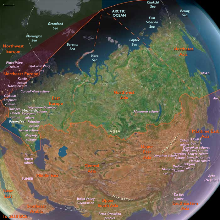
During the late Pleistocene, Northeastern Eurasia extended from the Ural Mountains to the Pacific, encompassing the mammoth-steppe plains of East Europe and Western Siberia, the Altai–Yenisei uplands, and the Amur–Okhotsk–Bering frontier of Northeast Asia.
It was not a single region but a triadic system of worlds:
-
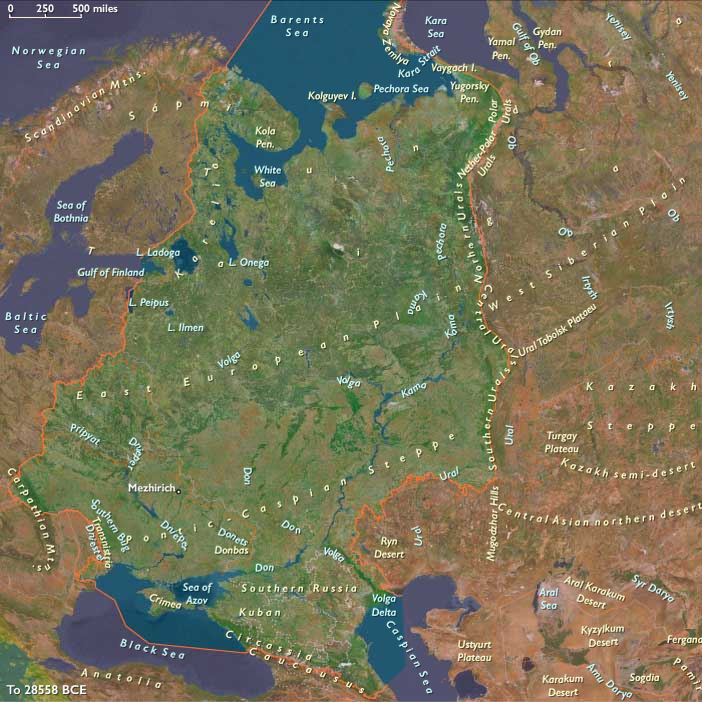
East Europe, the western steppe edge, framed by the Don, Dnieper, and Oka valleys — a land of loess terraces and braided rivers supporting dense megafaunal herds.
-
Northwest Asia, the Siberian interior, from the Urals through the Ob–Irtysh–Yenisei corridor to the Altai, where glacial basins and intermontane valleys served as refugia amid vast permafrost plains.
-
Northeast Asia, the Pacific rim and Beringian shelf, where tundra-steppe met coastal polynyas, bridging the continents long before human migration reached the New World.
Across these subregions, the environment graded from continental aridity in the west to maritime cold along the Pacific — a spectrum of adaptation that tied Eurasia together along its northern rim.
Climate and Environmental Shifts
The interval encompassed alternating Dansgaard–Oeschger warmings and Heinrich cold pulses leading into the Last Glacial Maximum.
-
In East Europe, permafrost advanced to the Dnieper and Don basins; vegetation alternated between steppe grassland and dwarf-shrub tundra.
-
In Northwest Asia, continental cold and aridity dominated; the Ob and Yenisei braided into unstable channels; loess and dust storms swept the forelands of the Urals and Altai.
-
In Northeast Asia, cold was tempered by oceanic moisture. Ice-edge upwellings in the Okhotsk and Bering seas sustained rich marine ecosystems, even as inland basins froze.
Periodic interstadial thaws re-greened the valleys, drawing herds northward and humans with them; stadials drove retreat to riverine refugia.
The result was a dynamic equilibrium of expansion and contraction rather than a single glacial standstill.
Lifeways and Settlement Patterns
All three worlds supported high-latitude foraging economies built on mobility, storage, and memory of place.
-
In East Europe, loess-terrace camps overlooked reindeer and mammoth migration corridors. Semi-recurrent bases at Kostenki, Sungir, and along the Dnieper combined hunting, butchery, and craft production.
-
In Northwest Asia, the Altai foothills and Minusinsk Basin hosted recurrent winter shelters, while open Ob–Yenisei valleys served for summer mammoth and bison hunts.
-
In Northeast Asia, river-mouth camps and coastal flats supported dual economies of inland big-game and maritime sealing and fishing. Seasonal movements linked river confluences, upland passes, and shelf-edge hunting grounds.
Each subregion achieved local stability through broad prey portfolios and cyclical mobility tuned to glacial rhythms.
Technology and Material Culture
A shared Upper Paleolithic technological grammar spanned the entire northern corridor:
-
Blade and microblade industries, adapted to portable composite weapons, formed the technological backbone from the Don to the Anadyr.
-
Bone, antler, and ivory were fashioned into points, awls, harpoons, and eyed needles — evidence for tailored fur clothing and cold-weather dwellings.
-
Obsidian sources in the Altai and Kamchatka and flint quarries in the Don basin anchored far-flung exchange networks.
-
Personal adornment — beads of tooth, ivory, shell, and amber — and ochre burials underscored enduring symbolic systems linking the Eurasian north to the rest of the Upper Paleolithic world.
The breadth of these parallels reveals not isolation but interoperability across extreme distance.
Movement and Interaction Corridors
Northeastern Eurasia was defined by movement — the continual negotiation between ice, water, and wind.
-
The Steppe–River Network: Don–Volga–Ural–Ob–Yenisei channels allowed seasonal following of herds and diffusion of tool types and ornaments.
-
The Altai–Mongolia Crossroads: A mountainous hinge connecting western and eastern populations, where genetic and cultural exchanges mixed Siberian and East Asian lineages.
-
The Amur–Okhotsk–Bering Rim: Shelf and river corridors provided both overland and coastal pathways toward Beringia, the eventual gateway to the Americas.
These arteries made the northern fringe not an end of settlement but a conveyor of innovation and populationbetween continents.
Cultural and Symbolic Expressions
Symbolic behavior mirrored subsistence breadth.
Engraved bones, ivory figurines, and ochred burials appear in all three subregions, expressing a shared spiritual engagement with animals and ancestors.
Altai and Don sites yield portable art and ivory figures, while the Amur and Lena valleys preserve carved bone and antler motifs of reindeer and mammoth.
Fire-ringed hearths and ritual hearth renewals suggest continuity of place and group identity across generations.
In these expressions, the northern peoples joined the global Upper Paleolithic symbolic sphere while imprinting it with an Arctic signature of endurance and cyclical return.
Environmental Adaptation and Resilience
Resilience depended on technological insulation, ecological diversity, and social connectivity.
Fur clothing, hide shelters, and stored fuel allowed wintering at 60–70° N; seasonal migration between coast, river, and plateau distributed risk; and wide alliance networks permitted exchange of mates, materials, and knowledge across immense ranges.
When one valley froze, another thawed — and people already knew the way.
Genetic and Linguistic Legacy
Populations rooted in this corridor carried the genetic foundations of later Arctic and Beringian peoples.
From East Europe through the Altai to the Amur, gene flow linked Eurasia’s west and east, seeding the ancestry of the First Americans and shaping linguistic substrates later echoed in circumpolar families.
Northeastern Eurasia thus became the cradle of the circumpolar continuum — a trans-Beringian cultural ecology that would persist for tens of millennia.
Transition Toward the Last Glacial Maximum
By 28,578 BCE, ice sheets and permafrost deepened, narrowing the habitable band to river valleys and steppe oases.
Yet humans remained throughout, their territories contracting but not vanishing.
The East European plains anchored the west, the Altai–Yenisei belt sustained the interior, and the Amur–Bering coast reached outward toward a new continent.
Northeastern Eurasia therefore stands as a model of The Twelve Worlds principle: its subregions were self-contained in ecology yet outward-looking in connection, bound less by shared geography than by the long, unbroken thread of movement — the first great northern highway of the human story.
Topics
Commodoties
Subjects
Regions
Subregions

Years: 49293BCE - 28578BCE
Topics
Commodoties
Subjects
Regions
Subregions