Nearly twenty-eight hundred Palatine German emigrants in …
Years: 1710 - 1710
Nearly twenty-eight hundred Palatine German emigrants in the summer of 1710 are transported in ten ships by Queen Anne's government to New York, the largest single group of immigrants before the Revolutionary War.
By comparison, Manhattan at this time has only six thousand people.
Because of their refugee status and weakened condition, as well as shipboard diseases, they have a high rate of fatality.
Another three hundred-some Palatines make it to the Carolinas.
The Germans are employed initially in the production of naval stores along the Hudson River near Peekskill.
Settlement on the east side (East Camp) of the Hudson River is accomplished as a result of Governor Hunter's negotiations with Robert Livingston, who owns Livingston Manor in what is now Columbia County, New York. (This is not the town now known as Livingston Manor on the west side of the Hudson River).
Livingston is anxious to have his lands developed.
The Livingstons will benefit for many years from the revenues they receive as a result of this business venture.
West Camp, on the other hand, is located on land the Crown had recently "repossessed" as an "extravagant grant."
Pastors from both Lutheran and Reformed churches will quickly begin to serve the camps and create extensive records of these early settlers long before the state of New York is established or keeps records.
Locations
People
Groups
- Germans
- New York, Province of (English Colony)
- England, (Orange and Stewart) Kingdom of
- German Palatines
Topics
Commodoties
Subjects
Regions
Subregions
Related Events
Filter results
Showing 10 events out of 24 total
Northeastern North America (1828–1971 CE)
Industrial Heartlands, Atlantic Gateways, and Cold War Crossroads
Geography & Environmental Context
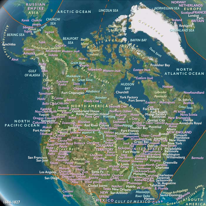
Northeastern North America includes all territory east of 110°W, except the lands belonging to Gulf and Western North America. This encompasses the Great Lakes basin, the St. Lawrence River corridor, Hudson Bay and Labrador, Newfoundland, Greenland, the Arctic, the Maritime provinces, and the Atlantic seaboard from New England through Virginia, the Carolinas, and most of Georgia. It also contains the Mississippi Valley north of Illinois’ Little Egypt and the Upper Missouri above the Iowa–Nebraska crossing, as well as northeast Alabama, central and eastern Tennessee, and nearly all of Kentucky.
Anchors included the Great Lakes–St. Lawrence corridor, the Appalachian piedmont, Hudson Bay, the Greenland ice sheet, and the Atlantic coastal plain. This was a region of forests and prairies, industrializing river valleys, and Arctic margins increasingly integrated into continental and global networks.
Climate & Environmental Shifts
The 19th century saw the close of the Little Ice Age, with harsh winters persisting into the mid-century before gradual warming by the 20th. The Great Lakes and St. Lawrence valleys endured blizzards and drought cycles. Greenland’s sea ice remained extensive until the early 20th century, then retreated. Atlantic storms reshaped seaboards, while the Dust Bowl’s fringes touched the upper Mississippi Valley. By the mid-20th century, industrial pollution, damming, and deforestation altered rivers and lakes. Warmer conditions opened some Arctic navigation and enabled agricultural expansion on the prairies.
Subsistence & Settlement
-
United States:
-
The eastern seaboard and interior transformed into an industrial core. Wheat, corn, and cotton farming underpinned rural life, while cities like New York, Boston, Philadelphia, Cleveland, Detroit, and Chicago grew as manufacturing giants.
-
Immigration from Europe swelled urban populations; African Americans migrated north in the Great Migration, reshaping cities.
-
-
Canada:
-
Confederation (1867) bound Ontario, Quebec, and the Maritimes; later provinces joined as prairie farming expanded through the Great Lakes–St. Lawrence corridor.
-
Industrial centers like Montreal, Toronto, and Halifax grew rapidly.
-
-
Greenland:
-
Inuit sustained hunting and fishing lifeways; Danish colonial administrators introduced trade posts, missions, and modernization projects.
-
Sealing and cod fisheries dominated, while U.S. bases after WWII tied Greenland into Cold War strategy.
-
-
Indigenous nations: Though often displaced or confined, Native communities persisted through fur trade, wage labor, and mixed economies, maintaining ceremonies and oral traditions despite assimilationist pressures.
Technology & Material Culture
-
Industrialization: Steamships, canals (Erie, Welland), and railroads structured 19th-century movement. Iron, coal, and later oil fueled factories; by the 20th century, automobiles, telephones, and electricity reshaped life.
-
Great Lakes: Shipyards, steel mills, and automotive industries (Detroit) symbolized industrial power.
-
Urban landscapes: Skyscrapers rose in New York and Chicago; monumental civic buildings reflected republican ideals.
-
Inuit technology: umiaks, sledges, and skin clothing persisted, gradually blending with rifles, aluminum boats, and modern textiles.
Movement & Interaction Corridors
-
St. Lawrence–Great Lakes corridor: Lifeline for grain, timber, coal, and manufactured goods; the St. Lawrence Seaway (1959) opened direct passage to the Atlantic.
-
Atlantic ports: New York, Boston, Halifax, and Norfolk became hubs for immigration, finance, and shipping.
-
Hudson Bay Company posts: Continued fur trading into the 19th century, later giving way to mining and forestry.
-
Greenland: Danish trade routes and, later, U.S. airbases connected Inuit settlements to North Atlantic geopolitics.
-
Railroads and highways: Linked Atlantic and Great Lakes cities to prairies; by mid-20th century, interstate highways and air travel reinforced northeastern dominance.
Cultural & Symbolic Expressions
-
Indigenous resilience: Powwows, art, and oral tradition preserved identity despite reservation and assimilation policies.
-
United States: Republican ideals, frontier and industrial myths, and later consumer democracy shaped identity; jazz, blues, and rock emerged from northeastern cities.
-
Canada: Bilingual (French-English) traditions, maritime folklore, and Indigenous storytelling marked cultural life.
-
Greenland Inuit: Shamanic traditions blended with Lutheranism; drum dances, carvings, and hunting songs remained central.
-
Symbols of modernity: factories, bridges, skyscrapers, and lighthouses expressed progress and connection to the Atlantic.
Environmental Adaptation & Resilience
-
Farmers expanded into prairies with mechanization and fertilizers, though soil depletion and dust crises highlighted limits.
-
Industrial growth degraded landscapes with smoke and effluent; the Great Lakes suffered heavy pollution by mid-20th century.
-
Fisheries collapsed in parts of the Atlantic; conservation movements responded with national parks and wildlife protections.
-
Inuit adapted to retreating sea ice by diversifying hunting practices and incorporating modern tools.
Political & Military Shocks
-
United States: Civil War (1861–65) ended slavery and reshaped the Union; World Wars I & II propelled it to superpower status.
-
Canada: Confederation (1867) and expansion west built a new nation within the British Empire; by 1931 (Statute of Westminster), Canada achieved near-full sovereignty.
-
Greenland: Remained a Danish colony until 1953, when it became an autonomous province; Cold War airbases underscored its strategic value.
-
Indigenous dispossession: Treaties, removals, and boarding schools stripped communities of land and autonomy, though resistance and renewal persisted.
Transition
By 1971 CE, Northeastern North America had become an industrial heartland and Atlantic hub. The United States emerged as a global superpower anchored in its eastern cities; Canada consolidated as a bilingual, industrial nation; and Greenland shifted into Cold War geopolitics under Danish and U.S. oversight. Indigenous nations endured profound losses but maintained cultural resilience. This subregion had become both the engine of the Atlantic world and a critical stage for modern geopolitics, carrying deep ecological and cultural legacies into the late 20th century.
European-American settlers press the U.S. government to make more land available west of the Mississippi River for white development.
In 1846 Big Elk makes an illegal treaty allowing a large group of Mormons to settle on Omaha land for a period; he hopes to gain some protection from competing natives by their guns, but the new settlers will cut deeply into the game and wood resources of the area during the two years they are here.
They retain the Oto Reservation along the Big Blue River on the present Kansas-Nebraska border.
They struggle to adapt to reservation life.
Kansas, erroneously described in 1806 by the explorer Zebulon M. Pike as the “great American Desert”, had been thoroughly explored during the first half of the 19th century, but westward-bound settlers and miners had passed through it without staying.
Sparsely settled by Euramericans, principally antislavery New Englanders of Anglo-Saxon stock, the region is home to five Amerindian nations as well as twenty tribes that the U.S. government has relocated to the territory.
With the passage of the Kansas-Nebraska Act of 1854, Leavenworth, first settled in 1827 by Colonel Henry H. Leavenworth to protect travelers on the Santa Fe Trail, becomes the territorial capital of Kansas; Andrew Reeder is the first territorial governor.
The rush to populate the new territory begins, and Kansas becomes a major breeding ground for the sectional conflict as North and South each attempt to send the most settlers into the new territory.
The Kansas-Nebraska Act of 1854 creates two territorial governments designed to ease the construction of the Central Pacific Railroad, itself a compromise between the anti-slavery forces who favor a Northern Pacific Line and the South’s insistence on a Southern Pacific route (which results in the Gadsden Purchase).
To gain the necessary support, the Kansas-Nebraska legislation means allowing slavery into both territories.
Anti-slavery northerners pour in to settle Kansas, but pro-slavery thugs from Missouri take over the polls, enabling the passage of a state constitution allowing slavery.
Terrorist activities escalate on both sides as the constitution awaits ratification.
President James Buchanan, in an attempt to maintain the Union, approves the constitution, as does the Senate, but the House links its approval to a favorable referendum.
The mixed-race Omaha-French man is bilingual and also works as a trader.
His mother was Omaha; his father French Canadian.
In January 1854 he acts as interpreter during the agent James M. Gatewood's negotiations for land cessions with sixty Omaha leaders and elders, who sit in council at Bellevue.
Gatewood has been under pressure by Washington headquarters to achieve a land sale.
The Omaha elders refuse to delegate the negotiations to their gens chiefs, but come to an agreement to sell most of their remaining lands west of the Missouri to the United States.
Competing interests may be shown by the draft treaty containing provisions for payment of tribal debts to the traders Fontenelle, Peter Sarpy, and Louis Saunsouci.
The chiefs at council agree to move from the Bellevue Agency further north, finally choosing the Blackbird Hills, essentially the current reservation in Thurston County, Nebraska.
The sixty men designate seven chiefs to go to Washington, DC for final negotiations along with Gatewood, with Fontenelle to serve as their interpreter.
The chief Iron Eye (Joseph LaFlesche) is among the seven who go to Washington and is considered the last chief of the Omaha under their traditional system.
Logan Fontenelle will serve as their interpreter, and whites will mistakenly believe he is a chief.
Because his father was white, the Omaha never accept him as a member of the tribe, but consider him white.
Although the draft treaty authorizes the seven chiefs to make only "slight alterations," the government officials will force major changes when they meet, taking out the payments to the traders and reducing the total value of annuities from $1,200,000 to $84,000, to be spread over the years until 1895.
It reserves the right to decide on distribution between cash and goods for the annuities.
The Republican Party will quickly become the principal opposition to the dominant Democratic Party and the briefly popular Know Nothing Party.
The main cause is opposition to the Kansas–Nebraska Act, which repeals the Missouri Compromise by which slavery is kept out of Kansas.
The Northern Republicans see the expansion of slavery as a great evil.
The first public meeting of the general anti-Nebraska movement, at which the name Republican is suggested for a new anti-slavery party, is held in a schoolhouse in Ripon, Wisconsin.
The name is partly chosen to pay homage to Thomas Jefferson's Republican Party.
The Kansas–Nebraska Act also establishes that these two new Territories will decide either to allow or disallow slavery, depending on balloting by their residents (these areas would have been strictly "free territory" under the Missouri Compromise, which allowed slavery in the State of Missouri but disallowed it in any other new state north of latitude 36° 30', which forms most of the southern boundary of Missouri.
This prohibition of slavery extends all the way from the western boundary of Missouri to the Pacific Ocean).
Kansas, passed to the United States as a part of the Louisiana Purchase in 1803, has since 1830 been in an area designated as Indian Territory, where the U.S. government has relocated tribes who occupy lands wanted by Euramericans.
On May 30, 1854, the U.S. Congress passes Senator Stephen A. Douglas's Kansas-Nebraska Act, which repeals the prohibition of slavery north of latitude 36°0' (established in the Missouri Compromise of 1820).
Kansas is organized as a territory, including most of the eastern half of present-day Colorado.
In a break with precedent, Congress allows the territory's citizens to determine the slavery question for themselves.
This most crucial application of the doctrine of “popular sovereignty” (called Squatter Sovereignty by its detractors) makes slavery legally possible in a vast new area.
The earliest meetings of people who may be identified as Republicans had been held in October 1853 in Exeter, New Hampshire, and in May 1854 in Ripon, Wisconsin, but the convention that formally launches the party is held at Jackson when a group of former Whigs, Democrats, and Free-Soilers adopt the name Republican.
The name appeals to those who recall Jeffersonian “republicanism” and generally place the national interest above sectional interest and above states' rights.
The party's founders, having specifically created it as an engine to oppose the westward extension of slavery, are firmly linked in common opposition to slavery, particularly to the recent passage of the Kansas-Nebraska Act of 1854, which will potentially extend slavery into these newly created territories.
During the summer of 1856, native raiders attack travelers along the Emigrant Trail near Fort Kearny.
In retaliation, the U.S. Cavalry attacks a Cheyenne camp on Grand Island in Nebraska.
They kill ten Cheyenne warriors and wound eight or more.
Cheyenne parties attack at least three emigrant settler parties before returning to the Republican River.
Years: 1710 - 1710
Locations
People
Groups
- Germans
- New York, Province of (English Colony)
- England, (Orange and Stewart) Kingdom of
- German Palatines
