East Africa (28,577 – 7,822 BCE): Late …
Years: 28577BCE - 7822BCE
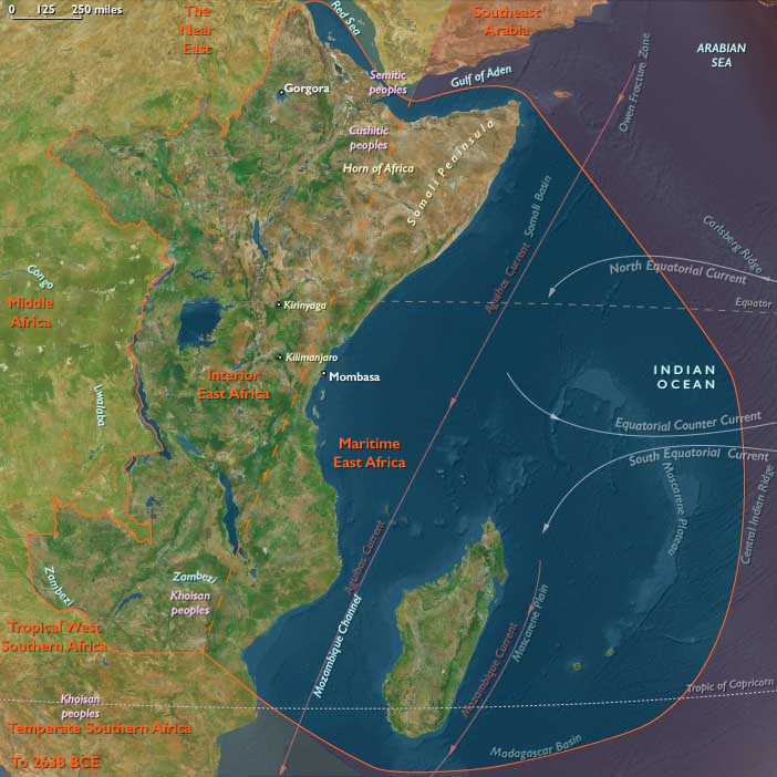
East Africa (28,577 – 7,822 BCE): Late Pleistocene–Early Holocene — Rising Seas, Lake Highstands, and Semi-Sedentary Foragers
Geographic & Environmental Context
During the long deglaciation from the Last Glacial Maximum to the Early Holocene, East Africa cohered as a single water-anchored world. Two tightly linked spheres structured lifeways:
-
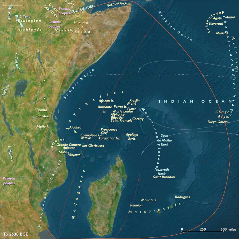
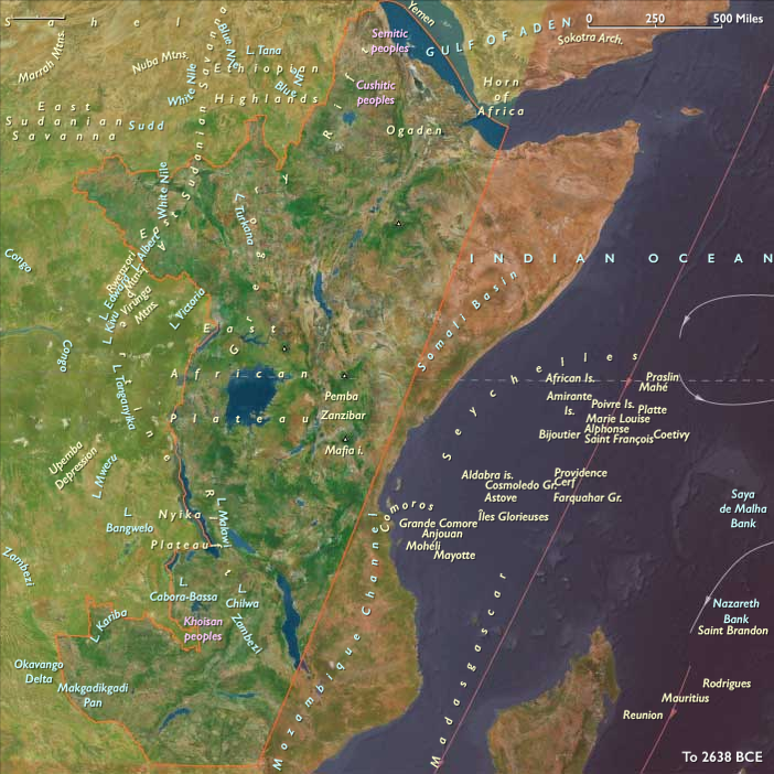
Maritime belt — the Somalia–Kenya–Tanzania–N/central Mozambique littoral and near-shore islands (Lamu–Pate–Mombasa, Zanzibar–Pemba–Mafia, Kilwa Kisiwani–Songo Mnara, the Comoros, with Madagascar, Seychelles, and the Mascarene atolls still unpeopled). Rapid sea-level rise drowned glacial terraces, carving estuaries, embayments, and mangrove belts along newly formed lagoons.
-
Interior belt — the Ethiopian Highlands and Upper Nile–Sudd, the Rift Valley belts and Great Lakes(Victoria, Tanganyika, Malawi), the Rwenzori–Virunga highlands, and the Zambezi corridor. Deglaciation and monsoon rebound drove lake expansions and wetland growth, then contractions during short arid pulses, before Early Holocene stabilization.
Together, these belts formed one hydrological engine: headwaters to lakes, lakes to rivers, rivers to estuaries and reef-lined coasts.
Climate & Environmental Shifts
-
Bølling–Allerød (c. 14.7–12.9 ka): Warmer, wetter conditions strengthened the monsoon. Mangroves expanded along the coast; Rift lakes rose; wetlands multiplied.
-
Younger Dryas (c. 12.9–11.7 ka): A brief cool–dry pulse. Mangrove margins retreated and some reefs were exposed; lake levels fell, narrowing floodplains and concentrating foragers at dependable springs and outlets.
-
Early Holocene (after 11.7 ka): Renewed warmth and moisture. Sea level continued to rise, maturing lagoons and estuaries; Great Lakes highstands returned; highland forests spread.
This cadence favored flexible rounds keyed to flood pulses, fish runs, and coastal productivity.
Subsistence & Settlement
A broad-spectrum, water-anchored economy matured across both spheres:
-
Coast & lagoons: Semisedentary shell-midden villages developed around Lamu–Zanzibar–Kilwa embayments. Diets leaned on shellfish, reef and estuarine fish, dugong, and turtle, with seasonal waterfowl. Camps lengthened stays at lagoon mouths and mangrove creeks as sea level stabilized.
-
Great Lakes & highlands: Lake-shore hamlets intensified fishing with barbed harpoons and nets, paired with hunting of reduncine antelopes, buffalo, and giraffe on adjacent plains. In the Ethiopian Highlands, repeated occupations near springs and passes combined small-game hunts with gathering of wild tubers, seeds, and fruits. The Upper Nile–Sudd supported fish-and-fowl economies anchored to levees and backwaters.
Across both spheres, settlements repeatedly reoccupied dune bars, levees, outlet fans, rock shelters, and spring mounds, creating place-memory landscapes and an incipient rhythm of semisedentism without architecture.
Technology & Material Culture
Toolkits remained light, portable, and tuned to water:
-
Microlithic industries (backed bladelets, geometric segments) for composite arrows and spears.
-
Fishing gear: bone harpoons (often barbed), gorges, net sinkers, basket traps, and weir elements.
-
Processing tools: grindstones for seeds and geophytes; shell scrapers for fish and hide work.
-
Watercraft: evidence for dugouts/rafts in sheltered estuaries and along quiet river reaches.
-
Ornaments & pigments: shell beads and red ochre in domestic and mortuary contexts; bead strings curated at long-used nodes.
Movement & Interaction Corridors
Braided corridors integrated coast and interior:
-
Coastal cabotage stitched lagoon to lagoon along the Horn → Kenya → Tanzania rim, moving fish, shell, salt, and fibers.
-
Victoria–Nile axis linked Great Lakes fishing communities northward to the Upper Nile and, ultimately, Egypt.
-
Highland passes connected Ethiopian uplands to Rift escarpments and the Red Sea margin.
-
Zambezi–Chobe–Caprivi and feeder rivers circulated people and materials across wetlands and savannas.
These redundancies turned late floods, short droughts, or storm seasons into manageable detours.
Cultural & Symbolic Expressions
Waterfront places became ritual topographies:
-
Shell middens functioned as ancestral markers at coastal landings; first-fish and turtle-season feasts renewed access rules to weirs and groves.
-
Lake-margin burials with ochre, beads, and curated tools anchored claims to beaches, outlets, and fishing grounds.
-
In the Ethiopian–Sudanese arc, early rock art (cattle and hunting motifs) and pigment caches appear at springs and pass-shelters, signaling deepening ritual relationships to water and herd landscapes.
Environmental Adaptation & Resilience
Security rested on storage + scheduling + multi-ecozone use:
-
Smoked/dried fish and meats, rendered oils, and roasted seeds bridged lean months and the Younger Dryas setback.
-
Dual estuary–reef strategies on the coast and lake–plain alternation inland spread risk across habitats and seasons.
-
Settlement anchoring at rich nodes (lagoons, outlets, springs) with mobile spokes to uplands and plains balanced permanence and flexibility.
Long-Term Significance
By 7,822 BCE, East Africa had stabilized into a water-anchored forager world: semisedentary shell-midden villages along the monsoon coast and durable lake-shore communities around Great Lakes highstands. The operating code—portfolio subsistence, storage, lagoon/lake anchoring with seasonal mobility, and ritual governance of access—set a resilient foundation for the Early Holocene, foreshadowing later pastoral spread in the highlands and the growth of Indian Ocean exchange along the same monsoon shores.
Topics
Commodoties
Subjects
Regions
Subregions
Years: 28577BCE - 7822BCE
Topics
Commodoties
Subjects
Regions
Subregions