East Africa (1540–1683 CE) Portuguese Hegemony, …
Years: 1540 - 1683
East Africa (1540–1683 CE)
Portuguese Hegemony, Swahili Resilience, and Inland Renaissance
Geography & Environmental Context
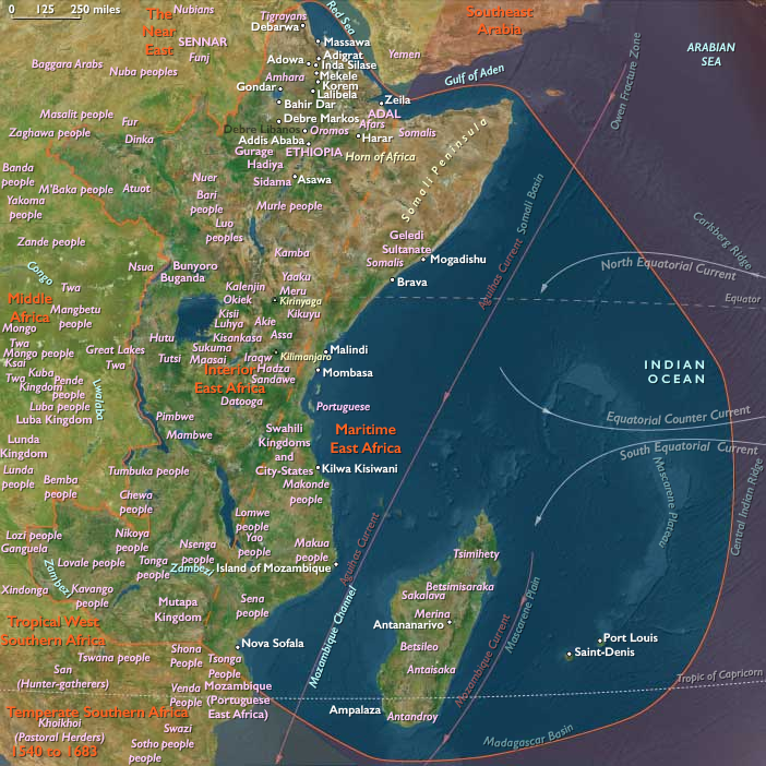
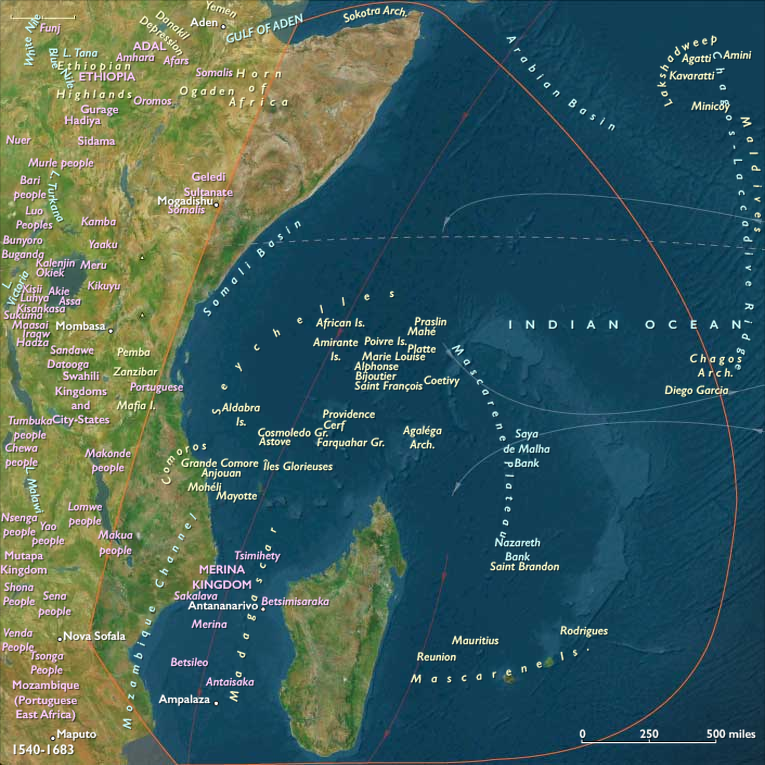
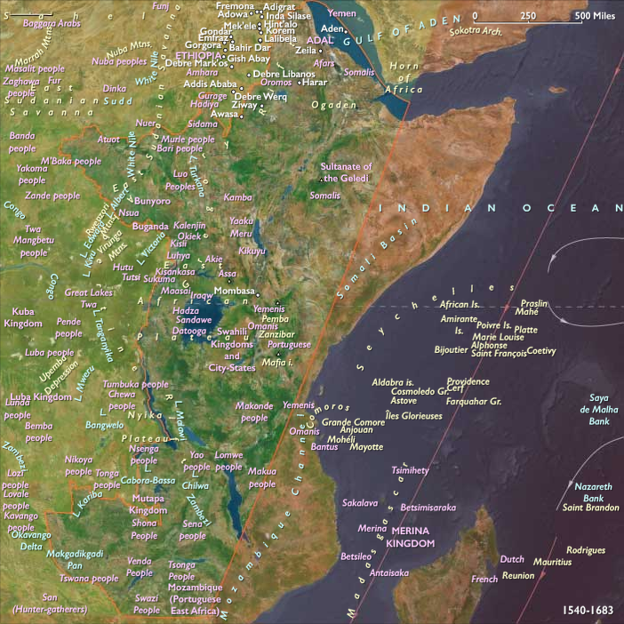
East Africa in this age encompassed the Swahili coast—from Somalia and eastern Ethiopia through Kenya, Tanzania, and northern Mozambique—together with the Comoros, Madagascar, Mauritius, and Seychelles, and the interior highlands and rift corridors of Ethiopia, Uganda, Rwanda, Burundi, Zambia, Malawi, and northern Zimbabwe.
Its landscapes fused coral coasts, mangrove estuaries, and monsoon ports with the high plateaus and lake basins of the Great Rift system. The Little Ice Age continued to modulate rainfall: droughts alternated with flood years, reshaping both coastal rice terraces and inland gardens. Monsoon rhythms governed navigation, while volcanic and seismic pulses stirred the rift valleys. Cyclones battered island settlements from Madagascar to the Comoros, yet seasonal fertility and abundant fisheries sustained growing populations.
Maritime Realms and the Portuguese Intrusion
Swahili Ports under Foreign Shadow
When Portuguese fleets seized Kilwa, Mombasa, and Sofala early in the 16th century, they sought to control the western Indian Ocean spice and gold trade through the cartaz pass system and a chain of stone fortresses. Their Estado da Índia, centered at Goa and Mozambique Island, exacted tolls and tribute from merchants, but never extinguished Swahili autonomy.
Behind coastal battlements, Arabic-script chronicles, coral-stone mosques, and carved doorways attested to a still-vigorous Islamic urban culture. Portuguese garrisons held harbors intermittently; inland caravans carrying ivory, gold, and slaves continued beyond their reach.
Islands and the Western Indian Ocean Network
Across Zanzibar, Pemba, and the Comoros, mixed African–Arab populations sustained orchards of coconut, banana, and rice. Comorian chiefs provisioned Portuguese and Swahili vessels, while dhows carried cattle and captives to Madagascar and back.
On Madagascar, Sakalava kingdoms expanded along the west coast, uniting cattle wealth with maritime raiding and rice exports. Highland farmers perfected terraced irrigation; southern herders endured periodic droughts that drove migration.
Farther east, Mauritius and Seychelles, still uninhabited, entered nautical charts as waypoints for Indian Ocean pilots—a quiet prelude to later colonization.
Cultural Continuity and Exchange
Islam remained the Swahili world’s unifying faith: Friday mosques, Quranic schools, and dhikr rituals marked urban life. Portuguese Catholic missionaries, despite chapels and crosses on the coast, made few conversions. Coral-stone architecture, imported ceramics, and Persianate verse embodied cosmopolitan continuity. On Madagascar, ancestor worship, cattle sacrifice, and tomb architecture symbolized lineage power, while on the Comoros, Islamic feasts and spirit-possession dances intertwined belief and community.
Inland Frontiers and the Age of Reformation
Gunpowder Wars and Highland Renewal
The highlands of Ethiopia and Eritrea reeled under the shock of the Adal–Christian wars. In the 1520s–1540s, Ahmad ibn Ibrahim al-Ghazi (“Gragn”) led matchlock-armed campaigns that nearly destroyed the Solomonic realm. With Portuguese musketeers and cannon, Emperor Gelawdewos repelled Adal’s advance, but the trauma redrew the highland frontiers. Firearms lingered, reshaping warfare and ceremony alike.
In the conflict’s wake, Jesuit missions entered the court; Susenyos’s brief Catholic conversion (1620s) provoked rebellion until Fasilides (r. 1632–1667) restored Orthodoxy and founded Gondar, a royal and artistic capital that re-anchored Christian kingship amid an encroaching Oromo frontier.
Oromo Migrations and the New Pastoral Order
From the mid-16th century, Oromo confederacies, organized through the gadaa age-set system, expanded north and west from the Borana plains. Mounted warriors transformed grazing lands and tributary systems in Shewa, Bale, and Welega, integrating highland cultivators into a wider agro-pastoral world. These migrations reconfigured demography, ecology, and exchange, embedding mobility and negotiation as hallmarks of East African statecraft.
Great Lakes Kingdoms and Plateau Consolidation
Farther south, the interlacustrine plateau—Bunyoro, Buganda, Rwanda, Burundi, and Karagwe—entered a period of political concentration. Banana and plantain gardens, intercropped with beans and yams, supported dense populations; cattle became the metric of tribute and alliance. Royal drums, regnal shrines, and clan patronage structured authority. Along lake margins, canoes ferried iron, fish, and salt between hill capitals and trading ports, binding the plateau to Indian Ocean markets via caravan chains through Tabora and Kilwa.
Southern and Western Extensions
Across the savannas of Zambia, northern Zimbabwe, and Malawi, sorghum and millet cultivation paired with copper and salt exchange. Ironworkers forged tools and spears for farming and defense. Earthwork forts and cattle kraals protected villages from raiding bands as the ivory and slave trades began to filter inland from both coasts.
Technology, Trade & Cultural Synthesis
-
Iron and water were the civilizing engines of the interior: terraced fields, canals, and forges sustained both plow agriculture and royal prestige.
-
Gunpowder and cannon, entering through the Red Sea and Portuguese ports, shifted warfare but remained rare beyond court arsenals.
-
Dhows and canoes connected monsoon harbors with lake fisheries and river basins; cloth, beads, and salt served as currencies binding coast and interior.
-
Art and devotion flourished: Ethiopian painters illuminated saints’ lives; Buganda’s drummers and Rwanda’s court poets celebrated kings and cattle; Swahili calligraphers adorned coral mosques; Sakalava sculptors carved tomb effigies that gazed over coastal plains.
Environmental Adaptation & Resilience
Highlanders maintained church forests as ecological refuges, storing grain in monastic granaries. Plateau farmers relied on perennial banana gardens to steady food supply; fisherfolk smoked and traded fish during drought years. Pastoralists diversified herds, shared wells, and rotated grazing. Along the coasts, Swahili and Malagasy communities balanced horticulture, fishing, and trade, replanting coconut and rice after storms. Kinship networks and ritual feasts redistributed resources, turning reciprocity into resilience.
Power, Conflict, and Transformation
Portuguese domination at sea coincided with inland transformations driven by migration, faith, and trade. At Mombasa and Kilwa, cannon imposed tribute; in Gondar, churches rose from the ruins of war; on Lake Victoria’s shores, kings beat royal drums to summon their subjects. Caravans and monsoons wove these worlds together, carrying cloth, ivory, salt, and stories across ecological and cultural divides.
Transition (to 1683 CE)
By 1683, East Africa had become a deeply interconnected yet fragmented realm.
-
On the coast, Portuguese forts punctuated Swahili autonomy, but Islam, trade, and language endured.
-
In the interior, the highlands recovered under Orthodox monarchs, while Oromo pastoral republics and Great Lakes kingdoms matured into durable polities.
-
Madagascar and the islands joined the Indian Ocean economy through cattle, rice, and raiding; Mauritius and Seychelles awaited colonization.
Across mountains, plains, and seas, African ingenuity outlasted imperial intrusion. The 15th-century world of monsoon merchants had given way to one of shifting sovereignties—Portuguese, Swahili, Oromo, Sakalava, and Solomonic—each adapting to climate, commerce, and the timeless pulse of the monsoon winds.
People
Groups
- Khoisan
- Austronesian peoples
- Bantu peoples
- Arab people
- Omanis
- Somalis
- Madagascar
- Nilotic peoples
- Persian Empire, Sassanid, or Sasanid
- Dutch people
- Merina people
- Swahili people
- Comoro Islands
- Islam
- Antanosy people
- Kilwa Sultanate
- Mecca, Sharifate of
- Ajuran Sultanate
- Portugal, Avizan (Joannine) Kingdom of
- Ottoman Empire
- Merina, Kingdom of
- Netherlands, United Provinces of the (Dutch Republic)
- France, (Bourbon) Kingdom of
- Mauritius, Dutch
Topics
- Colonization of Asia, Portuguese
- Colonization of Asia, Dutch
- Colonization of Asia, French
- Fort Dauphin, Massacre of
Commodoties
Subjects
Regions
Subregions
Related Events
Showing 10 events out of 37475 total
Years: 1540 - 1683
People
Groups
- Khoisan
- Austronesian peoples
- Bantu peoples
- Arab people
- Omanis
- Somalis
- Madagascar
- Nilotic peoples
- Persian Empire, Sassanid, or Sasanid
- Dutch people
- Merina people
- Swahili people
- Comoro Islands
- Islam
- Antanosy people
- Kilwa Sultanate
- Mecca, Sharifate of
- Ajuran Sultanate
- Portugal, Avizan (Joannine) Kingdom of
- Ottoman Empire
- Merina, Kingdom of
- Netherlands, United Provinces of the (Dutch Republic)
- France, (Bourbon) Kingdom of
- Mauritius, Dutch
Topics
- Colonization of Asia, Portuguese
- Colonization of Asia, Dutch
- Colonization of Asia, French
- Fort Dauphin, Massacre of
Commodoties
Subjects
Regions
Subregions