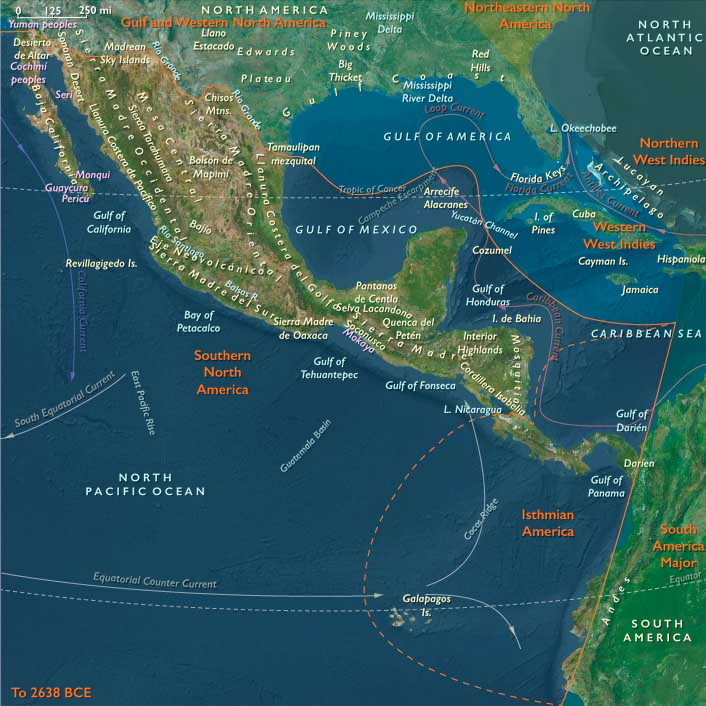
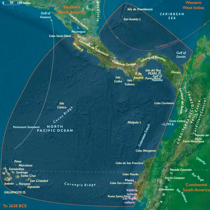
Isthmian America (6,093 to 4,366 BCE) Middle …
Years: 6093BCE - 4366BCE
Isthmian America (6,093 to 4,366 BCE) Middle Holocene — Proto-Horticulture, Canoe Exchange, Cape Polities-in-Embryo.
Geographic & Environmental Context
Isthmian America includes Costa Rica, Panama, Darién (Panama–Colombia), San Andrés Archipelago, Galápagos Islands, and the Ecuadorian Capelands (Cabos Manglares, San Francisco, Pasado, San Lorenzo, Punta Santa Elena; Manta; western Esmeraldas, Manabí, Guayas, Santa Elena).
Anchors: Panama isthmus and Azuero; Darién–Chocó rainforests; Costa Rica Central Valley and Nicoya; San Andrés banks; Galápagos volcanic outliers; Manta–Santa Elena capes and lagoons.
Subsistence & Settlement
-
Tending taro, yam, bananas, palms in Nicob… (analogy) — here: coast slopes & freshwater seeps around Manta–Santa Elena and Nicoya; fisher–forager hamlets semi-permanent.
-
Darién: large seasonal camps on levees; San Andrés: provisioning stop; Galápagos still unpeopled.
Technology & Material Culture
-
Polished adzes; wider pottery use; sewn-plank dugouts in calm Pacific bays.
Movement & Interaction Corridors
-
Canoe caravans ferried dried fish, shells, resins, salt among coast capes; short overland portages across Isthmus.
Cultural & Symbolic Expressions
-
Ancestral canoe cults; ritual landings; capes as sacred thresholds.
Adaptation & Resilience
-
Transported landscapes (tended groves/gardens) stabilized calories in poor years.
Transition
-
Proto-horticultural coast villages & canoe exchange mature, foreshadowing later gold–shell–cotton networks.
Groups
Commodoties
Subjects
Regions
Subregions
Related Events
Filter results
Showing 10 events out of 69156 total
Both Cushitic- and Omotic-speaking peoples collect wild grasses and other plants for thousands of years before they eventually domesticate those they most prefer.
According to linguistic and limited archaeological analyses, plow agriculture based on grain cultivation is established in the drier, grassier parts of the northern highlands by at least several millennia before the Christian era.
Indigenous grasses such as teff and eleusine are the initial domesticates in the Ethiopia region; considerably later, barley and wheat are introduced from Southwest Asia.
The corresponding domesticate in the better watered and heavily forested southern highlands is ensete, a root crop known locally as false banana.
All of these early peoples also keep domesticated animals, including cattle, sheep, goats, and donkeys.
Thus, from the late prehistoric period, agricultural patterns of livelihood are established that are to be characteristic of the region through modern times.
It is the descendants of these peoples and cultures of the Ethiopian region who at various times and places will interact with successive waves of migrants from across the Red Sea.
This interaction begins well before the modern era and will continue through contemporary times.
The Aftermath of the 8.2-Kiloyear Event and the Return to the Atlantic Period (c. 6000 BCE)
As the effects of the 8.2-kiloyear event subsided, climatic conditions in Europe gradually stabilized, returning to those of the Atlantic Period—the warmest and most humid phase of the Holocene. This shift brought warmer temperatures, expanded forests, and increased biodiversity, creating more favorable conditions for early human societies.
Rising Sea Levels and Environmental Transformations
Meanwhile, the global rise in sea levels continued, reshaping coastlines and altering human settlement patterns:
- By 6000 BCE, sea levels had nearly reached their present height, flooding low-lying areas and creating new maritime and riverine environments.
- Formerly habitable regions became submerged, contributing to massive inland flooding in parts of Europe, Asia, and the Americas.
- The flooding of the Persian Gulf and the North Sea basin created modern coastal landscapes, such as the English Channel and the Black Sea's transformation into a larger body of water.
Impact on Human Development
As landscapes evolved, human societies adapted by developing regionally distinct cultures:
- In Europe, denser forests and temperate conditions encouraged permanent settlements, agriculture, and early trade networks.
- In Mesopotamia and the Nile Valley, rising waters contributed to fertile floodplains, paving the way for early irrigation-based civilizations.
- In coastal regions, new marine ecosystems promoted fishing and seafaring traditions, fostering maritime trade and cultural exchanges.
This post-glacial stabilization marked a turning point in human history, as regional differentiation in environmental conditions led to the emergence of diverse social, economic, and technological advancements across the globe.
The Older Peron—a "transgression" in the sense of marine transgression, a period of advancing global sea level—is a period of generally clement and balmy weather conditions that favors plant growth; warm temperatures force a retreat in the glaciers and ice sheets of the global cryosphere; throughout the period, global sea levels are two-and-a-half to four meters (eight to thirteen feet) higher than the twentieth-century average.
The higher sea level lasts for several centuries and erodes coastlines. (Several locations around the world have "Older Peron terraces" along their coasts as a result.)
Some anthropologists, folklorists, and others have linked the ages of the Older Peron transgression and the Neolithic Subpluvial with tales of a "time of plenty" (Golden Age; Garden of Eden) that occur in the legendary backgrounds of many cultures.
Northeastern Eurasia (6,093 – 4,366 BCE): Middle Holocene — Rivers of Salmon, Forests of Memory, and the First Great Pottery Webs
Geographic & Environmental Context
During the Middle Holocene, Northeastern Eurasia—stretching from the Ural Mountains and West Siberian rivers through the Yenisei–Lena basins to the Amur Valley, Okhotsk coast, Sakhalin, Kamchatka, and northern Hokkaidō—was a vast world of taiga, tundra, and riverine abundance.
The Hypsithermal climatic optimum transformed this immense territory into a richly productive mosaic of mixed forest, grass-steppe, and salmon-bearing rivers.
In the west, the Ob–Irtysh and Yenisei basins anchored stable fishing and forest economies; eastward, the Amur and Okhotsk corridors linked river valleys to the Pacific; northward, glacial meltwaters fed chains of lakes and wetlands teeming with life.
These were the northern heartlands of the world’s great forager–fishers, and the first to organize wide ceramic, trade, and symbolic networks that prefigured the coming age of pastoralism and metallurgy farther south.
Climate & Environmental Shifts
The Hypsithermal warm maximum (c. 7000–4000 BCE) brought milder winters, longer growing seasons, and higher precipitation across most of Siberia and the Russian Far East.
-
Permafrost retreated, opening new valleys to vegetation and settlement.
-
Dense taiga forests spread northward, dominated by birch, pine, and larch, while broadleaf trees (oak, elm, linden) colonized the southern basins.
-
Rivers and lakes stabilized, producing predictable salmon and sturgeon runs, as well as flourishing populations of elk, bear, and beaver.
This stable climatic envelope underwrote population growth and increasingly permanent settlement—an ecological balance that would endure for millennia.
Subsistence & Settlement
Northeastern Eurasian societies thrived on diversified, river-centered economies that balanced abundance with mobility.
-
In Northwest Asia (the Ob–Yenisei–Altai region), pit-house villages lined river terraces; fishing intensified with weirs, harpoons, and net traps. Elk and reindeer hunting remained vital, supplemented by nuts and berries.
-
In Northeast Asia (the Amur, Sakhalin, Kamchatka, and Hokkaidō zones), large semi-sedentary river and coastal villages emerged, often rebuilt repeatedly to form deep archaeological layers. Salmon runs, seal rookeries, and nut groves sustained dense populations.
-
Storage technology—ceramic containers, smokehouses, and drying racks—enabled year-round residency in many locales.
-
Dog traction facilitated winter mobility; canoes and rafts made rivers and coasts into highways of exchange.
The result was an unparalleled synthesis: fishing societies as populous and materially rich as early farmers, living by rhythm rather than scarcity.
Technology & Material Culture
This epoch saw the great flowering of pottery and woodworking across the northern world:
-
Pottery spread from the western forest-steppe to the Pacific, diversifying into Narva, Comb Ware, fiber-tempered, and corded-impressed forms. Large storage vessels enabled boiling, fermenting, and preserving fish and nuts.
-
Ground-stone tools—adzes, axes, and chisels—supported extensive carpentry, housebuilding, and canoe production.
-
Harpoons, toggling spearheads, and net weights attest to mastery of aquatic technology.
-
Bone and antler craft achieved aesthetic refinement, producing pendants, figurines, and ceremonial objects.
-
In the east, dugout canoes became standard, while obsidian from Kamchatka and Hokkaidō circulated widely.
Across this immense domain, the pottery horizon became the connective tissue of culture—the material sign of a shared northern world.
Movement & Interaction Corridors
The rivers and coasts of Northeastern Eurasia formed a single network of movement and exchange:
-
The Ob–Yenisei–Lena–Amur trunklines carried pottery styles, exotic stones, and ideas over thousands of kilometers.
-
The Altai–Sayan passes and Ural valleys linked Siberia to the steppes and Central Asia, transmitting tools, pigments, and eventually herd animals.
-
Eastward, the Okhotsk Sea and Amur estuaries functioned as maritime corridors, with the Kuril–Sakhalin–Hokkaidō chain acting as an “island ladder” for shell, obsidian, and cultural traffic.
These waterborne routes united forest, tundra, and coast into one of the world’s first truly transcontinental ecological and cultural systems.
Cultural & Symbolic Expressions
Material abundance nurtured complex symbolic and social traditions:
-
Rock art—especially in the Altai, Yenisei, and Amur regions—depicted elk, reindeer, fish, solar disks, and boats, blending hunting, shamanism, and cosmology.
-
Cemeteries with ochre, pottery, and ornaments mark the earliest formalized mortuary rites across the northern taiga.
-
Feasting middens and shell caches in the Amur and Hokkaidō zones point to social gatherings centered on salmon harvests.
-
Longhouse and pit-house clusters suggest lineage-based settlement, with spiritual ties to ancestral places reinforced through burial and ritual deposition.
These expressions reveal communities already possessing a deep sense of ancestry, landscape, and cyclical time—the spiritual architecture of later northern traditions.
Environmental Adaptation & Resilience
Survival in this vast region depended on balance, storage, and mobility:
-
Food storage (dried fish, rendered oils, and nuts) and seasonal mobility mitigated the risk of failed runs or harsh winters.
-
Multi-resource economies—hunting, fishing, gathering—provided redundancy across ecosystems.
-
Domestic dogs and canoes extended range and flexibility.
-
Settlement clustering along ecotones (forest–river–coast) allowed access to multiple biomes.
These adaptive systems ensured that even in years of climatic stress, human communities remained secure, their resilience rooted in environmental intelligence rather than technological excess.
Long-Term Significance
By 4,366 BCE, Northeastern Eurasia had become a continent of stable, populous, and interconnected foraging societies, its rivers and coasts lined with semi-permanent villages and its pottery traditions spanning thousands of kilometers.
The Ob–Amur cultural continuum foreshadowed later Eurasian steppe–taiga interactions, while the Amur–Hokkaidō corridor anticipated the maritime expansions of the late Neolithic and Bronze Age.
This was the age of rivers and salmon, of vast communication without cities—a world where exchange, artistry, and community thrived without agriculture.
Its enduring legacy was a model of resilient abundance, proving that civilization could begin not only in fields, but also in forests and flowing water.
Northeast Asia (6,093 – 4,366 BCE): Middle Holocene — Big Salmon, Big Villages, and Deepening Pottery Traditions
Geographic and Environmental Context
Northeast Asia includes eastern Siberia east of the Lena River to the Pacific, the Russian Far East (excluding the southern Primorsky/Vladivostok corner), northern Hokkaidō (above its southwestern peninsula), and extreme northeastern Heilongjiang.
-
Anchors: Amur–Ussuri terraces and levees, Okhotsk embayments, Sakhalin lagoons, Kamchatka river mouths, Hokkaidō shell-midden coasts.
Beringian Standstill and the End of a Genetic Configuration
During this interval, a subset of Proto-Amerindian Paleo-Siberians entered a prolonged phase of relative genetic isolation, often referred to as the Beringian standstill. For several millennia, these populations remained largely cut off from other Asian groups.
This isolation allowed for:
-
Independent genetic drift
-
Local adaptation to Arctic and sub-Arctic environments
-
The emergence of distinct phenotypic variation
Importantly, this genetic configuration ceased to exist within Siberia itself soon after this period. While Proto-Amerindian groups moved eastward and eventually into the Americas, Siberia underwent further demographic transformation.
Climate & Environmental Shifts
-
Hypsithermal warm maximum: dense mixed taiga, long ice-free seasons, exceptionally large salmon runs.
Subsistence & Settlement
-
Large pit-house villages on raised river benches; repeated rebuilds created deep cultural layers.
-
Seasonal satellite camps at anadromous fish bottlenecks, seal haul-outs, and berry patches.
Technology & Material Culture
-
Diversified ceramic styles (corded/impressed), larger storage vessels; ground-stone woodworking kit; broad weir/trap systems; refined toggling harpoons.
-
Dugout canoes became routine for transport and net sets; dog traction in winter travel.
Movement & Interaction Corridors
-
Canoe trunklines along the Amur and Okhotsk inner coasts; Kuril–Hokkaidō “island ladder” facilitated obsidian and shell exchange.
Cultural & Symbolic Expressions
-
Longhouse/pit-house clustering hints at lineage districts; feasting middens with prestige shell/bead caches; ochre and grave goods in formal cemeteries.
Environmental Adaptation & Resilience
-
High-capacity storage (smoked/dried salmon, rendered oils) enabled semi-sedentary lifeways; diversified procurement (elk, nuts, waterfowl) hedged against run failure.
Transition
By 4,366 BCE, the region supported durable river–coast village systems and ceramic traditions poised for late Neolithic maritime networking.
Northern North America (6,093 – 4,366 BCE): Middle Holocene — Waterways, Woodcraft, and the Rise of Storage Societies
Geographic & Environmental Context
Northern North America formed a continuous, water-linked world from the Gulf of Alaska and the Fraser–Columbia canyons across the Great Lakes–St. Lawrence interior to the Lower Mississippi and Gulf estuaries, the Great Basin, and nearly all of California.
Mid-Holocene highstands stabilized estuaries, kelp forests, and lagoon systems on both coasts; inland, lake and river complexes matured (Great Lakes, St. Lawrence, Upper Mississippi), while playas and spring-fed wetlands punctuated the Great Basin and desert Southwest. Across this breadth, people organized life around fish rivers, shell shores, and seedlands—a hydrologic continent knitted by canoe, portage, and trail.
Climate & Environmental Shifts
The Hypsithermal warm phase brought long ice-free seasons on the North Pacific, strong but reliable monsoon/westerly regimes in the interior West, and moist, productive summers across the Great Lakes and Northeast.
Periodic interior dry spells reshaped foraging calendars on plateaus and basins, counterbalanced by refugia along major rivers and coasts. Sea levels approached near-modern outlines, locking in tidal flats, eelgrass meadows, and delta silts that sustained fisheries and shellfisheries at scale.
Subsistence & Settlement
A continental portfolio economy matured, with storage at its core:
-
Northwest Pacific & Subarctic coast/plateau: canyon and estuary salmon fisheries supported large pit-house villages inland and substantial coastal house platforms; shellfish management (including clam gardens) and berry-patch tenure increased carrying capacity.
-
Great Lakes–Northeast & Atlantic seaboard: intensified Archaic lifeways combined lake/river fisheries with broad plant use; along Superior, the Old Copper tradition added durable tools to fishing and woodworking; shell-ring and shell-heap communities expanded on the southern Atlantic margins.
-
Gulf & Western North America: along the Lower Mississippi and Gulf estuaries, shell rings and river aggregation cycles grew; in California, island–mainland canoe commutes, fish weirs, and large shell-middens scaled up; in the Southwest and Great Basin, seed-processing economies, agave roasts, rabbit drives, and wetland micro-patch exploitation anchored seasonal rounds.
Everywhere, semi-sedentism deepened: villages clustered at fisheries and wetlands, fanning out to upland hunts and seedlands, then reconverging for curing, smoking, and exchange.
Technology & Material Culture
Toolkit fluency underwrote surplus:
-
Heavy carpentry with standardized ground-stone adzes and chisels; hafted slate knives on outer coasts; composite toggling harpoons for sea mammals.
-
Mass-capture gear—engineered net-weir complexes, fish fences, intertidal traps—paired with dugout canoes and, in some areas, sewn-plank precursors; interior basketry, nets, and cordage flourished.
-
In the Great Lakes, native copper (adzes, awls, points) augmented woodcraft and butchery; across the West, millingstones, lined earth ovens, and roasting pits powered “low-level food production.”
-
Shell and stone beadwork, labrets, bannerstones, and fine lithics circulated as display and exchange valuables.
Movement & Interaction Corridors
Water was the road system:
-
Inside Passage canoe lanes stitched Gulf of Alaska islands to Haida Gwaii and the Fraser–Columbia trunk; inland, obsidian (e.g., Mount Edziza), ochre, and fine lithics moved along plateau rivers.
-
The Great Lakes–St. Lawrence spine moved copper, fish, and crafted goods east–west; Niagara and Fox–Wisconsin–Mississippi routes linked interior basins.
-
The Lower Mississippi and Gulf littoral tied shell-ring peoples to river valleys; westward, Rio Grande–Gila–Salt corridors connected deserts, plateaus, and coasts; California’s Channel and outer coasts ran island–mainland circuits.
These braided routes created redundancy—if a run failed or a drought tightened, another corridor supplied protein, salt, or tools.
Cultural & Symbolic Expressions
Material surplus fed prestige and ceremony:
-
On the North Pacific, feasting middens, shell bead caches, rare lithics, and labrets signal rising lineage prestige tied to weir estates and canoe rights.
-
In the interior and Northeast, mortuary elaboration, copper as status metal, and nascent earthworks mark growing ceremonial integrators.
-
Along the Gulf and Atlantic, shell-ring ritual landscapes codified ancestry at water’s edge.
-
Across the West and Southwest, rock art fluorescence (canyonlands to desert basins) mapped mythic hunts, trance, and water guardians; in wetlands, bog deposits and curated places expressed ancestor presence.
Environmental Adaptation & Resilience
Communities engineered stability through storage, scheduling, and tenure:
-
High-capacity drying/smoking of salmon and marine fats; seed banks from nut mast and grass harvests; oils and dried meats as transportable capital.
-
Territorial tenure over weirs, shell beds, berry grounds, and seed patches enforced sustainable yields and reciprocal access.
-
Diversified procurement—coast + river + upland + desert micro-patch—buffered climate swings; exchange networks redistributed risk.
-
Built features—clam gardens, weirs, trackways, ovens—were niche-engineering that increased productivity without agriculture.
Long-Term Significance
By 4,366 BCE, Northern North America had become a continent of storage-rich, semi-sedentary societies—masters of wood, water, and weirs.
From the salmon strongholds of the Northwest to the copper shores of Superior and the shell-ring estuaries of the Gulf and Atlantic, peoples forged rank-leaning economies, prestigious gift circuits, and durable settlement fabrics without farms or cities.
These Middle Holocene habits—surplus management, engineered ecotones, canoe logistics, and ceremonial redistribution—formed the deep grammar from which later Northwest Coast polities, Woodland earthwork traditions, and Pacific littoral chiefdoms would rise.
Northwestern North America
(6,093 – 4,366 BCE) Middle Holocene — Big Weirs, Big Villages, and Plank-House Precursors
Geographic and Environmental Context
Northwestern North America includes Alaska, western Canada (Alberta, British Columbia, Yukon and Northwest territory and Nunavut west of 110°W) Alaska, Washington State, northern Idaho, and the northwestern portions of Montana, Oregon, and California.
-
Salmon-rich Fraser–Columbia canyons; sheltered Haida Gwaii bays; Cook Inlet–Kenai river mouths.
Climate & Environmental Shifts
-
Hypsithermal warmth: long ice-free seasons, productive kelp forests; periodic interior dry spells managed by river focus.
Subsistence & Settlement
-
Large pit-house villages on the interior plateaus; substantial coastal house platforms; higher population densities at canyon fisheries.
-
Intertidal harvesting scaled up (clam gardens in some locales, shellfish management).
Technology & Material Culture
-
Expanded net-weir complexes; standardized ground-stone adzes and chisels for heavy carpentry; hafted slate knives on outer coasts.
-
Early plank-house forms emerged in some coastal nodes; composite toggling harpoons refined.
Movement & Interaction Corridors
-
Coastwise canoe routes tied island archipelagos; interior riverine exchange in obsidian (e.g., Mount Edziza), ochre, and fine grained lithics.
Cultural & Symbolic Expressions
-
Feasting middens; shell bead caches; display of rare lithics and labrets in some Gulf of Alaska contexts indicate rising prestige economies.
Environmental Adaptation & Resilience
-
High-capacity storage, diversified procurement, and territorial tenure over weirs and berry patches stabilized communities across climate swings.
Transition
By 4,366 BCE, semi-sedentary salmon economies and woodworking fluency set the stage for fully ranked coastal societies.
Polynesia (6,093 – 4,366 BCE): Middle Holocene — Reef Highstands and Wetland Worlds
Geographic & Environmental Context
During the Middle Holocene, Polynesia lay fully within the tropical Pacific’s zone of climatic stability, a realm of volcanic high islands, coral-fringed atolls, and emergent reef terraces that would one day host the most far-flung human oceanic network on Earth.
Its principal sectors—North Polynesia (the Hawaiian Islands chain north of Hawaiʻi Island and Midway Atoll), West Polynesia (from Hawaiʻi Island and Tonga through Samoa, Tuvalu, Tokelau, the Cook Islands, the Society Islands, and the Marquesas), and East Polynesia (the Pitcairn group and Rapa Nui)—shared a geography shaped by rising seas, maturing reefs, and widening lagoons.
A global Hypsithermal warm phase elevated sea levels several meters above modern, drowning coastal flats and converting valley mouths into estuarine embayments and back-reef wetlands. Barrier reefs stabilized into continuous arcs; headlands were planed by surf; and new island shelves accumulated sand and coralline rubble that would, millennia later, become settlement plains, loʻi fields, and canoe landings.
Climate & Environmental Shifts
The Middle Holocene brought warm, humid stability punctuated by episodic extremes.
Trade-wind systems strengthened, but Kona-type storms occasionally brought heavy rainfall and flash floods to leeward coasts.
Sea-surface temperatures across the equatorial Pacific were slightly higher than today; ENSO variability remained subdued, maintaining predictably wet windward slopes and calmer leeward seasons.
Reef productivity surged as carbonate accretion kept pace with sea-level rise, while newly flooded coastal depressions matured into perennial wetland complexes of reeds, sedges, and brackish pools.
Biota & Baseline Ecology (Before Human Arrival)
No humans yet inhabited these islands, but ecological succession reached a remarkable equilibrium.
-
Back-reef lagoons and estuaries teemed with mullet, milkfish, gobies, prawns, and mollusks.
-
Dune–strand vegetation—Scaevola, Heliotropium, pandanus, and grasses—anchored beaches against the swell.
-
Montane forests of Metrosideros, Cheirodendron, and tree ferns blanketed the volcanic uplands of the high islands.
-
Seabird rookeries flourished on outer islets and atolls, their guano fertilizing leeward flats and enriching nearshore reefs.
-
In East Polynesia, the young volcanic soils of Rapa Nui and the Pitcairn group supported early colonization by ferns, mosses, and coastal scrub, forming self-sustaining nutrient cycles long before human arrival.
The result was a ridge-to-reef continuum—mountain cloud forest, mid-slope woodland, coastal wetland, reef crest, and open ocean—all functioning in dynamic balance.
Geomorphological Processes and Marine Systems
Across the Polynesian arc, reef highstands defined this era.
Raised coral terraces ringed older islands; back-reef ponds became permanent lagoons; and valley mouth wetlands expanded behind natural barrier bars.
Sediment from intensified rainfall and vegetation expansion enriched lagoons with fine silts, building natural levees later ideal for agriculture.
The alignment of tidal channels, reef passes, and sand spits fixed the geographic templates for the fishponds, irrigated taro basins, and canoe channels that would appear millennia later.
Movement & Interaction Corridors (of Nature, Not Yet of Humans)
Though human navigation had not yet reached Polynesia, the Pacific’s biological highways were already in motion.
Pelagic fish, marine turtles, and migratory seabirds linked these archipelagos ecologically; floating pumice, driftwood, and seeds rode trans-oceanic currents between the Marquesas, Tuamotus, and Hawaiʻian waters, maintaining genetic exchange among reef and shoreline species.
The same predictable wind and current systems that structured these movements—the trades, the westerlies, and the counter-equatorial flow—would later serve as the navigational framework for human voyagers.
Environmental Adaptation & Resilience
These mid-Holocene island ecosystems demonstrated extraordinary resilience.
When storm surges breached spits or hurricanes leveled strand vegetation, rapid recolonization by pioneer plantsrestored dunes within a few seasons.
Reefs self-repaired through coral regrowth, while inland wetlands re-established drainage after flood scouring.
Interlinked food webs—from seabirds to reef fish to mangrove detritivores—created ecological redundancy that stabilized productivity through climatic oscillations.
Long-Term Significance
By 4,366 BCE, Polynesia had achieved its modern physiographic and ecological foundations.
Sea-level highstands had sculpted enduring lagoon and wetland systems; volcanic slopes and reef platforms had matured into stable, fertile environments.
Though unpeopled, the region already embodied the structural harmony—ridge-to-reef integration, lagoon fertility, and predictable marine corridors—that would later underlie the success of Polynesian agriculture, aquaculture, and navigation.
In these centuries, the ocean prepared its own stage: reef, tide, and wind composing the geography of future voyaging and settlement.
North Polynesia (6,093 – 4,366 BCE): Middle Holocene — Reef Highstands and Coastal Wetland Expansion
Geographic & Environmental Context
North Polynesia includes the Hawaiian Islands chain except Hawaiʻi Island (the Big Island) — principally Oʻahu, Maui, Kauaʻi, Molokaʻi, Lānaʻi, Niʻihau — plus Midway Atoll.
-
Anchors: Leeward Oʻahu pocket beaches; Maui Nui bay-head deltas; Kauaʻi–Niʻihau leeward limestone benches; Midway lagoon passes.
Climate & Environmental Shifts
-
Hypsithermal period: modest sea-level highstand created wide back-reef ponds and wetlands; episodic droughts alternated with Kona-storm winters.
Biota & Baseline Ecology (No Human Presence)
-
Estuarine fish (mullet, milkfish) and invertebrates flourished in calm lagoons; freshwater prawns and gobies occupied stream mouths.
-
Dune–strand flora stabilized shorelines; seabirds remained abundant roosting on outer islets and atolls.
Long-Term Significance
Coastal wetlands and back-reef ponds that later become loʻi (taro pondfields) and fishpond basins reached mature form.
West Polynesia (6,093 – 4,366 BCE): Middle Holocene — Highstand Wetlands, Reef Terraces, and Coastal Stability
Geographic & Environmental Context
West Polynesia includes Hawaiʻi Island (the Big Island); Tonga (Tongatapu, Haʻapai, Vavaʻu); Samoa (Savaiʻi, Upolu, Tutuila/Manuʻa); Tuvalu and Tokelau (low atolls); the Cook Islands (Rarotonga, Aitutaki, Mangaia, etc.); Society Islands (Raiatea–Tahiti–Moʻorea–Bora Bora); and the Marquesas (Nuku Hiva, Hiva Oa).
-
Anchors: Tongatapu–Haʻapai sheltered lagoons; Savaiʻi–Upolu bay heads; Tahiti–Raiatea reef passages; Rarotonga–Aitutaki leeward basins; Marquesan deep embayments; Tuvalu–Tokelau rim ponds.
Climate & Environmental Shifts
-
Hypsithermal highstand: modestly higher sea level creates extensive back-reef ponds and estuarine wetlands; occasional Kona-style storms rework spits.
Biota & Baseline (No Human Presence)
-
Estuarine fish/invertebrates boom; freshwater gobies/shrimps occupy streams; coastal strand and pandanus forests stabilize beaches.
Long-Term Significance
Coastal geomorphology reaches near-modern equilibrium—perfect templates for fishponds, irrigated taro fields, and canoe landings.
Years: 6093BCE - 4366BCE
Groups
Commodoties
Subjects
Regions
Subregions