Middle America (1396–1539 CE) Isthmian Crossroads, …
Years: 1396 - 1539
Middle America (1396–1539 CE)
Isthmian Crossroads, Mesoamerican States, and the First Atlantic Conquests
Geographic Definition of Middle America
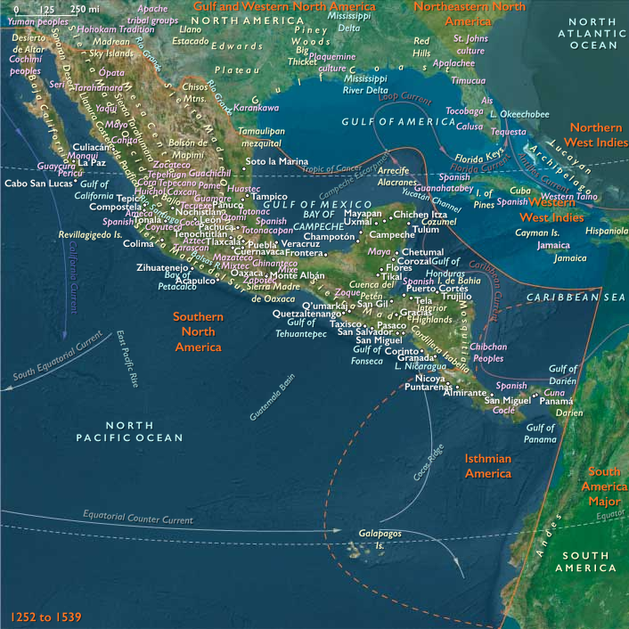
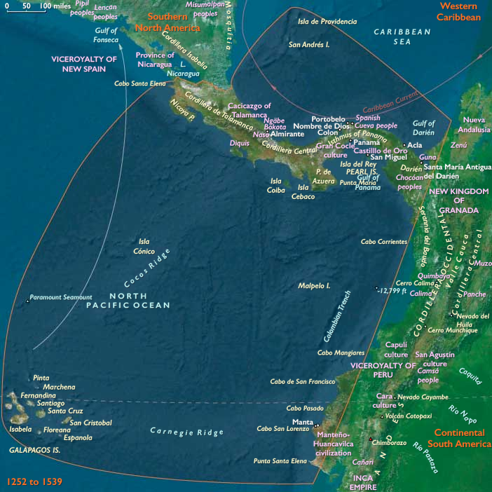
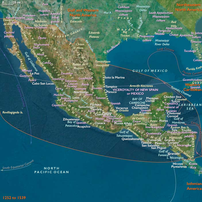
Middle America encompasses Isthmanian America—Costa Rica, Panama, the San Andrés Archipelago, the Galápagos Islands, and the Darién of Colombia with the Cape lands of Ecuador—and Southern North America—Mexico, Guatemala, Belize, Honduras, El Salvador, and Nicaragua.
Anchors include the Valley of Mexico, the Yucatán Peninsula, the Chiapas–Guatemalan cordillera, the Cordillera Central of Panama–Costa Rica, the Darién Gap, the Gulf of Panama, and the Pacific outliers of the Galápagos. Bounded by South America Major to the south (beginning beyond the Darién and Ecuador’s cape lands), this narrow continental hinge joined the Caribbean and Pacific, making it one of the most strategic corridors in the Americas.
Geography & Environmental Framework
The early Little Ice Age modestly cooled highlands while preserving tropical rainfall regimes.
Caribbean slopes remained humid; Pacific faces saw sharper dry seasons. Highland basins—from the Valley of Mexico to Antigua Guatemala—supported dense populations, while lowland coasts and floodplains favored cacao groves, salt pans, and fishing settlements. Offshore, the Galápagos oscillated with El Niño, their upwellings feeding seabird and turtle populations even in the absence of permanent human settlement.
Climate & Environmental Shifts
-
Highlands: Shorter growing seasons and frost risk in the Basin of Mexico and Guatemalan plateaus tested maize at altitude, but terrace and irrigation systems buffered yields.
-
Lowlands: Periodic drought affected Maya lowlands; hurricanes struck Caribbean coasts episodically; torrential rains inundated the Darién and Pacific estuaries.
-
Galápagos: El Niño brought rainfall pulses and disrupted marine upwelling cycles, altering rookery success.
Despite variability, societies mitigated risk through waterworks, multicropping, storage, and exchange.
Societies & Subsistence
Mesoamerican States and City-Regions (Southern North America)
-
Central Mexico: The Mexica (Aztecs) dominated the Basin of Mexico, their capital Tenochtitlan anchored by chinampas (raised-field “floating” gardens) yielding maize, beans, squash, amaranth, chilies, and flowers. Tribute maize, cacao, and cotton flowed along calzadas and causeways; ward-based calpulli organized labor and land.
-
Maya realms: After Mayapán’s collapse, smaller Maya polities in Yucatán and the Chiapas–Guatemalanhighlands sustained milpa agriculture, terrace fields, cacao orchards, and coastal fisheries. City-temple complexes, ball courts, and market towns persisted in flexible political mosaics.
-
Pacific & Gulf coasts: Estuarine villages combined maize horticulture with salt-making, shellfishing, and long-distance trade.
Isthmian Chiefdoms and Riverine Worlds (Isthmanian America)
-
Panama & Costa Rica: Chibchan and Cueva chiefdoms farmed maize, manioc, and cacao; gold–copper metallurgy, polished stone axes, and cotton textiles marked status. Dispersed hamlets and river villages linked floodplain fields to coastal fisheries.
-
Darién & Ecuador’s capes: Stilt-house communities managed riverine farming, fishing, and trade in cotton, salt, and shell ornaments between Caribbean and Pacific.
-
San Andrés & Galápagos: The archipelagoes remained uninhabited—waypoints in ecological and, by the sixteenth century, nautical networks.
Technology & Material Culture
-
Architecture & waterworks: Pyramids, palaces, and tzompantli precincts in stone; chinampa hydraulic systems; highland terraces and canals; stilt houses in floodplains.
-
Crafts & records: Polychrome pottery, featherwork, turquoise mosaics, and bark-paper codices recorded ritual and dynastic history.
-
Metallurgy & textiles: Isthmian gold–copper alloys, jade and shell ornaments; cotton weaving across lowlands and highlands.
-
Weapons & tools: Atlatl, obsidian blades, bows, shields; dugout canoes for coasting and river travel.
Movement & Interaction Corridors
-
Overland isthmus trails: Portage paths linked cacao zones, salt flats, and coasts—an overland bridge between the Caribbean and Pacific.
-
Mesoamerican trade: Mexica pochteca moved obsidian, cacao, cloth, and feathers across tribute routes radiating from Tenochtitlan; Maya merchants trafficked salt, jade, and cotton between Yucatán, highlands, and coasts.
-
River and coastal canoes: Navigated the Usumacinta, Grijalva, Motagua, Chagres, and Tuira, and along both littorals.
-
European intrusion: In 1510 Spaniards founded Santa María la Antigua del Darién; Vasco Núñez de Balboa crossed to the Pacific (1513). Hernán Cortés toppled the Mexica (1519–1521); Pedro de Alvarado and allies invaded Guatemala (1524); Nicaragua fell in the 1520s. From Panama, Pizarro and Almagro launched the Andean conquest.
Cultural & Symbolic Expressions
-
Mexica cosmology: Huitzilopochtli, Tlaloc, and solar order sustained imperial ritual—sacrifice renewed cosmic balance; the ball game dramatized conflict and renewal.
-
Maya traditions: Ancestor veneration, council houses (popol nah), divinatory almanacs, and painted codicesencoded history and prophecy.
-
Isthmian ritual: Shamanic healing, ancestor shrines, and prestige goldwork structured authority from Veraguasto Darién.
-
Across the isthmus and highlands, poetry, festivals, and mask-dances knit together cosmic cycles with communal time.
Environmental Adaptation & Resilience
-
Highlands: Terraces, irrigation, and chinampa intensification stabilized yields under frost and drought; surplus storage and tribute redistribution spread risk.
-
Lowlands & isthmus: Milpa rotations conserved soils; stilt houses mitigated floods; diversified diets—cacao, fish, palm fruits—balanced climate uncertainty.
-
Galápagos: Unpeopled ecosystems adapted to El Niño variability; rookeries persisted as part of a wider Pacific web.
Technology & Power Shifts (Conflict Dynamics)
The first Atlantic conquests cascaded through Middle America.
Cortés’s alliances—and epidemics—toppled the Mexica; Alvarado smashed highland Maya states; isthmian chiefdoms resisted but were overwhelmed by warfare, forced labor, and disease after 1510. From Panama, the bridge between seas became the staging ground for the Andean invasion. Yet pockets of autonomy survived in forests, mountains, and marshlands, where ritual and kin networks preserved identity beneath the new colonial order.
Transition (to 1540 CE)
By 1539 CE, Middle America stood transformed.
The Basin of Mexico was a Spanish capital; Guatemala and Nicaragua were colonial provinces; Panama had become the hinge of Spain’s oceanic empire. The Galápagos entered charts; the isthmus’s trails became imperial roads.
Still, Maya towns, Chibchan river villages, and refugee communities endured—maintaining languages, planting cycles, and ritual geographies in the interstices of conquest. Between two oceans, Middle America’s ancient corridors now carried a new world of ships, silver, and crosses—yet beneath them flowed the older currents of maize, cacao, and memory that would continue to shape the centuries to come.
Isthmian America (with civilization) ©2024-25 Electric Prism, Inc. All rights reserved.
People
- Atahualpa
- Christopher Columbus
- Diego de Almagro
- Francisco Pizarro
- Pedro Arias Dávila
- Rodrigo de Bastidas
- Vasco Núñez de Balboa
Groups
- Naso people
- Guna
- Bokota people
- Ngäbe people
- Gran Coclé
- Manteño-Huancavilca culture
- Diquis culture
- Spanish Empire
- Spain, Habsburg Kingdom of
Topics
Commodoties
- Fish and game
- Gem materials
- Colorants
- Grains and produce
- Textiles
- Fibers
- Ceramics
- Strategic metals
- Slaves
Subjects
Regions
Subregions
Years: 1396 - 1539
Isthmian America (with civilization) ©2024-25 Electric Prism, Inc. All rights reserved.
People
- Atahualpa
- Christopher Columbus
- Diego de Almagro
- Francisco Pizarro
- Pedro Arias Dávila
- Rodrigo de Bastidas
- Vasco Núñez de Balboa
Groups
- Naso people
- Guna
- Bokota people
- Ngäbe people
- Gran Coclé
- Manteño-Huancavilca culture
- Diquis culture
- Spanish Empire
- Spain, Habsburg Kingdom of
Topics
Commodoties
- Fish and game
- Gem materials
- Colorants
- Grains and produce
- Textiles
- Fibers
- Ceramics
- Strategic metals
- Slaves
Subjects
Regions
Subregions