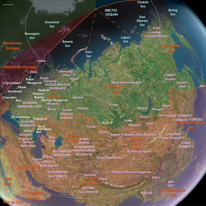
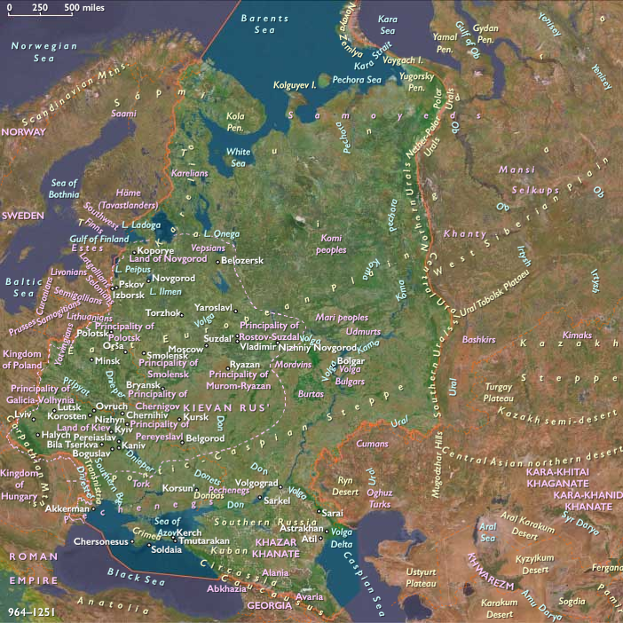
In the Russian northeast, East Slavs colonize …
Years: 1108 - 1251
In the Russian northeast, East Slavs colonize the territory that will eventually become Muscovy by intermingling with the Finno-Ugric tribes already occupying the area.
The city of Rostov is the oldest center of the northeast, but it is supplanted first by Suzdal' and then by the city of Vladimir.
By the twelfth century, the combined principality of Vladimir-Suzdal' has become a major power in Kievan Rus.
Locations
Groups
- Slavs, East
- Rus' people
- Novgorod, Principality of
- Rurik dynasty
- Kievan Rus', or Kiev, Great Principality of
- Hanseatic league (informally organized)
- Christians, Eastern Orthodox
- Novgorod Republic
- Vladimir-Suzdal, Great Principality of
Commodoties
Subjects
Regions
Subregions
Related Events
Filter results
Showing 10 events out of 49873 total
Mu'min had proclaimed an Almohad caliphate at Córdoba, giving the sultan supreme religious as well as political authority within his domains, but theology had gradually given way to dynastic politics as the motivating force behind the movement.
The Almohads had succeeded in unifying the Maghreb but, as its empire grew and the Almohad power base shifted to Spain, the dynasty has become more remote from the Berber tribes that had launched it.
By 1270 the Almohads in Morocco have succumbed to tribal warfare and in Spain to the steady advance of the Kingdom of Castile.
At the eastern end of the Almohad empire, the sultan leaves an autonomous viceroy whose office becomes hereditary in the line of Muhammad ibn Abu Hafs (reigned 1207-21), a descendant of one of Ibn Tumart's companions.
With the demise of the Almohad dynasty in Morocco, the Hafsids adopt the titles of caliph and sultan and consider themselves the Almohads' legitimate successors, keeping alive the memory of Ibn Tumart and the ideal of Maghrebi unity from their capital in Tunis.
The eleventh and twelfth centuries witness the rise in Morocco of two rival Berber tribal dynasties—the Almoravids and the Almohads, both founded by religious reformers—that dominate the Maghreb and Muslim Spain for more than two hundred years.
The founder of the Almohad (literally, "one who proclaims" the oneness of God) movement is a member of the Sunni ulama, Ibn Tumart (d. 1130), who preaches a doctrine of moral regeneration through reaffirmation of monotheism.
As judge and political leader as well as spiritual director, Ibn Tumart gives the Almohads a hierarchical and theocratic centralized government, respecting but transcending the old tribal structure.
His successor, the sultan Abdal Mu'min (reigned 1130-63), subdues Morocco, extends the Muslim frontier in Spain, and by 1160 has swept eastward across the Maghreb and forced the withdrawal of the Normans from their strongholds in Ifriqiya and Tripolitania, which are added to the Almohad empire.
The Origins of the Reconquista and the Expansion of Christian Rule
Resistance to the Muslim invasion of the Iberian Peninsula in the 8th century was initially limited to small groups of Visigothic warriors who had taken refuge in the mountains of Asturias, part of the former Suebic Kingdom. This region was one of the least Romanized and least Christianized parts of Spain, making it a natural stronghold for resistance.
Pelayo and the Birth of the Reconquista
According to tradition, Pelayo (718–737), King of Oviedo, first rallied the local Asturians to defend themselves against Muslim incursions. His resistance eventually turned offensive, marking the beginning of the seven-hundred-year Reconquista, which would later become the defining theme of medieval Spanish history.
What began as a struggle for survival in Asturias would evolve into a religious crusade to expel the Muslims from Spain and ultimately transform into an imperial mission to reconstruct a united Christian monarchy.
The Expansion of the Kingdom of León
Pelayo’s successors, later known as the Kings of León, extended Christian control southward from Asturias, gradually:
- Capturing territory from the Muslims,
- Depopulating and fortifying borderlands as defensive measures, and
- Resettling these reclaimed lands, reinforcing their control over the expanding frontier.
As Christian forces advanced, the political center of the kingdom shifted southward, following the military frontier, solidifying the role of León as the new heart of Christian resistance and expansion in Iberia.
West Antarctica (1108 – 1251 CE): Polar Plateaus, Ice Ranges, and Unpeopled Frontiers
Geographic and Environmental Context
West Antarctica includes the South Shetland Islands, the Antarctic Peninsula, and the continental block extending to the Polar Plateau.
It encompasses:
-
Mountain systems: the Central Transantarctic Mountains, Queen Maud, Whitmore, and Thiel Mountains, the Heritage and Executive Committee Ranges, and the Ellsworth Highlands.
-
Plateaus: Rockefeller, Hollick-Kenyon, and Joerg Plateaus.
-
Marie Byrd Land, fringed by the Ross and Amundsen Sea coasts.
-
Ice shelves: Ronne–Filchner, western Ross, and coastal shelves fringing Marie Byrd Land.
-
The region remained uninhabited by humans, dominated by glaciers, nunataks, and seasonal polynyas.
Climate and Environmental Shifts
-
The Medieval Warm Period (c. 950–1250) brought only marginal changes in this high-latitude environment.
-
Antarctic interior temperatures remained among the coldest on Earth.
-
Sea ice extent may have contracted slightly during summer months, allowing seasonal productivity in polynyas.
-
Katabatic winds swept down from the Polar Plateau, reinforcing ice flow into surrounding shelves.
Societies and Political Developments
-
No human settlement or contact.
-
The region lay entirely outside the voyaging or geographic knowledge of medieval peoples in Europe, Africa, or Polynesia.
Economy and Trade
-
No human economy.
-
Ecological productivity centered on:
-
Krill swarms forming the keystone species.
-
Penguin colonies (Adélie and chinstrap on the Peninsula; emperor penguins on the ice edge).
-
Seals (crabeater, leopard, and Weddell) breeding on sea ice.
-
Whales feeding in the Ross and Amundsen Seas during austral summers.
-
Subsistence and Technology
-
Not applicable to humans.
-
Animal adaptations:
-
Penguins nested communally on ice-free coasts.
-
Seals fasted during breeding seasons.
-
Whales timed migrations to coincide with krill blooms.
-
Lichens and mosses persisted in ice-free nunatak niches.
-
Movement and Interaction Corridors
-
Glacial systems: vast ice streams flowed from the Polar Plateau into the Ross and Ronne–Filchner shelves.
-
Marine migrations: whales and seals circulated through Ross, Weddell, and Amundsen Seas.
-
Bird flyways: seabirds ranged between subantarctic islands (South Shetlands, South Georgia) and Antarctic rookeries.
Belief and Symbolism
-
No direct human cosmologies tied to this land, though distant cultures (Byzantine, Islamic, Polynesian, Andean) carried myths of southern continents.
Adaptation and Resilience
-
Ecosystem resilience hinged on krill and seasonal polynyas.
-
Penguin and seal colonies thrived in undisturbed conditions.
-
Vegetation of lichens and mosses clung to nunataks, surviving in microclimates.
Long-Term Significance
By 1251, West Antarctica remained a pristine ecological reserve:
-
Marine and avian life flourished around seasonal polynyas and nutrient upwellings.
-
Its glacial interior and plateaus remained untouched by human presence or knowledge.
-
The region stood as one of the last great unpeopled frontiers of Earth, awaiting discovery many centuries later.
Northeastern Eurasia (1108 – 1251 CE): Forest Empires and Steppe Frontiers
Between 1108 and 1251 CE, Northeastern Eurasia was transformed from a mosaic of forest kingdoms and steppe confederations into the frontier of the Mongol world.
From the Amur River and Hokkaido to the Volga and Urals, new powers rose amid ecological wealth and continental expansion.
The Jurchen forged an empire in the east; Turkic and Kipchak nomads ruled the western steppe; and the fragmented Rus’ principalities contended with both Christian and shamanic frontiers before succumbing to Mongol conquest.
This was an age of mobility, resilience, and convergence—when rivers, forests, and grasslands became conduits of empire.
Geographic and Environmental Context
Northeastern Eurasia stretched from the Pacific coasts of the Sea of Okhotsk and the Bering Sea across the Amur basin, Siberian taiga, and steppe corridors to the Volga–Don–Dnieper plains of Eastern Europe.
It encompassed four great ecological zones:
-
The Amur basin and Manchurian forests of the Jurchen and Tungusic peoples;
-
The Siberian taiga and river networks of Ob, Yenisei, and Lena;
-
The Kipchak and Cuman steppe, bridging the Urals and Black Sea;
-
The Slavic forest-steppe, from Novgorod to Kiev and Vladimir-Suzdal.
These regions were bound together by rivers—the Amur, Volga, Ob, and Dnieper—forming a transcontinental lattice of trade and migration.
Climate and Environmental Shifts
During the Medieval Warm Period, milder temperatures lengthened growing seasons in the Amur basin and forest-steppe, supporting millet and rye cultivation.
Steppe pastures flourished, expanding herding economies and nomadic confederations.
The taiga and tundra, though cold, yielded rich furs, fish, and reindeer pastures.
This climatic stability fueled demographic growth and cross-ecological exchange—from Amur agriculture to Volga fur trade—creating the material base for imperial expansion.
Societies and Political Developments
The Jurchen and the Jin Empire (1115–1234):
The Jurchens, a Tungusic people from the Amur basin, overthrew the Khitan Liao and founded the Jin dynasty in northern China.
They blended sedentary agriculture, hunting, and cavalry warfare, ruling from Zhongdu (Beijing) while maintaining their Manchurian heartland.
Their military power rested on armored cavalry and composite bows; their culture fused shamanism with Chinese statecraft.
By 1234, the Mongols had destroyed the Jin, incorporating Manchuria into their empire.
The Steppe and the Kipchak Confederation:
To the west, Turkic Kipchaks (Polovtsy) dominated the steppe from the Irtysh to the Dnieper, controlling caravan routes and serving as mercenaries and horse traders.
They linked the Siberian forests to the Black Sea markets, mediating between Islamic Central Asia and Christian Rus’.
Their confederation began to fracture under Mongol advance after 1220, leading to the rise of the Golden Horde in the mid-13th century.
The Forest Peoples of Siberia:
Ob-Ugric and Samoyedic societies—the Khanty, Mansi, Nenets, and Selkup—maintained hunting, fishing, and reindeer herding across the taiga.
Clan structures and animist rituals governed resource use, while furs and slaves were exchanged southward for metal and salt.
These groups remained autonomous until Mongol and Russian expansion centuries later.
The Fragmented Rus’ Principalities:
After the decline of Kievan Rus’, regional powers emerged:
-
Novgorod, governed by merchant boyars, thrived on Baltic trade.
-
Vladimir-Suzdal rose in the northeast, laying the foundation for Muscovy.
-
Galicia-Volhynia controlled the western frontier near Poland and Hungary.
Southern Rus’ faced constant pressure from the Cumans, while Orthodox monasteries preserved literacy and faith.
From 1223 (Battle of the Kalka River) to 1240 (Sack of Kiev), Mongol armies under Batu Khan subjugated Rus’, establishing tribute rule through the Golden Horde.
The Mongolic Advance:
By the early 13th century, Temüjin (Chinggis Khan) unified Mongol tribes, then absorbed Turkic and Tungusic neighbors.
His campaigns swept westward across Siberia and into Eastern Europe, forging a continental network of conquest, trade, and communication that transformed the region’s political geography forever.
Economy and Trade
Northeastern Eurasia’s wealth lay in ecological diversity:
-
Amur Basin: millet, soybeans, hemp, and fish fed the Jurchen core.
-
Steppe: horses, sheep, and camels supported nomadic confederations.
-
Forest and tundra: furs, wax, and reindeer products entered long-distance trade.
-
Rus’ cities: exported wax, honey, furs, and slaves via the Volga and Dnieper to Byzantium and the Baltic.
Major trade arteries:
-
Amur–Ussuri river routes linking Manchuria to the Pacific.
-
Ob–Yenisei–Irtysh network joining Siberian hunters to steppe nomads.
-
Volga–Caspian corridor channeling Rus’ and Kipchak trade into the Islamic world.
-
Dnieper–Black Sea route connecting Kiev to Byzantium.
By the mid-13th century, the Mongols had integrated these disparate circuits into one imperial economy stretching from China to the Danube.
Subsistence and Technology
-
Jurchen agriculture used slash-and-burn and permanent fields; their cavalry revolutionized warfare in Manchuria.
-
Steppe nomads perfected mounted archery, using yurts and herds as mobile assets.
-
Forest peoples employed birchbark canoes, skis, and sleds for seasonal hunting and transport.
-
Rus’ settlements used watermills and iron tools; kremlins (fortified towns) arose along trade routes.
-
Ainu, Chukchi, and Koryak combined maritime hunting and reindeer herding with spiritual reciprocity toward nature.
Together these technologies of mobility and adaptation allowed human settlement across one of the world’s most extreme environments.
Belief and Symbolism
Faith and cosmology mirrored ecology and power:
-
Shamanism united forest and steppe peoples through reverence for sky, animal, and ancestral spirits.
-
Tengriism sanctified the nomadic order of the Mongols and Kipchaks.
-
Orthodox Christianity unified the Rus’ under Byzantine cultural influence.
-
Buddhist and Daoist ideas filtered northward through the Jin and Tangut realms.
-
Among the Ainu, Chukchi, and Koryak, rituals of reciprocity with animal spirits preserved environmental equilibrium.
Religion became the principal vector of cultural exchange—from Orthodox missions in Karelia to Buddhist texts carried by caravans.
Movement and Interaction Corridors
-
The Amur River system: artery of agriculture, trade, and Jurchen expansion.
-
The Ob and Yenisei rivers: linked fur frontiers to Central Asia and Volga markets.
-
The Steppe Road: nomadic highway connecting Mongolia, Kipchak plains, and Eastern Europe.
-
The Dnieper and Volga routes: carried merchants, warriors, and monks between Rus’ and Byzantium.
-
The Arctic seaways and Bering Strait: sustained cultural continuity between Chukchi and Alaskan Inuit.
These corridors transformed the Eurasian north from isolated ecologies into a dynamic continental web.
Adaptation and Resilience
-
Ecological flexibility—farming, herding, hunting—ensured survival in diverse climates.
-
Political pluralism—city republics, nomadic clans, tribute networks—absorbed shocks from invasion and climate.
-
Cultural continuity—shamanism and Orthodoxy alike—provided spiritual stability amid conquest.
-
Mongol integration replaced fragmentation with imperial networks that protected trade and communication.
Resilience in this frontier lay in diversity: a patchwork of cultures thriving within the rhythms of steppe and forest.
Long-Term Significance
By 1251 CE, Northeastern Eurasia had been transformed:
-
The Jurchen Jin dynasty had risen and fallen to the Mongols, integrating Manchuria into a trans-Eurasian order.
-
The Kipchak steppe became the nucleus of the Golden Horde.
-
The Rus’ principalities endured under Mongol tribute, their centers shifting north toward Moscow.
-
The forest and tundra peoples maintained autonomy at the edges of empire.
-
Across the Pacific, the Ainu, Chukchi, and Koryak preserved ancient lifeways amid new trade links.
In this age, conquest and ecology intertwined: the Mongols unified the steppe, the forests fed global commerce, and the great rivers carried Northeastern Eurasia into the heart of the medieval world-system.
Northeast Asia (1108 – 1251 CE): Jurchen Ascendancy, Mongolic Expansion, and the Transformation of the Steppe
Geographic and Environmental Context
Northeast Asia includes the easternmost areas of Siberia (east of 130°E), the extreme northeastern Heilongjiang region of China, the Chukchi Peninsula, the Kamchatka Peninsula, the Russian Far East, the Amur River basin, and Hokkaido.
-
This was a land of vast forests, tundra, and river valleys, bounded by the Pacific coastlines of the Sea of Okhotsk and the Bering Sea.
-
The Amur River basin provided fertile lowlands for agriculture and fishing.
-
The Kamchatka and Chukchi peninsulas remained sparsely inhabited, sustaining hunting, fishing, and reindeer herding.
-
Hokkaido was home to Ainu communities, distinct in culture from the Japanese heartlands to the south.
Climate and Environmental Shifts
-
The Medieval Warm Period moderated winters slightly, improving agricultural conditions in the Amur basin and supporting population growth among farming societies.
-
Despite this, harsh winters continued in Siberia and the Kamchatka–Chukchi north, where subsistence remained primarily hunting and fishing.
-
Stable marine ecosystems supported rich fisheries along the Pacific coast.
Societies and Political Developments
-
Jurchen Empire: In 1115, the Jurchens (ancestors of the Manchus) established the Jin dynasty in northern China after overthrowing the Khitan Liao. Their homeland lay in the forests and river valleys of Northeast Asia, where they combined hunting, fishing, and agriculture.
-
Mongolic Expansion: Mongolic-speaking groups began pressing eastward, disrupting steppe and forest peoples, foreshadowing the Mongol conquests of the 13th century.
-
Tungusic peoples remained widespread across the Amur and Ussuri basins, maintaining semi-sedentary lifeways and tribute relations with more powerful neighbors.
-
Ainu of Hokkaido maintained autonomous chiefdoms, engaged in trade with northern Honshu, and relied on hunting, fishing, and horticulture.
-
Chukchi and Koryak in the far northeast preserved mobile, kinship-based societies oriented to reindeer herding, fishing, and sea mammal hunting.
Economy and Trade
-
Amur Basin agriculture centered on millet, soybeans, and hemp, supplemented by fishing and hunting.
-
The Jurchen economy integrated tribute, farming, and control over northern Chinese trade networks.
-
Ainu traded furs, marine products, and hawk feathers with Japan, receiving iron tools, rice, and cloth.
-
Maritime and riverine exchange circulated furs, ginseng, honey, salt, and metals across the Amur, Ussuri, and Pacific coast.
-
The steppe corridor enabled the movement of horses and livestock, linking the region to broader Inner Asian exchange.
Subsistence and Technology
-
Jurchen farming combined slash-and-burn techniques with permanent fields in the Amur basin.
-
Composite bows, iron weapons, and armored cavalry made the Jurchens formidable military opponents.
-
Ainu technologies included pit dwellings, lacquered woodcraft, and fishing tools adapted to Hokkaido’s environment.
-
Chukchi and Koryak used skin boats (umiaks), dog sleds, and reindeer herding to survive in tundra ecologies.
-
Pottery, textiles, and wooden ritual implements reflected both practicality and cultural identity.
Movement and Interaction Corridors
-
The Amur River functioned as a major artery of movement, uniting farming and fishing settlements.
-
The Sea of Okhotsk connected maritime communities by canoe and larger boats.
-
Overland steppe routes tied Jurchens and Mongolic groups to northern China and Central Asia.
-
Hokkaido maintained steady interaction with Honshu through trade and occasional conflict.
-
The Bering Strait linked Chukchi to Alaskan Inuit, sustaining trans-Arctic cultural continuities.
Belief and Symbolism
-
Jurchen religion combined shamanistic traditions with Buddhist and Daoist elements adopted from China.
-
Ainu spirituality venerated animal spirits, especially the bear (kamuy), with rituals emphasizing reciprocity between humans and nature.
-
Chukchi and Koryak cosmologies centered on animist traditions, with shamans mediating with spirits of sea and tundra.
-
Rituals tied to hunting, fishing, and herding reinforced ecological balance and communal identity.
Adaptation and Resilience
-
Agricultural intensification and tribute networks sustained the Jurchens, enabling the rise of the Jin dynasty.
-
Mobile pastoralism and maritime hunting supported Chukchi, Koryak, and Ainu resilience in harsh climates.
-
Trade in furs, iron, and marine resources linked scattered societies into a resilient web of exchange.
-
Flexibility in combining farming, hunting, and fishing allowed communities to adapt to environmental variability.
Long-Term Significance
By 1251 CE, Northeast Asia had been reshaped by the Jurchen rise to power, the expansion of Mongolic peoples, and the enduring resilience of Ainu, Chukchi, and Koryak lifeways. The region’s integration into larger East Asian and Inner Asian systems foreshadowed the transformative impact of the Mongol Empire, while maintaining its deep-rooted traditions of shamanism, maritime exchange, and ecological adaptation.
Northern North America (1108 – 1251 CE): Mound Empires, Maritime Chiefdoms, and Arctic Frontiers
Between 1108 and 1251 CE, the northern half of North America witnessed extraordinary cultural florescence.
Along the Mississippi and Gulf coasts, mound-building chiefdoms reached their urban zenith.
Across the Pacific Northwest, cedar-plank towns and potlatch chiefdoms thrived on salmon surpluses.
In the northeast, the great city of Cahokia towered over the interior plains while Iroquoian and Algonquian farmers expanded across the forests.
Farther north and west, Norse settlers in Greenland and Inuit hunters in the Arctic maintained one of the world’s oldest transpolar connections.
The entire continent—linked by rivers, trade routes, and seaways—became a web of powerful regional civilizations, each adapting to its unique environment while exchanging goods, symbols, and ideas.
Geographic and Environmental Context
Northern North America encompassed the Pacific rainforests, the Great Plains and Mississippi basin, the Appalachian and Laurentian uplands, and the Arctic–subarctic tundra.
-
The Pacific coast was a land of fjords, cedar forests, and salmon-rich rivers.
-
The Great Lakes and Mississippi plains formed an agricultural heartland sustained by maize cultivation.
-
The Gulf and Southwest zones supported irrigated farming and trade networks.
-
The Arctic north and Greenland lay within zones of fishing, hunting, and ice navigation.
This ecological variety produced some of the richest subsistence systems in the pre-Columbian world, from intensive agriculture to marine economies.
Climate and Environmental Shifts
The Medieval Warm Period (c. 950–1250) brought longer growing seasons, higher yields, and stable fisheries.
-
Cahokia’s floodplain produced maize surpluses supporting large urban populations.
-
Northwest Coast rivers experienced peak salmon runs, anchoring food wealth and social stratification.
-
The Southwest and Great Basin faced early droughts after 1200, pressuring Puebloan migrations.
-
Greenland’s Norse colonies prospered marginally, grazing livestock and exporting walrus ivory.
Milder conditions stimulated demographic growth across nearly every ecological zone.
Societies and Political Developments
Pacific Northwest Chiefdoms:
Tlingit, Haida, Tsimshian, Kwakwaka’wakw, and Coast Salish societies developed ranked, hereditary systems rooted in salmon control and trade monopolies.
Villages of plank houses lined fjords; cedar canoes carried goods and warriors along the Inside Passage.
Potlatch ceremonies and monumental totems dramatized wealth and ancestry.
In Alaska, Yup’ik and Inupiat communities combined maritime hunting and reindeer herding, sustaining life along the tundra coasts.
Interior and Plateau Peoples:
Nlaka’pamux, Ktunaxa, and Dene (Athabaskan) groups inhabited interior valleys, mixing foraging and horticulture.
Southward Dene migrations foreshadowed the later rise of Apache and Navajo peoples.
The Mississippian Mound World:
At its height (~1200 CE), Cahokia near modern St. Louis supported over 20,000 inhabitants, dominated by Monk’s Mound and vast plazas aligned to celestial cycles.
Its influence radiated through networks linking Etowah, Moundville, Spiro, and Natchez.
Elites commanded maize tribute, ritual authority, and long-distance trade in copper, shell, and stone.
Farther south, Gulf chiefdoms maintained continuity after Cahokia’s decline.
Puebloan and Western Cultures:
The Ancestral Puebloans (Mesa Verde, Chaco Canyon) reorganized into larger mesa-top and cliff settlements as drought stressed irrigation networks.
Hohokam farmers maintained extensive canal systems along the Salt and Gila rivers, cultivating cotton and maize despite increasing salinity.
On the Pacific coast of California, Chumash and Tongva chiefdoms expanded canoe trade using shell-bead currencies that circulated for hundreds of miles.
Eastern Woodlands and Great Lakes:
In the northeast, Iroquoian and Algonquian societies flourished.
Iroquoian-speaking groups in Ontario and New York built longhouse villages and palisaded towns, experimenting with confederacies that would later coalesce into the Haudenosaunee League.
Algonquians along the coasts and rivers practiced mixed farming, fishing, and foraging, forming dynamic regional alliances.
Arctic and North Atlantic Frontiers:
Thule Inuit expanded eastward across the Canadian Arctic, mastering seal and whale hunting, sled technology, and snowhouse construction.
Across the sea, Norse Greenlanders built churches, exported ivory, and traded intermittently with Europe via Iceland and Norway.
The Bering Strait maintained trans-Arctic contact between Chukchi and Alaskan Inuit peoples—one of humanity’s oldest enduring links.
Economy and Trade
Agriculture and Food Systems:
-
Mississippi–Ohio valleys: intensive maize agriculture and fish weirs supported dense populations.
-
Great Lakes and Northeast: maize-bean-squash “Three Sisters” cultivation spread.
-
Pacific Northwest: salmon, halibut, and shellfish formed the subsistence core.
-
California: acorn and seed processing underpinned regional stability.
-
Arctic: seal, walrus, and whale provided meat, oil, and tools.
Trade Networks:
-
Cahokian exchange moved copper from the Great Lakes, shells from the Gulf, and obsidian from the Rockies.
-
Northwest Coast trade linked coastal and interior peoples through copper, hides, and slaves.
-
California–Great Basin routes exchanged obsidian, salt, and shell beads.
-
Arctic exchanges carried ivory, furs, and metal objects between Inuit, Norse, and Siberian groups.
Continental trade created overlapping economic spheres connected by rivers, trails, and maritime corridors.
Belief and Symbolism
-
Mississippian ceremonialism: cosmologies of upper and lower worlds, fertility, and warfare expressed through mound alignments and copper iconography.
-
Northwest Coast mythology: clan totems, animal transformations, and ancestral spirits materialized in carvings and masks.
-
Puebloan religion: kiva rituals and katsina cults linked agriculture to celestial order.
-
Iroquoian cosmology: stories of Sky Woman and the Earth-Diver mirrored social harmony within the longhouse.
-
Inuit and Yup’ik spirituality: maintained reciprocity with sea and ice spirits through hunting rites.
-
Norse Christianity: churches and burials in Greenland reflected both European piety and Arctic endurance.
In every region, spiritual life united ecology, kinship, and cosmic order.
Subsistence and Technology
-
Cedar woodworking supported monumental architecture and seafaring in the Northwest.
-
Fish traps, weirs, and smokehouses maximized salmon preservation.
-
Mound construction required organized labor and astronomical precision.
-
Hohokam canal engineering extended irrigation over miles of desert terrain.
-
Shell-bead currency standardized exchange in California and along the Pacific.
-
Kayaks, umiaks, and sleds enabled Arctic mobility; iron and ivory tools diffused through Norse-Inuit contact.
Technological ingenuity adapted each environment into a landscape of abundance.
Movement and Interaction Corridors
-
Inside Passage: Alaska ⇄ British Columbia ⇄ Puget Sound, uniting maritime chiefdoms.
-
Mississippi–Ohio system: Cahokia ⇄ Etowah ⇄ Gulf coast, artery of mound culture.
-
Rocky Mountain trails: linked Puebloan, Plains, and Mississippian traders.
-
Great Lakes–St. Lawrence routes: connected Iroquoian farmers to Atlantic trade.
-
Gulf Stream crossings: carried Norse ships from Greenland to Iceland, and Inuit hunters across Baffin Bay.
These corridors wove a continental web of exchange and symbolic contact from the Arctic to the Gulf.
Adaptation and Resilience
-
Agricultural diversification and surplus storage sustained Mississippian and Iroquoian societies.
-
Salmon abundance and maritime trade stabilized Northwest chiefdoms.
-
Irrigation, terrace farming, and ritual cooperation buffered Pueblo communities against drought.
-
Mobility and ecological knowledge allowed Inuit, Yup’ik, and Dene survival under Arctic conditions.
-
Ritual redistribution (potlatch, mound feasts) maintained social cohesion during scarcity.
Resilience lay in flexibility—combining surplus economies with spiritual systems that honored ecological balance.
Long-Term Significance
By 1251 CE, Northern North America was a mosaic of civilizations, each reflecting mastery of its environment:
-
Cahokia stood as the continent’s largest pre-Columbian city, symbol of agrarian urbanism.
-
Northwest Coast chiefdoms flourished in wealth, art, and ceremonial complexity.
-
Pueblo and Hohokam towns persisted as centers of irrigation and ritual innovation.
-
Iroquoian and Algonquian farmers expanded their forest domains.
-
Inuit hunters and Norse settlers maintained the northernmost economies on Earth.
Together they composed an intricate continental system—distinct yet interconnected—whose cultural and ecological foundations would endure long after 1251, even as the medieval world beyond the seas moved toward global convergence.
Northwestern North America (1108 – 1251 CE): Coastal Chiefdoms, Athabaskan Migrations, and Maritime Worlds
Geographic and Environmental Context
Northwestern North America includes western Canada (from British Columbia to the Yukon), Alaska and Washington in the United States, northern Idaho, and the northwestern portions of Montana, Oregon, and California.
-
The Pacific Northwest coast featured fjords, islands, and temperate rainforests, rich in salmon and cedar.
-
Alaska contained tundra, boreal forest, and marine ecosystems tied to the Bering Sea and Gulf of Alaska.
-
The interior plateaus of British Columbia and the Columbia River basin sustained riverine and upland communities.
-
Ecological diversity fostered complex fishing economies, maritime cultures, and interior foraging-horticultural blends.
Climate and Environmental Shifts
-
The Medieval Warm Period improved productivity in northern latitudes, increasing salmon runs and supporting larger populations along rivers.
-
In the subarctic, milder winters facilitated caribou hunting and extended habitation zones northward.
-
Coastal abundance buffered populations against climatic fluctuation, though occasional shifts in salmon cycles shaped subsistence strategies.
Societies and Political Developments
-
Northwest Coast chiefdoms flourished: the Tlingit, Haida, Tsimshian, Kwakwaka’wakw, and Coast Salish developed ranked societies, with nobles, commoners, and slaves.
-
Wealth and authority centered on control of salmon streams, cedar resources, and trade routes, expressed in potlatch ceremonies.
-
In Alaska, Yup’ik and Inupiat communities combined maritime hunting (seals, whales) with fishing and reindeer herding in tundra zones.
-
Athabaskan (Dene) migrations pushed southward into the interior Northwest, foreshadowing later Navajo and Apache dispersals farther south.
-
Interior groups such as the Nlaka’pamux and Ktunaxa maintained flexible forager-horticultural systems, interacting with both Plains and coastal societies.
Economy and Trade
-
Salmon fishing was the economic foundation of the Pacific Northwest, supported by weirs, traps, and seasonal migrations.
-
Cedar wood provided canoes, plank houses, and monumental carvings.
-
Long-distance trade connected coastal and interior peoples: shells, copper, obsidian, and hides circulated widely.
-
The Kuskokwim and Yukon river systems in Alaska linked subarctic hunters to coastal economies.
-
Slavery was practiced, with captives exchanged through trade and warfare.
Subsistence and Technology
-
Weirs, fish traps, and smokehouses preserved salmon surpluses.
-
Large plank houses sheltered extended families and symbolized lineage prestige.
-
Ocean-going canoes, carved from cedar logs, enabled trade, raiding, and whaling.
-
Alaska’s maritime hunters used kayaks and umiaks, harpoons, and toggling heads for sea mammals.
-
Potlatch feasts redistributed goods, reinforcing social hierarchies and reciprocal obligations.
Movement and Interaction Corridors
-
The Inside Passage along British Columbia and Alaska served as a major corridor for canoe trade.
-
Columbia River networks tied interior Plateau groups into coastal exchanges.
-
Overland routes across mountain passes carried obsidian, copper, and hides into coastal markets.
-
The Bering Strait linked Alaskan Inuit with Chukchi and Siberian communities, maintaining a trans-Arctic cultural sphere.
Belief and Symbolism
-
Northwest Coast spirituality emphasized clan totems, ancestral spirits, and animal transformations, expressed in monumental totem poles and masks.
-
Shamans mediated healing and communication with spirit beings.
-
In Alaska, ritual life honored sea spirits and whale hunters, with ceremonies ensuring balance between humans and animals.
-
Potlatch ceremonies fused political authority with spiritual obligation, legitimizing noble lineages.
Adaptation and Resilience
-
Abundant salmon and cedar resources provided stable surpluses for coastal societies.
-
Flexibility in subsistence—mixing fishing, hunting, and horticulture—ensured resilience in interior groups.
-
Maritime adaptations in Alaska buffered against Arctic harshness.
-
Potlatch redistribution reinforced community stability during times of scarcity.
Long-Term Significance
By 1251 CE, Northwestern North America was a center of complex maritime chiefdoms and transcontinental exchange. Pacific Northwest societies developed some of the most stratified and ceremonial cultures in the Americas, while Athabaskan migrations reshaped the interior. With their salmon-based economies, cedar technologies, and potlatch traditions, these communities forged a durable cultural system that would endure for centuries, even as outside pressures transformed the wider world.
Years: 1108 - 1251
Locations
Groups
- Slavs, East
- Rus' people
- Novgorod, Principality of
- Rurik dynasty
- Kievan Rus', or Kiev, Great Principality of
- Hanseatic league (informally organized)
- Christians, Eastern Orthodox
- Novgorod Republic
- Vladimir-Suzdal, Great Principality of
Commodoties
Subjects
Regions
Subregions