Central Europe (28,577 – 7,822 BCE): Late …
Years: 28577BCE - 7822BCE
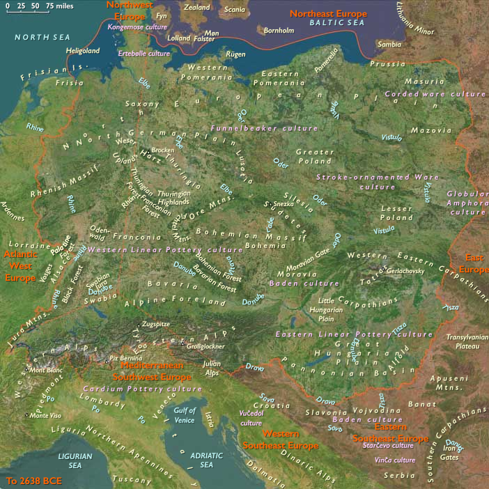
Central Europe (28,577 – 7,822 BCE): Late Pleistocene–Early Holocene — Loess Rivers, Lake Basins, and the Forest Turn
Geographic & Environmental Context
As the Last Glacial Maximum waned, Central Europe unfolded as a triptych of recovering landscapes:
-
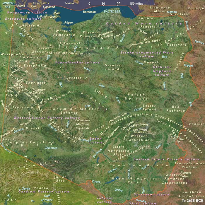
East Central Europe — the Upper Danube–Vienna Basin, Moravian Gate, Bohemian Basin, and the Oder–Vistula–Elbe plains, rimmed by the Carpathian Basin and Sudetes/Tatra forelands, where retreating ice left loess mantles, broad river terraces, and proglacial lakes (southern Poland–Moravia–Slovakia).
-
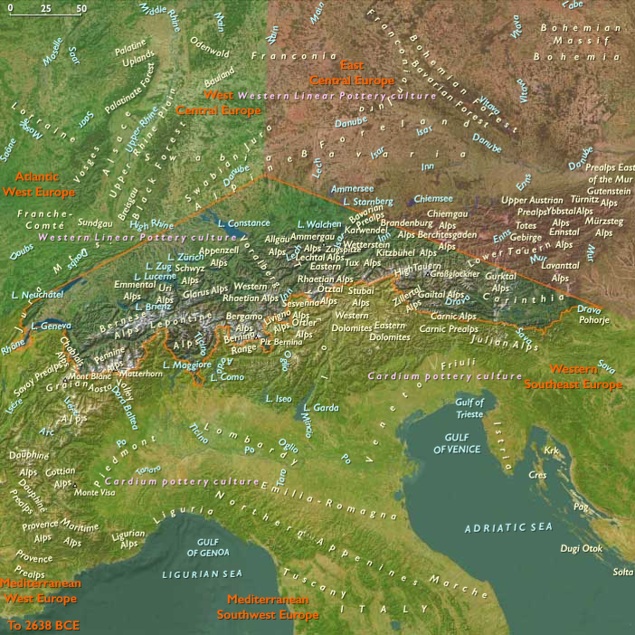
South Central Europe — the Alpine forelands and Swiss Plateau (Aare–Reuss–Rhône), Inn–Adige (Etsch) with the Brenner/Reschen chain, and the Great St. Bernard–Valais–Rhône and St. Gotthard trunks; a mosaic of lake basins, outwash fans, and reopened passes.
-
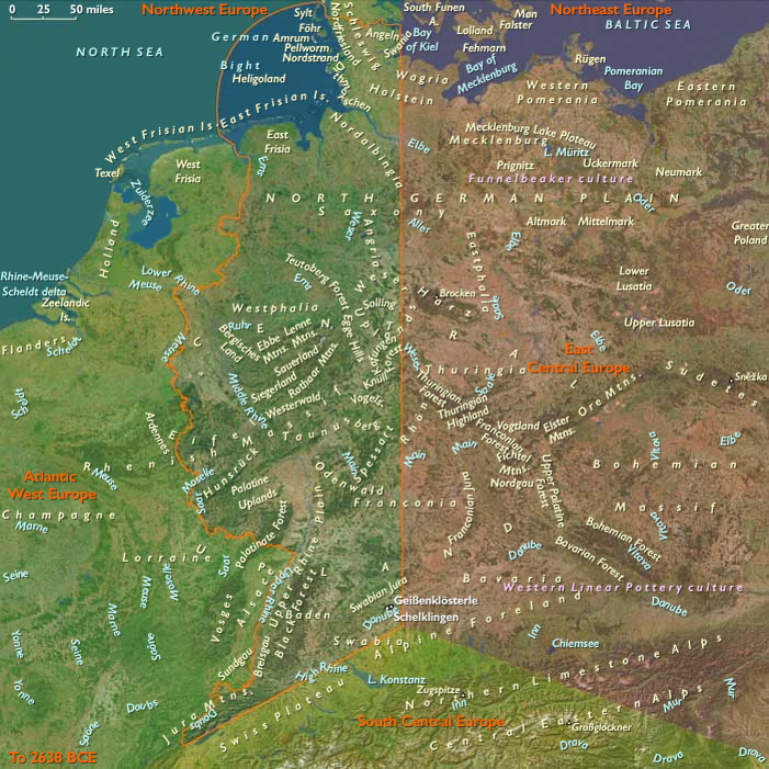
West Central Europe — the Rhine corridor and Jura uplands, extending to Germany west of 10°E; glacial valleys opening into temperate riverine belts threaded with caves and rock shelters.
Together these belts formed a north–south hydrological spine (Danube–Morava ↔ Alpine passes ↔ Rhine–Moselle–Seine; Vistula–Oder–Elbe to the Baltic) that funneled people, animals, and ideas through a terrain shifting from steppe to forest.
Climate & Environmental Shifts
-
Last Glacial Maximum (c. 26.5–19 ka): cold, dry, wind-scoured loess steppes; big rivers braided across wide floodplains; uplands carried periglacial belts.
-
Bølling–Allerød (c. 14.7–12.9 ka): rapid warming and higher precipitation; birch–pine–hazel expansion; lakes filled and stabilized; Alpine passes became seasonally traversable.
-
Younger Dryas (12.9–11.7 ka): brief cool-dry relapse; steppe patches returned on lowlands; lake levels dipped; foragers leaned harder on rivers and coasts.
-
Early Holocene (post-11.7 ka): sustained warmth/moisture; mixed broadleaf forests (oak–hazel–elm–lime)advanced; Rhine, Danube, and Alpine lake systems reached near-modern regimes.
The net effect was a continental forest turn, layered over inherited glacial topography.
Subsistence & Settlement
Broad-spectrum foraging anchored to water and edge habitats characterized all three subregions:
-
East Central Europe: seasonal lakeside and river-terrace camps in Poland, Moravia, and the Danube basin targeted elk, red deer, aurochs, river fish and waterfowl, with nuts/berries from re-established woods. Camp re-use and hearth relays signal proto-sedentary rhythms.
-
South Central Europe (Alpine forelands & Swiss Plateau): lake-edge hamlets and rock shelters proliferated; diets paired red deer/wild boar with pike, perch, waterfowl; nut-gathering in mixed forests. Early dugouts and shore platforms point to intensifying lacustrine lifeways.
-
West Central Europe (Rhine–Jura): late Glacial Magdalenian hunters (reindeer → red deer/boar) gave way to Early Mesolithic forest foragers, emphasizing fishing, small game, and nuts in riverine settings; small, mobile bands orbited stable cave/valley nodes.
Across the zone, settlement focused on lakes, levees, springs, and rock shelters, repeatedly revisited as resources cycled.
Technology & Material Culture
A versatile toolkit bridged ice-age legacies and Holocene needs:
-
Microlithic bladelets/geometrics (triangles, trapezes, backed blades) for composite arrows; bone/antler harpoons and gorges for intensified river/lake fishing.
-
Grinding stones (late), pecked cobbles, and anvils for nut and seed processing.
-
Early dugout canoes for lake/river mobility on the plateau; net sinkers and basketry implied by gear assemblages.
-
Magdalenian in the west: blades, burins, antler harpoons, and portable art; continuity into the Mesolithic with lighter microlithic sets.
-
Ornaments in amber, teeth, shell; ochre in burials and hearth contexts; engraved antler/stone and cave art in Jura/karst belts.
Movement & Interaction Corridors
Deglaciated valleys and reopened passes organized exchange:
-
Danube–Morava bound Balkans to the Central European loess plains; Vardar–Morava downstream connected to the Aegean.
-
Vistula–Oder–Elbe integrated Baltic forelands with interior uplands, moving flint, amber, shells, and stylistic traits.
-
St. Gotthard, Great St. Bernard, Brenner/Reschen linked the Swiss/Alpine lakes to the Po and upper Danube; Rheintal–Aare–Rhône axes stitched plateau with passes.
-
Rhine–Moselle–Seine carried Magdalenian/Mesolithic materials and ideas across western Europe.
These braided routes provided redundancy through climatic oscillations.
Cultural & Symbolic Expressions
Symbolic life remained rich and place-anchored:
-
Ochred burials with pendants and selected tools occur across plains and plateaus.
-
Ritualized hearths, structured activity zones, and lakeside deposits mark ceremonial reuse of favored camps.
-
Cave/rock-shelter art in Jura and other karsts persisted (stylized fauna, abstract signs); engraved antler/stone circulated as portable meaning.
-
In the west, lingering Magdalenian art and “hunting magic” motifs blended into Early Mesolithic aesthetics centered on rivers and forests.
Environmental Adaptation & Resilience
Households balanced mobility with place fidelity:
-
Edge-habitat focus (river/lake/forest margins) maximized diversity and buffered Younger Dryas stress.
-
Storage—dried fish/meat, roasted nuts—bridged lean seasons; flexible hunting/fishing mixes tracked herd shifts and water levels.
-
Aquatic technologies (dugouts, nets, harpoons) underwrote dependable protein as forests closed and big-game ranges shrank.
-
Pass-to-plain scheduling used Alpine windows efficiently, keeping exchange alive through seasonal closures.
Long-Term Significance
By 7,822 BCE, Central Europe had transitioned from glacial steppes to a temperate river-and-forest world:
-
East Central: loess valleys with recurrent terrace and lakeside camps;
-
South Central: lake-basin lifeways and nascent watercraft on the Swiss/Alpine forelands;
-
West Central: from Magdalenian hunters to forest Mesolithic fish-and-nut economies along the Rhine–Jura.
The shared operating code—water-edge settlement, diversified subsistence, storage, corridor mobility, and enduring ritual at hearth and burial—formed the deep substrate upon which Mesolithic florescence and, soon after, Neolithic farming trajectories up the Danube–Morava and across the Rhine–Main–Danube thresholds would be grafted.
Groups
Topics
Commodoties
Subjects
Regions
Subregions
Years: 28577BCE - 7822BCE
Groups
Topics
Commodoties
Subjects
Regions
Subregions