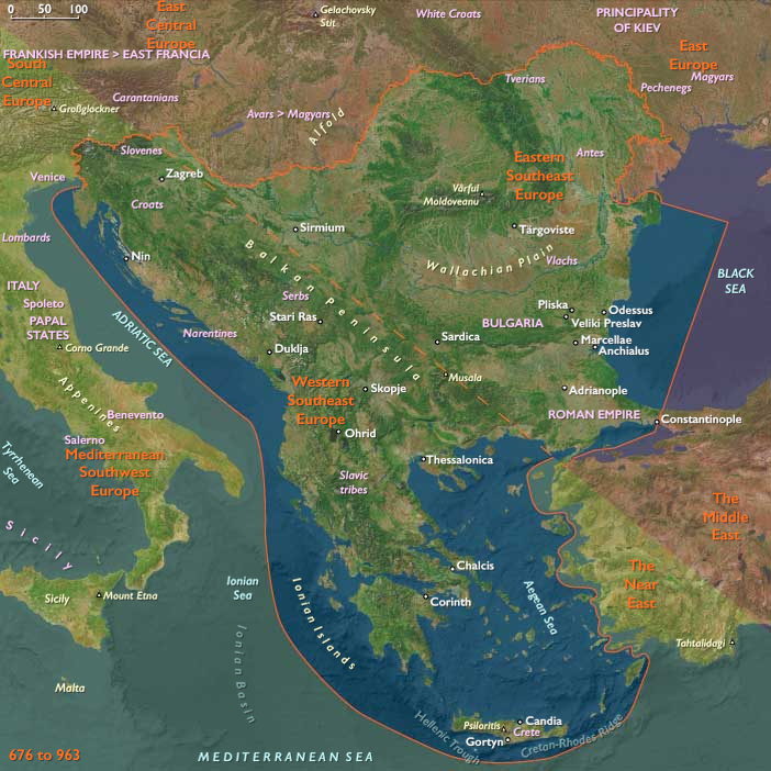
Athanasius, born in Trebizond and patronized by …
Years: 963 - 963
Athanasius, born in Trebizond and patronized by Michael Maleinos, had studied at Constantinople and become famous there as Abraham, a fervent preacher who holds great authority with Michael's nephew, Nikephorus Phokas.
Ill at ease with the lax morals of the monks living in the capital, Abraham had changed his name to Athanasius and joined the monks at Mount Kyminas in Bithynia.
He had relocated in 958 to Mount Athos.
He has helped defend the hermits, or sketes, here against the Saracens, and also started to incorporate the sketes already there into what will eventually become known as the Great Lavra, which Athanasius builds with the financial assistance of Nicephorus.
This monastery, dedicated in 963, is still in use today, and is often referred to by people of the area simply as "Lavra", or "The Monastery".
Locations
People
Groups
- Arab people
- Christianity, Chalcedonian
- Islam
- Saracens
- Crete, Emirate of
- Roman Empire, Eastern: Macedonian dynasty
Topics
Commodoties
Subjects
Regions
Subregions
Related Events
Filter results
Showing 10 events out of 52803 total
Information is lacking from Nigeria's "silent millennium" (first millennium CE) that follows the Nok ascendancy, apart from evidence of iron smelting on Dala Hill in Kano from about 600 to 700.
It is assumed, however, that trade linking the Niger region with North Africa plays a key role in the continuing development of the area.
Certainly by the beginning of the second millennium CE, there is an active trade along a north- south axis from North Africa through the Sahara to the forest, with the savanna people acting as intermediaries in exchanges that involve slaves, ivory, salt, glass beads, coral, cloth, weapons, brass rods, and other goods.
Hasdai ibn Shaprut continues to perform important services for Caliph al-Hakam II, in whose reign he will die.
Hasdai fosters the study of Jewish law and the Talmud (the rabbinic compendium of law, lore, and commentary), thereby making Spanish Jewry relatively independent of the Eastern Talmudic academies.
Hasdai's correspondence with a Jewish Khazar king, Joseph, written by Menahem ben Saruq, is of historic importance.
Allegedly, When he heard that in Central Asia there was a Jewish state with a Jewish ruler, he desired to enter into correspondence with this monarch; and when the report of the existence of the state of the Khazars was confirmed by two Jews, Mar Saul and Mar Joseph, who had come in the retinue of an embassy from the Croatian king to Córdoba, Hasdai entrusted to them a letter, written in good Hebrew addressed to the Jewish king, Joseph ben Aaron, in which he gave an account of his position in the Western state, described the geographical situation of Andalusia and its relation to foreign countries, and asked for detailed information in regard to the Khazars, their origin, their political and military organization, etc.
A man of extensive contacts and virtually unlimited resources, Hasdai had learned of the existence of the Khazars from Khorasani merchants.
His ignorance of the Khazar state is odd, and may even have been disingenuous, given Joseph's statements to the effect that there had been communications between the two communities in the past.
Nikephoros has employed brilliant strategy n the campaigns of 962–963 to conquer the cities of Cilicia and to advance into Syria, where had captured Aleppo, in collusion with his nephew, John Tzimiskes, but they had made no permanent conquests.
It is on these campaigns that he has earned the sobriquet, "The Pale Death of the Saracens".
Emperor Romanos II dies unexpectedly of uncertain cause on March 15, 963, at the age of twenty-six.
Both contemporary sources and later historians seem to either believe that the young Emperor had exhausted his health with the excesses of his sexual life and his heavy drinking, or suspect Empress Theophano, his wife, of poisoning him.
Theophano had already gained a reputation as an intelligent and ambitious woman.
She will later gain a reputation for ruthlessness in achieving her goals.
Romanos had already crowned as co-emperors his two sons Basil II and Constantine VIII.
At the time of Romanos' death, however, Basil is five years old and Constantine only three years old, so Theophano is named regent.
Theophano is not allowed to rule alone.
Joseph Bringas, the eunuch palace official who had become Romanos' chief councilor, maintains his position.
According to contemporary sources he intended to keep authority in his own hands.
He also tries to reduce the power of Nikephoros Phokas.
The victorious general had been accepted as the actual commander of the army and maintains his strong connections to the aristocracy.
Joseph is afraid that Nikephoros could claim the throne with the support of both the army and the aristocracy.
Joseph's intrigues during the following months will turn both Theophano and Nikephoros against him.
Nikephoros is very popular, but there is no indication that the general—whose physical appearance at fifty-one is reportedly not very agreeable and who seems destined under the influence of Athanasius the Athonite to embrace the monastic life—will end up seducing and being seduced by the young and beautiful empress.
If such a plan exists at this time (and there is reason to believe it does), it is probably the brainchild of the ambitious Theophano, who is unhappy with Bringas' government.
Unknown to Joseph, Nikephoros is urged to seize the throne by his nephew John Tzimiskes, and he enters into negotiations with Theophano.
With the help of Theophano and the patriarch, Nikephoros Phokas receives supreme command of the eastern forces.
The people of Constantinople, aroused by the eunuch minister Basil the chamberlain, revolt against Bringas, and the imperial army, through the intermediation of the Armenian general John Tzimisces, Nikephoros' nephew and faithful lieutenant, “obliges” the soldier to accept the crown at Caesarea on July 3, 963, and to march against Constantinople, where his partisans have overthrown his enemy Bringas.
Thanks to his popularity with the army, Nikephoros II Phokas is crowned emperor by the patriarch Polyeuctus at the side of Romanos's young sons in the Hagia Sophia on August 16, 963.
In spite of the opposition of the patriarch, the new emperor marries their mother, the regent Theophano, on September 30.
Tzimisces, descended from an aristocratic Armenian family and related through his mother to Nikephoros, had entered the imperial army and fought with Nikephoros against the Arabs in Cilicia and Syria.
His reward for having helped Nikephoros gain the throne is the supreme command of imperial forces in the East, though the emperor retains personal command of operations against the Arabs.
Early in his life, Nikephoros had married one Stephano, who had died before his rise to fame, and after her death he had taken an oath of chastity.
This will create problems later on.
We begin in the easternmost subregions and move westwardly around the globe, crossing the equator as many as six times to explore ever shorter time periods as we continue to circle the planet. The maps of the regions and subregions change to reflect the appropriate time period.
Narrow results by searching for a word or selecting from one or more of a dozen filters.
Northeast Eurasia (964 – 1107 CE): Liao Frontiers, Jurchen Leagues, and the Fur–Silver Networks of the Forests
Geographic and Environmental Context
Northeast Eurasia stretched from the Carpathian frontier of Kievan Rus’ and the Volga steppes through the West Siberian Plain, Amur–Heilongjiang basin, and Russian Far East to Hokkaidō and the Okhotsk coast.
This immense region linked the Eurasian forest and steppe worlds—taiga, tundra, and riverine plains—into a web of exchange reaching both the Byzantine–Islamic and East Asian empires.
Major river systems—Volga, Ob, Irtysh, Yenisei, Amur, and Dnieper—functioned as arteries of movement, while the Okhotsk Sea, Sakhalin–Hokkaidō corridor, and northern Pacific coasts sustained maritime hunting and limited trade.
Climate and Environmental Shifts
The Medieval Warm Period (c. 950–1250) slightly softened the subarctic climate.
-
Southern Siberia and the Amur basin saw longer growing seasons that permitted limited millet cultivation.
-
Forest-steppe margins expanded northward, improving grazing for Kyrgyz and Kipchak herds.
-
Salmon runs increased in the Amur and Okhotsk regions, while reduced ice along the Sea of Okhotsk opened new sea lanes.
These stable ecologies encouraged denser settlement in river valleys and intensified long-distance trade in furs, fish, and forest goods.
Societies and Political Developments
Kievan Rus’ and the Fall of Khazaria
In the southwest, Prince Sviatoslav of Kiev (r. 945–972) destroyed the Khazar Khaganate (964–969), ending centuries of steppe control over the Volga–Caspian gateway.
The victory transferred riverine hegemony to the Kievan Rus’, who dominated the Dnieper trade route to Byzantium and extended tributary claims northward to Novgorod and eastward toward the Volga Bulgars.
Vladimir I (r. 980–1015) Christianized Rus’ in 988, aligning it with Byzantine Orthodoxy; his son Yaroslav the Wise (r. 1019–1054) codified law and patronized cathedrals.
By the 11th century, Rus’ had become a federation of princely centers—Kiev, Novgorod, Smolensk, Chernigov—linked by rivers and fortified towns.
To the east, Volga Bulgars, Islamized in 922, prospered as intermediaries in the fur and silver trade, replacing Khazaria as the Islamic world’s northern supplier.
The Steppe and Taiga Frontiers
Beyond the settled Slavic–Finnic belt stretched the forest–steppe mosaics of Siberia.
The Yenisei Kyrgyz, heirs to the Uyghurs, maintained a khaganate in the Minusinsk Basin, collecting tribute from taiga hunters.
To their west, Kipchak confederations rose after the decline of the Kimeks, expanding along the Ishim–Irtysh corridor and absorbing Turkic groups.
By 1107 they dominated the western Siberian steppe, pressing Oghuz tribes westward toward Khwarazm and the Caspian, while coexisting with forest Ob-Ugric and Samoyedic hunters farther north.
The Forest and Riverine Peoples
Across the taiga, Ob-Ugric (Khanty, Mansi), Selkup, Ket, Nenets, and Evenki clans maintained kin-based communities centered on fishing, trapping, and reindeer herding.
Shamanic leadership coordinated seasonal migration and exchange.
To the east, Amuric-speaking Nivkh, Ulch, and Nanai (Hezhe) prospered on salmon harvests and seal hunts, sending tribute furs and falcons south to the Khitan Liao Empire (907–1125).
The Liao integrated the Amur tributaries into a regulated frontier system without annexation, trading iron and silk for pelts and ginseng.
The Rise of the Jurchen and Liao Frontiers
Among the Mohe descendants in the upper Amur, Jurchen tribal leagues formed by the 11th century, uniting millet farmers, hunters, and horsemen under chieftains who acknowledged, yet defied, Liao authority.
These confederations would later generate the Jin dynasty (1115–1234).
Further south, Song China traded indirectly through Liao markets, absorbing furs and ginseng from these northern intermediaries.
The Pacific Fringe and Hokkaidō
Along the Okhotsk coast, Koryak, Itelmen, and Chukchi sustained sea-mammal hunting and reindeer nomadism, bartering ivory and hides westward.
On Hokkaidō, the waning Okhotsk culture merged with the Satsumon tradition, producing a distinct Ainuethnogenesis—combining fishing, deer hunting, and millet farming.
By the late 11th century, the Ainu occupied northern Hokkaidō, trading dried salmon and hides to Honshū in exchange for iron tools and rice from Japanese merchants across the Tsugaru Strait.
Economy and Trade
Northeast Eurasia’s economy was anchored in furs, fish, forest goods, and silver.
-
Exports: sable, ermine, fox, beaver, walrus ivory, eagle feathers, and slaves.
-
Imports: iron, textiles, beads, salt, and grain from Liao, Khwarazm, and Rus’.
-
Dirham silver from the Samanids dominated early trade via Volga Bulgars and Khwarazm, but its decline after c. 970 forced northern merchants into hack-silver and barter economies.
-
By the 11th century, Byzantine coins, Rus’ bullion, and Liao silk replaced Islamic silver as the region’s exchange media.
Key entrepôts included Kiev, Khwarazm, Novgorod, Yeniseisk, and Amur tributary posts.
In the far northeast, Hokkaidō and Sakhalin exchanged furs and dried fish with Japan, while Okhotsk–Kamchatka trade linked sea hunters to inland reindeer peoples.
Subsistence and Technology
Riverine and forest technologies sustained high productivity:
-
Fisheries: wicker traps, bone-tipped harpoons, and drying racks for salmon and sturgeon.
-
Reindeer and sled economies among Evenki and Nenets facilitated winter transport.
-
Boats and sledges moved furs along the Ob, Irtysh, and Amur; dog teams linked Arctic settlements.
-
Agriculture: limited millet in southern Amur and northern Hokkaidō; plow farming in Rus’ and Volga Bulgar fields expanded rapidly.
-
Metals: iron from Liao and Rus’ artisans diffused east; copper kettles, bronze ornaments, and silver dirhams functioned as prestige goods.
-
Architecture: from timber fortresses and cathedrals in Kiev to semi-subterranean huts and reindeer tents in Siberia and the Amur valley.
Movement and Interaction Corridors
-
Dnieper–Black Sea route (“Road to the Greeks”) carried Rus’ and Byzantine commerce.
-
Volga–Kama–Caspian route sustained Islamic markets via Volga Bulgars.
-
Ob–Irtysh–Khwarazm corridor linked Siberian furs to Transoxiana.
-
Yenisei–Sayan passes transmitted Kyrgyz tribute to Inner Asia.
-
Amur River connected taiga villages to Liao markets.
-
Coastal Okhotsk routes united Sakhalin, Kamchatka, and Hokkaidō.
-
Tsugaru Strait and Sea of Japan channels tied the Ainu north and Japanese south into reciprocal exchange.
Belief and Symbolism
Religion and ritual across Northeast Eurasia reflected the interaction of shamanic cosmology, Tengri sky cults, Orthodox Christianity, Islam, and Buddhism.
-
Forest and Arctic peoples venerated sky, river, and animal spirits; shamans mediated through trance and drum.
-
Kyrgyz and Kipchaks upheld Tengri rites and horse burials while absorbing Islamic influences via Khwarazm.
-
Rus’ adopted Orthodox Christianity (988), replacing pagan temples with cathedrals and monasteries.
-
Volga Bulgars institutionalized Islamic law, blending steppe and mercantile traditions.
-
Amur peoples honored river and salmon spirits, while Ainu bear rituals (iyomante) expressed reciprocity with animal deities.
-
Koryak and Chukchi mythologies revolved around whale and reindeer gods, binding subsistence to cosmology.
Adaptation and Resilience
Ecological and political flexibility ensured survival in the region’s extremes:
-
Diversified subsistence (fish, fur, millet, and reindeer) buffered environmental risk.
-
Seasonal mobility along rivers and ice routes enabled resource sharing and trade.
-
Hybrid economies combined local foraging with tribute or barter ties to Rus’, Liao, and Islamic markets.
-
Cultural fusion—Ainu blending of Okhotsk and Satsumon; Jurchen synthesis of forest and agrarian lifeways—created enduring adaptive identities.
-
Religious pluralism allowed coexistence between new and traditional cosmologies.
Long-Term Significance
By 1107 CE, Northeast Eurasia had become a connected frontier zone—ecologically marginal yet economically indispensable to both continental empires and maritime exchange:
-
Kievan Rus’ matured as a Christian commonwealth balancing Byzantine and steppe influences.
-
Volga Bulgars dominated Islamic northern trade.
-
Kipchaks and Kyrgyz shaped the steppe balance, linking taiga furs to southern silver.
-
Amuric and Tungusic societies joined Liao tributary networks while remaining autonomous.
-
Jurchen tribal leagues emerged, poised to build the Jin Empire.
-
Ainu identity crystallized in Hokkaidō, maintaining cultural resilience against later Japanese encroachment.
Across this vast arc—from the Dnieper to the Okhotsk—rivers, forests, and steppes formed a single northern system of exchange that sustained Eurasian commerce, belief, and adaptation for centuries to come.
Northeast Asia (964 – 1107 CE): Liao Expansion, Ainu Consolidation, and Amuric–Tungusic Networks
Geographic and Environmental Context
Northeast Asia includes Siberia east of the Lena River basin to the Pacific Ocean, the Russian Far East (excluding southern Primorsky Krai/Vladivostok), the island of Hokkaidō above its southwestern peninsula, and China’s extreme northeastern Heilongjiang Province.
-
A cold-temperate and subarctic realm: taiga forests of larch and pine, salmon-rich rivers (Amur, Ussuri), sea-ice coasts along the Okhotsk, and volcanic uplands in Kamchatka.
-
Populations were dispersed, organized around riverine fisheries, coastal sea-mammal hunting, reindeer herding, and forest foraging, with exchange linking them southward into the orbit of larger continental states.
Climate and Environmental Shifts
-
The Medieval Warm Period (c. 950–1250 CE) brought slightly milder conditions, lengthening growing seasons along the Amur and southern Hokkaidō, allowing limited millet cultivation.
-
More abundant salmon runs and stable forest ecologies supported higher populations in the river valleys.
-
Reduced sea ice in some coastal years eased Okhotsk Sea navigation, intensifying maritime exchange.
Societies and Political Developments
Amur–Heilongjiang Basin
-
Nivkh, Ulch, Nanai (Hezhe), and related Amuric-speaking peoples thrived along the lower Amur and Ussuri.
-
Organized in clan-based villages, they coordinated salmon harvests and seal hunts while sending tribute furs, ginseng, and falcons southward to the Khitan Liao Empire (907–1125).
-
The Liao incorporated Amur tributaries into their frontier system, formalizing exchange while avoiding direct conquest.
-
Mohe groups, ancestral to the Jurchen, practiced slash-and-burn millet farming, pig raising, and hunting. By the 11th century they consolidated into Jurchen tribal leagues that would later birth the Jin dynasty (1115–1234).
Siberian Taiga and Tundra Peoples
-
Evenki and Even (Tungusic reindeer herders) expanded their ranges across interior taiga, balancing fur trapping with semi-domesticated reindeer economies.
-
Koryak and Itelmen in Kamchatka specialized in salmon fishing and sea-mammal hunts.
-
Chukchi herders on the northeast peninsula strengthened reindeer nomadism, with clan councils and ritual leaders holding authority.
-
These groups remained autonomous, but participated in fur–ivory trade with Amur peoples and indirectly with Liao brokers.
Hokkaidō
-
The Okhotsk culture waned during this age, gradually absorbed by the Satsumon culture (Ainu ancestors).
-
Ainu ethnogenesis accelerated: blending Okhotsk maritime lifeways with Satsumon agriculture (millet, barley), deer hunting, and salmon fishing.
-
By the late 11th century, distinct Ainu identity crystallized in northern Hokkaidō, while the southwest remained contested with Wajin (Japanese) settlers from Honshū.
Economy and Trade
-
Furs (sable, fox, ermine), seal and whale products, walrus ivory, and falcons flowed down the Amur to Liao markets, entering China and Central Asia.
-
Ginseng and medicinal herbs from Heilongjiang became prized commodities.
-
Ainu exported dried salmon, eagle feathers, and deer hides across the Tsugaru Strait to Honshū, receiving iron tools, lacquerware, and rice in exchange.
-
Chukchi and Koryak traded walrus ivory and seal skins westward through taiga intermediaries.
Subsistence and Technology
-
Riverine technologies: wicker traps, weirs, and drying racks for salmon.
-
Maritime hunting gear: toggling harpoons, skin-covered boats, and bone-tipped lances.
-
Taiga mobility: skis, snowshoes, dog sleds, and reindeer transport.
-
Agriculture: limited millet and barley in southern Amur and northern Hokkaidō, supplementing foraging.
-
Iron tools and weapons entered steadily via Liao and Japanese traders, but bone, stone, and antler remained essential.
Movement and Interaction Corridors
-
Amur River system: main artery linking forest hunters, fishing villages, and Liao tributary centers.
-
Coastal Okhotsk routes: connected Sakhalin, Kamchatka, and Hokkaidō, sustaining Okhotsk–Ainu cultural blending.
-
Tsugaru Strait: bridge between Hokkaidō Ainu and Japanese traders in northern Honshū.
-
Over-ice travel in winter enabled seasonal fairs along frozen rivers and bays.
Belief and Symbolism
-
Amur peoples venerated river and salmon spirits, with shamans conducting rituals at seasonal fishing sites.
-
Tungusic groups maintained sky and fire cults; shamans mediated clan life and hunting luck.
-
Ainu developed distinctive bear rituals (iyomante), expressing reciprocity with powerful animal spirits.
-
Koryak and Chukchi mythologies centered on whale and reindeer deities, binding subsistence to cosmology.
-
Burial rites often included hunting gear, animal bones, and antler regalia, signifying continued bonds with prey animals.
Adaptation and Resilience
-
Diversified economies (fish, game, limited cultivation) buffered climate swings.
-
Seasonal mobility ensured access to salmon, reindeer, and seals, reducing overdependence on one resource.
-
Trade alliances with Liao and Japanese polities allowed steady access to iron, grain, and prestige goods, while maintaining autonomy.
-
Ainu consolidation in Hokkaidō created cultural resilience, blending Okhotsk maritime and Satsumon agrarian elements.
Long-Term Significance
By 1107 CE, Northeast Asia had become a critical fur and frontier zone, woven into wider Eurasian systems through the Liao Empire and Japanese trade:
-
Amur peoples integrated into tributary networks while preserving autonomy.
-
Jurchen tribal leagues began to coalesce, foreshadowing their rise as a great power in the next century.
-
Ainu identity crystallized in Hokkaidō, sustaining distinct cultural lifeways into later centuries.
-
Siberian taiga and tundra groups endured with their resilient multi-resource economies, forming the ecological foundation for later contacts with Mongols, Chinese, and eventually Russians.
Northeast Asia in this age remained a frontier of forest, sea, and ice, simultaneously peripheral and indispensable to the great empires of Inner Asia and East Asia.
Northern North America (964 – 1107 CE): Salmon States, Mound Metropolises, and Desert Irrigators
Geographic and Environmental Context
Northern North America stretched from the Gulf of Alaska and Haida Gwaii down the Salish Sea and Pacific coast to California, eastward across the Great Basin and Puebloan Southwest to the Mississippi–Ohio valleys, the Great Lakes–St. Lawrence corridor, and the Atlantic seaboard—and north to Greenland and the Canadian Arctic.
It encompassed:
-
Northwest Coast and Subarctic/Arctic: Tlingit, Haida, Tsimshian, Kwakwakaʼwakw, Coast Salish; Dene (Athabaskan) interiors; Yup’ik and Inupiat Inuit; Unangan (Aleut) and Sugpiaq/Alutiiq.
-
Northeast: Norse Greenland and Vinland outposts; Mississippian and Woodland centers from the St. Lawrence–Great Lakes to the Tallgrass Prairie; Iroquoian and Algonquian village belts; Old South/Appalachian chiefdoms; Thule expansion across the Arctic.
-
Gulf & Western: Lower Mississippi, Cahokia’s wider sphere, Spiro, Etowah, Moundville; Chaco Canyon roads and great houses; Hohokam irrigation in the Sonoran; Mogollon–Sinagua towns; Chumash littoral polities; Great Basin foragers.
Climate and Environmental Shifts
The Medieval Warm Period (c. 950–1250) stabilized and in places lengthened growing and navigation seasons.
-
Northwest Coast: heavy rainfall sustained massive cedar forests; salmon runs were reliable.
-
Subarctic/Arctic: slightly longer ice-free windows increased whaling opportunities, though sea-ice variability remained high.
-
Mississippi–Ohio valleys: warmth supported the maize boom and urbanization at Cahokia (c. 1050 onset).
-
Colorado Plateau/Sonoran: Chaco (1050–1130 zenith) flourished within favorable precipitation patterns; Hohokam irrigation buffered aridity.
-
California: oak savannas and coastal fisheries remained highly productive.
Societies and Political Developments
North Pacific Coast & Arctic
Stratified house-group chiefdoms on the coast managed ranked lineages, fishing/whaling grounds, and winter villages; potlatch intensified as theatrical redistribution of wealth and rights. Dene bands coordinated caribou/salmon circuits between taiga and rivers. Inuit developed large communal whale hunts and winter qasgiq ceremonial houses; Unangan and Sugpiaq organized maritime village clusters with leadership rooted in hunting prowess and boat building.
Northeast & Interior Woodlands
Norse Greenland stabilized farming and walrus-ivory exports; Vinland (Newfoundland) saw short-lived Norse ventures and conflict with local peoples. Cahokia emerged as a mound-metropolis with elite compounds, plazas, and woodhenges marking ritual calendars; Old South/Appalachian chiefdoms raised platform mounds. Iroquoianlonghouse communities and Algonquian riverine villages densified across the Great Lakes and St. Lawrence. On the tundra, Thule Inuit expanded eastward, replacing Dorset traditions.
Gulf & Western
Mississippian chiefdoms (Etowah, Moundville, Spiro) elaborated the Southeastern Ceremonial Complex; Spiro in the Arkansas Valley grew as a ritual–trade hub. In the Southwest, Chaco orchestrated a network of great houses, roads, and kivas; Hohokam enlarged canal systems and cotton/crop production; Mogollon–Sinagua towns persisted as mixed-farming communities. Along the Channel coast, Chumash intensified a bead-currency maritime economy; Great Basin societies deepened pinyon and exchange lifeways.
Economy and Trade
-
Coast & Arctic: salmon surpluses (dried/smoked) underwrote population and ceremony; eulachon (oolichan) oil traveled inland along Grease Trails; native copper from Yukon/interior circulated as ingots and hammered regalia; dentalium shells moved north from California; ivory, baleen, and marine oils flowed through Dene and coastal brokers.
-
Mississippian & Woodlands: maize redistribution centered on Cahokia; exchange of copper, shell gorgets, chert, ceremonial pipes; Great Lakes/Atlantic fisheries supported dense coastal and riverine communities. Greenland Norse exported walrus ivory to Europe.
-
Southwest & California: Chaco networks trafficked turquoise, obsidian, macaws; Hohokam moved cotton, shell jewelry, and irrigation produce; Chumash circulated shell-bead currency, tying Pacific routes to interior markets; Great Basin moved salt and obsidian into Pueblo worlds.
Subsistence and Technology
-
Northwest Coast: monumental cedar plank houses, crest poles, and raised granaries; large red-cedar dugout canoes for freight, warfare, and ceremony; smokehouses and oil-rendering vats for preservation.
-
Arctic: qayaq and umiak, toggling harpoons, composite bows; sophisticated sea-ice knowledge.
-
Dene & Interior: sinew-backed bows, birchbark canoes, snowshoes, toboggans; flexible river–taiga scheduling.
-
Mississippi–Woodlands: earthwork engineering (platform mounds, causeways), woodhenges as calendrical devices, diversified maize–bean–squash regimes.
-
Southwest: multistory great houses, road alignments, and kiva architecture at Chaco; canal engineering and cotton textiles among Hohokam.
-
California: plank canoes (tomols) in the south, advanced fish weirs and acorn-processing economies; formalized bead production.
Movement and Interaction Corridors
-
Inside Passage knit Haida Gwaii–Tlingit fjords–Kwakwakaʼwakw sounds–Salish inlets; Yukon and Copper Rivers linked Dene to coastal fairs.
-
Grease Trails carried oolichan oil, furs, obsidian coast⇄plateau.
-
Bering Strait enabled Inuit–Chukchi trans-Arctic ties.
-
St. Lawrence–Great Lakes funneled goods between interior and Atlantic; Ohio–Mississippi corridors radiated from Cahokia.
-
Chaco roads connected canyon centers to outliers; Hohokam canals concentrated production and exchange.
-
Pacific littoral linked Chumash and northern neighbors via shell currency and canoe voyaging.
Belief and Symbolism
-
Northwest Coast: clan crests (Raven, Eagle, Killer Whale, Wolf) encoded lineage titles and narrative rights; potlatch dramatized myth cycles and law.
-
Arctic: whale/seal rituals honored prey spirits; qasgiq dances renewed communal bonds.
-
Dene: shamanic guardians, vision quests, and narrative law aligned subsistence with morality.
-
Mississippian: the Southeastern Ceremonial Complex (birdman, serpent) expressed elite cosmology; Cahokia’s mounds and woodhenges synchronized ritual and polity.
-
Southwest: kiva ceremonialism ordered time, space, and society; macaw/turquoise regalia symbolized distant connections.
-
California littoral: Chumash cosmology elevated canoe chiefs as celestial navigators within a star-mapped sea.
Adaptation and Resilience
-
Ecological scheduling: sequential harvests (salmon→eulachon→berries/deer; maize→nuts/fish; pinyon→game) spread risk.
-
Preservation technologies (smoking, drying, oil rendering) created buffers against shortfalls.
-
Redundant corridors—river, coastal, and road networks—re-routed flows during conflict or climate swings.
-
Ceremonial redistribution (potlatch, mound-center feasts, kiva rites) translated surplus into social stability and intergroup diplomacy.
-
Water/land engineering (Hohokam canals, Chaco roadworks, fish weirs) extended carrying capacity.
Long-Term Significance
By 1107 CE, Northern North America sustained three synergistic civilizational zones:
-
A salmon-and-cedar coast of ranked chiefdoms and potlatch law, integrated with Dene interiors and Inuit Arctic whaling.
-
A mound-metropolis heartland centered on Cahokia, radiating ceremonial, economic, and political influence across the Mississippi and Old South.
-
A desert–littoral innovation belt where Chaco ritual economies, Hohokam irrigation cities, and Chumash sea commerce tied the interior to the Pacific.
Norse Greenland and brief Vinland contacts bookended the Atlantic frontier, while cross-continental exchange in copper, shells, oil, ivory, turquoise, and maize linked forests, plains, deserts, and seas. The balance of ritual prestige, ecological scheduling, and engineered landscapes laid a durable foundation for the monumental art, intensified warfare, and widening trade spheres of the 12th–13th centuries.
Northwestern North America (964 – 1107 CE): Salmon Surpluses, Potlatch Prestige, and Arctic Adaptations
Geographic and Environmental Context
Northwestern North America includes western Canada (the Yukon and British Columbia), Alaska, Washington, northern Idaho, and the northwestern portions of Montana, Oregon, and California.
-
The Pacific littoral (from the Gulf of Alaska to the Salish Sea) supported dense coastal societies, while the interior plateaus and taiga–tundra zones hosted mobile Dene hunters and salmon fishers.
-
The Bering Strait–Chukchi–Beaufort seas framed Inuit marine hunting worlds, linked east–west across Arctic waters.
Climate and Environmental Shifts
-
The Medieval Warm Period (c. 950–1250 CE) slightly lengthened ice-free seasons, stabilizing salmon runs and improving caribou pasture in the subarctic.
-
On the coast, heavy rainfall sustained massive cedar forests; inland, warming cycles enhanced growing conditions in valley bottoms.
-
In the Arctic, reduced but variable sea ice expanded whaling opportunities while exposing hunters to greater climatic swings.
Societies and Political Developments
-
North Pacific Coast chiefdoms (Tlingit, Haida, Tsimshian, Kwakwakaʼwakw, Coast Salish):
-
Stratified lineages (house-groups) managed winter villages, ceremonial orders, and exclusive fishing/whaling grounds.
-
Potlatch feasts escalated in scale, redistributing surpluses (blankets, oil, carved regalia) and consolidating hereditary prestige.
-
-
Aleut (Unangan) and Sugpiaq/Alutiiq organized into maritime village clusters in the Aleutians and Kodiak; leadership rested with expert hunters and boat-builders.
-
Athabaskan (Dene) interior bands (Gwich’in, Carrier, Tahltan, Kaska) balanced caribou hunting with salmon fishing, shifting seasonally between riverine and taiga landscapes.
-
Yup’ik and Inupiat Inuit extended across western and northern Alaska, coordinating large communal whale hunts (bowhead, gray) and winter ceremonial houses (qasgiq).
Economy and Trade
-
Salmon surpluses (dried/smoked) fueled population growth and ceremonial distribution on the coast.
-
Eulachon (oolichan) oil pressed from spring runs became a trade staple, carried inland as “grease trails” linking coastal and plateau peoples.
-
Native copper from the upper Yukon and Alaska interior entered prestige economies, traded as ingots or hammered ornaments.
-
Dentalium shells from coastal California circulated north into Salish and Haida territories as wealth symbols.
-
Arctic ivory, baleen, and oil passed inland through Dene and coastal brokers.
Subsistence and Technology
-
Cedar architecture: monumental plank houses, totemic crest poles, and storage platforms characterized coastal villages.
-
Canoe technology: large red cedar dugouts carried freight and raiding parties across the Inside Passage.
-
Arctic craft: qayaq (kayaks) for single hunters; umiak (skinboats) for groups; toggling harpoons and composite bows for sea-mammal hunting.
-
Inland tools: sinew-backed bows, birchbark canoes, snowshoes, and toboggans sustained Dene mobility.
-
Food processing: smokehouses, oil-rendering vats, and stone-lined roasting pits extended shelf-life of key resources.
Movement and Interaction Corridors
-
The Inside Passage remained a cultural highway, with canoe voyages linking Haida Gwaii, Tlingit fjords, Kwakwakaʼwakw sounds, and Salish inlets.
-
Grease Trails carried oolichan oil, furs, and obsidian from coast to plateau.
-
The Yukon and Copper Rivers tied Dene hunters to coastal trade fairs.
-
Bering Strait crossings connected Inuit and Chukchi hunters in trans-Arctic exchange networks.
Belief and Symbolism
-
Coast: clan crests (Raven, Eagle, Killer Whale, Wolf) embodied social contracts; potlatch ceremonies dramatized myth cycles and lineage rights.
-
Arctic: whale and seal rituals honored prey spirits, ensuring their return; winter qasgiq dances renewed communal ties.
-
Interior Dene: shamanic vision quests, animal-spirit guardians, and storytelling tied subsistence calendars to moral landscapes.
-
Material culture—copper shields, carved masks, feathered regalia—embodied the spiritual charge of wealth and social rank.
Adaptation and Resilience
-
Resource scheduling: sequential harvests of salmon, eulachon, sea mammals, deer, and caribou spread ecological risk.
-
Preservation technologies (smoking, drying, oil rendering) buffered against seasonal shortfalls.
-
Interregional exchange redistributed prestige goods and staples, insulating local communities from collapse.
-
Ceremonial redistribution in potlatches converted surplus into social capital, stabilizing inequalities through spectacle.
Long-Term Significance
By 1107 CE, Northwestern North America sustained a flourishing coastal chiefdom complex alongside highly adaptive subarctic and Arctic economies. The coast was defined by salmon surpluses and potlatch politics; the interior and Arctic by Dene–Inuit resilience and cross-ecological trade. The region’s balance of ritual prestige, ecological scheduling, and exchange corridors created a stable foundation for later monumental art traditions, intensified warfare, and the expansive trade spheres of the high medieval centuries.
Polynesia (964 – 1107 CE): Voyaging Renewals and Island States
Geographic and Environmental Context
Polynesia, spanning the vast Pacific triangle from Hawaiʻi to Tonga and Rapa Nui, entered a period of dynamic cultural and environmental maturity during the Lower High Medieval Age.
The region’s three principal spheres—North Polynesia, West Polynesia, and East Polynesia—were linked by voyaging routes that fostered sustained contact, ritual exchange, and technological renewal.
High volcanic islands such as Oʻahu, Tonga, and Ra‘iātea supported intensive irrigation and monumental construction, while low coral atolls like Tokelau and Tuvalu relied on arboriculture and reef fisheries.
At the eastern fringe, new island groups—Rapa Nui and the Pitcairn–Henderson cluster—entered the Polynesian network through pioneering settlement voyages.
Climate and Environmental Shifts
The Medieval Warm Period (c. 950–1250 CE) brought stable, slightly warmer temperatures across the tropical Pacific.
Rainfall patterns favored high-island agriculture but remained uneven on atolls, where prolonged droughts required redistribution of food and water via inter-island exchange.
Reliable wind patterns and calmer seas extended navigable seasons, reinforcing the cultural renaissance of long-distance voyaging and ritual integration.
Societies and Political Developments
Across the Polynesian world, social hierarchies consolidated around chiefly lineages, priestly authority, and ritual centers.
-
In North Polynesia, aliʻi nui coordinated ridge-to-reef resource systems that evolved into proto-ahupuaʻa, uniting agricultural valleys, upland forests, and reef fisheries under coherent management.
-
In West Polynesia, the Tuʻi Tonga dynasty established the first transoceanic polity, extending influence through Samoa, Fiji, and the Cook Islands, while Taputapuātea marae on Ra‘iātea became a sacred pan-Polynesian nexus.
-
Samoan councils maintained equilibrium through federated chiefdoms and oratory, contrasting with Tongan centralization yet remaining pivotal to regional diplomacy.
-
In East Polynesia, the colonization of Rapa Nui marked the outermost expansion of Polynesian civilization, while the Pitcairn–Henderson–Mangareva triangle sustained a specialized exchange economy.
Economy and Trade
Intensified agriculture underpinned demographic growth:
-
Irrigation systems expanded, particularly the loʻi kalo terraces of Hawaiʻi and the yam and taro pondfields of Tonga and Samoa.
-
Fishponds (loko iʻa) reached new scale and sophistication, converting nearshore lagoons into managed aquaculture zones.
-
High-island surpluses—dried fish, breadfruit paste, and preserved meats—were exchanged with atoll communities for mats, shells, and canoe timber.
-
Prestige goods—fine mats (ʻie tōga), basalt adzes, barkcloth, and feather regalia—circulated widely through ritual tribute and marriage alliances.
These networks sustained both subsistence and symbolic economies, binding distant archipelagos into a shared maritime system.
Belief and Symbolism
Polynesian cosmologies reached new coherence through institutionalized ritual centers:
-
Heiau and marae served as nodes linking divine ancestry, agricultural fertility, and chiefly legitimacy.
-
The Taputapuātea cult articulated a theology of shared descent and sacred voyaging, enshrining Ra‘iātea as the “navel of the world.”
-
Tongan divine kingship manifested in monumental langi tombs, while Samoan ritual oratory and fine-mat exchanges sanctified social harmony.
-
On Rapa Nui, early ahu platforms signified ancestral veneration and the first expressions of a monumental stone tradition that would later define the island.
Adaptation and Resilience
Polynesian societies combined technological ingenuity with ecological foresight:
-
Distributed production across terraced valleys, coastal fishponds, and reef zones buffered against drought and storm.
-
Communal labor cycles maintained irrigation and aquaculture systems, ensuring continuity of food security.
-
Inter-island reciprocity provided redundancy; famine or cyclone losses on one island could be offset through ceremonial redistribution.
-
Ritual calendars coordinated agricultural and fishing seasons, while the kapu system protected spawning grounds and sacred forests.
Long-Term Significance
By 1107 CE, Polynesia exhibited one of the most integrated oceanic civilizations on Earth:
-
North Polynesia developed complex, ecologically integrated ahupuaʻa systems.
-
West Polynesia achieved both political and ritual unity through the Tuʻi Tonga dynasty and the Taputapuātea cult.
-
East Polynesia witnessed the final wave of human settlement, extending the Polynesian world to its easternmost frontier.
These developments laid the institutional, technological, and cosmological foundations for the grand Polynesian expansions and state formations of the subsequent centuries.
Years: 963 - 963
Locations
People
Groups
- Arab people
- Christianity, Chalcedonian
- Islam
- Saracens
- Crete, Emirate of
- Roman Empire, Eastern: Macedonian dynasty
Topics
Commodoties
Subjects
Regions
Subregions