Filters:
The boundaries of the newly declared Republic …
Years: 1810 - 1810
December
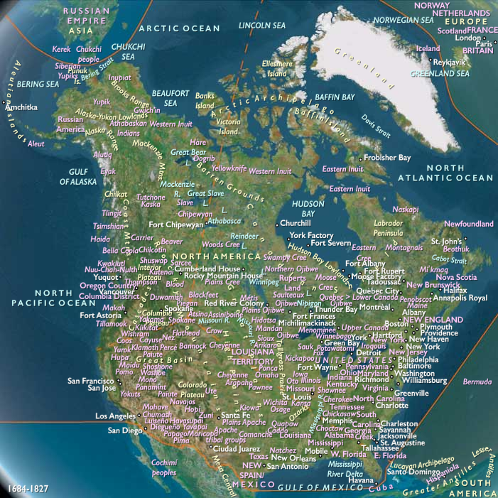
The boundaries of the newly declared Republic of West Florida include all territory south of parallel 31°N, east of the Mississippi River, and north of the waterway formed by the Iberville River, Amite River, Lake Maurepas, Pass Manchac, Lake Pontchartrain, and the Rigolets.
The Pearl River with its branch that flows into the Rigolets forms the eastern boundary of the republic.
On October 27, 1810, U.S. President James Madison had proclaimed that the United States should take possession of West Florida between the Mississippi and Perdido Rivers, based on a tenuous claim that it is part of the Louisiana Purchase.
The West Florida government opposes annexation, preferring to negotiate terms to join the Union.
Governor Fulwar Skipwith proclaims that he and his men will "surround the Flag-Staff and die in its defense."
William C. C. Claiborne is sent to take possession of the territory, entering the capital of St. Francisville with his forces on December 6, 1810.
Locations
People
Groups
- West Florida
- Mississippi, Territory of (U.S.A.)
- United States of America (US, USA) (Washington DC)
- Orleans, Territory of (U.S.A.)
- Louisiana, Territory of (U.S.A.)
- Spain, Bonapartist Kingdom of
- West Florida, Republic of
Topics
Subjects
Regions
Subregions
Years: 1810 - 1810
December
Locations
People
Groups
- West Florida
- Mississippi, Territory of (U.S.A.)
- United States of America (US, USA) (Washington DC)
- Orleans, Territory of (U.S.A.)
- Louisiana, Territory of (U.S.A.)
- Spain, Bonapartist Kingdom of
- West Florida, Republic of
Topics
Subjects
Regions
Subregions