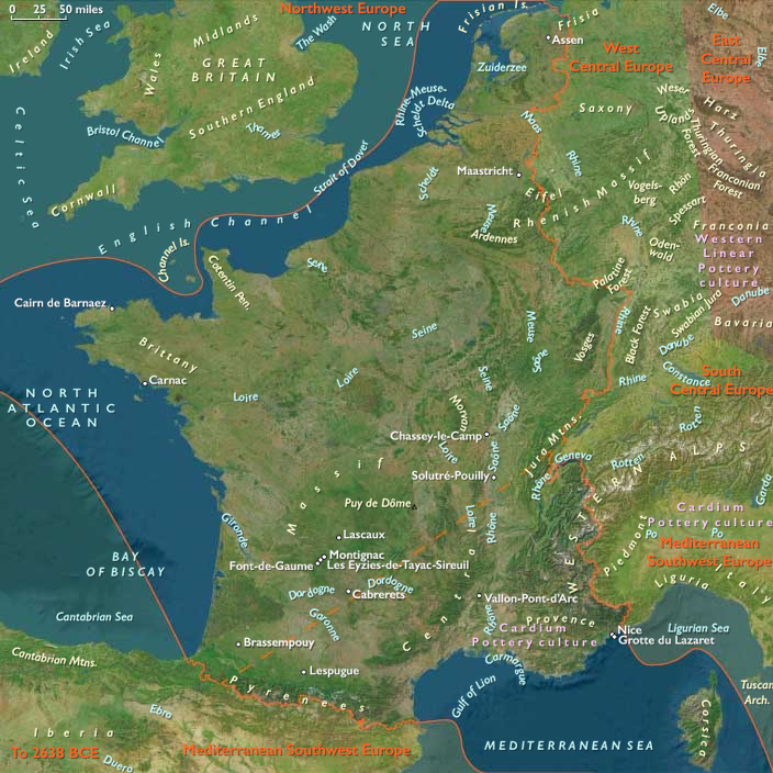
Artistic creativity flourishes beginning around 29,000–28,000 …
Years: 28557BCE - 7822BCE
Artistic creativity flourishes beginning around 29,000–28,000 BCE, as Early European Modern Humans produce their first small engravings, relief carvings, and animal sculptures. Over time, they create statuettes of ivory or stone, as well as occasional engravings of female figures on stone.
Many of the finest examples of prehistoric cave art, depicting animals in remarkable detail, have been preserved in French and Spanish caves, spanning a period of nearly 20,000 years.
Topics
- The Upper Paleolithic
- Last Glacial Maximum (LGM)
- Oldest Dryas
- Bølling Oscillation
- Older Dryas
- Allerød Oscillation
Commodoties
Subjects
Regions
Subregions
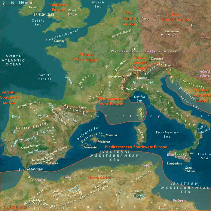
- Mediterranean West Europe
- Mediterranean Southwest Europe
- Atlantic Southwest Europe
- Atlantic West Europe
Related Events
Filter results
Showing 10 events out of 90 total
In recent times some of these bog bodies have emerged very well-preserved, providing valuable information about the religion and people who lived in Denmark during this period.
Some of the most well-preserved bog bodies from the Nordic Iron Age are the Tollund Man and the Grauballe Man.
This period is therefore referred to as the Roman Iron Age.
The Roman provinces, whose frontiers stop short of Denmark, nevertheless maintain trade routes and relations with Danish or proto-Danish peoples, as attested by finds of Roman coins.
The earliest known runic inscription dates back to about CE 200.
Southeast Europe (909 BCE – 819 CE): Iron Kingdoms, Roman Frontiers, and Byzantine Beginnings
Regional Overview
Between the Adriatic and the Black Sea, Southeast Europe stood for a millennium as the hinge between the Mediterranean world and the steppe.
Its twin landscapes—the eastern Danubian–Thracian plains and the western Adriatic–Illyrian mountains—produced parallel yet intertwined histories.
Both absorbed Hellenic colonization, entered the Roman orbit, and later weathered the migrations that forged medieval Europe.
The region’s story from the early Iron Age to late Antiquity is thus one of fusion and frontier, where Greek, Roman, Thracian, Illyrian, and Slavic worlds met and reshaped one another.
Geography and Environment
The region divides naturally:
-
Eastern Southeast Europe embraces the Lower Danube, Thracian plain, and Black Sea coast, enclosed by the Balkan and Carpathian arcs. Fertile lowlands sustained dense agrarian settlement, while the Danube served as both artery and barrier.
-
Western Southeast Europe rises into karstic uplands and Adriatic coasts, with sheltered island chains and mountain basins suited to mixed farming and seaborne trade.
Climatic variation—humid along the coasts, continental inland—produced complementary economies: grain, salt, and metals from the east; timber, livestock, and maritime goods from the west.
Seasonal river floods and Adriatic storms shaped transport calendars; alpine passes and sea lanes linked every valley to the wider Mediterranean.
Societies and Political Developments
Greek Colonies and Indigenous Kingdoms
From the 8th to 5th centuries BCE, Greek settlers established poleis along both coasts: Apollonia and Dyrrhachium on the Adriatic; Odessos, Mesambria, and Histria on the Black Sea.
Behind them, Illyrian, Thracian, and Geto-Dacian tribes forged early kingdoms—the Odrysian realm in Thrace, the Ardiaean and Dardanian dominions in the west.
These polities traded metals, grain, and slaves for imported wine, oil, and ceramics, mediating between the Mediterranean and the interior.
Rome and the Imperial Frontier
Between the 2nd century BCE and the 1st century CE, Rome absorbed the entire peninsula: Macedonia, Illyricum, Dalmatia, Moesia, Thrace, and briefly Dacia north of the Danube.
Roman roads—the Via Egnatia, Via Militaris, and Sava-Drava corridors—stitched the provinces together.
Urban centers such as Salona, Skupi, Nicomedia, and Serdica reflected Roman law and architecture, while legionary camps and bridgeheads (Apollodorus’ bridge at Drobeta) turned the Danube into the empire’s longest fortified line.
Mining in Dacia, shipyards on the Adriatic, and grain estates in Moesia underpinned prosperity until the 3rd-century crises.
Migrations and the Byzantine Transition
From the 3rd to 7th centuries CE, the frontier dissolved under waves of Goths, Huns, Avars, and Slavs.
Cities were sacked, repopulated, and repurposed as Byzantine forts.
The Eastern Roman Empire, centered on Constantinople, re-emerged as the stabilizing power, holding Thrace and the coastal Adriatic while fostering Christianization.
By the late 7th century, the First Bulgarian Empire rose in Moesia and Thrace; Croatian and Serbian principalities took form in the western mountains, bridging the late antique and medieval orders.
Economy and Exchange
Agriculture remained the foundation:
-
The Thracian plain and Wallachian lowlands exported grain and livestock along the Danube.
-
The Adriatic coasts specialized in wine, oil, salted fish, and amphora industries.
-
Mining of gold, silver, and iron in Dacia and the western ranges enriched both local chieftains and Roman prefects.
Trade routes—riverine, overland, and maritime—made the region a corridor between the Aegean, the Pannonian plain, and the steppe.
After Rome’s decline, Byzantine and Bulgar administrations preserved key arteries, ensuring continuity of commerce despite political fragmentation.
Technology and Material Culture
Iron metallurgy and Roman engineering reshaped daily life.
Stone bridges, aqueducts, and bath complexes signaled urban sophistication; rural estates used the iron plow to expand cultivation.
Local craftsmanship persisted: Thracian and Illyrian metalwork, Dacian goldsmithing, and later Slavic wood and textile arts.
Christian churches and monasteries, often rising atop pagan sanctuaries, announced new spiritual geographies while reusing classical masonry.
Belief and Symbolism
Religious life reflected the region’s pluralism:
-
Indigenous cults—Zalmoxis, the Thracian Horseman—coexisted with Greek polytheism and Roman state worship.
-
Christianity spread from urban bishoprics by the 4th century CE, producing early saints and councils.
-
Slavic and Bulgar paganisms, with sky- and ancestor-deities, persisted until conversion in the 8th–9th centuries.
Thus the region became a spiritual palimpsest, each new faith overlaying rather than erasing the old.
Adaptation and Resilience
Southeast Europe’s resilience lay in its geographical layering: river corridors, mountain refuges, and island coasts offered fallback zones in war or climate stress.
Agro-pastoral economies allowed mobility; fortified towns and hillforts provided refuge during invasions.
Byzantine fiscal systems and Bulgar tribute networks recycled Roman infrastructures, ensuring survival of settlement and trade patterns despite continual upheaval.
Regional Synthesis and Long-Term Significance
By 819 CE, Southeast Europe had completed its ancient cycle.
In the east, Byzantine Thrace and the Bulgar kingdom defined a Christian–steppe frontier along the Danube.
In the west, Slavic kingdoms grew amid the ruins of Roman Dalmatia, while the Adriatic cities preserved classical urbanism under imperial and papal influence.
Greek colonies, Roman provinces, and barbarian migrations had fused into a single cultural continuum—one that naturally divides into eastern (Danubian–Thracian) and western (Adriatic–Illyrian) spheres yet remains bound by geography, trade, and faith.
This equilibrium of coast and hinterland, empire and tribe, set the pattern for the medieval Balkans: a region perpetually contested but never peripheral, mediating between the Mediterranean world and the steppes beyond.
Eastern Southeast Europe (909 BCE – 819 CE) Early Iron & Antiquity — Greek Poleis, Thracians & Dacians, Rome & Byzantium, Migrations and Bulgars
Geographic and Environmental Context
Eastern Southeast Europe includes Turkey-in-Europe (Thrace); Greece’s Thrace; Bulgaria (except its southwest); Romania & Moldova; northeastern Serbia; northeastern Croatia; extreme northeastern Bosnia & Herzegovina.
-
Anchors: Greek Black Sea poleis (Histria, Tomis/Constanța, Callatis/Mangalia, Odessos/Varna, Mesambria/Nessebar, Apollonia/Sozopol), Thrace (Odrysian kingdom), Moesia (Danube limes), Dacia(Transylvania & Wallachia), Lower Danube legionary line, Carpathian–Balkan passes.
Climate & Environmental Shifts
-
First-millennium variability; fertile Thracian and Wallachian plains supported dense settlement; Danube avulsions required continual river management.
Societies & Political Developments
-
Greek colonies flourished (7th–5th c. BCE) along the western Black Sea.
-
Thracian Odrysian kingdom (5th–4th c. BCE) and Geto-Dacians north of the Danube rose to prominence.
-
Rome annexed Moesia and Thrace; Dacia (106–271 CE) north of the Danube briefly Romanized with cities, mines, roads; Danube limes fortified.
-
Migrations: Goths (3rd–4th c.), Huns (5th c.), Avars and Slavs (6th–7th c.) reconfigured the region;
-
First Bulgarian Empire (from 681 CE) entrenched in Moesia/Thrace; Byzantium held Thrace and coastal cities.
Economy & Trade
-
Grain, wine, salt, and livestock moved along the Danube; Black Sea ports exported to the Aegean–Mediterranean; mining (gold/silver in Dacia, iron in Thrace).
-
Roman urbanism (roads, bridges e.g., Apollodorus’ bridge near Drobeta) integrated the frontier.
Technology & Material Culture
-
Iron plowshares; Roman engineering; Thracian/Dacian metalwork; Byzantine fortifications.
-
Urban mosaics, inscriptions, temples; later churches and monasteries.
Belief & Symbolism
-
Thracian and Dacian cults (horseman, Zalmoxis); Greek polytheism; Roman state cults → Christianity (by late Roman/Byzantine era).
-
Early Slavic and Bulgar paganisms persisted into 8th–9th c., gradually Christianizing.
Environmental Adaptation & Resilience
-
Riverine transport and oasis agriculture stabilized supply; fortified towns and hillforts provided refuge; steppe pastoralism remained flexible under aridity pulses.
Legacy & Transition
By 819 CE, Eastern Southeast Europe was a braided frontier of Byzantine Thrace, Bulgar power, Slavic communities, and legacy Roman–Greek Black Sea cities. The Lower Danube’s fortified line, Thracian plain granaries, and coastal emporia formed the scaffolding for the medieval dynamics to come.
Near East (909 BCE – 819 CE) Early Iron and Antiquity — Greeks of Ionia, Levantine Tyre, Roman–Byzantine Egypt, Arabia’s Caravans
Geographic and Environmental Context
The Near East includes Egypt, Sudan, Israel, most of Jordan, western Saudi Arabia, western Yemen, southwestern Cyprus, and western Turkey (Aeolis, Ionia, Doris, Lydia, Caria, Lycia, Troas) plus Tyre (extreme SW Lebanon).-
Anchors: the Nile Valley and Delta; Sinai–Negev–Arabah; the southern Levant (with Tyre as the sole Levantine node in this subregion); Hejaz–Asir–Tihāma on the Red Sea; Yemen’s western uplands/coast; southwestern Cyprus; western Anatolian littoral (Smyrna–Ephesus–Miletus–Halicarnassus–Xanthos; Troad).
Climate & Environment
-
Nile’s late antique variability; Aegean storms seasonal; Arabian aridity persistent but terraces/cisterns mitigated.
Societies & Political Developments
-
Western Anatolia Greek city-states (Ionia–Aeolia–Doria, with Troad): Miletus, Ephesus, Smyrna, etc.
-
Tyre (sole Near-Eastern Levantine node here) dominated Phoenician seafaring.
-
Egypt (Ptolemaic → Roman → Byzantine): Nile granary and Christianizing hub.
-
Arabian west: caravan kingdoms and Hejaz–Asir oases; western Yemen incense terraces and caravan polities.
-
Southwestern Cyprus embedded in Hellenistic–Roman maritime circuits.
Economy & Trade
-
Grain–papyrus–linen from the Nile; olive–wine Aegean; incense–myrrh from Yemen; Red Sea lanes linked to Aden–Berenike nodes (outside core but connected).
-
Tyre exported craft goods and purple dye.
Technology & Material Culture
-
Iron agriculture and tools; triremes and merchant galleys; advanced terracing, cisterns; lighthouse/harbor works.
Belief & Symbolism
-
Egyptian polytheism → Christianity (Alexandria); Greek civic cults; Tyrian traditions; Arabian deities; monasticism along Nile/Desert.
Adaptation & Resilience
-
Canal maintenance buffered Nile shocks; terraces/cisterns stabilized Arabian farming; Aegean coastal redundancy protected shipping routes.
Transition
By 819 CE, the Near East was a multi-corridor world of Nile granaries, Ionia’s city-coasts, Tyre’s Phoenician legacy, and Arabian incense roads — a foundation for the medieval dynamics ahead (Ayyubids in Syria/Egypt next door, Abbasids beyond, and the Ionian–Anatolian littoral under Byzantine/Nicaean arcs).
Middle East (909 BCE – 819 CE) Early Iron and Antiquity — Urartu, Achaemenids, Parthians, Sasanian Frontiers
Geographic and Environmental Context
The Middle East includes Iraq, Iran, Syria, Armenia, Georgia, Azerbaijan, eastern Jordan, most of Turkey’s central/eastern uplands (including Cilicia), eastern Saudi Arabia, northern Oman, Qatar, Bahrain, the UAE, northeastern Cyprus, and all but the southernmost Lebanon.-
Anchors: the Tigris–Euphrates alluvium and marshes; the Zagros (Luristan, Fars), Alborz, Caucasus (Armenia–Georgia–Azerbaijan); northern Syrian plains and Cilicia; Khuzestan and Fars lowlands; the Arabian/Persian Gulf littoral (al-Ahsa–Qatar–Bahrain–UAE–northern Oman); northeastern Cyprus and the Lebanon coastal elbow (north).
Climate & Environment
-
Continental variability; oases survived by canal upkeep; Gulf fisheries stable; Caucasus snows fed headwaters.
Societies & Political Developments
-
Urartu (9th–6th c. BCE) fortified Armenian highlands;
-
Achaemenid Persia (6th–4th c. BCE) organized satrapies across Iran, Armenia, Syria uplands, Cilicia; Royal Road linked Susa–Sardis through our zone.
-
Hellenistic Seleucids, then Parthians (3rd c. BCE–3rd c. CE) and Sasanians (3rd–7th c. CE) ruled Iran–Mesopotamia; oases prospered under qanat/karez and canal regimes.
-
Transcaucasus (Armenia, Iberia/Georgia, Albania/Azerbaijan) oscillated between Iranian and Roman/Byzantine influence; northeastern Cyprus joined Hellenistic–Roman networks.
-
Arabian Gulf littoral hosted pearling/fishing and entrepôts (al-Ahsa–Qatif–Bahrain).
Economy & Trade
-
Irrigated cereals, dates, cotton, wine; transhumant pastoralism; Gulf pearls and dates.
-
Long-haul Silk Road and Royal Road flows; qanat irrigation expanded in Iran.
Technology & Material Culture
-
Iron plowshares, tools, and weapons; fortifications; qanat engineering; road stations (caravanserais earlier variants).
-
Arts: Urartian bronzes; Achaemenid stonework; Sasanian silver; Armenian and Georgian ecclesiastical arts (late).
Belief & Symbolism
-
Zoroastrianism, Armenian/Georgian Christianity, local cults; Jewish and early Christian communities in oases/ports; syncretism in frontier cities.
Adaptation & Resilience
-
Canal/qanat redundancy, pasture–oasis integration, distributed entrepôts (northeastern Cyprus, Gulf) hedged war and drought.
Transition
By 819 CE, the Middle East was a layered highland–oasis–Gulf system under Sasanian–Byzantine frontiers giving way to Islamic polities.
Depletion of cultivated land in the last century BCE seems to have contributed to increasing migrations in northern Europe and increasing conflict between Teutonic tribes and Roman settlements in Gaul.
Roman artifacts are especially common in finds from the first century.
It seems clear that some part of the Danish warrior aristocracy served in the Roman army.
Western Southeast Europe (909 BCE – 819 CE) Early Iron & Antiquity — Greek Colonies, Illyrian Kingdoms, Rome, and Migrations
Geographic and Environmental Context
Western Southeast Europe includes Greece (outside Thrace), Albania, Montenegro, North Macedonia, Kosovo, most of Bosnia, southwestern Serbia, most of Croatia, and Slovenia.-
Anchors: Epidamnos/Dyrrhachium (Durrës), Apollonia (Albania), Issa (Vis), Pharos (Hvar), Narona (Neretva), Salona (Split), Scodra (Shkodër) and Skodra Lake, Skupi (Skopje), Siscia (Sisak), Aquileia approaches in the northwest.
Climate & Environmental Shifts
-
Generally temperate; agricultural basins productive; Adriatic storms structured sailing seasons.
Societies & Political Developments
-
Greek colonies (6th–4th c. BCE) dotted the Adriatic; Illyrian tribes formed kingdoms (e.g., Ardiaei).
-
Rome subdued Illyria (3rd–2nd c. BCE); established Dalmatia, Pannonia, Macedonia provinces; roads (Via Egnatia west end) and cities (Salona, Scodra, Narona).
-
Late Antiquity: Goths, Huns, Avars, and Slavs crossed; Slavic settlement (6th–7th c.) reshaped the interior; Byzantium held coastal nodes; early Croatian and Serbian polities emerged in the 7th–9th c.; Avar Khaganate waned.
Economy & Trade
-
Coastal wine–oil–fish-sauce industries (amphorae); inland grain and livestock; timber and salt.
-
Adriatic coasting linked Italy–Balkans; Sava–Drava and Vardar–Morava carried inland traffic.
Technology & Material Culture
-
Iron tools/weapons; Roman masonry, baths, amphitheaters; hillforts continued in uplands; early medieval timber churches and forts appeared.
Belief & Symbolism
-
Greek and Roman cults; Thracian/Illyrian deities; Christianity spread by late Roman era; Slavic paganism persisted into 8th–9th c.
Environmental Adaptation & Resilience
-
Agro-pastoral + maritime economies hedged risk; fortified coastal towns and hillforts provided continuity through migrations.
Legacy & Transition
By 819 CE, Western Southeast Europe was a layered frontier: Byzantine–Roman urbanism along the Adriatic, Slavic interior communities, and early Croatian/Serbian formations — a base for the medieval developments to come.
Southwest Europe (909 BCE – 819 CE): From Roman Seas to Mountain Kingdoms
Regional Overview
Between the wine-dark coasts of the western Mediterranean and the storm-swept bays of the Atlantic, Southwest Europe bridged the worlds of classical empire and early medieval kingdom.
From the Po Valley and Sicilian ports to the Cantabrian uplands and Galician headlands, it was a region of deep historical layering — Roman legacies enduring beneath Lombard strongholds, Visigothic courts, and the early Christian monarchies of Iberia.
By the early ninth century CE, the Mediterranean and Atlantic spheres were diverging yet intertwined: one turning toward the Byzantine–Islamic maritime system, the other toward Carolingian and Asturian frontiers that would shape Europe’s western destiny.
Geography and Environment
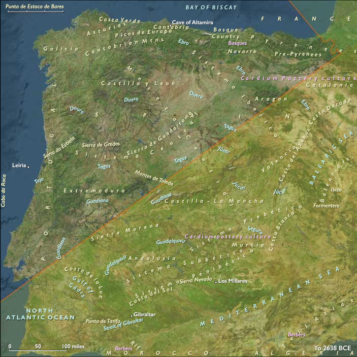
Southwest Europe is defined by its dual maritime faces — the Mediterranean littoral of Italy, Sicily, Sardinia, and southeastern Iberia, and the Atlantic–Cantabrian rim of northern Spain and Portugal.
Volcanic uplands, mountain arcs (the Apennines and Cantabrians), and fertile basins like the Po Valley and Douro formed alternating belts of abundance and refuge.
A Mediterranean climate dominated the south and east: wet winters, hot summers, and dependable harvests of grain, vines, and olives.
Along the Atlantic, milder and wetter conditions favored forests, pastures, and fisheries.
Rivers — Po, Tiber, Douro, Tagus, and Ebro — were arteries of settlement and trade, linking inland towns to their maritime outlets.
Societies and Political Developments
Mediterranean Core: From Empire to Maritime Republics
In Italy and the central Mediterranean, the dissolution of Roman order yielded a mosaic of powers.
Byzantine administrators retained control over southern Italy, Sicily, and Malta, while Lombard duchies dominated the interior.
Ports such as Naples, Venice, and Palermo emerged as autonomous or semi-autonomous nodes in the seaborne networks that connected Europe to the Byzantine and Islamic worlds.
Further west, Visigothic Hispania maintained tenuous unity until the early eighth century, when the Umayyad conquest (711 CE) reshaped Iberia’s Mediterranean coast.
Atlantic Uplands: Christian Refuge and Frontier Consolidation
North of the Ebro, the Kingdom of Asturias consolidated resistance in the mountain bastions of Galicia and León.
Its rugged geography favored small, defensible communities and itinerant courts rather than expansive bureaucracy.
Along the Galician and Portuguese coasts, fishing villages and riverine settlements survived upheaval by turning outward — trading timber, salt, and grain northward to Brittany and the Channel.
These Atlantic zones preserved older Roman and Celtic traditions while integrating Christian monasticism and the emerging pilgrimage cult of St. James, whose shrine at Compostela would later knit western Christendom together.
Economy and Trade
The region’s economy remained diverse and regionally specialized.
-
Mediterranean Southwest Europe continued the Roman pattern of intensive agriculture: grain, vines, olives, and citrus along irrigated lowlands, complemented by pottery, glassware, textiles, and metalwork in coastal workshops.
-
Maritime commerce bound the Tyrrhenian and Adriatic cities to North Africa, the Levant, and Byzantine Greece, exchanging oil, wine, salt, and spices.
-
In Atlantic Southwest Europe, mixed farming and transhumant pastoralism supported highland communities, while fisheries, salt pans, and shipyards sustained coastal trade.
The Rhone and Po valleys served as inland corridors to Central Europe, while the Douro and Tagus linked Iberia’s uplands to the Atlantic.
Technology and Material Culture
Roman engineering remained the skeleton of the landscape: aqueducts, roads, and terraced farms continued in use long after imperial authority waned.
In the Lombard and Byzantine zones, stone fortifications and church complexes dominated townscapes.
Shipbuilding flourished: Mediterranean galleys with lateen sails and Atlantic cogs adapted to rougher seas both expanded in sophistication.
Water mills powered flour production in Alpine and Galician valleys, while terraced vineyards and olive groves reclaimed slopes once abandoned during late antiquity.
Belief and Symbolism
Christianity unified this fragmented world while expressing regional diversity.
The Papacy in Rome and the monasteries of Monte Cassino and Cluny (just beyond this region’s northern edge) revitalized learning and administration.
In Iberia, Christian identity crystallized through resistance to Islamic rule; monasteries in Asturias and Galicia became bastions of literacy and art.
Across the Mediterranean coasts, Byzantine mosaics and basilicas echoed Rome’s sacred heritage, while Sicilian and Sardinian churches absorbed eastern iconography.
In all lands, sacred geography — from the pilgrim roads of Compostela to the tombs of saints and martyrs — replaced imperial capitals as centers of meaning.
Adaptation and Resilience
The fusion of agricultural stability, maritime trade, and religious cohesion gave Southwest Europe remarkable resilience.
The Mediterranean cities adapted through commerce and diplomacy, sustaining continuity amid invasion; the Atlantic uplands relied on self-sufficiency, kinship, and geography to survive as Christian enclaves.
Environmental flexibility — terrace farming, irrigation, diversified herding — ensured survival through droughts and political shocks alike.
Regional Synthesis and Long-Term Significance
By 819 CE, Southwest Europe embodied the meeting of three worlds:
-
The Byzantine–Mediterranean East, linked through Italian ports and island fortresses;
-
The Islamic South, newly established in Iberia and Sicily;
-
The Frankish and Christian North, consolidating in the Pyrenees and the Loire.
This region’s mountain refuges, fortified coasts, and enduring cities preserved Roman infrastructures while incubating new cultural forms — Christian monastic learning, Lombard law, and seafaring enterprise.
It was here, along these seas and uplands, that Europe’s western Mediterranean civilization survived the disintegration of empire and prepared for the revival of the medieval Mediterranean world that would follow.
Mediterranean Southwest Europe (909 BCE – CE 819): Maritime Cities, Mountain Frontiers, and Cultural Crossroads
Geographic and Environmental Context
Mediterranean Southwest Europe includes Italy (together with Sardinia and Sicily), Malta, Southeastern Spain, and the Balearic Islands.
-
The subregion features the Italian Peninsula, volcanic uplands such as Mount Etna and Vesuvius, the Apennines, fertile river plains like the Po Valley, and extensive Mediterranean coastlines.
-
Its strategic islands and ports made it a focal point for maritime trade and naval power in the central and western Mediterranean.
Climate and Environmental Shifts
-
A Mediterranean climate with wet winters and dry summers favored vineyards, olive groves, and grain cultivation.
-
Seasonal rainfall variability could impact agricultural yields, prompting the use of irrigation in some areas.
-
Volcanic activity occasionally disrupted local economies but also enriched soils.
Societies and Political Developments
-
The early medieval centuries saw the transition from Late Roman provincial governance to the Byzantine administration in parts of southern Italy and the islands, and the rise of Lombard rule in much of the peninsula.
-
Coastal Spain experienced both Visigothic and, after 711 CE, Umayyad control.
-
Maritime cities such as Naples, Venice, and Palermo became vital trade hubs, with varying degrees of autonomy under larger political powers.
-
Malta and the Balearics were contested by Byzantine, North African, and Iberian interests.
Economy and Trade
-
Agriculture produced grain, wine, olive oil, fruits, and vegetables for local use and export.
-
Craft industries produced pottery, glassware, and metalwork.
-
Maritime trade linked the subregion to North Africa, the Levant, and Atlantic Europe, carrying goods such as spices, textiles, and precious metals.
-
The Po Valley and other fertile plains supplied surplus grain to urban markets.
Subsistence and Technology
-
Terrace farming on steep slopes maximized cultivation of vines and olives.
-
Roman-era aqueducts and irrigation systems remained in use in many areas.
-
Shipbuilding flourished in coastal cities, with vessels adapted for both trade and warfare.
Movement and Interaction Corridors
-
The Mediterranean Sea served as the principal conduit for commerce and cultural exchange.
-
Alpine passes connected northern Italy to transalpine trade routes into West Central Europe.
-
Coastal shipping routes linked Italian and Spanish ports to island markets and North African harbors.
Belief and Symbolism
-
Christianity was the dominant faith, with the Papacy in Rome exerting significant spiritual and political influence.
-
Monasteries, cathedrals, and churches served as cultural centers, preserving classical learning and fostering the arts.
-
Religious architecture and mosaics reflected a blend of Roman, Byzantine, and local traditions.
Adaptation and Resilience
-
Economic diversity across agriculture, trade, and crafts provided resilience against localized crises.
-
Coastal defenses and fortified hill towns protected against raids, especially from seaborne attackers.
-
Control of strategic straits and ports ensured influence over maritime traffic.
Long-Term Significance
By CE 819, Mediterranean Southwest Europe was a maritime and cultural hub bridging western Europe, the Byzantine world, and North Africa, maintaining continuity with its Roman past while adapting to shifting political realities.
Years: 28557BCE - 7822BCE
Topics
- The Upper Paleolithic
- Last Glacial Maximum (LGM)
- Oldest Dryas
- Bølling Oscillation
- Older Dryas
- Allerød Oscillation
Commodoties
Subjects
Regions
Subregions
- Mediterranean West Europe
- Mediterranean Southwest Europe
- Atlantic Southwest Europe
- Atlantic West Europe